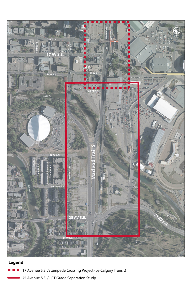
25 Avenue S.E. LRT Grade Separation Study
Project update
The final short- and long-term recommendations were presented to Council for approval on May 28, 2018. Council approved the implementation of the short-term recommendations as funding comes available. They directed Administration to re-evaluate the Transit Oriented Development potential for all the long-term concepts once:
- Flood mitigation measures are in place and a new floodway zone has been identified; and/or
- New land use and development information is available for the Erlton Station area.
A final long-term design will be selected once we have the additional information referenced above.
Project overview
The City of Calgary conducted a functional planning study to grade separate 25 Avenue S.E. and the Red Line LRT tracks. The technical report identifies short-term and long-term improvements in the study area. The objective of the study is to improve travel through this area for people driving, walking, cycling and taking transit.
The Red Line LRT tracks cross over 25 Avenue S.E. at-grade (street level) east of Macleod Trail. As a result, the traffic signals at this intersection are often interrupted by trains travelling to and from the Erlton LRT station. Grade separation of the LRT tracks will eliminate delays to the traffic signals due to the LRT.
(Click for larger image)
Final recommendations
Short-term improvements
The final plan is a long-term plan that is not anticipated to be implemented for more than 20 years. Due to the long-term nature of the final plan, short-term solutions to some of the identified issues were explored. In the short-term we could make the following improvements:
- Install traffic signals with newer technology at Macleod Trail and 25 Avenue S.
- Construct a pathway along the east side of Macleod Trail to improve connectivity between the Elbow River Pathway and Reader Rock Garden.
- Re-grade the pathway between Macleod Trail and the LRT tracks to improve floodwater conveyance in the area.
- Improve eastbound traffic flow on 25 Avenue S. by re-assigning one traffic lane from a shared through/right to a dedicated right-turn lane (eastbound to southbound).
- Reduce the speed limit on Macleod Trail to 50 km/hr in the study area, to improve the pedestrian environment.
Long-term plan
An evaluation of the concepts has shown that all concepts will improve the intersection, but we require additional information that is not currently available to select a final design. To select a final design, additional information regarding the floodway along the Elbow River and plans for the future development of lands within the study area is required.
The current Land Use Bylaw prohibits building development within the floodway. A large portion of area considered for development within the study area is currently within the floodway. The Province is updating flood inundation and hazard mapping for Calgary as part of their Flood Hazard Identification Project. Once this information is available it will help us determine the impact of future floods on each concept and future developments within the study area.
Stakeholders have told us that revitalization of the community is important. A final design that supports future development of lands within the study area will help revitalize the community. Understanding the development plans for privately owned lands within the study area will help us determine what impacts the concepts will have on future developments. Currently, not all landowners within the study area have developed plans for their lands.
Currently there is no funding available for construction of a final design.
Concept evaluation
Over the summer and fall of 2017 a technical review of the three concepts presented to the public took place, it included public feedback. The concepts were also refined to make additional improvements for people walking, cycling, driving and taking transit.
- 25 Ave SE LRT Grade Separation Study - Concept A - Elevated LRT Station
- 25 Ave SE LRT Grade Separation Study - Concept B - Bi-Directional Median Flyover
- 25 Ave SE LRT Grade Separation Study - Concept B2 - Single Lane Median Flyover
- 25 Ave SE LRT Grade Separation Study - Concept C - Relocated At-Grade LRT Station
Refining the concepts included the creation of Concept B2, a revised version of Concept B. The differences in the concepts can be seen by viewing the individual concept drawings above.
A summary of the technical review can be found within the technical report.
History of the Study Area
In 2009, the 25 Avenue S.E. Connector project developed a Recommended Plan for 25 Avenue S.E. from Macleod Trail to Blackfoot Trail. The recommended plan determined future upgrades to the area, including a full interchange at 25 Avenue S.E. and Macleod Trail. It also determined the lands that would be required for the future upgrades.
In 2015, Council directed Administration to look at alternatives to an interchange at this location. The recommended interchange design did not align with the roles of the transportation facilities in the area as identified in the Calgary Transportation Plan. The 25 Avenue S.E. LRT Grade Separation Feasibility Study was undertaken in 2016. It determined that it is possible to grade separate the Red Line LRT tracks and 25 Avenue S.E. without construction of a full interchange.
Engagement process
Information about the engagement process can be found on the project's engagement page.
Study feedback
If you have questions or would like more information about the study please contact 311.