The City of Calgary Land Use Bylaw 1P2007
Top of page

PART 1: INTERPRETATION OF THIS BYLAW
Division 2: Definitions and Methods
General Definitions
3
"actual front setback area" means the area of a parcel defined by the front property line, the side property lines that intersect with the front property line, and a line parallel to the front property line measured at the farthest building setback from the front property line.
4
"actual side setback area" means the area of a parcel defined by a side property line and a line parallel to that side property line measured at the farthest building setback from the side property line and terminating where that area meets the actual front setback area, the rear setback area or another actual side setback area.
7
"ancillary structure" means, with reference to building height, an essential component, other than a sign or flag pole, that protrudes above the roof of a building and which is necessary for the functioning of a building including, but not limited to:
7.1
"Appeal Body" means the board hearing a subdivision or development permit appeal in accordance with the Municipal Government Act.
8
"assembly area" means an area within a building where people assemble for ceremonies, religious services, educational, recreation, social or sporting events.
a
where there are at least two other buildings on the same block face, the average of the greatest geodetic elevation of the contextual adjacent buildings, excluding ancillary structures;
b
where there is only one other building on the same block face, the greatest geodetic elevation of such building, excluding ancillary structures; and
c
where there is no other building on the same block face, a point 8.6 metres above the greatest geodetic elevation at grade on the subject parcel.
13
"balcony" means a horizontal platform that is attached to a building above the first storey floor level and is intended for use as an outdoor amenity space.
17
"bicycle parking stall" means an area approved as bicycle parking stall — class 1 or bicycle parking stall — class 2 that is equipped to store a bicycle and must include a device:
19
"bicycle parking stall — class 2" means a bicycle parking stall in an unsecured or uncontrolled area.
b
portions of the building greater than 2.4 metres above grade and with a depth less than 1.0 metres, measured from the wall directly below;
c
portions of eaves, roofs, pergolas and other similar elements with a depth less than 1.0 metres, measured from the wall directly below;
23
"building depth" means the distance from the front property line to the farthest portion of a main residential building excluding decks, eaves, landings and patios, determined by:
a
establishing a line connecting the midpoint of the front property line and the midpoint of the rear property line; then
b
extending a line from the portion of the main residential building farthest from the front property line to a point where it intersects the line connecting the midpoint of the front property line and the midpoint of the rear property line at a right angle; and
c
measuring the distance from the point where the two lines intersect to the midpoint of the front property line.
24
"building height" means the height of a building, excluding ancillary structures, determined by measuring from grade, except where otherwise referenced in a land use district or general rules applicable to a land use district.
27
"building setback" means the distance from a property line to the point on a parcel where a building is located measured at a right angle from the property line to which it relates.
28.1
"carriage house lot" means a small parcel containing one Dwelling Unit in a Single Detached Dwelling or Semi-detached Dwelling where the parcel:
b
is connected to a public street using a panhandle with a front property line that is between 3.0 metres and 1.5 metres in length.
28.2
"Central Business District Improvement Fund" means a civic fund into which financial contributions made towards additional floor area ratio in accordance with the incentive provisions in Part 13, Division 3 are collected.
32
"commercial multi-residential uses" means any one or more of the following uses, when referenced in a multi-residential district:
33
"common amenity space" means a space designed for active or passive recreational use that is provided for the use of all of the occupants of a development.
b
in the case of low density residential district where the building is on a parcel designated as a residential district; and
a
where there are at least two other buildings on the same block face, the average building depth of the contextual adjacent buildings plus 4.6 metres;
b
where there is only one other building on the same block face, the building depth of such building plus 4.6 metres; and
a
where there are at least two other buildings on the same block face, the average building setback from the front property line of the contextual adjacent buildings;
b
where there is only one other building on the same block face, the building setback from the front property line of the contextual adjacent building; and
c
where there is no other building on the same block face, 3.0 metres measured from the front property line.
40
"contextual height" means the average contextual high point, less the greatest building reference point.
a
where there are at least two other buildings on the same block face, the average building setback from the property line shared with a street of the contextual adjacent buildings;
b
where there is only one other building on the same block face, the building setback of such building from a property line shared with a street; and
c
where there is no other building on the same block face, zero metres from a property line shared with a street.
41.1
"copy" means any image, written material, structure, graphics, pictures, logo, symbol or letters placed on a sign.
Sign Illustration 1:
44
"corner visibility triangle" means a triangular area formed on a corner parcel by the two curb lines and a straight line which intersects them 7.5 metres from the corner where they meet.
45
"cottage building" means a residential building located within a Cottage Housing Cluster that is restricted in size and contains one, two or three Dwelling Units.
47
"deck" means an uncovered horizontal structure with a surface height greater than 0.6 metres above grade at any point that is intended for use as an outdoor amenity space but does not include a balcony.
48
"density" means the number of Dwelling Units and Live Work Units on a parcel, expressed in units per hectare or in units per parcel, but does not include Secondary Suites or Backyard Suites.
50
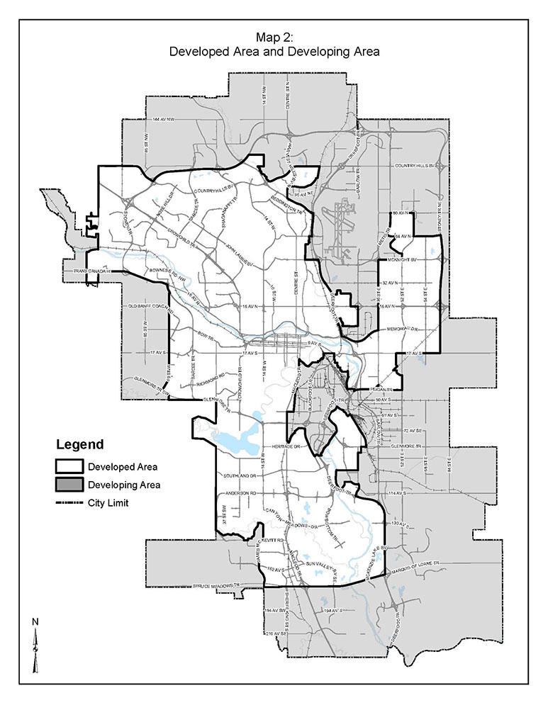
"Developed Area" means the area identified as the Developed Area on the Developed Area and Developing Area Map and illustrated on Map 2.
51
"Developing Area" means the area identified as the Developing Area on the Developed Area and Developing Area Map and illustrated on Map 2.
53
"Development Authority" means a person or body appointed as a Development Authority as contemplated by and in accordance with the Municipal Government Act.
54
"development completion permit" means a permit issued by a Development Authority confirming that the requirements of a development permit have been satisfactorily completed.
55
"development permit" means a document authorizing a development, issued by a Development Authority pursuant to this Bylaw or any previous Bylaw governing land use within the City, and includes the plans and conditions of approval.
55.1
"digital display" means a device intended to display copy using electronic screens, projection, television, computer video monitors, liquid crystal displays (LCD), light emitting diode (LED) displays, or any other similar electronic, computer generated or digital technology.
57.1
"district energy" means infrastructure consisting of insulated pipes, pumps, metering systems and thermal production facilities capable of transferring heat energy through a controlled conductive medium carried between multiple sites for uses including, but not limited to, space heating, chilled water, domestic hot water heating and industrial processes, A district energy system may be designed to serve any group of buildings by means of one or a combination of thermal or energy heat plants and pipe systems.
60
"fence" means a structure which may be used to prevent or restrict passage, to provide visual screening, sound attenuation, yard décor, protection from dust or the elements, or to mark a boundary.
61
"flood fringe" means those lands abutting the floodway, the boundaries of which are indicated on the Floodway/Flood Fringe Maps that would be inundated by floodwaters of a magnitude likely to occur once in one hundred years.
63
"floor area ratio" means the quotient of the total gross floor area of all buildings on a parcel divided by the area of the parcel.
63.1
"floor plate area" means the horizontal cross-section of a floor, between the floor and the next floor above, measured to the glass line, or where there is no glass line, to the outside surface of the exterior walls and includes all mechanical equipment areas and all open areas inside a building that do not contain a floor, including atriums, elevator shafts, stairwells and similar areas.
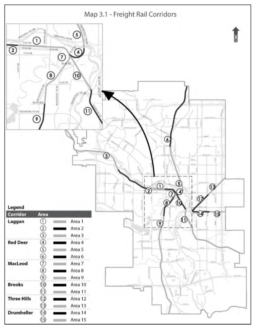
Map 3.1 - Freight Rail Corridors
b
in the case of a parcel that adjoins more than one street, the shortest property line that is parallel to the direction of travel on the street; and
c
in the case of a parcel that adjoins more than one street and where the property lines adjoining streets are of equal length, the property line adjoining the street to which the parcel has been municipally addressed.
67
"front setback area" means an area of a parcel defined by the front property line, the side property lines that intersect with the front property line, and a line parallel to the front property line measured at the minimum depth of the setback area required by the District.
70
"gross floor area" means the sum of the areas of all above grade floors of a building measured to the glassline, or where there is no glassline, to the outside surface of the exterior walls, or where buildings are separated by firewalls, to the centre line of the common firewalls, and includes all mechanical equipment areas and all open areas inside a building that do not contain a floor including atriums, elevator shafts, stairwells and similar areas.
71
"gross usable floor area" means, for the purpose of calculating motor vehicle parking stalls, bicycle parking stalls and loading stalls, the total horizontal area of every enclosed floor and mezzanine used exclusively by a single use area in a building, and is measured from the exterior face of the exterior wall and the centreline of an interior partition wall that separates at least two uses, but does not include:
74.1
"irregular parcel" means a parcel that is inconsistent in shape with other parcels in the neighbourhood, where the property line opposite to and farthest from the front property line:
75.1
"laboratory" means a facility where scientific research, experiments and measurement are performed for the purposes of providing information or as part of research and development.
77
"landscaped area" means that portion of a parcel that is required to be a hard surfaced landscaped area or soft surfaced landscaped area.
a
with a gross vehicle weight stated by the manufacturer, vehicle signage, or vehicle registration, to be in excess of 4536 kilograms;
84
"low density residential district" means any one or more of the land use districts described in Part 5.
89
"main residential building" means a building containing one or more Dwelling Units but does not include a Backyard Suite.
93
"mounting height" means the vertical distance between the lowest part of the light fixture and the grade directly below the light fixture.
b
that on the date the land use bylaw becomes effective does not, or in the case of a building under construction will not, comply with the land use bylaw.
97
"open balcony" means a balcony that is unenclosed on three sides, other than by a railing, balustrade or privacy wall.
98
"overland flow area" means those lands abutting the floodway or the flood fringe, the boundaries of which are indicated on the Floodway/Flood Fringe Maps that would be inundated by shallow overland floodwater in the event of a flood of a magnitude likely to occur once in one hundred years.
100
"parcel coverage" means the cumulative building coverage of all buildings on a parcel excluding, Accessory Residential Buildings which in aggregate are less than 10.0 square metres.
101
"parcel depth" means the length of a line joining the mid-points of the front property line and the rear property line.
102
"parcel width" means the distance between the side property lines of a parcel measured at a right angle to the mid-point of the shortest side property line.
102.1
"parking area — short stay" means an area designed for the parking of motor vehicles within a building where:
b
there is convenient pedestrian access to the street level and publicly accessible uses within the development.
103
"patio" means an uncovered horizontal structure with a surface height, at any point, no greater than 0.60 metres above grade, intended for use as an outdoor amenity space.
c
that must not be located within 20.0 metres of any Freestanding Sign, other Third Party Advertising Signs or Digital Third Party Advertising Signs on the same parcel, when measured from the closest point of the sign, containing the digital display to the closest point of another sign; and
106
"pick-up and drop-off stall" means a motor vehicle parking stall intended only for a motor vehicle to stop while picking up or dropping off passengers.
107.1
"Plus 15 Network" means an environmentally controlled public pedestrian walkway system consisting of Plus 15 Walkways and Plus 15 Bridges which operates through and between buildings in the Downtown.
107.2
"Plus 15 Bridge" means an environmentally controlled pedestrian route located outside of a property line and which spans a road right-of-way in order to connect Plus 15 Walkways between buildings.
107.4
"Plus 15 Walkway" means a publicly accessible pedestrian route through and across the second floor of a building and which is entirely contained within the property lines of a parcel.
108.1
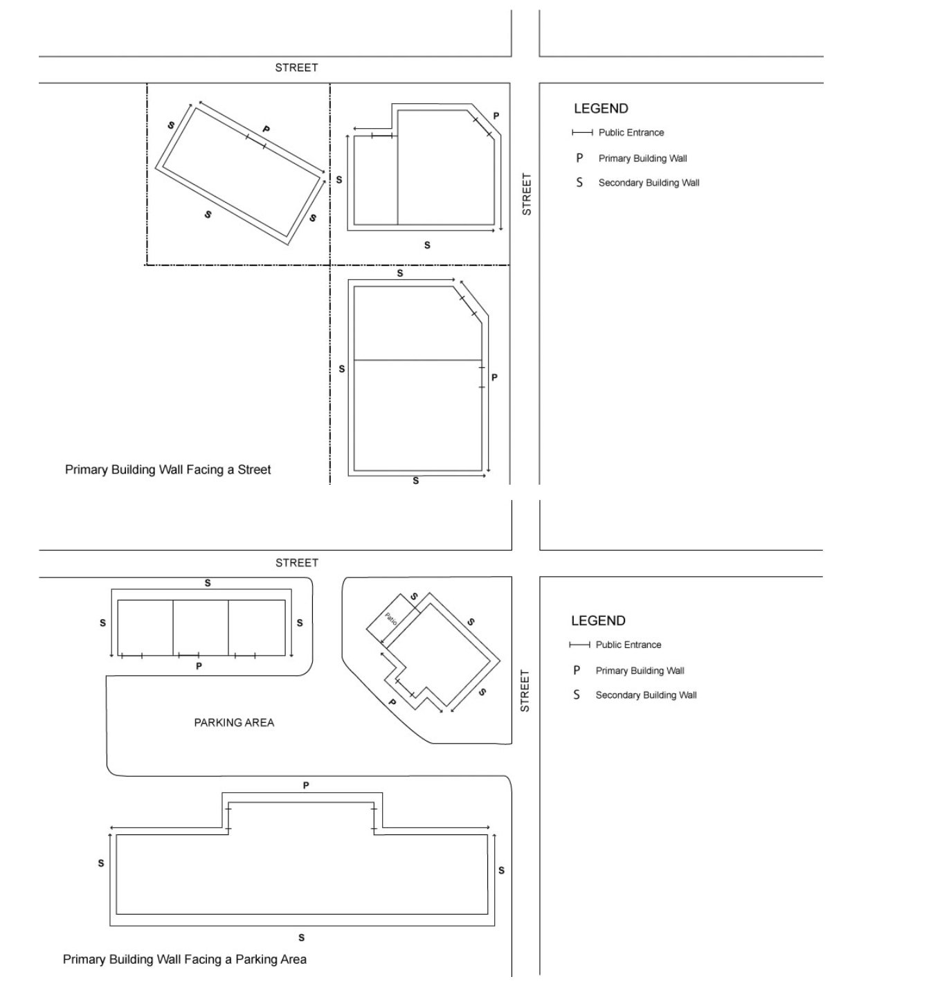
"primary building wall" means any exterior building wall that forms part of a façade that contains a public entrance and faces, or is oriented to, a street or a parking area on the same parcel as illustrated in Sign Illustration 2, with the exception that corner sites facing public streets can have two primary building walls not withstanding one façade may not contain a public entrance.
Primary and Secondary Building Wall
Subsection 13(108.1) and 13(122.1)
110
"private amenity space" means amenity space provided for the use of the occupants of only one unit.
111
"private condominium roadway" means an area of land that provides access to a parcel, and is contained within:
b
a bare land unit that is used for the purpose of accommodating a private roadway for access purposes in accordance with an easement agreement registered on it.
112
"private garage" means an Accessory Residential Building or a part of a main residential building which accommodates the storage or shelter of vehicles and includes a carport.
114
"public area" means the floor area of a use that allows access to the public, but does not include washrooms, hallways accessing washrooms or entrance vestibules.
116
"rear property line" means the property line opposite to and farthest from the front property line, or in the case of an irregular parcel, the rear property line is established by drawing a line the maximum distance from the front property line that:
c
runs parallel to the front property line, or, if the front property line is a curved line, runs parallel to the straight line between the two end points of the curve of the front property line.
117
"rear setback area" means an area of a parcel defined by the rear property line, the side property lines that intersect with the rear property line, and a line parallel to the rear property line measured at the minimum depth of the setback area required by the District.
117.1
"receiving parcel" means the parcel, comprising the area of the Municipal Historic Resource, that will receive the transfer of motor vehicle parking stalls from a transferring parcel.
118
"recessed balcony" means a balcony that is enclosed on at least two sides other than by a railing, balustrade or privacy wall.
119.2
"research and development" means the process of creating or improving products and services by way of information obtained through experimental qualitative and quantitative testing for industries such as, but not limited to, pharmaceuticals, bio-technology, computer software, medical instrumentation, aerospace and electronics manufacturers.
120
"residential district" means any of the land use districts in the low density residential districts and the multi-residential districts and the H-GO District.
121.3
"scramble parking" means a parking area where the motor vehicle parking stalls are not assigned to individual users or vehicles and where access is available to vehicles for periods no longer than four hours at a time.
122.1
"secondary building wall" means any exterior building wall that is not a primary building wall as illustrated in Sign Illustration 2.
123
"setback area" means the area of a parcel between the property lines and lines parallel to the property lines at a distance equivalent to the minimum depth from each respective property line as required by the District.
b
contains more than one commercial use, being primarily retail and personal service, with shared parking; and
126
"side setback area" means an area of a parcel defined by any side property line and a line parallel to that side property line measured at the minimum depth of the setback area required by the District and terminating where that line meets the front setback area and the rear setback area.
130
"skateboard and sports ramp" means structure(s) that provide a surface upon which an individual may use or operate a skateboard, bicycle, scooter, roller skates or other similar devices. Skateboard and sports ramp structures may include re-purposed furniture or other skateable or bikeable above grade surfaces, but does not include at-grade surfaces such as, but not limited to, soil, grass, wood or concrete.
133
"storey" means the space between the top of any floor and the top of the next floor above it, and if there is no floor above it, the portion between the top of the floor and the ceiling above it but does not include a basement.
a
any public road, including the boulevards, sidewalks and improvements, but excluding a lane, bridge or walkway; or
135
"street-oriented multi-residential building" means a Multi-Residential Development where all of the buildings in the development include the following characteristics:
a
the façade of the main residential building on the floor closest to grade facing a street is comprised of units or commercial multi-residential uses, and may only include the following additional elements:
b
units and commercial multi-residential uses located at grade with an exterior wall facing a street that provide the following:
d
the façade of commercial multi-residential uses located on the floor closest to grade, and facing a street, provides windows with unobscured glass that:
136.1
"top of bank" means the natural transition line or upper natural topographical break at the top of a valley, or at the top of a channel that contains a watercourse, between a slope where the grade exceeds 15.0 per cent and the adjacent upper level area where the grade is less than 15.0 per cent, and where area that is less than 15.0 per cent in slope is at least 15.0 metres wide.
a
the height measured from the highest vertical extension of a Wind Energy Conversion System -Type 1 to its base at grade or to the height equivalent to its mount on a building; and
b
the height measured from the highest vertical extension of a Wind Energy Conversion System - Type 2 to its base at grade.
136.3
"transferring parcel" means a parcel, comprising the area of the Municipal Historic Resource, that will transfer unused motor vehicle parking stalls to a receiving parcel.
ii
all mechanical rooms, offices and other spaces that support the use and can be accessed without leaving the building or using a common internal corridor; and
140
"visitor parking stall" means a motor vehicle parking stall intended only for the use of visitors to Dwelling Units and Live Work Units.
142
"waste" means a solid or liquid material or product or combination of them that is disposed of or stored prior to transportation to the final disposal location. Waste that includes any amount of recyclables is considered waste.
a
the building setback is not greater than 0.1 metres from the side property line for any portion of a building that is recessed 0.6 metres or greater from the front façade or the rear façade of the building and is setback less than 1.2 metres from the side property line;
b
the wall at the shared side property line is constructed of maintenance-free materials and there is no overhang of eaves onto an adjacent parcel; and
Methods
b
trees in a setback area or a landscaped area are always rounded up to the next higher whole number;
c
shrubs in a setback area or a landscaped area are always rounded up to the next higher whole number; and
e
where determining the contextual building setback and the number arrived at is less than zero metres, the contextual building setback is zero metres.
a
the distance to a BRT station from a development is measured in a straight line from the closest edge of the station to the closest point of the parcel, or all the parcels, containing the subject development;
b
the distance to a LRT platform from a development is measured in a straight line from the closest edge of the platform to the closest point of the parcel, or all the parcels, containing the subject development; and
c
the distance to primary transit service from a development is measured in a straight line from the closest edge of public right-of way containing the primary transit service to the closest point of the parcel, or all the parcels, containing the subject development.