Bylaw test
PART 6: MULTI-RESIDENTIAL DISTRICTS
Division 1: General Rules for Multi-Residential Land Use Districts
Projections Into Setback Areas
General Landscaped Area Rules
Specific Rules for Landscaped Areas
Planting Requirements
Landscaped Area Reductions — Multi-Residential Development
Street-Oriented Multi-Residential Landscaping Option
Enhanced Landscaping Option
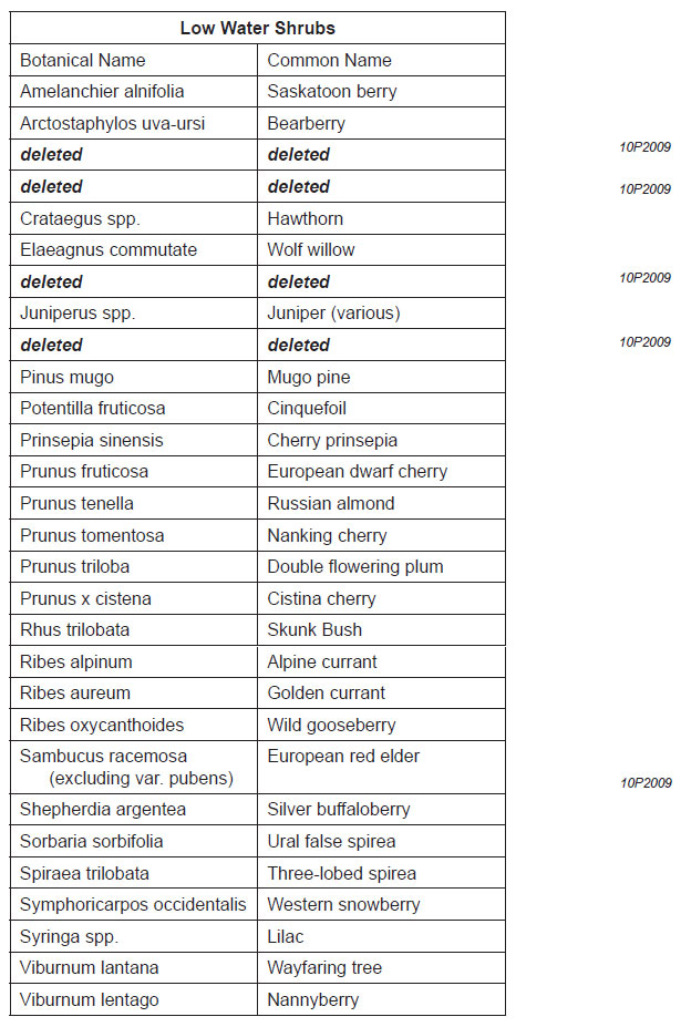
Low Water Landscaping Option
Table 3: Low Water Trees
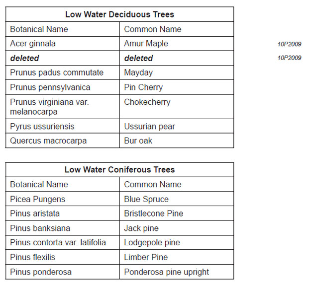
Table 4: Low Water Shrubs
Amenity Space
Motor Vehicle Parking Stall Requirements
Reduction for Transit Supportive Multi-Residential Development
Parking Maximums Close to LRT Stations
Accessory Residential Buildings
Driveway Length and Parking Areas
Recycling Facilities
Mechanical Screening
Visibility Setback
Retaining Walls
Fences
Skateboard and Sports Ramps
Single Detached, Semi-Detached, Duplex Dwellings, Secondary Suites and Backyard Suites
Commercial Multi-Residential Uses
Division 2: Multi-Residential – Contextual Grade-Oriented (M-CG) (M-CGd#) District
Purpose
Permitted Uses
Discretionary Uses
Rules
At Grade Orientation of Units
Setback Area
Building Setbacks
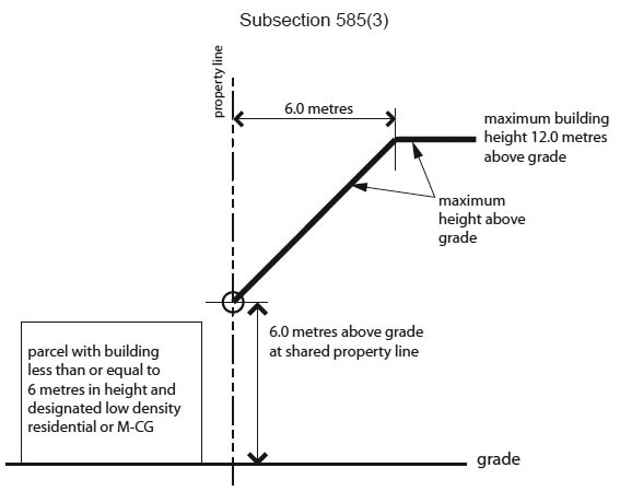
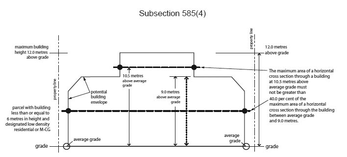
Building Height and Cross Section
Illustration 3: Building Height and Cross Section in the Multi-Residential Contextual Grade Oriented (M-CG) District
Division 3: Multi-Residential – Contextual Low Profile (M-C1) (M-C1d#) District
Purpose
Permitted Uses
Discretionary Uses
Rules
Setback Area
Building Setbacks
Building Height and Cross Section
Illustration 4: Building Height and Cross Section in the Multi-Residential Contextual Low Profile (M-C1) District
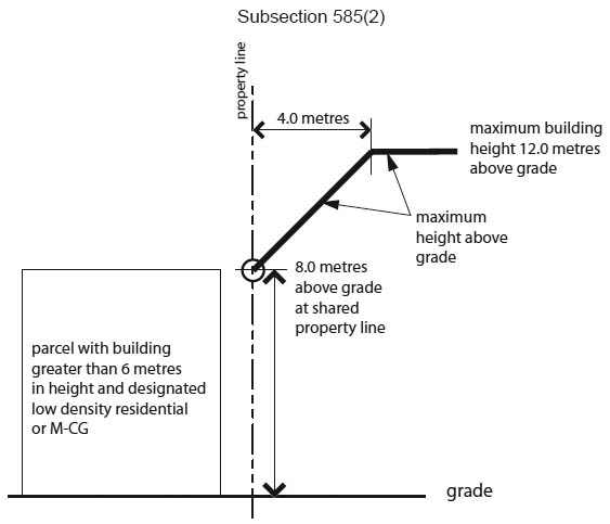
Subsection 594(2)
.jpg)
.jpg)
.jpg)
Division 4: Multi-Residential – Contextual Medium Profile (M-C2) (M-C2f#d#) District
Purpose
Permitted Uses
Discretionary Uses
Rules
Floor Area Ratio
Setback Area
Building Setbacks
Building Height and Cross Section
Illustration 5: Building Height and Cross Section in the Multi-Residential Contextual Medium Profile (M-C2) District
.jpg)
.jpg)
.jpg)
Division 5: Multi-Residential – At Grade Housing (M-G) (M-Gd#) District
Purpose
Discretionary Uses
Setback Area
Building Setbacks
Amenity Space
Division 6: Multi-Residential – Low Profile (M-1) (M-1d#) District
Purpose
Permitted Uses
Discretionary Uses
Setback Area
Building Setbacks
Building Height
Illustration 6: Building Height in the Multi-Residential Low Profile (M-1) District
.jpg)
.jpg)
Division 7: Multi-Residential – Medium Profile (M-2) (M-2f#d#) District
Purpose
Permitted Uses
Discretionary Uses
Floor Area Ratio
Density
Setback Area
Building Setbacks
Building Height
Illustration 7: Building Height in the Multi-Residential Medium Profile (M-2) District
.jpg)
.jpg)
Division 8: Multi-Residential – High Density Low Rise (M-H1) (M-H1f#h#d#) District
Purpose
Permitted Uses
Discretionary Uses
Floor Area Ratio
Density
Setback Area
Building Setbacks
Building Height
Rules for Commercial Multi-Residential Uses
Division 9: Multi-Residential – High Density Medium Rise (M-H2) (M-H2f#h#d#) District
Purpose
Permitted Uses
Discretionary Uses
Maximum Floor Area Ratio
Density
Setback Area
Building Setbacks
Building Height
Rules for Commercial Multi-Residential Uses
Division 10: Multi-Residential – High Density High Rise (M-H3) (M-H3f#h#d#) District
Purpose
Permitted Uses
Discretionary Uses
Floor Area Ratio
Density
Setback Area
Building Setbacks
Building Height
Rules for Commercial Multi-Residential Uses
Division 11: Multi-Residential – Low Profile Support Commercial (M-X1) (M-X1d#) District
Purpose
Permitted Uses
Discretionary Uses
Setback Area
Building Setbacks
Building Height
Illustration 8: Building Height in the Multi-Residential — Low Profile Support Commercial (M-X1) District
.jpg)
.jpg)
Rules for Commercial Multi-Residential Uses
Division 12: Multi-Residential – Medium Profile Support Commercial (M-X2) (M-X2f#d#) District
Purpose
Permitted Uses
Discretionary Uses
Floor Area Ratio
Density
Setback Areas
Building Setbacks
Building Height
Illustration 9: Building Height in Multi-Residential — Medium Profile Support Commercial (M-X2) District
.jpg)
.jpg)