Anderson Road S.E. pathway project
Update – May 2026
After reviewing community feedback, we have decided to pause the project to take a closer look at our options. This additional time will allow us to discuss ways to better connect community destinations and enhance accessibility in public spaces before determining next steps. We appreciate the feedback shared to date and will continue to provide updates as more information becomes available.
Overview
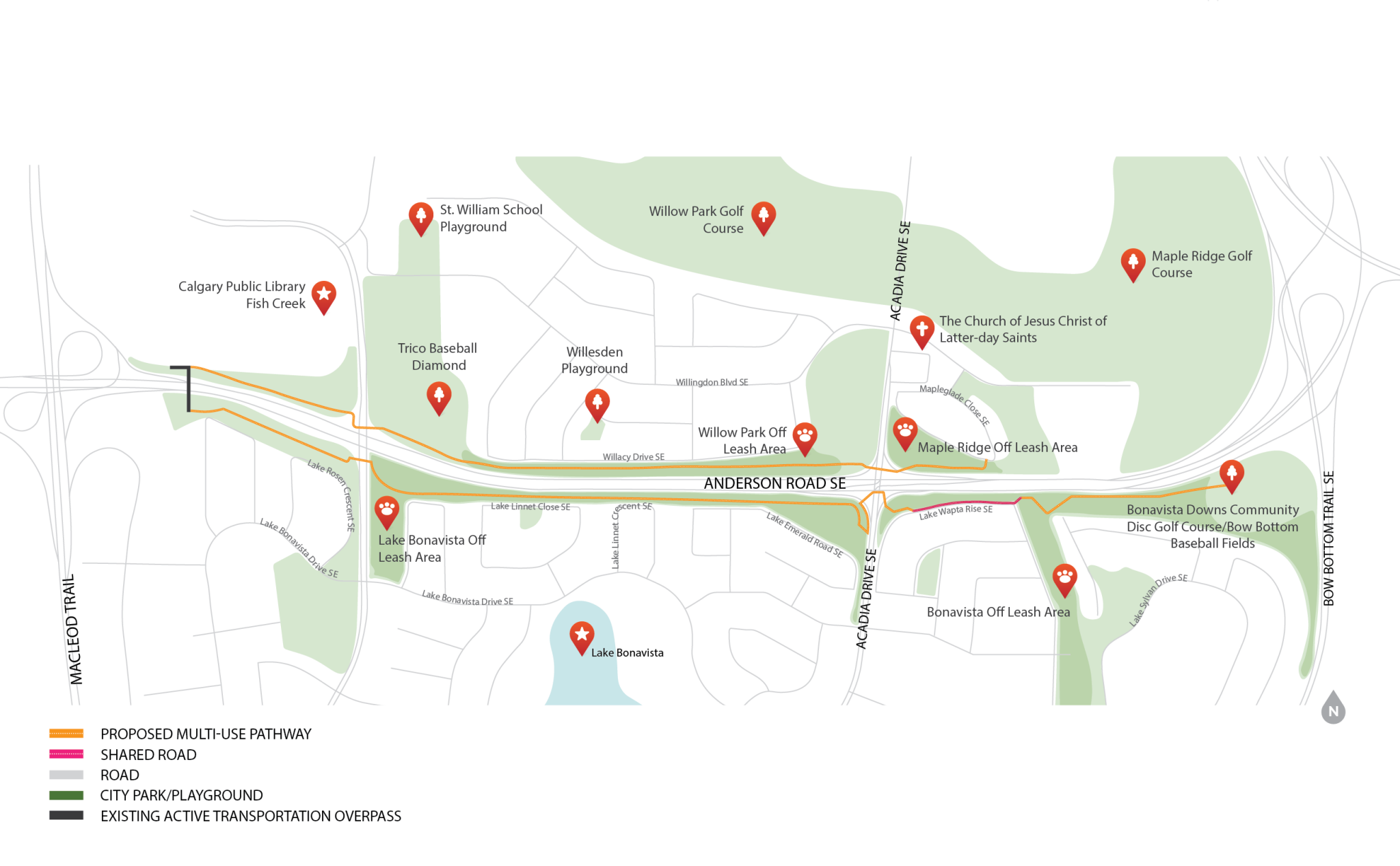
We are creating a safer, more accessible connection along Anderson Road S.E. by closing a key gap in Calgary’s pathway network. We are designing a new multi‑use pathway between Macleod Trail and Mapleglade Close S.E. This pathway is for everyone: people walking, biking, using mobility devices, pushing strollers, jogging, dog‑walking, and more. Closing this gap will also make it easier to reach places like Fish Creek Library, Trico Centre, St. William School, and local parks and recreation spaces.
We are currently in the design stage, with construction on the north side planned for later this year.
Project map
Contact us
For more information, please email us or contact 311.
Image gallery
Frequently asked questions
Why is the City building a pathway along Anderson Road?
The City is building a pathway along Anderson Road to close a major gap in the pathway network and improve east–west connections for people walking, wheeling, and biking. This pathway links several important community destinations, and a continuous pathway will make it easier and safer for people of all ages and abilities to reach them.
The pathway will provide a more direct connection to places such as the Fish Creek Library, Trico Centre and its baseball diamonds, St. William School, local playgrounds, off leash areas, and the Bonavista Downs disc golf course and ball fields, along with other destinations throughout the community.
Why is this the first time I’m hearing of this project?
We’re at the beginning of our community outreach. We’ve shared initial information with adjacent residents and local community associations, and we’ll continue to provide updates as the project moves forward. As part of this outreach, signs will be installed in the parks to direct people to the project webpage.
This spring, we’ll be visiting the off‑leash parks to speak with community members about how they access the area and whether there are small details we can incorporate to make the pathway work well for everyone.
Will the pathway go through the Willow Park off‑leash dog area?
The pathway location was chosen through a detailed feasibility analysis that considered many factors, including impacts to the off‑leash area, safety, accessibility, grades, constructability, and cost. After balancing all of these elements, the proposed alignment was identified as the most workable option.
Experience in other parts of Calgary shows that pathways and off‑leash areas can successfully share green spaces. The pathway is expected to welcome more dog walkers while also providing a family‑friendly route to many nearby destinations.
Is mixing walking, wheeling, biking, and off‑leash dogs safe?
In established communities, shared spaces like pathways and off-leash areas offer unique opportunities for people and pets to enjoy the outdoors together. While there are limited locations to place these amenities, Calgary’s experience has shown that residents can successfully share these areas and foster a positive environment for all users.
Across the city, from Parkland Boulevard SE and 28th Street SE to the Inglewood River Promenade, pathways and off-leash areas often coexist, helping us learn how these spaces can function safely and inclusively. To support this shared use, clear signage will be placed on pathways to let cyclists and other users know when they are entering a “shared space,” promoting awareness and cooperation among everyone enjoying the community.
Why not route the pathway on existing streets through the community?
The project team explored Willacy Drive as a possible route and reviewed several options, including shifting the south curb to create space for a roadside path, upgrading the existing sidewalk, and designating the street as a shared space for both bikes and cars.
Relocating the curb was found to be infeasible because the remaining road width would not allow for emergency access while keeping parking on one side of the street. Placing the pathway in the south boulevard was also ruled out, as it would require removing mature trees and working within their root zones, which the project aims to avoid.
Using Willacy Drive as a shared street would reduce the amount of new construction, but it would not improve safety for all users. Accessibility is also a key goal for this project, and the existing sidewalk is too narrow for two strollers or wheelchairs to pass safely.
Will the dog park be reduced or eliminated?
The project does not include removing off‑leash areas. The design will maintain access for all people using the space currently as well as make it more accessible for others, including seniors, people with mobility challenges, people using strollers, and others who may find the current conditions difficult.
Could fencing be added to separate the pathway from the off‑leash area?
Relocating the existing fence and providing an additional fence were considered when determining the preferred path location. To avoid reducing the size of the off-leash area and to provide continuous accessibility for path users, a new fence was not included in this design.
What about safety at intersections crossings?
All intersections are being reviewed as part of the project’s safety assessment. The design will follow current City standards for pathway and intersection safety. Upgraded measures, like rectangular rapid flashing beacons, are all being considered where found to be warranted.