Discovery Ridge Dam safety
Discovery Ridge Dam Safety
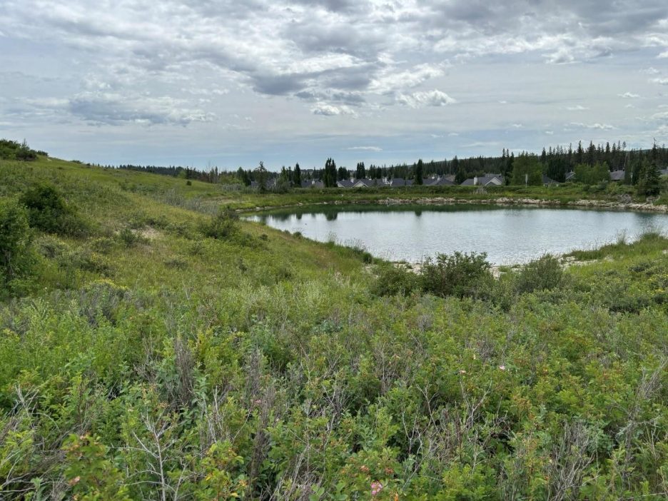
Addressing the long-term risks of the Discovery Ridge Dam, protecting residents and homes in the community.
Project background
As part of The City’s Pond Maintenance and Dam Safety Programs, engineering and condition assessments were completed on the Discovery Ridge Dam. The assessments showed that a portion of the dam’s embankment had potential slope stability risks and a dam safety review outlined several additional deficiencies.
In 2024 we undertook interim actions to address the known risk, while we develop a long-term plan for the dam, including:
- Clearing debris from the outlet of the pond, to reduce the water level.
- Installing real time pond level monitoring equipment.
- Increasing the frequency of groundwater monitoring in addition to ongoing routine engineering inspections.
- Extending the outlet pipe, permanently lowering the water level.
The City has made the decision to remove the dam to address risks to public safety. Understanding this is a valued space in the community, it will be reimagined as a park space where water will flow through it in a natural way.
Project status - Spring 2026
We have developed two concept designs that will remove the existing dam and replace it with a natural ravine or wetland to move spring water through the same area. The surrounding area would remain a natural area, supporting biodiversity in the community. Public engagement on design concepts was completed in May 2026, ahead of moving into the next design phase.

Dam: a barrier constructed for the purpose of storing, diverting, or retaining water. Dams can be created from various materials including concrete, metal, or earth. The dam at Discovery Ridge is created from earth.
Trap Low: a depressed or naturally low area where water pools.
Spillway: a controlled area where excess water can flow out of the trap low when the water level exceeds the safe level.
Did you know?
This body of water was originally created as a water source for agricultural uses in the 1950s. It is not considered a stormpond as no storm pipes enter the pond and the water source is a natural groundwater spring with small amounts of local overland drainage.
Project timeline
2024
- Initial dam safety review completed
- Interim actions taken to lower trap low’s water level
2025
- Concept design begins
- Community information and sharing session (summary available here)
Q1 2026
- Technical information session and Q&A (summary available here)
- Concept design complete
- Community Engagement completed, May 2026
Later in 2026, 2027-2028
- Detailed design, regulatory approvals
2027 – 2030 budget cycle
- Construction
Contact
Contact the project team
For more information about dams in Alberta visit Alberta.ca - About dams
Frequently asked questions
Why is The City removing the dam?
We are removing the dam because the 2024 Independent Dam Safety Review reported the dam slope doesn’t meet stability requirements, posing a danger to the community and requiring immediate attention.
Why can’t the existing dam be repaired?
Keeping the dam would require extensive upgrades and construction with no guarantee of preventing dam failure in the future. This is a risk to the community.
To comply with regulatory and industry standards, the water level would need to be lowered substantially, which would negatively impact the surface area and aesthetics. In addition, there is insufficient physical space to install the additional structural support required on the east side of the dam.
What will replace the dam?
We are working on designs that will remove the existing dam and replace it with a natural channel or wetland to move spring water through the same area. The surrounding area would be a natural, or wild park area, supporting biodiversity in the community.
When was the Dam Safety Review completed?
The Dam Safety Review was completed in 2024. This report is what led to the interim actions taken by the City in spring 2024, including lowering the water levels, extending the outlet pipe and clearing debris around the existing outlet.
Since then, we have lowered the dam safety risks to the community by installing real-time pond level monitoring equipment, groundwater monitoring, and completing regular engineering inspections as well as analyzing those results.
Will the community have a chance to provide input?
Yes, the community will have an opportunity to provide input on the proposed designs in early 2026.
What is the timeline for this project?
We are currently in the early stages of designs and we expect to have these completed in early 2026. When this phase is completed, we will ask the community for input before moving into a more technical design phase and execution.
What impacts will this project have on the existing environment and wildlife in the area?
Environmental assessments are being completed to inform the design of the project.