50 Avenue S.W. improvements
Project update – February 2026
Phase 2 construction expected in Spring 2026
The City of Calgary shifted the start of construction on Phase 2 of the 50 Avenue Improvements from summer 2025 to spring 2026. The new schedule will minimize impacts on the area by finishing the work in one construction season.
This phase includes a new signal light at 20 Street S.W., extending the multiuse pathway along the southside of 50 Avenue from 19 Street to connect with the existing pathway at 22 Street and replacing the pavement on 50 Avenue between Crowchild Trail and 14a Street.
We will complete rectangular rapid flashing beacon (RRFB) adjustments at 21a Street S.W. during spring break. Construction onthe new signal at 20 Street S.W. starts in early spring 2026. Roadway construction will get underway in early spring 2026 and wrap up in fall 2026.
Project timeline
- Engagement: 2017
- Phase 1 Detailed design: Complete
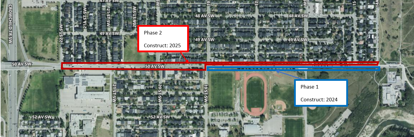
- Phase 1 Construction: July 2024 to September 2024
- Phase 2 Detailed Design: Fall/Winter 2025
- Phase 2 Construction: Construction start Spring 2026
Questions?
- Contact the project team at 50avenueSW@calgary.ca or call 311.
Project overview
We are completing the 50 Avenue S.W. Improvements in phases. The project will include a permanent multiuse pathway from 14a St S.W. to 22 St S.W. and connect with The City of Calgary’s expansive 5A network.
The new pathway will replace the existing sidewalk along the south side of 50 Avenue, with redesigned on-street parking between 19 St S.W. and 22 St S.W.
The project will also include curb extensions, a new traffic signal and repaving of 50 Avenue SW to further enhance roadway safety.
Project delivery
50 Avenue S.W. Improvements Phase 2 (from 22 Street S.W. to 19 Street S.W.)
50 Avenue S.W. Improvements Phase 2
(from 22 Street S.W. to 21 Street S.W.)
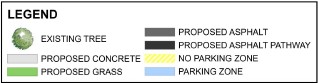
NOTES:
- Crosswalks, line painting and markings shown are for conceptual purposes only. Road marking and crosswalks may differ in the final product.
- Proposed roadway and intersection improvements shown may be subject to change, resource permitting. The final product may be different from what is shown.
- Colours of improvements are shown for map visibility, actual colours of improvements will vary.
50 Avenue S.W. Improvements Phase 2
(from 21 Street S.W. to 20 Street S.W.)
NOTES:
- Crosswalks, line painting and markings shown are for conceptual purposes only. Road marking and crosswalks may differ in the final product.
- Proposed roadway and intersection improvements shown may be subject to change, resource permitting. The final product may be different from what is shown.
- Colours of improvements are shown for map visibility, actual colours of improvements will vary.
50 Avenue S.W. Improvements Phase 2
(from 20 Street S.W. to 19 Street S.W.)
NOTES:
- Crosswalks, line painting and markings shown are for conceptual purposes only. Road marking and crosswalks may differ in the final product.
- Proposed roadway and intersection improvements shown may be subject to change, resource permitting. The final product may be different from what is shown.
- Colours of improvements are shown for map visibility, actual colours of improvements will vary.
The project is being delivered in two phases:
Phase 1 – Completed in 2024
- Removed adaptive roadway on south side of 50 Ave S.W. from 14a St S.W. to 19 St S.W.
- Installed new raised multiuse pathway in place of adaptive roadway
Phase 2 – Anticipated start Spring 2026
- Extending the multiuse pathway from 19 St S.W. to 22 St S.W.
- Curb extensions at key locations along the 50th Ave S.W. to calm traffic and shorten crossing distances
- A new traffic signal at the 20 St S.W. intersection
- Repaving on 50 Ave from 14a St to Crowchild Trail S.W.
he Phase 2 detailed design is complete, with the focus on extending the multiuse pathway with redesigned parking on the south side of 50 Avenue S.W., installing curb extensions at key intersections and a new traffic signal at 20 Street.
Related links
About the project
50 Avenue S.W. provides access to the residential communities of Altadore, Garrison Woods and North Glenmore Park. It also connects people to schools and destinations like Glenmore Athletic Park, River Park and Sandy Beach. As a result, it is well-used by people who walk, bike, take transit and drive.
In 2017, The City of Calgary conducted a transportation corridor study of 50 Avenue S.W. between Crowchild Trail and 14a Street S.W. The final recommended plan for 50 Avenue S.W. included a multi-use pathway on the south side of 50 Avenue S.W. along with various other improvements. Funding for construction was not available at that time.
In 2020, The city constructed a temporary adaptive pathway between 19 St and 14a Street S.W. to allow for cyclists to use the south side of 50 Avenue S.W.
The City of Calgary's Adaptive Roadway Program installed infrastructure on 50 Avenue S.W. as part of its efforts to provide more space for walking, cycling, and other activities during the COVID-19 pandemic. This specific installation, involving the closure of the eastbound parking lane between 14a Street S.W. and 19 Street S.W., was implemented to accommodate increased pedestrian and cyclist traffic along the corridor.
Information gathered from the 2017 Engagement, operational history of the temporary adaptive pathway and current plans for the Glenmore Athletic Park were used to develop the option being constructed today.
Alignment with Council priorities
This project supports Calgary’s Council priorities by:
- Enhancing safety and accessibility: Off-street wheeling lanes improve safety by providing bicycles, scooters, skateboards and other wheeling users a separate space from vehicles.
- Promoting social equity: Off-street wheeling lanes offer cost-effective, healthy, and inclusive transportation options, enhancing citywide accessibility goals and equitable access to transportation.
- Addressing climate goals: Encouraging wheeling and walking reduces greenhouse gas emissions, contributing to Calgary’s climate resilience efforts.
- Strategic infrastructure investments: This initiative is part of a broader strategy to invest in Calgary’s infrastructure, improving safety, reducing congestion, and fostering a healthier community.
Under the Pathways and Bikeways (5A) program, council approved investing $59 million to improve existing connections by closing the gaps in our existing network.