Revitalize 8 Street SW Project
Revitalize 8 Street S.W.
The City is investing in the future by modernizing 8th Street S.W into a vibrant urban destination and community connector. The project will support the overall success of Calgary’s Greater Downtown Plan by transforming the street into a welcoming, pedestrian-focused corridor with comfortable gathering spaces, dedicated walking and wheeling paths, enhanced landscaping, and other infrastructure improvements.
Project Update - April 2026
Winter is making a comeback in Calgary, but that isn’t slowing us down on construction on the 8 Street S.W. improvements! Crews plan to continue hydrovac work between 5-8 Avenue S.W. over the next several weeks, and mobilization on the northwest side of 8 Street S.W. begins this month to start work on the pathway improvements.
For more detailed information about this work, view our construction timetable.
Stay connected
To receive project communications and construction updates, sign up for our newsletter.
-
Support Local Downtown
Show some love to our local 8 Street S.W. businesses! Visit the Support Local Downtown page to learn how you can support businesses along the corridor that are being affected by construction.
Project timeline
Construction timetable
| Location | Timeframe | Details |
|---|---|---|
|
Early April to early July |
To complete the nearby pathway upgrades, the entrance to Lot 6 will temporarily be moved. The new entrance to the lot will be located slightly further north than the existing entrance, maintaining parking access during construction work. |
|
|
Bow River Pathway to 3 Avenue S.W. |
Early April to early July |
The pathway on the west side of 8 Street S.W., north of 3 Avenue S.W., and the connection to the Bow River Pathway will be temporarily closed to complete sidewalk upgrades. Access to the Bow River Pathway will be maintained via the east sidewalk along 8 Street S.W. |
| 5 to 8 Avenue S.W. | Beginning the week of April 13 for approximately 2 weeks | Short-term curbside lane closures will be needed on the east and west sides of 8 Street S.W. for hydrovacing work. Bidirectional traffic will be maintained during the closures. |
Project scope
The Revitalize 8 Street S.W. project spans approximately 1.5km, from 2 Avenue S.W. (north end) to 17 Avenue S.W. (south end). 8 Street is one of the few downtown streets that provides a direct north-south connection between the Beltline and downtown Calgary. It links the 17 Avenue Main Street and adjacent communities to the Bow River along the west edge of our downtown.
We are currently funded to move forward on construction for the Downtown Segment (2 to 10 Avenue S.W.), and will be implementing interim safety improvements between 10 and 12 Avenue S.W.
8th Street overview map
Click to enlarge map
Addition of Water Utility Improvements
To avoid the need for additional water utility upgrades in the future, The City is proactively addressing the water infrastructure in this area and will complete this work at the same time as the 8 Street S.W. project to reduce disruptions. This will improve the reliability and resilience of our growing city’s water system, as well as reduce the risk of future service disruptions and emergency repairs. We expect to complete these system improvements between 4-6 Avenue S.W. in 2026 and 6-8 Avenue S.W. in 2027.
Investment
The projected investment for the 8 Street S.W. Revitalization project is estimated to be $30M. $20.5M was generously provided by the Government of Canada through the Canada Community-Building Fund, with the remaining funding provided through The City’s capital reserves.
-
Eight of the twenty-one approved office-to-residential conversions are happening along or near 8th Street S.W.? Learn more about the Downtown Office Conversion Incentive Program.
Project benefits
The Revitalize 8 Street S.W. project will:
- Enhance accessibility for all users, including pedestrians, cyclists, transit riders, and drivers, with dedicated and protected walking and wheeling paths.
- Improve connectivity to surrounding communities, parks, natural areas, and transit, enhancing key east-west connections downtown, such as Stephen Avenue.
- Create comfortable and inviting gathering spaces that prioritize the pedestrian experience.
- Enhance landscaping and new green infrastructure to manage stormwater, provide shade and cooling, and increase biodiversity.
- Improve lighting and sight lines to promote safety.
- Provide comprehensive upgrades to replace aging infrastructure and improve the overall condition of the road.
The project is a foundational piece in The City's Greater Downtown Plan to establish a green network of tree-lined, people-focused streets that connect residents and visitors with parks, natural spaces and the river.
Block-by-block plan
2-5 Avenue S.W.
8 Street S.W. from 2-3 Avenue S.W. (200 Block Plan)
Click to enlarge plan
8 Street S.W. from 3 Avenue to 5 Avenue (300 to 400 Block Plan)
Click to enlarge plan
Please note that these illustrated drawings are intended for visual and conceptual purposes only and are subject to change based on technical requirements.
5-7 Avenue S.W.
8 Street S.W. from 5 Avenue to 7 Avenue (500 to 600 Block Plan)
Click to enlarge plan
Please note that these illustrated drawings are intended for visual and conceptual purposes only and are subject to change based on technical requirements.
7-9 Avenue S.W.
8 Street S.W. from 7 Avenue to 9 Avenue (700 to 800 Block Plan)
Click to enlarge plan
Please note that these illustrated drawings are intended for visual and conceptual purposes only and are subject to change based on technical requirements.
9-12 Avenue S.W.
8 Street S.W. from 10 Avenue to 12 Avenue (1000 to 1100 Block Plan)
Click to enlarge plan
Please note that these illustrated drawings are intended for visual and conceptual purposes only and are subject to change based on technical requirements.
Explore the design
Through the process of reviewing contemporary polices and standards, engaging with the public, and technical analysis of current site conditions, the project team defined several recommendations to guide the design of 8 Street S.W. These recommendations were provided to ensure that we deliver a safe, equitable, and beautiful street.
2023 Design Development Report
Updated February 15, 2024.
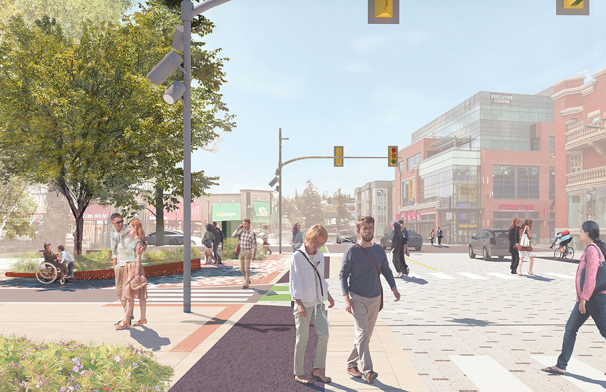
Creating a street for all
Click to view larger image. These are visionary illustrations subject to change.
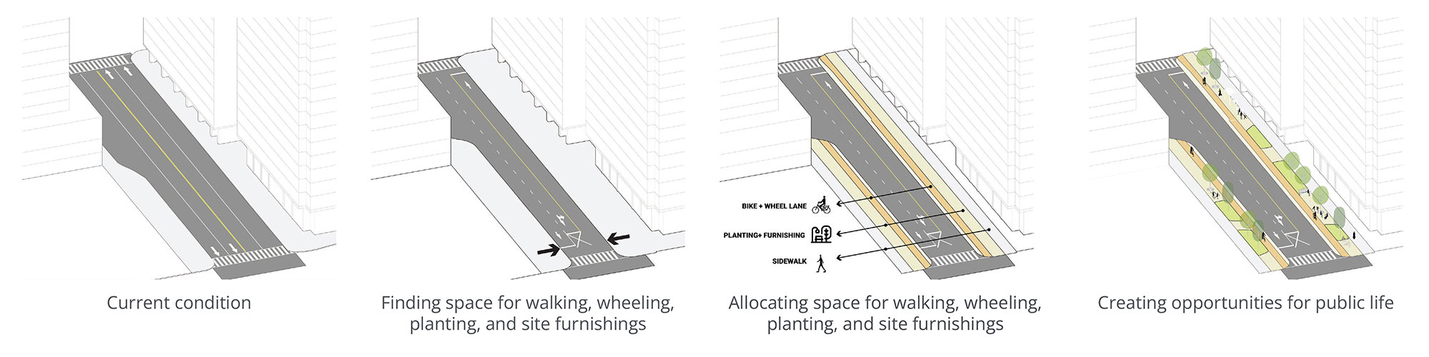
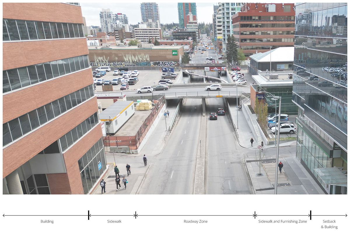
Existing Condition
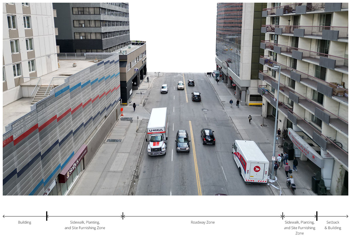
The existing image of downtown helps us to understand how 8 Street S.W. works and looks today. It is a street that is largely designed for vehicles, with little offered to make the environment inviting or pleasant for people. Examples of this are the lack of trees, vegetation, places to sit or rest, lighting, and space for people on bikes or scooters etc.
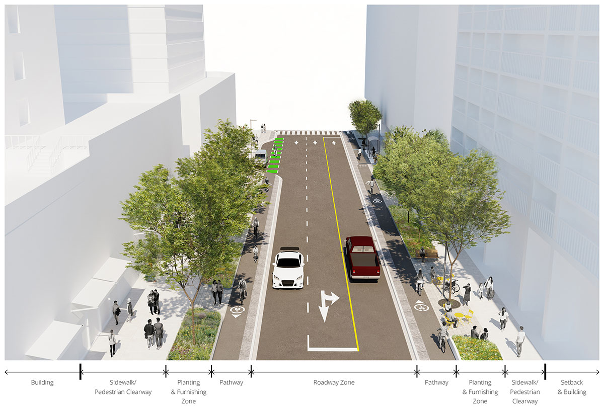
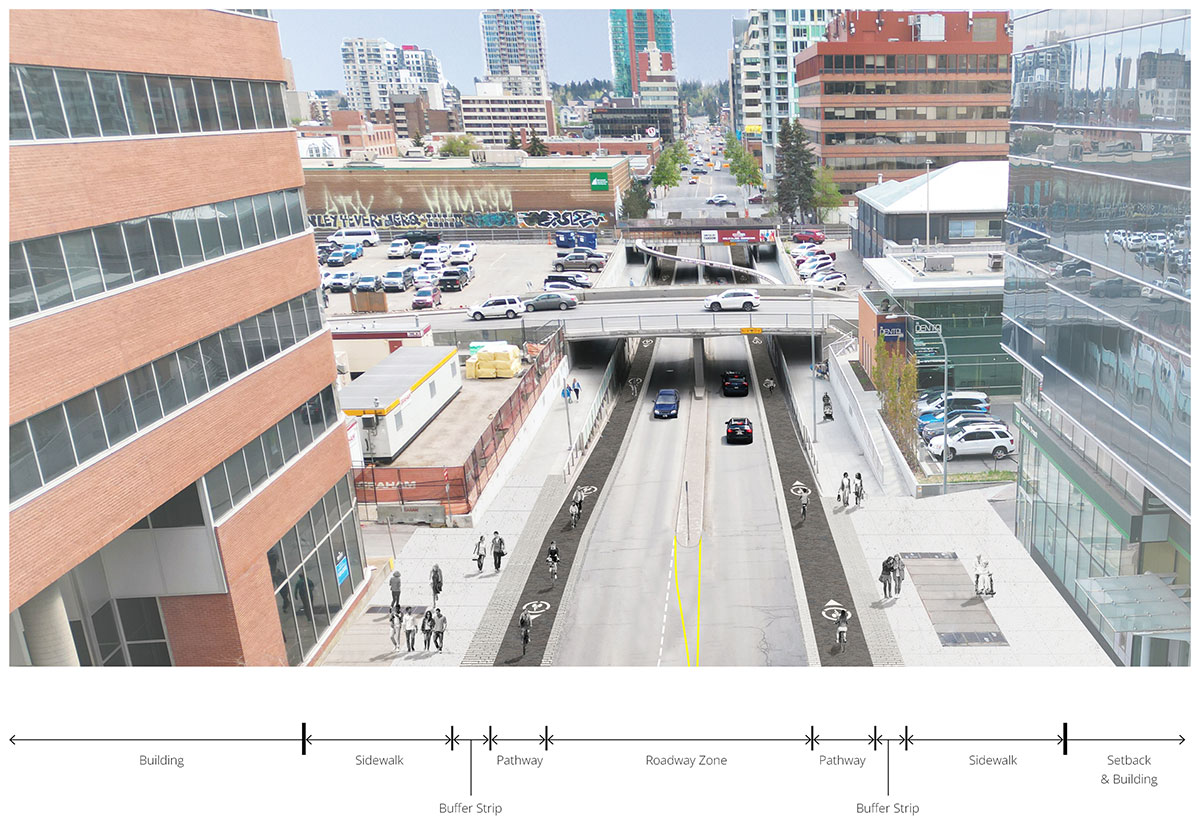
2023 Concept Design
Click to view larger image. These are visionary illustrations subject to change.
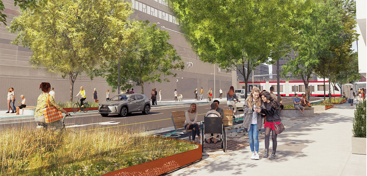
The illustration demonstrates how the design comes together to satisfy the Master Plan principles. 8 Street S.W. becomes a truly green network with protected cycling and wheeling facilities, generous space for planting of trees and other vegetation, places to sit and gather, and broad pedestrian zone free of obstacles. The design concept provides different planting conditions to best respond to varying conditions at grade (retail, restaurants, surface parking lots, blank walls etc.) and below grade (utilities).
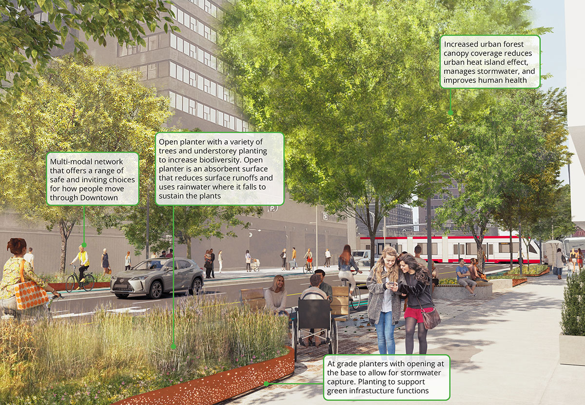
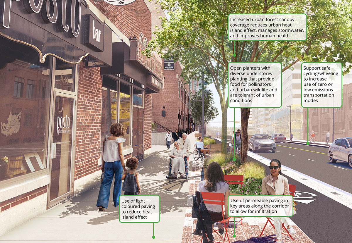
Building a green network
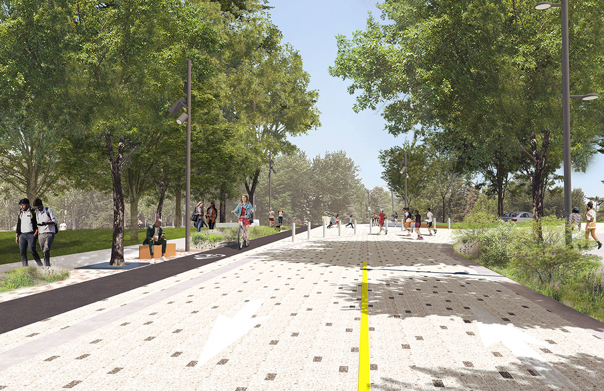
To Build a Green Network, the street is designed to support a multi-modal network, which means offering a range of safe and inviting choices for how people will move through the Downtown. The design increases the tree canopy offering a wide range of benefits including shade and cooling, enhancing walkability, beautification, improving mental health, traffic calming, and increasing property values of businesses and homes.
Priority is placed on creating optimal conditions for healthy trees to thrive. Increased soil volumes support larger, healthier plants and trees. Prioritizing soil volume over the quantity of trees in the street allows for the development of a larger tree canopy to support a comfortable and vibrant public realm. Ample soil volumes are provided through open planters, continuous trenches with wide tree grate openings, soil cells, as well as selecting tree species that are well-suited to site conditions.
Another strategy as part of the planting approach is to support biodiversity and a diverse planting palette, which means selecting native and resilient plant species that expand the range of both plants and animals (birds, pollinators etc.) that exist along 8 Street S.W.
Click to view larger image. These are visionary illustrations subject to change.
Click to view larger image. These are visionary illustrations subject to change.
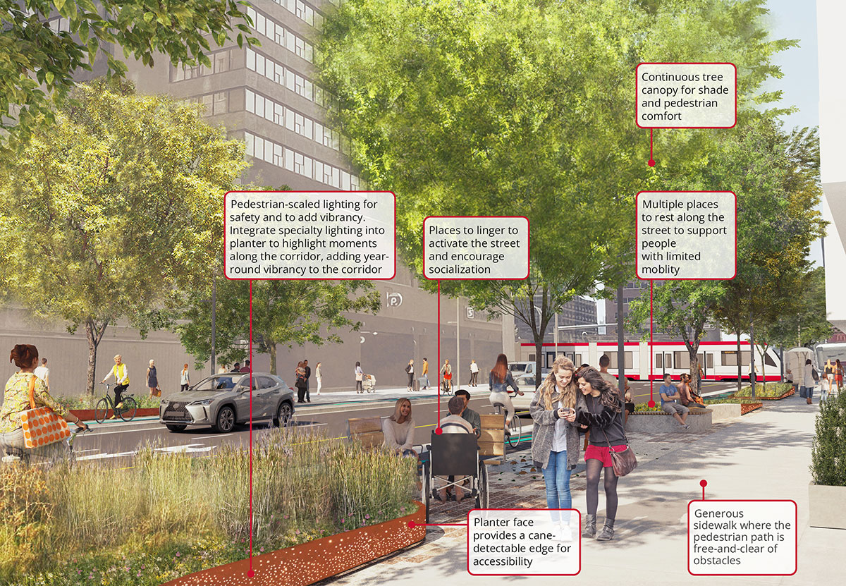
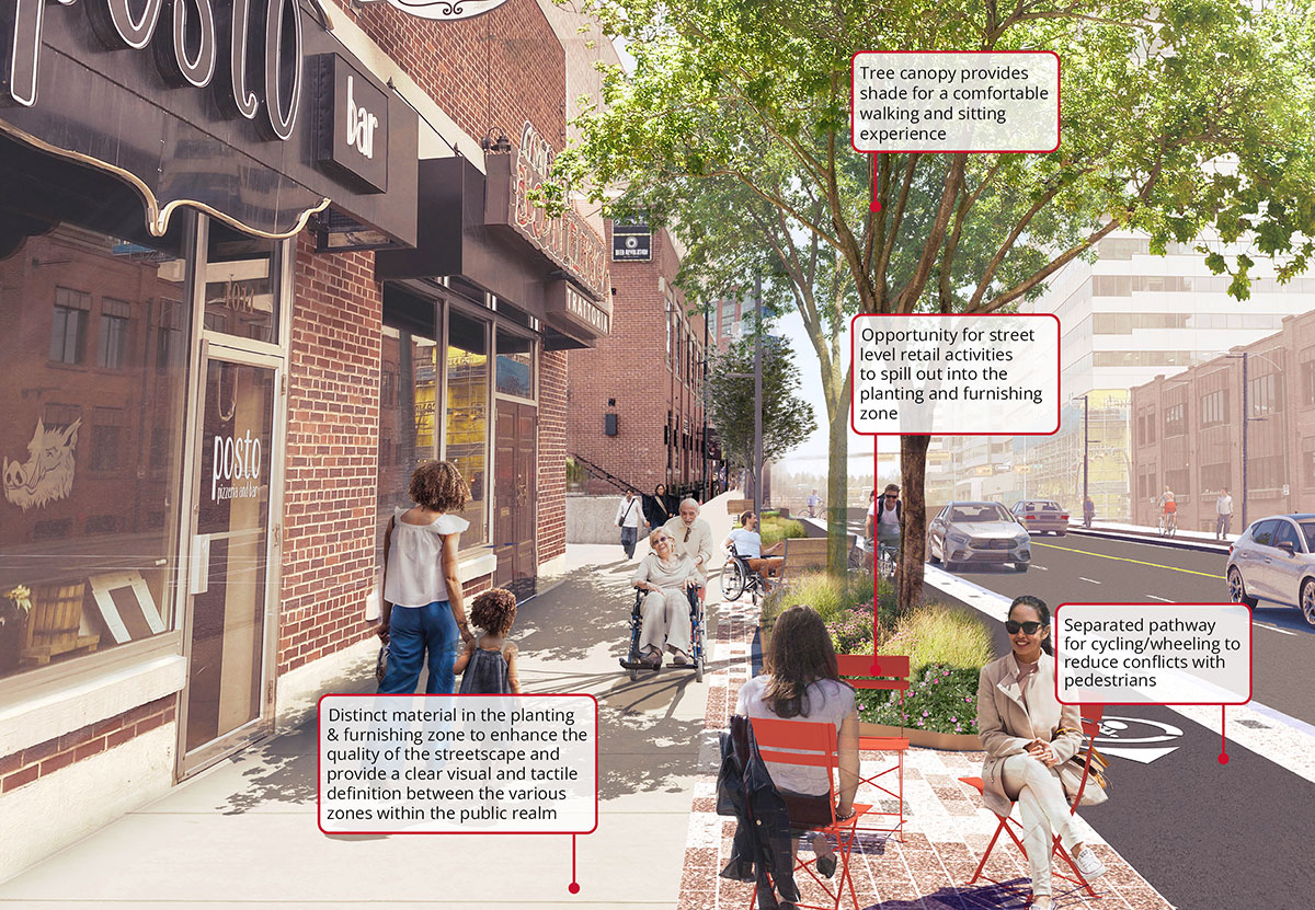
Creating opportunities for a public life
To Create Opportunities for Public Life, the design provides spaces along the street that support and are supported by the uses that take place on the ground floor of buildings along the corridor. Examples of this include outdoor seating in front of cafes and restaurants or increased greenery in front of areas that lack interest for people walking (blank walls).
As social beings, people enjoy meeting up with others, in either a casual or formal way. Bumping into a friend or neighbour when out for a walk is a simple joy and contributes to one’s fond memory of a place. The design supports this most human of behaviours by providing spaces for gathering. Related to this is the basic need to rest when walking along the street. The design provides comfortable seating at regular intervals to reinforce the strategies noted above and provide a welcome respite for those for whom walking is sometimes a chore.
Amenities (planters, seating, enhanced lighting, waste bins, bike racks etc.) are consolidated within the designated zone for planting and furnishing to maintain a clean and uncluttered streetscape. Improved lighting enhances the perception of safety and security and enriches the experience inviting people to continue to use the street after dark.
Click to view larger image. These are visionary illustrations subject to change.
Click to view larger image. These are visionary illustrations subject to change.
Underpass
Existing conditions
The existing image of the underpass section below helps us to understand how it works and looks today. The pedestrian area was improved in 2017 with upgrades to the finishes, lighting for pedestrians, feature lighting and public art features.
The four-lane roadway section was not improved or changed at that time. Since the bicycle lanes were not introduced in 2017, there has been some confusion as to where bicyclists should be cycling - on the sidewalk or on the roadway - causing conflicts and safety concerns. The 2016 Master Plan vision was to remove one travel lane in each direction and introduce a bicycle lane.
2023 Concept design
The rendering of the proposed underpass section demonstrates how the design comes together to satisfy the Master Plan principles. Dedicated space for cycling and wheeling is created outside of the pedestrian area and physically separated from motor vehicles. This provides a clear path of travel for all modes of travel, and further improves connectivity between the Riverfront, Downtown and the Beltline.
Opportunities for building terraces in the areas next to the underpass, as shown in the 2016 Master Plan, will be explored with the existing landowners at the time of development for privately owned parcels. Terraces would help provide active edges, address green space deficiencies and improve accessibility between 8 Street S.W. and the adjacent land uses.
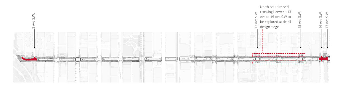
Raised intersections
Click to view larger image.
Click to view larger image. View north toward river pathway.
These are visionary illustrations subject to change.
Click to view larger image. View south toward 17 Ave S.W.
These are visionary illustrations subject to change.
Raised intersections are proposed at two locations along the corridor— from 3 Avenue S.W. to the riverfront and at the 16 Avenue S.W. intersection. These are intending to indicate the priority of people walking and wheeling to create safe, slow-speed crossings and public space at intersections connected to park spaces.
North-south raised crosswalks will be explored at the detail design stage between 13 Avenue S.W. and 15 Avenue S.W. In addition to prioritizing people walking and wheeling raised crossings can improve accessibility, reduce snow accumulation as well as calm traffic by indicating entrances or exits to residential areas.
The vision for the design of 8 Street S.W. was established in the Master Plan
The 8 Street S.W. Master Plan was completed in 2016.
It provides a vision that addresses area needs and enhances the pedestrian experience by focusing on improving areas such as sidewalks, street crossings and urban design.
The Master Plan lays the foundation for growing 8 Street SW as a livable, vibrant and thriving community corridor.
Frequently asked questions
General
What is the expected construction timeline?
Spring 2025 to Fall 2027
Where will construction occur?
Construction will begin on the north end of 8 Street SW near 2 Avenue SW and will continue south towards 10 Avenue SW over the course of the construction period.
The segment of 8 Street SW south of 10 Avenue SW to 17 Avenue SW is not currently funded for construction.
Interim safety improvements will be implemented to connect pathway users from 10 Avenue SW to the existing 12 Avenue SW cycle track.
Why is this work happening? Why now?
In 2021, The City of Calgary’s Council approved a new vision for the downtown through the Greater Downtown Plan, which highlights 8 Street SW as a key public space improvement project to advance the plan’s strategic goals.
In addition to adding new infrastructure in the corridor, the revitalization will also address aging assets in the area as part of The City’s regular infrastructure life cycling process. This will include:
- Improving the physical condition of the road (addressing tripping hazards, improving accessibility, reducing clutter, etc.), and
- Upgrades to damaged and deteriorating assets including transit waiting areas, traffic signals, streetlights, curbs and gutters, pavement markings and signage, drainage systems, street furniture and some utility infrastructure.
How is this project connected to Calgary’s Greater Downtown Plan?
8 Street S.W. is guided by the Greater Downtown Plan, approved by Council in 2021, which highlights it as a key capital project for improving vibrancy in Calgary’s downtown. The project supports several goals of the Greater Downtown Plan, including:
- Creating mixed-use communities with gathering places, housing choice, and all of the amenities nearby residents need;
- Building a green network by connecting parks, natural spaces, and river frontage with downtown’s main streets; and
- Designing streets for walkers and wheelers first, connecting the area to adjacent communities.
What’s the best way for those interested in the project to stay informed on construction updates?
For the latest information on upcoming detours and closures, please sign up for our e-newsletter or visit our website at calgary.ca/Revitalize8StreetSW
Water utility work
Why was additional water utility improvement work added to the project scope in early 2026?
The City is proactively addressing the water infrastructure in the area and will be performing system improvements to improve its reliability and resilience for our growing city. This will:
- Help us avoid the need for additional upgrades in the future by completing the work at the same time as the other improvements.
- Reduce the risk of future service disruptions and emergency repairs.
Will this added work extend the construction timeline for the 8 Street S.W. improvements?
Yes, because of the proactive utility improvements as part of this project, the completion timeline has been extended from early 2027 to late 2027. We appreciate your understanding and patience as we complete this important work.
Will my water be shut off while upgrades are being completed to water infrastructure in the area?
Those living and working along 8 Street S.W. between the 4-8 Avenue S.W. blocks may experience temporary water shut offs to complete water utility tie-ins and system improvements. We expect to complete this work between 4-6 Avenue S.W. in 2026 and 6-8 Avenue S.W. in 2027. These shut-offs will:
- Be short-term and localized
- Not affect all properties at the same time
- Be communicated in advance (at least 1 week, when possible) directly to property owners and businesses before any planned interruptions
- Be scheduled to minimize impacts wherever possible
Depending on the length of the water shut off, some properties may receive temporary water services for a portion or the entirety of the shut off at the discretion of The City.
Construction impacts
What pedestrian impacts can be expected during construction?
Pedestrians travelling through the corridor can expect sidewalk detours around active construction zones. Detour signage will be posted on site to help guide pedestrians safely through the area to their destinations.
How will vehicle traffic be impacted?
Lane closures will be required to facilitate construction along 8th Street SW. One lane in both directions will be maintained during construction to keep traffic moving through the corridor.
The design for 8 Street S.W. includes permanently reducing the laneways under the 9 Avenue S.W. bridge to a single lane in both directions. Once these changes are implemented in 2027, left turn movements at the 10 Avenue S.W. intersection will be discontinued to reduce congestion in this section of the corridor. Right turns will still be allowed at the intersection, but may be discontinued in the future depending on traffic patterns to keep Calgarians moving smoothly through the downtown core.
Will public transit be affected?
In order to replace the concrete in front of the west ramp of the 8 Street C-Train station, pedestrian access at the west end will be temporarily impacted and detours will be put in place to access the station from the east ramp.
Two bus stops will need to be temporarily relocated to facilitate construction along the corridor:
- The northbound stop on 8 Street SW at 7 Avenue, and
- The southbound stop on 8 Street SW at 7 Avenue.
Will parking and loading zones be affected?
Spring 2025 On-street parking is currently not permitted along 8 Street SW between 6 Avenue SW and 12 Avenue SW.
Calgarians can expect removal of 3 loading zones and 15 off-peak, on-street parking stalls between 4 Avenue SW and 6 Avenue SW.
Work occurring near Lot 6, a City-owned surface parking lot north of 4 Avenue SW, and the Bow River pathway will include removal an additional 15 all-day, on-street parking stalls and 12 surface parking stalls.
Several alternative parking options are available in the area along the connecting avenues and adjacent surface lots.
Businesses
How is The City supporting businesses that are affected by construction?
The City is helping businesses prepare for and manage the impacts of construction through:
- Early communication of potential disruptions via the website and email/e-newsletters.
- Enhanced wayfinding signage to support business needs.
- Relationship building with business owners to provide a direct line of support.
- Implementing programs and campaigns to encourage Calgarians to continue supporting local.
- Maintaining clear access to and from businesses throughout construction.
How can I prepare my business for construction?
We encourage business owners and operators to prepare for construction by:
- Visiting the project webpage often for the latest project information.
- Subscribing to our e-newsletter.
- Ensuring you have an up-to-date Business Continuity Plan (learn more and access free templates and tools by visiting calgary.ca/ReadyBusiness.
- Utilizing digital tools and other marketing techniques to keep your customers up-to-date of any business access changes, or other information like parking.
If I have a concern or question about construction happening near my business, who can I contact?
Please reach out to the project team with any questions or concerns at Revitalize8street@calgary.ca.