South Belvedere Area Structure Plan

Area Structure Plan South Belvedere
Over the next two years, The City of Calgary (The City) will work closely with landowners, area residents, and developers to create an Area Structure Plan (ASP) for the unplanned South Belvedere area. When we plan for new communities, we plan for clear, fair, and transparent development of new homes, businesses, and services.
Area map
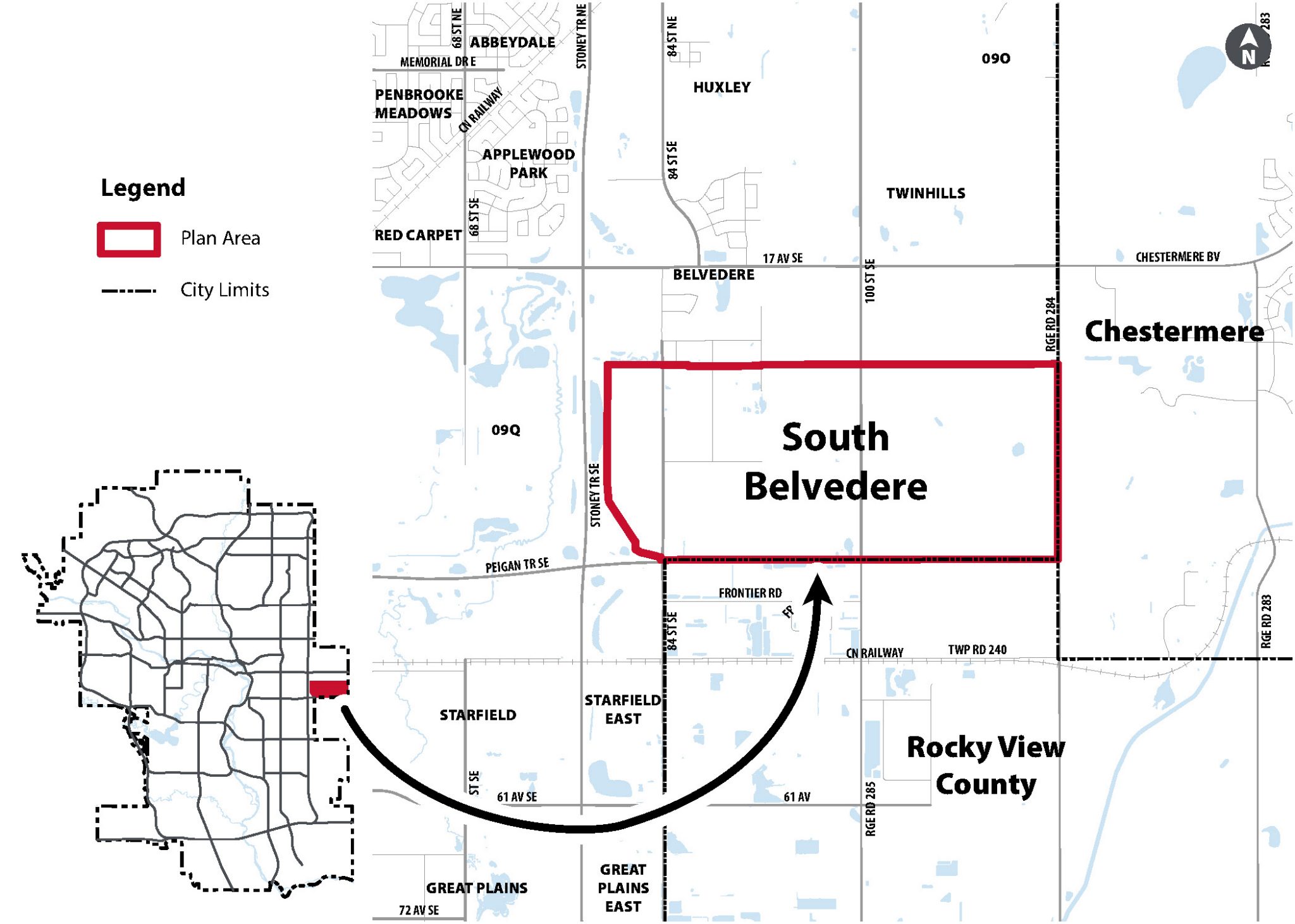
South Belvedere is east of Downtown Calgary and Stoney Trail. It is next to the Belvedere community on the north, Peigan Trail S.E. on the south, Range Road 284 on the east, and Stoney Trail S.E. on the west. Currently, the area has small and medium farms and rural homes.
The plan area is 588 hectares (1,453 acres) slightly larger than 2 farm sections. There are about 78 registered landowners. South Belvedere lands are next to The City of Chestermere and Rocky View County.
Background
South Belvedere lands are currently without an approved area structure plan. Lots of people are moving in, building homes and starting businesses in the Belvedere Area immediately to the North of these lands, showing a strong desire to live and work in the area.
A new plan will ensure that the development of more homes, businesses, and services in this area is predictable, fair, and efficient.
South Belvedere area is strategic because it’s close to downtown, easy to get to from Stoney Trail S.E., and near major existing employers and services. Additionally:
- The area is growing quickly.
- The area has scenic views of the downtown skyline and the Rocky Mountains.
- The area’s native streams and wetlands also give it a unique natural character.
Project priorities
The South Belvedere ASP will provide a clear plan for growth, support more housing choices, and coordinate major infrastructure projects like water servicing. It will also include strategies to reduce emissions and build inclusive communities.
Our goals are to:
Make a clear, practical plan that matches City Council’s priorities.
Work with landowners, regional partners, and the public.
Design complete communities that connect well with the region.
Protect nature and plan for climate challenges.
Want to get involved?
Your input is an important part of creating the Area Structure Plan (ASP) for South Belvedere area. Public engagement will happen in three phases:
After these phases of public engagement, the final draft ASP will be posted on our website for review before it goes to City Council for a decision.
Have your say
To learn how you can participate and share your ideas during public engagement for this project, visit our Engage page.
Stay connected
For updates subscribe to the South Belvedere ASP email list.
Project contact
- Jennifer Laforest, Senior Planner, Community Planning
- Mesbahul Alam, Senior Planner, Community Planning
- Bernadine Montero, Planner 1, Community Planning
Contact the team at:
SouthBelvedereASP@calgary.ca
Frequently asked questions
How will residents benefit from having this plan in place?
An Area Structure Plan (ASP) outlines how a community will grow and develop over time. It helps residents understand what changes to expect and provides opportunities for them to shape the future of their neighborhood. The plan also addresses essential services and amenities, such as parks, schools, fire stations, and public transit.
How will The City plan for traffic and congestion?
One of the most common questions we hear is how traffic congestion from new development will be managed. Planning for roads, pathways and transit involves many specialists. Once a land use concept is prepared Engineers, Planners and Landowners work together to prepare a Global Traffic Impact Assessment (TIA) which ensures transportation networks are designed to support the community as it grows. The results of the traffic planning and public feedback are reflected in the final draft of the area structure plan.
Will the ponds and wetlands in the area be protected?
As part of the planning project, independent ecologist and environmental policy planners prepare assessments of the lands. Their recommendations along with feedback from the public during project open houses and online, help shape the recommendations of the final plan.
What will be done to maintain the area’s unique character?
The City uses placemaking to keep and celebrate what makes each area special. The project team works with The City’s archaeologist, park planners, Indigenous Knowledge Keepers, local historians, and residents to identify and protect the unique features of the area.
How long will it take to create the new area structure plan?
This process usually takes about 24 months.
When will the plan area be fully built out?
It may take about 5–10 years before you start to see new subdivisions and larger commercial development to be built in the south belvedere area. There are many approvals required for these types of projects. Timing can also vary on things outside the City’s control, such as market demand, which can influence how quickly new communities are built out.
As an area resident, will I have to hook up to The City of Calgary water and sewer when those services come to my area?
You won’t have to connect to Calgary’s water and sewer services right away because they aren’t available yet in South Belvedere. As planning continues, The City will work with residents, landowners, and utility experts to look at different service options as utilities are gradually introduced in the area. The final plan will include recommendations on when and how connections might happen, balancing short-term needs with long-term benefits.
Will development in this area be affected by nearby landfills and industrial sites?
There are two landfills and industrial areas close to South Belvedere lands. The final Area Structure Plan will include policy guidance on land uses that are appropriate next to these areas.
Would there be a new name for this ASP?
For some Area Structure Plans (ASPs), the initial project name may differ from the final name adopted in the policy document. As an ASP progresses through the planning process and new information emerges, a shortlist of potential names is developed before selecting the final name. The history of the land, along with several other factors, plays an important role in this naming process. We follow The City of Calgary’s naming protocol when adopting new ASP names.
In recent years, landowners, residents, and The City have shown growing interest in incorporating original Indigenous place names wherever possible.