The City of Calgary Land Use Bylaw 1P2007
Top of page
PART 14: MIXED USE DISTRICTS
Division 3: Mixed Use - Active Frontage (MU-2f#h#d#) District
Purpose
2
The Mixed Use - Active Frontage District should only be located where a local area plan, or other policy, supports land use and development aligned with the purpose statements in subsections (1).
Permitted Uses
2
The following uses are permitted uses in the Mixed Use - Active Frontage District if they are located within existing approved buildings:
2.1
The following uses are permitted uses in the Mixed Use — Active Frontage District if they are located within existing approved buildings and if the public area is 150.0 square metres or less:
3
The following uses are permitted uses in the Mixed Use — Active Frontage if they are located within an existing approved building and are not located on the ground floor:
Discretionary Uses
1377
1
Uses listed in subsections 1376(2) and (3) are discretionary uses if they are located in proposed buildings or proposed additions to existing buildings in the Mixed Use - Active Frontage District.
1.1
The following uses are discretionary uses in the Mixed Use — Active Frontage District if they are located within existing approved buildings and if the public area is greater than 150.0 square metres.
1.2
The following uses are discretionary uses in the Mixed Use — Active Frontage District if they are located in proposed buildings or proposed additions to existing buildings:
2
Uses listed in subsection 1376(3) are discretionary uses in the Mixed Use - Active Frontage District if they are located on the ground floor of an existing approved building.
Floor Area Ratio
2
The maximum floor area ratio for parcels designated MU-2 is the number following the letter "f" indicated on the Land Use District Maps.
Building Height
1381
1
Unless otherwise referenced in subsections (2), (3) and (4), the maximum building height is the number following the letter "h" when indicated on the Land Use District Maps.
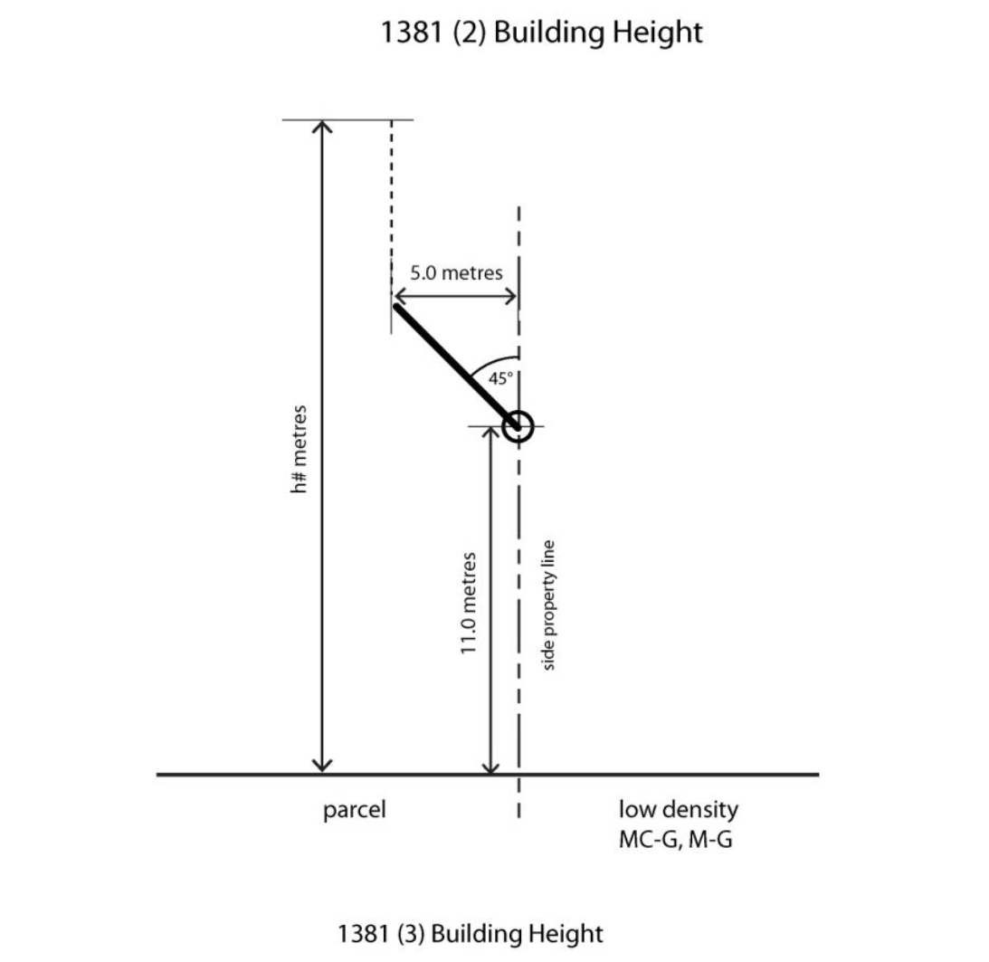
2
Where the parcel shares a side property line with a parcel designated as a low density residential district, H-GO, M-CG or M-G District the maximum building height:
b
increases at a 45 degree angle to a depth of 5.0 metres from the shared property line or to the number following the letter "h" indicated on the Land Use District Maps, whichever results in the lower building height; and
c
increases to the number following the letter "h" indicated on the Land Use District Maps measured from grade at a distance greater than 5.0 metres from the shared property line.
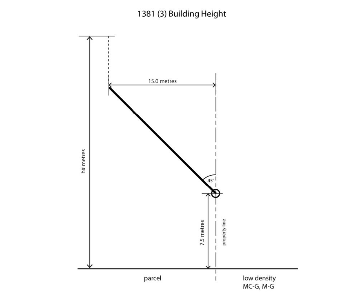
3
Where the parcel shares a rear property line with a parcel designated as a low density residential district, H-GO, M-CG or M-G District the maximum building height:
b
increases at a 45 degree angle to a depth of 15.0 metres from the shared property line or to the number following the letter "h" indicated on the Land Use District Maps measured from grade, whichever results in the lower building height; and
c
increases to the number following the letter "h" indicated on the Land Use District Maps measured from grade at a distance greater than 15.0 metres from the shared property line.
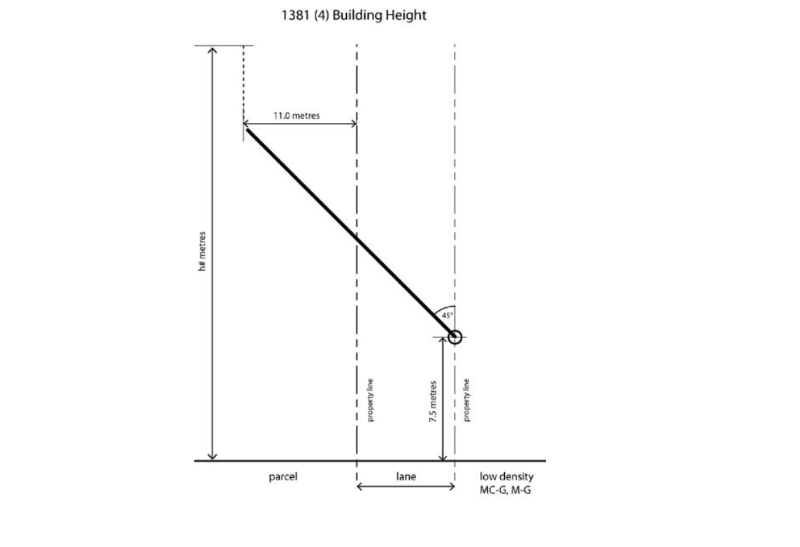
4
Where the parcel shares a property line with a lane that separates the parcel from a parcel designated as a low density residential district, H-GO, or M-CG District the maximum building height:
a
is 7.5 metres measured from grade at the property line that the parcel designated as a low density residential district, H-GO, M-CG or M-G District shares with the lane;
b
increases at a 45 degree angle to a depth of 11.0 metres from the property line shared with the lane or to the number following the letter "h" indicated on the Land Use District Maps, whichever results in the lower building height measured from grade; and
c
increases to the number following the letter "h" indicated on the Land Use District Maps measured from grade at a distance greater than 11.0 metres from the property line shared with the lane.
Use Area
1382
1
The maximum use area of a Catering Service — Minor, or a Catering Service — Minor combined with any other use, is 300.0 square metres.
2
The maximum public area for a Restaurant: Food Service Only or Restaurant: Licensed is 300.0 square metres.
Façade Width for Uses Facing a Street
1384
1
Unless otherwise referenced in subsections (2) and (3), the length of the building façade that faces a street containing an individual use on the floor closest to grade is a maximum of 15.0 metres.
2
For an individual Drinking Establishment — Medium, Drinking Establishment — Small, Restaurant: Food Service Only, Restaurant: Licensed, Retail and Consumer Service or Supermarket use located on the floor closest to grade, the length of the building façade that faces a street may be increased to 30.0 metres where all of the other uses that share the same façade meet the requirements of subsection (1).
3
The length of the building façade that faces a street containing an individual Health Care Service, Financial Institution, Office or Payday Loan use on the floor closest to grade is a maximum of 9.0 metres.
Setback Area
1385
1
Where a parcel shares a property line with a parcel designated as a low-density residential district, H-GO, M-CG or M-G:
b
with a lane that separates the parcel from a parcel designated as a residential district or mixed use district, the setback area must have a minimum depth of 7.5 metres measured from the property line that the adjacent parcel designated as a residential district or mixed use district shares with the lane; and
3
For the storey closest to grade, the maximum building setback from a property line shared with a street is 4.5 metres for 60 per cent of the length of the building façade that faces the street.
Illustration 11:
Building Height in the Mixed Use — Active Frontage (MU-2) District