Online Advertising for Planning Matters
Next Public Hearing
Date: July 21, 2026
Time: 9:30 a.m.
Location: Council Chambers, Calgary Municipal Building
Comment Submission deadline: 12:00 p.m., July 13, 2026
Meeting: Public Hearing of Council
-
Subscribe to get e-mail notifications of all planning-related news
-
Watch the Committee meeting live stream
-
Submit a written comment to the committee through the public submission form
-
Register to speak to the committee through the public submission form
Planning Matters advertised for the July 21, 2026 Public Hearing
NW
NE
SADDLE RIDGE INDUSTRIAL
LOC2025-0250
LAND USE REDESIGNATION
BYLAW 94D2026
To redesignate the land located at 3699 – 63 Avenue NE (Plan 0511592, Block 7, Lot 1) from Direct Control (DC) District to Direct Control (DC) District, to accommodate school and school-related uses.
LOC2025-0250
AMENDMENT TO THE SADDLE RIDGE AREA STRUCTURE PLAN
BYLAW 29P2026
The proposed amendments to the Saddle Ridge Area Structure Plan would allow for educational facilities in addition to fully serviced industrial uses. Amendments are being proposed to allow for the three-storey building located at 3699 - 63 Avenue NE to include school and school related uses with additional development guidelines. This proposed policy amendment is in conjunction with the proposed land use redesignation for the site (Bylaw 94D2026). For further information, please contact 403-850-5301.
TUXEDO PARK
LOC2025-0256
LAND USE REDESIGNATION
BYLAW 47D2026
To redesignate the land located at 302, 306 and 308 – 28 Avenue NE (Plan 2617AG, Block 38, Lots 23 to 26) from Residential – Grade-Oriented Infill (R-CG) District to Multi-Residential – Contextual Grade-Oriented (M-CG) District.
SW
BANKVIEW
LOC2026-0035
LAND USE REDESIGNATION
BYLAW 92D2026
To redesignate the land located at 2516 – 14A Street SW (Plan 3908R, Block 1, Lots 11 to 18) from Direct Control (DC) District to Direct Control (DC) District to accommodate a museum.
BELTLINE
LOC2025-0206
LAND USE REDESIGNATION
BYLAW 85D2026
To redesignate the land located at 1313 Centre Street SW (Plan C, Block 100, Lots 19 and 20) from Direct Control (DC) District to Direct Control (DC) District to accommodate mixed-used development through the conservation of a municipal historic resource.
LOC2025-0206
AMENDMENT TO THE BELTLINE AREA REDEVELOPMENT PLAN
BYLAW 23P2026
This policy amendment to the Beltline Area Redevelopment Plan: Part 1 is to allow for an increase in density on the subject parcel to be achieved through conservation of the George C. Cushing Residence, a Municipal Historic Resource. This proposed policy amendment is in conjunction with the proposed land use redesignation for the site (Bylaw 85D2026). For further information, please contact 587-576-4326.
CURRIE BARRACKS
LOC2026-0040
LAND USE REDESIGNATION
BYLAW 86D2026
To redesignate the land located at 270 Dieppe Drive SW (Plan 2311868, Block 12, Lot 2) from Direct Control (DC) District to Direct Control (DC) District to accommodate mixed use development.
ERLTON
LOC2025-0061
LAND USE REDESIGNATION
BYLAW 87D2026
To redesignate the land located at 108 Mission Road SW (Plan 5793U, Block 8, Lots 5 to 10) from Multi-Residential – Contextual Grade-Oriented (M-CGd72) District to Direct Control (DC) District to accommodate multi-residential development.
YORKVILLE
LOC2024-0252
LAND USE REDESIGNATION
BYLAW 93D2026
To redesignate the land located at 1414 – 210 Street SW (Portion of SW1/4 Section 16-22-1-5) from Residential – Low Density Multiple Dwelling (R-2M) District, Residential – Low Density Mixed Housing (R-G) District, Residential – Low Density Mixed Housing (R-Gm) District, Multi-Residential – At Grade Housing (M-G) District, Special Purpose – Urban Nature (S-UN) District, Special Purpose – School, Park and Community Reserve (S-SPR) District, and Special Purpose – City and Regional Infrastructure (S-CRI) District to Residential – Low Density Mixed Housing (R-G) District, Residential – Low Density Mixed Housing (R-Gm) District, Multi-Residential – At Grade Housing (M-G) District, Special Purpose – Urban Nature (S-UN) District, Special Purpose – School, Park and Community Reserve (S-SPR) District, and Special Purpose – City and Regional Infrastructure (S-CRI) District.
SE
ERIN WOODS
LOC2025-0193
LAND USE REDESIGNATION
BYLAW 91D2026
To redesignate the land located at 11 and 19 Erin Woods Drive SE (Plan 8010488, Block 3, Lots 17, 18 and 19) from Residential – Grade-Oriented Infill (R-CG) District and Multi-Residential – Contextual Grade-Oriented (M-CGd30) District to Mixed Use – General (MU-1f2.5h20) District.
LOC2025-0193
AMENDMENT TO THE EAST CALGARY INTERNATIONAL AVENUE COMMUNITIES LOCAL AREA PLAN
BYLAW 31P2026
The proposed policy amendment to the East Calgary International Avenue Communities Local Area Plan proposes to amend Section 2.3 Scale Modifiers, subsection 2.3.2, Low Scale-Modified to add a new policy to allow for site specific design guidelines for the property located at 11 and 19 Erin Woods Drive SE. The amendments are being proposed to allow for an additional storey. This proposed policy amendment is in conjunction with the proposed land use redesignation for the site (Bylaw 91D2026). For further information, please contact 403-968-2243.
GREAT PLAINS EAST
LOC2025-0068
LAND USE REDESIGNATION
BYLAW 88D2026
To redesignate the land located at 8025 – 84 Street SE (Plan 3565AG, portion of Block A) from Special Purpose – Future Urban Development (S-FUD) District to Special Purpose – Urban Nature (S-UN) District and Industrial – General (I-G) District.
MCKENZIE TOWNE
LOC2026-0003
LAND USE REDESIGNATION
BYLAW 83D2026
To redesignate the land located at 110 Elgin Terrace SE (Plan 0713338, Block 44, Lot 28) from Direct Control (DC) District to Residential – Low Density Mixed Housing (R-G) District.
OGDEN
LOC2025-0241
AMENDMENT TO THE MILLICAN-OGDEN AREA REDEVELOPMENT PLAN
BYLAW 21P2026
The proposed amendments to the Millican-Ogden Area Redevelopment Plan would change the land use policy for the site located at 8012 – 25 Street SE from Low Density Conservation to Low or Medium Density Multi-Dwelling Residential. This proposed policy amendment is required to enable the housing form and density permitted by the existing R-CG District for the site. For further information, please contact 368-889-9396.
LOC2026-0020
AMENDMENT TO THE MILLICAN-OGDEN AREA REDEVELOPMENT PLAN
BYLAW 22P2026
The proposed amendments to the Millican-Ogden Area Redevelopment Plan (ARP) would replace the Land Use Policy (Map 5) for the site located at 2416 – 76 Avenue SW from ‘Low Density Conservation’ to ‘Low or Medium Dwelling Multi-Unit Residential’ and establish a maximum density of 75 units per hectare. For more information, please contact 587-582-2129.
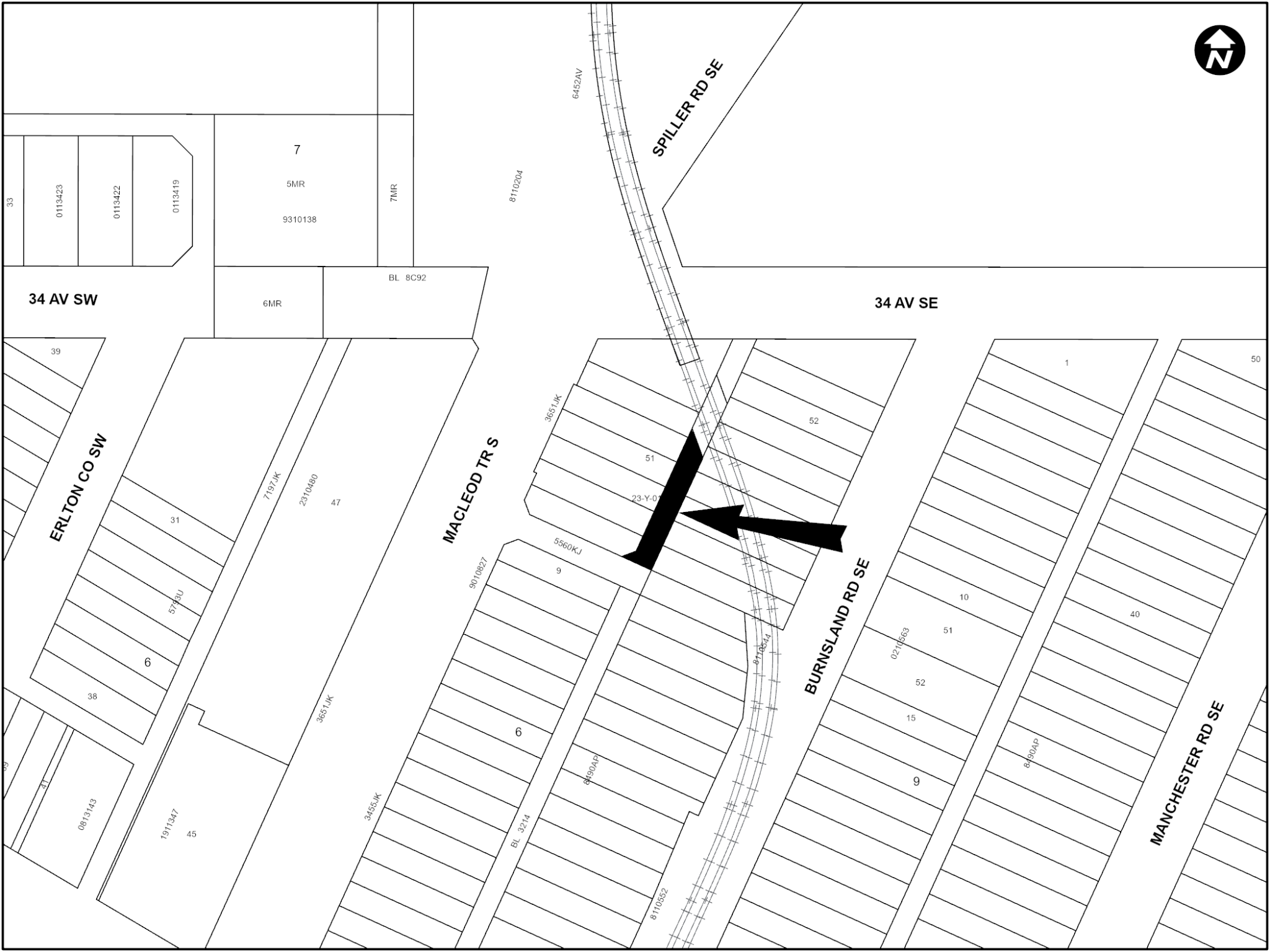
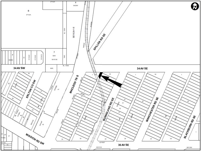
RAMSAY
LOC2026-0052
AMENDMENT TO THE RAMSAY AREA REDEVELOPMENT PLAN
BYLAW 30P2026
The proposed amendment to the Ramsay Area Redevelopment Plan would change the land use policy (Map 1) for the site located at 2125 Spiller Road SE from ‘Low Density Residential’ to ‘Low Density Multi Unit Residential’. For further information, please contact 587-582-2129.
RANGEVIEW
LOC2025-0175
LAND USE REDESIGNATION
BYLAW 90D2026
To redesignate the land located at 18800 – 52 Street SE (Portion of Plan 1812267, Block 1, Lot 1) from Residential – Low Density Mixed Housing (R-G) District, Residential – Low Density Mixed Housing (R-Gm) District, Multi-Residential – Medium Profile (M-2) District, Commercial – Neighbourhood 1 (C-N1) District and Commercial – Neighbourhood 2 (C-N2) District to Residential – Low Density Mixed Housing (R-G) District, Residential – Low Density Mixed Housing (R-Gm) District, Multi-Residential – Medium Profile (M-2) District and Commercial – Community 1 (C-C1) District.
RICARDO RANCH
LOC2025-0225
LAND USE REDESIGNATION
BYLAW 89D2026
To redesignate the land located at 245 and 415 Ricardo Ranch Road SE, 160 Church Road SE, 115 Nostalgia Drive SE, 21210 and 21209 – 72 Street SE (Plan 2610483, Block 8, Lots 1 and 2; Plan 2610483, Block 9, Lots 1 and 2; portion of Plan 1910908, Block 8, Lot 1; portion of Plan 2610514, Block 21, Lot 1) from Direct Control (DC) District to Direct Control (DC) District, to accommodate mixed use development with additional uses.
STARFIELD
LOC2025-0247
LAND USE REDESIGNATION
BYLAW 84D2026
To redesignate the land located at 5501 and 6201 – 68 Street SE (Portions of Plan 7558AF, Blocks M and N) from Special Purpose – School, Park and Community Reserve (S-SPR) District, Special Purpose – City and Regional Infrastructure (S-CRI) District, Special Purpose – Urban Nature (S-UN) District, Industrial – Business f1.0h20 (I-B f1.0h20) District, Industrial – Commercial (I-C) District and Industrial – General (I-G) District to Special Purpose – Urban Nature (S-UN) District, Special Purpose – City and Regional Infrastructure (S-CRI) District and Special Purpose – School, Park and Community Reserve (S-SPR) District.
Citywide
AMENDMENTS TO THE LAND USE BYLAW (1P2007)
C2026-0581
BYLAW 24P2026
This bylaw proposes amendments to Land Use Bylaw (LUB) 1P2007 to:
- Reduce the maximum density in the Residential – Grade-Oriented Infill (R-CG) District from 75 units per hectare to 60 units per hectare.
For further information please contact the Planning Service Centre 403-268-5311. The Bylaw amendment is proposed to come into effect on 2026 December 15.
AMENDMENTS TO THE LAND USE BYLAW (1P2007)
C2026-0581
BYLAW 25P2026
This bylaw proposes amendments to Land Use Bylaw (LUB) 1P2007 to:
- Prohibit main residential buildings in the rear yard on midblock Residential – Grade-Oriented Infill (R-CG) parcels.
For further information please contact the Planning Service Centre 403-268-5311. The Bylaw amendment is proposed to come into effect on 2026 December 15.
AMENDMENTS TO THE LAND USE BYLAW (1P2007)
C2026-0584
BYLAW 26P2026
This bylaw proposes amendments to Land Use Bylaw (LUB) 1P2007 to:
- List Secondary Suites as permitted uses in low density residential districts;
- List Backyard Suites as permitted uses in low density residential districts;
- Adjust rules so suites function effectively as permitted uses.
The proposed amendments would come into effect on 2026 August 05. For further information please contact the Planning Service Centre 403-268-5311.
AMENDMENTS TO THE LAND USE BYLAW (1P2007)
C2026-0416
BYLAW 27P2026
To redesignate parcels at various addresses listed in the table below from the:
- Residential – Contextual Large Parcel One Dwelling (R-C1L) (R-C1Ls) District, Residential – Contextual One Dwelling (R-C1) (R-C1s) District, Residential – Contextual Narrow Parcel One Dwelling (R-C1N) District, Residential – Contextual One / Two Dwelling (R-C2) District, and Residential – Grade Oriented Infill (R-CGex) to District to Residential – Grade Oriented Infill (R-CG) District;
- Residential One Dwelling (R-1) (R-1s) District, Residential – Narrow Parcel One Dwelling (R-1N) District, and Residential – One/Two Dwelling (R-2) District to Residential – Low Density Mixed Housing (R-G) District; and
- Residential – Contextual Large Parcel One Dwelling (R-C1L(s)) District, Residential – Contextual One Dwelling (R-C1) (R C1s), Residential – Contextual Narrow Parcel One Dwelling (R-C1N) District, Residential – Contextual One / Two Dwelling (R-C2) District, and Residential – Grade Oriented Infill (R-CGex) District to Housing – Grade Oriented (H-GO) District.
Bylaw 27P2026 would complete Council’s direction to bring a bylaw to reverse Rezoning for Housing back to the land use districts that existed before the citywide Rezoning for Housing in 2024 except for parcels that meet exemption criteria set out below:
- Received approval for a development permit that was not overturned by the Calgary Subdivision and Development Appeal Board between August 6, 2024, and August 4, 2026; or
- Received approval for a building permit or subdivision application under R-CG, R-G, or H-GO zoning before August 2, 2026; or
- Submitted a development permit, building permit, or subdivision application before April 8, 2026; or
- Were rezoned through an approved rezoning application submitted by the property owner after August 6, 2024.
The parcels listed in the table below meet one of the exemption criteria.
List and location maps for affected parcels.
AMENDMENTS TO THE LAND USE BYLAW (1P2007)
C2026-0461
BYLAW 28P2026
To redesignate parcels at various addresses listed in the table below from the:
- Residential – Grade Oriented Infill (R-CG) District to Residential – Contextual Large Parcel One Dwelling (R-C1L) (R-C1Ls) District, Residential – Contextual One Dwelling (R-C1) (R-C1s) District, Residential – Contextual Narrow Parcel One Dwelling (R-C1N) District, Residential – Contextual One / Two Dwelling (R-C2) District, and Residential – Grade Oriented Infill (R-CGex) District;
- Residential – Low Density Mixed Housing (R-G) District to Residential One Dwelling (R-1) (R-1s) District, Residential – Narrow Parcel One Dwelling (R-1N) District, and Residential – One/Two Dwelling (R-2) District; and
- Housing – Grade Oriented (H-GO) District to Residential – Contextual Large Parcel One Dwelling (R-C1L(s)) District, Residential – Contextual One Dwelling (R-C1) (R C1s), Residential – Contextual Narrow Parcel One Dwelling (R-C1N) District, Residential – Contextual One / Two Dwelling (R-C2) District, and Residential – Grade Oriented Infill (R-CGex) District.
Bylaw 28P2026 would complete Council’s direction to bring a bylaw to reverse Rezoning for Housing back to the land use districts that existed before the citywide Rezoning for Housing in 2024 except for parcels that meet exemption criteria set out below:
- Received approval for a development permit that was not overturned by the Calgary Subdivision and Development Appeal Board between August 6, 2024, and August 4, 2026; or
- Received approval for a building permit or subdivision application under R-CG, R-G, or H-GO zoning before August 2, 2026; or
- Submitted a development permit, building permit, or subdivision application before April 8, 2026; or
- Were rezoned through an approved rezoning application submitted by the property owner after August 6, 2024.
The parcels listed in the table below did not meet any of the exemption criteria.
Materials related to Planning Matters
Get involved – Submit a comment or register to speak
We encourage the public to be involved in planning matters. For the protection of the health, safety and well-being of the public and our employees, The City of Calgary is encouraging the public to participate in this public hearing of Council electronically or by phone.
Make a comment, or pre-register to address Council on any public hearing matter on this Agenda by submitting calgary.ca/publicsubmissions.
Only submissions received by the City Clerk by the deadline shall be included in the Agenda of Council.
Addressing Council: A person addressing Council has a maximum of five (5) minutes and shall limit their comments to the matter contained in the report and the recommendations being discussed.
For more details, please read our legal terms.
Archived planning matters
June, 23, 2026
NW
BANFF TRAIL
LOC2025-0245
LAND USE REDESIGNATION
BYLAW 78D2026
To redesignate the land located at 2227R Banff Trail NW and 2310 – 16 Avenue NW (Plan 9310554, Block 5, Lot 4; Plan 2511765, Block 5, Lot 6) from Direct Control (DC) District to Mixed Use – General (MU-1f3.0h26) District and Mixed Use – General (MU-1f9.1h100) District.
COUNTRY HILLS
LOC2024-0215
LAND USE REDESIGNATION
BYLAW 82D2026
To redesignate the land located at 9797 Harvest Hills Boulevard NW and 656 Country Hills Road NW (Portion of Plan 9712649, Block 1, Lot 41; Plan 9813226, Block 13, Lot 2) from Special Purpose – City and Regional Infrastructure (S-CRI) District to Mixed Use – General (MU-1f4.0h25) District.
LOC2024-0215
AMENDMENT TO THE CALGARY NORTH AREA STRUCTURE PLAN
BYLAW 20P2026
The proposed amendments to the Calgary North Area Structure Plan Phase 1 (ASP) are to address the lack of adequate policy guidance to allow for the development of multi-residential, mixed-use sites, and a transit terminal. The amendment introduces a new section titled “Special Policy Area 2”, providing clear policy direction for these uses. The amendment includes a new map identifying the Special Policy Area 2 (Map 9) and replaces the existing Land Use Plan map (Map 7) with an updated version that reflects the amendment area. The amendment to the ASP changes the land use classification for the subject parcels from ‘Residential’ to ‘Multi-Residential’. The policy amendments ensure that appropriate planning direction is in place to support the proposed development and facilitate its integration with surrounding development and transit infrastructure. This proposed policy amendment is in conjunction with the proposed land use redesignation for the site (Bylaw 82D2026). For further information, please contact 587-215-2052.
NE
CORNERSTONE
LOC2025-0003
LAND USE REDESIGNATION
BYLAW 80D2026
To redesignate the land located at 6660 Country Hills Boulevard NE (Portion of SE1/4 Section 26-25-29-4) from Special Purpose – Future Urban Development (S-FUD) District to Special Purpose – School, Park and Community Reserve (S-SPR) District and Direct Control (DC) District to accommodate additional uses.
CRESCENT HEIGHTS
LOC2025-0095
ROAD CLOSURE
BYLAW 3C2026
The City of Calgary intends pursuant to s.22 of the Municipal Government Act to consider bylaws to close from use and sell or hold those portions of the streets, roads, lanes or public highways described here.

LOC2025-0095
LAND USE REDESIGNATION
BYLAW 71D2026
To redesignate the closed road (Plan 2610342, Area ‘A’) from Undesignated Road Right-of-Way to Commercial – Corridor 2 f1.0h10 (C-COR2 f1.0h10) District.
KEYSTONE HILLS
LOC2024-0277
LAND USE REDESIGNATION
BYLAW 77D2026
To redesignate the land located at 14111 – 15 Street NE (Portion of NE1/4 Section 35-25-1-5) from Direct Control (DC) District to Mixed Use – General (MU-1f2.0h20) District.
LOC2024-0277
AMENDMENTS TO THE MUNICIPAL DEVELOPMENT PLAN
BYLAW 18P2026
The proposed amendments are to replace Volume 1, Map 1 entitled ‘Urban Structure’, Map 2 entitled ‘Primary Transit Network’, Map 3 entitled ‘Road and Street Network’ and Volume 3 (Calgary Transportation Plan), Map 2 entitled ‘Primary Transit Network’, Map 5 entitled ‘Primary HOV Goods Movement Network’, Map 6 entitled ‘Primary HOV Network’ and Map 7 entitled ‘Road and Street Network’ within the Municipal Development Plan. The amendments are being proposed to allow for residential development within the northeast community of Keystone Hills. For further information, please contact 368-995-2048.
LOC2024-0277
AMENDMENTS TO THE KEYSTONE HILLS AREA STRUCTURE PLAN
BYLAW 19P2026
Policy amendments to the Keystone Hills Area Structure Plan (ASP) are proposed in conjunction with the Land Use Amendment application for the neighbourhood of Keystone Hills.
The proposed amendments are to add a new land use area (Mixed Use) and replace Map 5 (Land Use Concept), Map 6 (Community & Neighbourhood Concept) and provide text amendments in Sections 6.2, 6.4.2, 6.4 and 6.11.1. The amendments are being proposed to allow for residential development within the northeast community of Keystone Hills. For further information, please contact 368-995-2048.
SKYVIEW RANCH
LOC2025-0228
LAND USE REDESIGNATION
BYLAW 81D2026
To redesignate the land located at 120 Skyview Ranch Drive NE (Condominium Plan 1811695, Unit 2) from Multi-Residential – Low Profile (M-1) District to Direct Control (DC) District to accommodate the additional use of Health Care Service.
SUNRIDGE
LOC2026-0006
LAND USE REDESIGNATION
BYLAW 79D2026
To redesignate the land located at 2121 – 29 Street NE (Plan 9912522, Block 6, Lot 2) from Direct Control (DC) District to Direct Control (DC) District, to accommodate a Gaming Establishment – Bingo.
SW
EVERGREEN
LOC2026-0018
LAND USE REDESIGNATION
BYLAW 68D2026
To redesignate the land located at 2525 Eversyde Avenue SW (Portion of Plan 0412677, Block 1, Lot 52) from Direct Control (DC) District to Multi-Residential – At Grade Housing (M-G) District.
GLENDALE
LOC2025-0187
LAND USE REDESIGNATION
BYLAW 69D2026
To redesignate the land located at 4524 Grove Hill Road SW (Plan 626GV, Block 25, Lot 6) from Housing – Grade Oriented (H-GO) District to Residential – Grade-Oriented Infill (R-CG) District.
KILLARNEY/GLENGARRY
LOC2026-0016
LAND USE REDESIGNATION
BYLAW 65D2026
To redesignate the land located at 3627 Kildare Crescent SW (Plan 732GN, Block 4, Lot 35) from Direct Control (DC) District to Residential – Grade-Oriented Infill (R-CG) District.
LOC2026-0009
LAND USE REDESIGNATION
BYLAW 66D2026
To redesignate the land located at 2823 – 30 Street SW (Plan 732GN, Block 9, Lot 54 and portion of Lot 53) from Direct Control (DC) District to Residential – Grade-Oriented Infill (R-CG) District.
MISSION
LOC2025-0209
LAND USE REDESIGNATION
BYLAW 73D2026
To redesignate the land located at 111 and 115 – 17 Avenue SW (Plan 0514387, Block 3, Lot 33; Plan 9511724, Block 3, Lot 2) from Commercial – Corridor 2 f3.0h46 (C-COR2 f3.0h46) District to Mixed Use – General (MU-1f8.0h58) District and Mixed Use – Active Frontage (MU2f5.0h24) District.
SOUTH CALGARY
LOC2025-0224
LAND USE REDESIGNATION
BYLAW 75D2026
To redesignate the land located at 1516 – 29 Avenue SW (Plan 4479P, Block 27, Lots 7 and 8) from Multi-Residential – Contextual Low Profile (M-C1d75) District to Commercial – Corridor 1 f1.0h12 (C-COR1f1.0h12) District.
SUNALTA
LOC2026-0015
LAND USE REDESIGNATION
BYLAW 74D2026
To redesignate the land located at 1732 – 11 Avenue SW (Plan 5380V, Block 216, Lot 36) from Direct Control (DC) District to Multi-Residential – High Density Low Rise (M-H1) District.
UPPER MOUNT ROYAL
LOC2025-0151
LAND USE REDESIGNATION
BYLAW 67D2026
To redesignate the land located at 1911 – 11 Street SW (Plan 179R, Block 43, Lot 7) from Direct Control (DC) District to Direct Control (DC) District to establish a maximum parcel width and minimum building setback.
SE
INGLEWOOD
LOC2026-0007
LAND USE REDESIGNATION
BYLAW 70D2026
To redesignate the land located at 1323 – 10 Avenue SE (Plan A3, Block 5, Lot 24) from Residential – Grade-Oriented Infill (R-CG) District to Housing – Grade Oriented (H-GO) District.
LOC2025-0186
LAND USE REDESIGNATION
BYLAW 72D2026
To redesignate the land located at 1336 and 1340 – 9 Avenue SE (Plan A3, Block 7, Lots 17 to 19 and Lot A) from Direct Control (DC) District to Direct Control (DC) District to accommodate retention of a heritage building and mixed use redevelopment around it.
LEGACY
LOC2025-0153
LAND USE REDESIGNATION
BYLAW 76D2026
To redesignate the land located at 22200 – 28 Street SE (portion of NW1/4 Section 8-22-29-4 and portion of SW1/4 Section 8-22-29-4) from Multi-Residential – Low Profile (M-1) District, Residential – Low Density Mixed Housing (R-G) District, Residential – Low Density Multiple Dwelling (R-2M) District and Special Purpose – Urban Nature (S-UN) District to Direct Control (DC) District to accommodate multi-residential development.
OGDEN
LOC2025-0216
AMENDMENT TO THE MILLICAN-OGDEN AREA REDEVELOPMENT PLAN
BYLAW 17P2026
The proposed amendments to the Millican-Ogden Area Redevelopment Plan would amend Map 5 entitled ‘Proposed Land Use Policies’ for the site located at 2108 – 66 Avenue SE from Low Density Conservation to Low or Medium Density Multi-Dwelling Residential. This proposed policy amendment is required to enable the housing form and density permitted by the existing R-CG District for the site. For further information, please contact 368-889-7381.
May 12, 2026
NW
BANFF TRAIL
LOC2025-0171
LAND USE REDESIGNATION
BYLAW 63D2026
To redesignate the land located at 2471 – 23 Street NW (Plan 9110GI, Block 4, Lot 21) from Multi-Residential – High Density Low Rise (M-H1 d280f3.6h20) District to Direct Control (DC) District to accommodate site specific development rules.
HASKAYNE
LOC2025-0070
LAND USE REDESIGNATION
BYLAW 54D2026
To redesignate the land located at 6600 and 6815 – 133 Street NW (Portion of Plan 5126JK, Block D; Portion of Plan 1911645, Block 1, Lot 1) from Commercial – Community 1 (C-C1) District to Multi-Residential – Low Profile (M-1) District and Special Purpose – Community Service (S-CS) District.
HILLHURST
LOC2025-0133
LAND USE REDESIGNATION
BYLAW 46D2026
To redesignate the land located at 1202, 1204, 1206, 1210, 1212, 1214, 1218 and 1220 – 5 Avenue NW (Plan 5609J, Block S, Lots 1 to 10) from Direct Control (DC) District to Multi-Residential – High Density High Rise (M-H3f6.0h40) District.
LOC2025-0248
LAND USE REDESIGNATION
BYLAW 49D2026
To redesignate the land located at 1601 Bowness Road NW (Plan 5151O, Block 19, Lots 57 and 58) from Mixed Use – General (MU-1f1.0h13) District to Residential – Grade-Oriented Infill (R-CG) District.
LOC2025-0195
LAND USE REDESIGNATION
BYLAW 53D2026
To redesignate the land located at 207 and 211 – 14 Street NW (Plan 6219L, Block 3, Lots 4 to 11, and a portion of Lot 12) from Commercial – Corridor 2 f2.8h16 (C-COR2 f2.8h16) District and Direct Control (DC) District to Mixed Use – Active Frontage (MU-2f4.0h24) District.
NE
CITYSCAPE
LOC2025-0113
LAND USE REDESIGNATION
BYLAW 52D2026
To redesignate the land located at 10011 – 52 Street NE (Portion of SE1/4 Section 22-25-29-4) from Residential – Low Density Mixed Housing (R-G) District to Direct Control (DC) District, to accommodate low-density residential development.
STONEGATE LANDING
LOC2024-0171
LAND USE REDESIGNATION
BYLAW 64D2026
To redesignate the land located at 12331, 12414, 13030, 13440, 13440R, 13601, 13621 – 36 Street NE, 1300, 1450, 1495, 1500, 1570 Barlow Crescent NE, 3699, 4440 Country Hills Boulevard NE, 12939 Métis Trail NE and 4200 – 128 Avenue NE (Portion of NE 1/4 Section 28-25-29-4; Portion of NW 1/4 Section 27-25-29-4; Portion of W 1/2 Section 34-25-29-4; Portion of SE 1/4 Section 33-25-29-4; Plan 9212612 Lot B; Plan 1310593 Block 5 Lot 5; Plan 1611320 Block 5 Lot 6; Plan 0913802 Block 4 Lot 2; Plan 0913802 Block 5 Lot 2; Plan 1811898 Block 5 Lot 8; Plan 0614349 Block A; Portion SW 1/4 Section 27-25-29-4; Plan 1711309 Block 5 Lot 7; Plan 1811898 Block 5 Lot 9) from Industrial – General (I-G) District, Industrial – Business (I-Bf0.5h27) District, Commercial – Regional 3 (C-R3f0.23h18) District, Commercial – Regional 3 (C-R3f0.3h18) District, Commercial – Regional 3 (C-R3f0.5h18) District, Special Purpose – City and Regional Infrastructure (S-CRI) District to Industrial General (I-G) District, Industrial – Commercial (I-C) District, Commercial – Regional 3 (C-R3f0.5h18) District, Commercial – Community 2 (C-C2f2.0h24) District, Commercial – Neighbourhood 1 (C-N1) District, Residential – Low Density Mixed Housing (R-G) (R-Gm) District, Multi-Residential – At Grade Housing (M-G) District, Multi-Residential – Low Profile (M-1) District, Multi-Residential – High Density Low Rise (M-H1) District, Mixed Use – General (MU-1f3.5h24) District, Special Purpose – City and Regional Infrastructure (S-CRI) District, and Special Purpose – School, Park and Community Reserve (S-SPR) District.
LOC2024-0171
AMENDMENTS TO THE MUNICIPAL DEVELOPMENT PLAN
BYLAW 15P2026
The proposed amendments are to replace Volume 1, Map 1 entitled ‘Urban Structure’ and Volume 3 (Calgary Transportation Plan), Map 5 entitled ‘Primary Goods Movement Network’ within the Municipal Development Plan. The amendments are being proposed to allow for commercial development within the northeast community of Stonegate Landing. For further information, please contact 587-576-3104.
LOC2024-0171
AMENDMENTS TO THE NORTHEAST INDUSTRIAL AREA STRUCTURE PLAN
BYLAW 16P2026
The proposed amendments are to add a new land use areas (Mixed Use, Multi-Unit Residential, Ground-Oriented Residential) within Sections 2 to 18 and replace Map 1 (Plan Area), Map 2 (Planning Cells), Map 3 (Land Use Concept), Map 4 (Wetland Study Area) and add Map 6 (Planning Cell A and C Phasing) within the Northeast Industrial Area Structure Plan. The amendments are being proposed to allow for residential development within the northeast community of Stonegate Landing. For further information, please contact 587-576-3104.
TUXEDO PARK
LOC2025-0256
LAND USE REDESIGNATION
BYLAW 47D2026
To redesignate the land located at 302, 306 and 308 – 28 Avenue NE (Plan 2617AG, Block 38, Lots 23 to 26) from Residential – Grade-Oriented Infill (R-CG) District to Multi-Residential – Contextual Grade-Oriented (M-CG) District.
WESTWINDS
LOC2025-0210
LAND USE REDESIGNATION
BYLAW 51D2026
To redesignate the land located at 3633 Westwinds Drive NE (Plan 0412252, Block 6, Lot 4) from Commercial – Regional 1 f0.2 (C-R1 f0.2) District to Commercial – Regional 3 f0.25h18 (C-R3 f0.25h18) District.
SW
BELTLINE
LOC2025-0242
LAND USE REDESIGNATION
BYLAW 56D2026
To redesignate the land located at 310 – 15 Avenue SW (Condominium Plan 2511573, Units 1 to 307) from Direct Control (DC) District and Centre City Multi-Residential High Rise District (CC-MH) to Centre City Multi-Residential High Rise Support Commercial District (CC-MHX).
LOC2025-0254
LAND USE REDESIGNATION
BYLAW 57D2026
To redesignate the land located at 1302 – 14 Avenue SW and 721 – 13 Avenue SW (Plan 2311640, Block 97, Lot 55; Plan A1, Block 91, Lots 10, 11, a portion of Lot 9 and a portion of Lot 12) from Centre City Multi-Residential High Rise District (CC-MH) and Direct Control (DC) District to Direct Control (DC) District to accommodate heritage density transfer.
DOWNTOWN COMMERCIAL CORE
LOC2025-0137
LAND USE REDESIGNATION
BYLAW 58D2026
To redesignate the land located at 728 – 4 Avenue SW (Plan A1, Block 13, Lots 32 to 38 and a portion of Lot 31) from Direct Control (DC) District to Direct Control (DC) District to accommodate a mixed-use high-rise development.
LOC2025-0137
AMENDMENT TO THE EAU CLAIRE AREA REDEVELOPMENT PLAN
BYLAW 14P2026
The proposed amendment to the Eau Claire Area Redevelopment Plan (ARP) is intended to accommodate the development of a mixed-use building with density bonusing provisions. This proposed policy amendment is in conjunction with the proposed land use redesignation for the site (Bylaw 58D2026). For further information, please contact 403-268-1940.
KILLARNEY/GLENGARRY
LOC2025-0179
LAND USE REDESIGNATION
BYLAW 50D2026
To redesignate the land located at 3036 and 3040 – 29 Street SW (Plan 5661O, Block 53, Lots 41 to 44) from Direct Control (DC) District to Housing – Grade Oriented (H-GO) District.
LOC2025-0234
LAND USE REDESIGNATION
BYLAW 61D2026
To redesignate the land located at 2208, 2212, 2216, 2220 and 2224 – 37 Street SW (Plan 2412BC, Block 12E, Lots 23 to 26; Plan 9212018, Block 12E, Lot 27A; Plan 1725AJ, Block 12E, Lots 29 to 32) from Multi-Residential – Contextual Low Profile (M-C1) District to Mixed Use – General (MU-1f4.0h24) District.
MANCHESTER
LOC2025-0066
LAND USE REDESIGNATION
BYLAW 55D2026
To redesignate the land located at 5325 – 1A Street SW (Plan 5454AC, Block 12, Lots 32 and 33) from Industrial Redevelopment (I-R) District to Commercial – Corridor 2 f3.5h18 (C-COR 2 f3.5h18) District.
SE
BURNS INDUSTRIAL
LOC2025-0119
LAND USE REDESIGNATION
BYLAW 59D2026
To redesignate the land located at 6010 – 12 Street SE (Plan 1213072, Block 9, Lot 11) from Industrial – Commercial (I-C) District to Direct Control (DC) District to accommodate Place of Worship – Small and Place of Worship – Medium.
MAHOGANY
LOC2025-0180
LAND USE REDESIGNATION
BYLAW 62D2026
To redesignate the land located at 1236, 1251 and 1325 Mahogany Boulevard SE (Plan 2510331, Block 144, Lot 5; Plan 2510331, Block 148, Lots 1 and 3) from Multi-Residential – Low Profile (M-1d75) District and Direct Control (DC) District to Mixed Use – General (MU-1f3.5h26) District.
MAPLE RIDGE
LOC2025-0214
LAND USE REDESIGNATION
BYLAW 60D2026
To redesignate the land located at 10411 – 15 Street SE (Plan 1711612, Block 2, Lot 1) from Special Purpose – Urban Nature (S-UN) District to Direct Control (DC) District to accommodate an additional use of Storage Yard.
MIDNAPORE
LOC2025-0226
LAND USE REDESIGNATION
BYLAW 48D2026
To redesignate the land located at 15307 – 1 Street SE (Plan 4571GP, Block 2, Lot 14) from Special Purpose – Future Urban Development (S-FUD) District to Multi-Residential – Contextual Low Profile (M-C1) District.
OGDEN
LOC2025-0236
AMENDMENT TO THE MILLICAN-OGDEN AREA REDEVELOPMENT PLAN
BYLAW 13P2026
The proposed amendment to the Millican-Ogden Area Redevelopment Plan would change the land use policy located at 8002 – 24 Street SE from ‘Low Density Conservation’ to ‘Low or Medium Density Multi-Dwelling Residential’ and aligns the policy with the existing site’s Residential – Grade-Oriented Infill (R-CG) District.
April 21, 2026
NW
BANFF TRAIL
LOC2025-0150
LAND USE REDESIGNATION
BYLAW 36D2026
To redesignate the land located at 2435 – 23 Street NW (Plan 9110GI, Block 4, Lot 30) from Residential – Grade-Oriented Infill (R-CG) District to Direct Control (DC) District to establish a minimum density.
PARKDALE
LOC2025-0183
LAND USE REDESIGNATION
BYLAW 37D2026
To redesignate the land located at 811 – 28 Street NW (Plan 331AB, Block 26, Lots 1 and 2) from Residential – Grade-Oriented Infill (R-CG) District to Direct Control (DC) District to accommodate a minimum density.
TUXEDO PARK
LOC2025-0184
LAND USE REDESIGNATION
BYLAW 44D2026
To redesignate the land located at 3013 and 3019 Centre Street NW (Plan 3980AM, Block 46, Lots 6 to 10) from Residential – Grade-Oriented Infill (R-CG) District to Mixed Use – Active Frontage (MU-2f6.5h42d708) District.
NE
CRESCENT HEIGHTS
LOC2025-0219
LAND USE REDESIGNATION
BYLAW 41D2026
To redesignate the land located at 301, 303 and 307 – 15 Avenue NE (Plan 791P, Block 33, Lots 11 to 14) from Multi-Residential – Contextual Grade-Oriented (M-CGd72) District to Multi-Residential – Contextual Grade-Oriented (M-CG) District.
DEERFOOT BUSINESS CENTER
LOC2025-0124
LAND USE REDESIGNATIO
BYLAW 40D2026
To redesignate the land located at 1020 – 68 Avenue NE (Plan 7911331, Block 5, Lots 1 to 6 and 14 to 17) from Industrial – General (I-G) District to Direct Control (DC) District to accommodate the uses of School – Private and School Authority – School.
TUXEDO PARK
LOC2025-0217
LAND USE REDESIGNATION
BYLAW 43D2026
To redesignate the land located at 1914 and 1918 Centre Street NE (Plan 2129O, Block 12, Lots 4, 5 and a portion of 6) from Direct Control (DC) District to Mixed Use – Active Frontage (MU-2f4.3h24) District.
WESTWINDS
LOC2024-0241
LAND USE REDESIGNATION
BYLAW 42D2026
To redesignate the land located at 3660 Westwinds Drive NE (Plan 0410759, Block 5, Lot 1) from Direct Control (DC) District to Commercial – Community 1 (C-C1) District.
SE
COPPERFIELD
LOC2025-0009
LAND USE REDESIGNATION
BYLAW 39D2026
To redesignate the land located at 1210 Copperfield Boulevard SE (Plan 1811719, Block 42, Lot 1) from Commercial – Neighbourhood 2 (C-N2) District to Mixed Use – Active Frontage (MU-2f1.2h13) District.
FAIRVIEW INDUSTRIAL
LOC2025-0215
LAND USE REDESIGNATION
BYLAW 45D2026
To redesignate the land located at 7048 and 7052 Farrell Road SE (Plan 6524JK, Block 38B, Lots 3 and 4) from Industrial – General (I-G) District to Industrial – Commercial (I-C) District.
OGDEN
LOC2025-0207
AMENDMENTS TO THE MILLICAN-OGDEN AREA REDEVELOPMENT PLAN
BYLAW 11P2026
The proposed amendments to the Millican-Ogden Area Redevelopment Plan would change the land use policy located at 7443 – 20A Street SE from ‘Low Density Conservation’ to ‘Low or Medium Density Multi-Dwelling Residential’ and add 7443 – 20A Street SE to the list of addresses under Section 3.4.3 Residential Land Use, subsection 3.4.3.3 Policies, Policy 2 (a) to align the policy with the site’s Residential – Grade-Oriented Infill (R-CG) District.
LOC2025-0237
AMENDMENTS TO THE MILLICAN-OGDEN AREA REDEVELOPMENT PLAN
BYLAW 12P2026
The proposed amendments to the Millican-Ogden Area Redevelopment Plan would change the land use policy located at 7604 – 21A Street SE from ‘Low Density Conservation’ to ‘Low or Medium Density Multi-Dwelling Residential’ and add 7604 – 21A Street SE to the list of addresses under Section 3.4.3 Residential Land Use, subsection 3.4.3.3 Policies, Policy 2 (a) to align the policy with the site’s Residential – Grade-Oriented Infill (R-CG) District. For further information, please contact 587-223-3019.
SECTION 23
LOC2025-0057
LAND USE REDESIGNATION
BYLAW 38D2026
To redesignate the land located at 6020 – 94 Avenue SE (Plan 2511257, Block 1, Lot 23) from Direct Control (DC) District to Direct Control (DC) District to accommodate an additional use of Materials Recycling Facility.
LOC2025-0057
AMENDMENT TO THE SOUTHEAST INDUSTRIAL AREA STRUCTURE PLAN
BYLAW 10P2026
The proposed amendment to the Southeast Industrial Area Structure Plan would change Map 2 entitled ‘Land Use and Transportation Plan’ for the site located at 6020 – 94 Avenue SE from ‘Existing I-4 Limited Serviced Industrial District’ to ‘Existing I-3 Heavy Industrial District’. This proposed policy amendment is in conjunction with the proposed land use redesignation for the sites (Bylaw 38D2026). For further information, please contact 403-200-8575.
March 23, 2026
CITYWIDE
AMENDMENTS TO THE LAND USE BYLAW 1P2007
BYLAW 9P2026
This bylaw proposes amendments to Land Use Bylaw (LUB) 1P2007 to:
- Insert previously deleted low density residential districts, delete Land Use Bylaw amendments approved under Bylaw 21P2024 and replace the amended sections with rules as they existed prior to citywide rezoning;
- Change the zoning of residential properties back to what existed before the citywide Rezoning for Housing in 2024, except for properties that:
- Received approval for a development permit, building permit or subdivision application under R-CG, R-G, or H-GO zoning before the proposed bylaw takes effect; or
- Submitted a development permit, building permit or subdivision application before the first reading of the proposed bylaw; or
- Rezoned through an approved rezoning application applied for by the property owner after August 6, 2024.
- Textual amendments for non-conforming buildings and uses;
- Amendments to the Residential – Grade Oriented Infill (R-CG) District to reduce parcel coverage, building height and density, introduce contextual setback requirements, eliminate zero lot line provisions, limit parcels to one primary building and prohibit rowhouse and townhouse forms on mid-block parcels; and
- Textual amendments to retain other Council directed Land Use Bylaw amendments that were approved following the adoption of Bylaw 21P2024.
For further information please contact the Planning Service Centre 403-268-5311 or visit Repeal of Citywide Rezoning for Housing (Calgary.ca). The restoration of the previously deleted low density residential districts is proposed to come into effect on 2026 August 02. Parcel redesignations are proposed to take effect on 2026 August 03, and the textual amendments addressing non‑conforming situations, changes to the R‑CG district, and the retention of other Council directed amendments are proposed to take effect on 2026 August 04.
March 21, 2026
NW
BOWNESS
LOC2025-0107
LAND USE REDESIGNATION
BYLAW 23D2026
To redesignate the land located at 6516 – 35 Avenue NW (Plan 4610AJ, Block 26, a portion of Lot 3) from Residential – Grade-Oriented Infill (R-CG) District to Multi-Residential – Contextual Grade-Oriented (M-CG) District.
NE
HORIZON
LOC2025-0148
LAND USE REDESIGNATION
BYLAW 28D2026
To redesignate the land located at 3359 – 27 Street NE (Condominium Plan 8111015, Units 1 to 10) from Industrial – General (I-G) District to Industrial – Commercial (I-C) District.
SW
KILLARNEY/GLENGARRY
LOC2025-0211
LAND USE REDESIGNATION
BYLAW 27D2026
To redesignate the land located at 2803 – 32 Street SW (Plan 732GN, Block 9, Lot 25) from Direct Control (DC) District to Housing – Grade Oriented (H-GO) District.
PINE CREEK
LOC2024-0012
LAND USE REDESIGNATION
BYLAW 34D2026
To redesignate the land located at 21900 Sheriff King Street SW (Plan 0212654, Block 1, Lot 1) from Special Purpose – Future Urban Development (S-FUD) District to Multi-Residential – Low Profile (M-1) District, Residential – Low Density Mixed Housing (R-G) District, Special Purpose – School, Park and Community Reserve (S-SPR) District and Special Purpose – Urban Nature (S-UN) District.
ROSSCARROCK
LOC2025-0165
LAND USE REDESIGNATION
BYLAW 30D2026
To redesignate the land located at 1626, 1628, 1630 and 1632 – 38 Street SW and 3820 – 17 Avenue SW (Plan 1427HB, Block 32, Lots 5 to 9) from Mixed Use – Active Frontage (MU-2f3.0h46) District, Direct Control (DC) District and Multi-Residential – Contextual Medium Profile (M-C2) District to Mixed Use – General (MU-1f7.0h46) District and Mixed Use – General (MU-1f4.0h24) District.
WILDWOOD
LOC2025-0185
LAND USE REDESIGNATION
BYLAW 31D2026
To redesignate the land located at 157 Wedgewood Drive SW (Plan 975HC, Block 22, Lot 58) from Housing – Grade Oriented (H-GO) District to Direct Control (DC) District to accommodate commercial uses.
SE
BELVEDERE
LOC2025-0045
LAND USE REDESIGNATION
BYLAW 33D2026
To redesignate the land located at 1825 – 92 Street SE and 9025 and 9115 – 17 Avenue SE (Plan 1858AD, Blocks 3 to 5) from Special Purpose – Future Urban Development (S-FUD) District to Commercial – Community 1 (C-C1) District, Commercial – Regional 3 f1.0h11 (C-R3 f1.0h11) District, Special Purpose – Urban Nature (S-UN) District, Special Purpose – City and Regional Infrastructure (S-CRI) District and Mixed Use – General (MU-1f4.5h40) District.
LOC2025-0045
AMENDMENT TO THE BELVEDERE AREA STRUCTURE PLAN
BYLAW 8P2026
The proposed amendments to the Belvedere Area Structure Plan would change the land use policy for the site located at 1825 – 92 Street SE and 9025 and 9115 – 17 Avenue SE from Special Study Area to Community Retail 2 Centre. This proposed policy amendment is in conjunction with the proposed land use redesignation for the site (Bylaw 33D2026). For further information, please contact 587-223-2498.
DOUGLASDALE/GLEN
LOC2025-0182
LAND USE REDESIGNATION
BYLAW 32D2026
To redesignate the land located at #400 – 163 Quarry Park Boulevard SE (Plan 1010880, Block 3, Lot 6) from Direct Control (DC) District to Commercial – Community 2 f0.5h16 (C-C2f0.5h16) District.
FRANKLIN
LOC2025-0126
LAND USE REDESIGNATION
BYLAW 29D2026
To redesignate the land located at 128 and 188 – 28 Street SE and 2908 – 2 Avenue SE (Plan 9410382, Block 4, Lot 8; Plan 7711662, Block 4, Lots 4 and 5) from Industrial – General (I-G) District to Commercial – Corridor 3 f1.0h12 (C-COR3 f1.0h12) District.
February 17, 2026
NW
BOWNESS
LOC2025-0107
LAND USE REDESIGNATION
BYLAW 23D2026
To redesignate the land located at 6516 – 35 Avenue NW (Plan 4610AJ, Block 26, a portion of Lot 3) from Residential – Grade-Oriented Infill (R-CG) District to Multi-Residential – Contextual Grade-Oriented (M-CG) District.
COUNTRY HILLS
LOC2024-0215
LAND USE REDESIGNATION
BYLAW 24D2026
To redesignate the land located at 9797 Harvest Hills Boulevard NW and 656 Country Hills Road NW (Portion of Plan 9712649, Block 1, Lot 41; Plan 9813226, Block 13, Lot 2) from Special Purpose – City and Regional Infrastructure (S-CRI) District to Mixed Use – General (MU-1f4.0h25) District.
LOC2024-0215
AMENDMENTS TO THE CALGARY NORTH AREA STRUCTURE PLAN PHASE 1
BYLAW 7P2026
The proposed amendments to the Calgary North Area Structure Plan Phase 1 (ASP) are to address the lack of adequate policy guidance to allow for the development of multi-residential, mixed-use sites, and a transit terminal. The amendment introduces a new section titled “Special Policy Area 2”, providing clear policy direction for these uses. The amendment includes a new map identifying the Special Policy Area 2 (Map 9) and replaces the existing Land Use Plan map (Map 7) with an updated version that reflects the amendment area. The amendment to the ASP changes the land use classification for the subject parcels from ‘Residential’ to ‘Multi-Residential’. The policy amendments ensure that appropriate planning direction is in place to support the proposed development and facilitate its integration with surrounding development and transit infrastructure. This proposed policy amendment is in conjunction with the proposed land use redesignation for the site (Bylaw 24D2026). For further information, please contact 587-215-2052.
MORAINE
LOC2025-0078
LAND USE REDESIGNATION
BYLAW 25D2026
To redesignate the land located at 15353 and 15655 – 14 Street NW and 1600 – 144 Avenue NW (NE1/4 Section 5-26-1-5; Portion of SE1/4 Section 5-26-1-5) from Special Purpose – Future Urban Development (S-FUD) District to Residential – Low Density Mixed Housing (R-G) District, Residential – Low Density Mixed Housing (R-Gm) District, Multi-Residential – Low Profile (M-1) District, Multi-Residential – Low Profile Support Commercial (M-X1) District, Special Purpose – City and Regional Infrastructure (S-CRI) District and Special Purpose – School, Park and Community Reserve (S-SPR) District.
NE
TUXEDO PARK
LOC2025-0140
LAND USE REDESIGNATION
BYLAW 16D2026
To redesignate the land located at 253 – 19 Avenue NE (Plan 1367O, Block 1, Lots 37 and 38) from Residential – Grade-Oriented Infill (R-CG) District to Housing – Grade Oriented (H-GO) District.
SW
ALTADORE
LOC2025-0167
LAND USE REDESIGNATION
BYLAW 12D2026
To redesignate the land located at 1537 and 1539 – 34 Avenue SW (Plan 2259N, Block B, Lots 1 to 3) from Multi-Residential – Contextual Low Profile (M-C1) District to Mixed Use – General (MU-1f4.0h24) District.
ASPEN WOODS
LOC2025-0046
LAND USE REDESIGNATION
BYLAW 21D2025
To redesignate the land located at 1330 and 1380 – 85 Street SW (Plan 4415R, a portion of Block 4) from Direct Control (DC) District to Residential – Low Density Mixed Housing (R-G) District and Special Purpose – School, Park and Community Reserve (S-SPR) District.
BANKVIEW
LOC2025-0166
LAND USE REDESIGNATION
BYLAW 15D2026
To redesignate the land located at 2213 and 2215 – 14 Street SW (Plan 261L, Block 13, Lots 14 and 15) from Multi-Residential – Contextual Medium Profile (M-C2) District to Mixed Use – General (MU-1f3.5h23) District.
BELTLINE
LOC2025-0041
LAND USE REDESIGNATION
BYLAW 19D2026
To redesignate the land located at 906 – 12 Avenue SW (Plan A1, Block 74, Lots 21 to 34) from Centre City Mixed Use District (CC-X) to Direct Control (DC) District to accommodate an addition to an existing building.
LOC2025-0041
AMENDMENTS TO THE BELTLINE AREA REDEVELOPMENT PLAN
BYLAW 6P2026
The proposed amendments to the Beltline Area Redevelopment Plan: Part 1 would change the land use policy for the site located at 906 – 12 Avenue SW. The amendments include changes to Policies 4.4.6 and 4.4.7 as well as Tables 4.2 and 4.3 relating to floorplate and tower separation to allow for this site to be developed with a 12-storey addition on the existing 9-storey building with relaxations. This proposed policy amendments are in conjunction with the proposed land use redesignation for the site (Bylaw 19D2026). For further information, please contact 587-224-3062.
SHAGANAPPI
LOC2025-0154
LAND USE REDESIGNATION
BYLAW 22D2026
To redesignate the land located at 3310 – 14 Avenue SW (Plan 2512165, Block 4, Lot 20) from Multi-Residential – Contextual Medium Profile (M-C2) District to Mixed Use – General (MU-1f4.0h28) District.
SPRINGBANK HILL
LOC2025-0011
LAND USE REDESIGNATION
BYLAW 26D2026
To redesignate the land located at 30 Elveden Drive SW (Plan 2370IB, Block 2, Lot 5) from Residential – Low Density Mixed Housing (R-G) District to Direct Control (DC) District to accommodate development that transitions in height and number of units across the site.
LOC2025-0011
AMENDMENT TO THE SPRINGBANK HILL AREA STRUCTURE PLAN
BYLAW 76P2025
The proposed amendment to the Springbank Hill Area Structure Plan would change the land use policy for the site located at 30 Elveden Drive SW from Standard Suburban to Low Density. This proposed policy amendment is in conjunction with the proposed land use redesignation for the site (Bylaw 26D2026). For further information, please contact 403-268-5344.
SE
EAST VILLAGE
LOC2025-0067
LAND USE REDESIGNATION
BYLAW 18D2026
To redesignate the land located at 501, 505, 509, 511, 515, 517, 519, 521, and 527 – 8 Avenue SE (Plan A; Block 58; Lots 1 to 14) from Centre City East Village Integrated Residential District (CC-EIR) and Centre City East Village Primarily Residential District (CC-EPR) to Direct Control (DC) District to accommodate mixed-use development.
LOC2025-0067
AMENDMENT TO THE EAST VILLAGE AREA REDEVELOPMENT PLAN
BYLAW 5P2026
This policy amendment is to add a new policy to the East Village Area Redevelopment Plan for the parcels located at the southeast corner of 8 Avenue SE and 4 Street SE (501, 505, 509, 511, 515, 517, 519, 521, 527 8 Avenue SE) to allow for a maximum density of 10.0 floor area ratio (FAR). The change is being proposed to allow for this site to be developed with mixed-use high-rise towers. This proposed policy amendment is in conjunction with the proposed land use redesignation for the site (Bylaw 18D2026). For further information, please contact 403-268-1940
FOREST LAWN
LOC2025-0160
LAND USE REDESIGNATION
BYLAW 17D2026
To redesignate the land located at 2001 and 2007 – 37 Street SE (Plan 2335AH, Block 13, Lots 17 to 20) from Residential – Grade-Oriented Infill (R-CG) District to Housing – Grade Oriented (H-GO) District.
MAHOGANY
LOC2025-0156
LAND USE REDESIGNATION
BYLAW 20D2026
To redesignate the land located at 2120 Mahogany Boulevard SE (Portion of Plan 0113267, Block 1, Lot 5) from Multi-Residential – Medium Profile (M-2) District to Residential – Low Density Multiple Dwelling (R-2M) District.
MANCHESTER INDUSTRIAL
LOC2023-0167
ROAD CLOSURE
BYLAW 1C2026
The City of Calgary intends pursuant to s.22 of the Municipal Government Act to consider bylaws to close from use and sell or hold those portions of the streets, roads, lanes or public highways described here.
LOC2023-0167
LAND USE REDESIGNATION
BYLAW 13D2026
To redesignate the land located at 311 – 34 Avenue SE, 3610 Macleod Trail SE and the closed road (Plan 8490AP, Block 6, Lots 2 to 6 and portions of Lots 1, 7 and 41 to 45; Plan 2411344, Area ‘A’) from Industrial – Redevelopment (I-R) District, Commercial – Corridor 3 f3.0h46 (C-COR3 f3.0h46) District and Undesignated Road Right-of-Way to Multi-Residential – High Density Medium Rise (M-H2f3.0h30) District.
LOC2023-0166
ROAD CLOSURE
BYLAW 2C2026
The City of Calgary intends pursuant to s.22 of the Municipal Government Act to consider bylaws to close from use and sell or hold those portions of the streets, roads, lanes or public highways described here.
OGDEN
LOC2025-0173
AMENDMENT TO THE MILLICAN-OGDEN AREA REDEVELOPMENT PLAN
BYLAW 3P2026
The proposed amendments to the Millican-Ogden Area Redevelopment Plan would change the land use policy for the site located at 7428 – 24 Street SE from ‘Low Density Conservation’ to ‘Low or Medium Density Multi-Dwelling Residential’ and clarify that 75 units per hectare is appropriate on the subject site. For further information, please contact 368-889-2774.
LOC2025-0174
AMENDMENT TO THE MILLICAN-OGDEN AREA REDEVELOPMENT PLAN
BYLAW 4P2026
The proposed amendments to the Millican-Ogden Area Redevelopment Plan would change the land use policy for the site located at 7235 – 25 Street SE from ‘Low Density Conservation’ to ‘Low or Medium Density Multi-Dwelling Residential’ and clarify that 75 units per hectare is appropriate on the subject site. For further information, please contact 368-889-2774.
CITYWIDE
PROPOSED BYLAW 1H2026 TO ESTABLISH A PROCESS FOR GIVING NOTICE OF A PROPOSED LAND USE BYLAW AMENDMENT BY ELECTRONIC MEANS WHERE THE PROPOSED AMENDMENT WOULD AFFECT MORE THAN 500 PARCELS OF LAND
A Public Hearing will be held at the Council Chamber, Calgary Municipal Building, 800 Macleod Trail SE, Tuesday, 2026 February 17, commencing at 9:30 a.m. If the Public Hearing is still in progress at 9:30 p.m., Council will conclude the matter under discussion and reconvene at 1:00 p.m. on the next business day, unless otherwise directed by Council.
The purpose of the public hearing will be to consider a proposed bylaw to establish a process for giving notice of a proposed land use bylaw amendment by electronic means where the proposed amendment would affect more than 500 parcels of land.
A copy of the proposed bylaw and related documents may be reviewed by the public:
- during office hours, 8:00 a.m. to 4:30 p.m., Monday to Friday, at the Office of the City Clerk, Corporate Records Section, main street level of the Administration Building, 313 – 7 Avenue SE; or
- on The City of Calgary website at Calgary.ca/council/meetings/documents-for-public-viewing.
Persons wishing to provide a written submission concerning a proposed bylaw may do so provided they are printed, typewritten or legibly written and include the name of the writer, bylaw number in the subject line, mailing address or email address if submitting electronically, and must focus on the merits of the proposed bylaw. Submissions will only be used for City Council’s consideration of the issue before them. Only submissions received no later than 12:00 p.m. 2026 February 9, will be included in the Agenda of Council. Public submissions will be reviewed in accordance with Section 46 of Procedure Bylaw 42M2025 prior to being included in the Agenda.
Submissions may be directed to one of the following:
- delivered or mailed to: Office of the City Clerk, The City of Calgary, 700 Macleod Trail SE, P.O. Box 2100, Postal Station “M”, Calgary Alberta T2P 2M5; or
- submitted online at Calgary.ca/publicsubmissions.
Persons wishing to address Council at the 2026 February 17 Public Hearing Meeting of Council on any matter stated on this notice may register using the Public Submissions Form at Calgary.ca/publicsubmissions. Speakers may address Council either in-person or remotely for a period of FIVE (5) MINUTES (exclusive of any time required to answer questions). Comments must be limited to the proposed bylaw that is before Council.
Speakers may, with the consent of the Chair, supplement their presentations by providing written presentation materials to be included in the Corporate Record for the meeting.
Written submission materials can also be provided through the Public Submissions Form at Calgary.ca/publicsubmissions, or e-mailed to publicsubmissions@calgary.ca, and must be received no later than 12:00 p.m. (noon) eight days before the meeting. Video submissions and large files must be uploaded in accordance with instructions available at Calgary.ca/publichearings.
Pursuant to Section 231 of the Municipal Government Act (the “MGA”), an elector may submit a petition for a vote of the electors to determine whether a proposed bylaw should be passed. The process for submitting such a petition is set out in Sections 221 to 226 of the MGA.
Personal information provided in submissions is collected under the authority of the Procedure Bylaw 42M2025, section 216.4 of the MGA, and Sections 4(a) and (c) of the Protection of Privacy Act of Alberta.
If you have any questions on the use of this information or require further information on the Public Hearing Meeting, you may contact the City Clerk’s Office at 403-268-5861 or publicsubmissions@calgary.ca. For questions regarding proposed Bylaw 1H2026, call 311.
January 20, 2026
MONTGOMERY
LOC2025-0161
LAND USE REDESIGNATION
BYLAW 3D2026
To redesignate the land located at 4816 Bowness Road NW (Plan 5439FW, Block 22, Lot 4) from Residential – Grade-Oriented Infill (R-CG) District to Housing – Grade Oriented (H-GO) District.
WEST HILLHURST
LOC2025-0132
LAND USE REDESIGNATION
BYLAW 7D2026
To redesignate the land located at 2330 and 2332 – 5 Avenue NW (Plan 5612FO, Block 12, Lot 55 and 56) from Residential – Grade-Oriented Infill (R-CG) District to Housing – Grade Oriented (H-GO) District.
SADDLE RIDGE
LOC2024-0282
LAND USE REDESIGNATION
BYLAW 6D2026
To redesignate the land located at 5111 – 88 Avenue NE, 5112 and 5124 – 85 Avenue NE (Plan 6778AW, Block 7; Plan 1211515, Block 35, Lots 3 and 4) from Special Purpose – Future Urban Development (S-FUD) District and Multi-Residential – Low Profile (M-1) District to Multi-Residential – Medium Profile (M-2) District and Special Purpose – School, Park and Community Reserve (S-SPR) District.
ALTADORE
LOC2025-0090
LAND USE REDESIGNATION
BYLAW 8D2026
To redesignate the land located at 2039 and 2043 – 34 Avenue SW (Plan 4530AC, Block 3, Lots 19 to 22 and a portion of Lot 23) from Multi-Residential – Contextual Low Profile (M-C1) District and Mixed Use – General (MU-1f3.0h16) District to Mixed Use – General (MU-1f4.0h24) District.
BELTLINE
LOC2025-0080
LAND USE RDESIGNATION
BYLAW 5D2026
To redesignate the land located at 532 and 534 – 17 Avenue SW (Plan A1, Block 107, Lots 38 to 43 and a portion of Lot 37) from Commercial – Corridor 1 f3.0h23 (C-COR1f3.0h23) District to Commercial – Corridor 1 f4.0h24 (C-COR1f4.0h24) District.
LOC2025-0080
AMENDMENT TO THE BELTLINE AREA REDEVELOPMENT PLAN
BYLAW 1P2026
This proposal is to amend the Beltline Area Redevelopment Plan: Part 1 in order to accommodate increased density on 532 – 17 Avenue SW and 534 – 17 Avenue SW. The amendment will add text to Table 5: Density Areas to allow these sites to reach a maximum of floor area ratio (FAR) 4.0. This amendment is associated with the proposed land use change for this site – Bylaw 5D2026. For further information, please contact 587-576-1845.
GLENDALE
LOC2025-0139
LAND USE REDESIGNATION
BYLAW 1D2026
To redesignate the land located at 4939 – 17 Avenue SW (Plan 6182HM, Block 5, Lot 42) from Residential – Grade-Oriented Infill (R-CG) District to Housing – Grade Oriented (H-GO) District.
KILLARNEY/GLENGARRY
LOC2025-0138
LAND USE REDESIGNATION
BYLAW 2D2026
To redesignate the land located at 2034 – 28 Street SW (Plan 5661O, Block 10, Lots 23 and 24) from Direct Control (DC) District to Residential – Grade-Oriented Infill (R-CG) District.
RICHMOND
LOC2025-0109
LAND USE REDESIGNATION
BYLAW 162D2025
To redesignate the land located at 2309 Richmond Road SW (Plan 8997GC, Block 6, Lot 15) from Residential – Grade-Oriented Infill (R-CG) District to Direct Control (DC) District to establish a minimum residential density.
SILVERADO
LOC2024-0227
LAND UE REDESIGNATION
BYLAW 11D2026
To redesignate the land located at 8 Silverton Way SW (Plan 9712011, Block 6, Lot 1) from Special Purpose – Future Urban Development (S-FUD) District to Commercial – Community 1 (C-C1) District, Multi-Residential – Low Profile (M-1d78) District, Mixed Use – General (MU-1f3.5h24) District, Special Purpose – School, Park and Community Reserve (S-SPR) District and Direct Control (DC) District to accommodate a self storage facility.
APPLEWOOD PARK
LOC2024-0299
LAND USE REDESIGNATION
BYLAW 10D2026
To redesignate the land located at 7220 – 17 Avenue SE (Plan 45LK, Block C, Lot 2) from Multi-Residential – High Density Low Rise (M-H1f1.8h20) District to Multi-Residential – High Density Low Rise (M-H1f2.5h22) District.
EAST SHEPARD INDUSTRIAL
LOC2025-0162
LAND USE REDESIGNATION
BYLAW 4D2026
To redesignate the land located at 10906 – 50 Street SE (Plan 1510434, Block 17, Lot 3) from Industrial – General (I-G) District to Industrial – Commercial (I-C) District.
RAMSAY
LOC2025-0177
AMENDMENT TO THE RAMSAY AREA REDEVELOPMENT PLAN
BYLAW 2P2026
The proposed amendment to the Ramsay Area Redevelopment Plan would change the land use policy located at 1106 – 9 Street SE from ‘Low Density Residential’ to ‘Low Density Multi Unit Residential’ and aligns the policy with the existing site’s Residential – Grade-Oriented Infill (R-CG) District.
RICARDO RANCH
LOC2025-0142
LAND USE REDESIGNATION
BYLAW 9D2026
To redesignate the land located at 21410 – 40 Street SE (Portion of Plan 2210445, Block 1, Lot 2) from Residential – Low Density Mixed Housing (R-Gm) District to Direct Control (DC) District to accommodate low density residential development with reduced parcel sizes.
December 16
NW
BANFF TRAIL
LOC2025-0158
LAND USE REDESIGNATION
BYLAW 180D2025
To redesignate the land located at 2419 – 21 Street NW (Plan 9110GI, Block 12, Lot 15) from Residential – Grade-Oriented Infill (R-CG) District to Direct Control (DC) District to establish a minimum residential density.
GREENWOOD/GREENBRIAR
LOC2025-0099
LAND USE REDESIGNATION
BYLAW 178D2025
To redesignate the land located at 9723 and 9819 – 46 Avenue NW, 9723 – 47 Avenue NW and 9600 Bowfort Road NW (Plan 8167GK, Lots 16 and 17; Plan 8167GK, Lots 9 and 10; Plan 2110547, Block A) from Special Purpose – School, Park and Community Reserve (S-SPR) District and Direct Control (DC) District to Special Purpose – Recreation (S-R) District and Special Purpose – School, Park and Community Reserve (S-SPR) District.
NE
CRESCENT HEIGHTS
LOC2024-0221
LAND USE REDESIGNATION
BYLAW 181D2025
To redesignate the land located at 414, 416, 420, 424, 428, 435A and 441 – 1 Avenue NE, 434, 436, 438, 440, 442 and 448 Marsh Road NE and the closed road, (Plan 1332N, Block 4, Lots 11 to 20; Plan 1332N, portion Block B; Plan 5855I, Lot 26 and Lot 29; Plan 1814HW, Lots 1 and 2; Plan 7810635, Lot 1; Plan 9210946, Lot 26A; Plan 9310135, Lot 1; Plan 2511304, Area ‘A’) from Multi-Residential – Contextual Medium Profile (M-C2) District and Undesignated Road Right-of-Way to Mixed Use – General (MU-1f6.0h45) District and Mixed Use – General (MU-1f4.0h24) District.
LOC2024-0221
ROAD CLOSURE
BYLAW 12C2025
The City of Calgary intends pursuant to s.22 of the Municipal Government Act to consider bylaws to close from use and sell or hold those portions of the streets, roads, lanes or public highways described here.
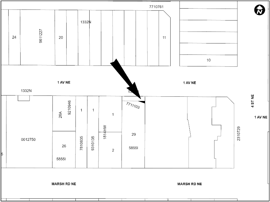
PLAN 2511304, AREA ‘A’
LOC2024-0221
AMENDMENT TO THE BRIDGELAND-RIVERSIDE AREA REDEVELOPMENT PLAN
BYLAW 85P2025
The proposed amendment to the Bridgeland-Riverside Area Redevelopment Plan would change the land use policy for the site located at 414, 416, 420, 424, 428, 435A and 441 – 1 Avenue NE, 434, 436, 438, 440, 442 and 448 Marsh Road NE and the closed road from Non Family Oriented Development to Community – Centre, supported by policy within the Developed Areas Guidebook. This proposed policy amendment is in conjunction with the proposed land use redesignation for the site (Bylaw 181D2025) and proposed road closure (Bylaw 12C2025). For further information, please contact 587-576-3104.
LEWISBURG
LOC2025-0096
LAND USE REDESIGNATION
BYLAW 177D2025
To redesignate the land located at 14120 – 9 Street NE (Plan 2510849, Block 16, Lot 2) from Multi-Residential – Low Profile (M-1) District to Mixed Use – General (MU-1f3.5h25) District.
MAYLAND
LOC2024-0254
LAND USE REDESIGNATION
BYLAW 179D2025
To redesignate the land located at 1729 – 8 Avenue NE (Plan 1014791, Block 1, Lot 1) from Industrial – Business f1.0h12 (I-B f1.0h12) District to Multi-Residential – High Density Low Rise (M-H1) District.
SW
BELTLINE
LOC2025-0079
LAND USE REDESIGNATION
BYLAW 176D2025
To redesignate the land located at 1112, 1116, 1120 and 1124 – 17 Avenue SW (Plan A1, Block 118, Lots 10 to 14) from Commercial – Corridor 1 f3.0h23 (C-COR1f3.0h23) and Direct Control (DC) District to Commercial – Corridor 1 f4.0h24 (C-COR1f4.0h24) District.
LOC2025-0079
AMENDMENT TO THE BELTLINE AREA REDEVELOPMENT PLAN
BYLAW 84P2025
This proposal is to amend the Beltline Area Redevelopment Plan: Part 1 in order to accommodate increased density on 1112, 1116, 1120 and 1124 - 17 Avenue SW. The amendment will add text to Table 5: Density Areas to allow these sites to reach a maximum of 4.0 FAR. This amendment is associated with the proposed land use change for this site (Bylaw 176D2025). For further information, please contact 587-576-1845.
KILLARNEY/GLENGARRY
LOC2025-0157
LAND USE REDESIGNATION
BYLAW 173D2025
To redesignate the land located at 3204 – 30 Street SW (Plan 5435AV, Block 3C, Lots 11 and 12) from Direct Control (DC) District to Residential – Grade-Oriented Infill (R-CG) District.
LOC2025-0149
LAND USE REDESIGNATION
BYLAW 174D2025
To redesignate the land located at 2803 – 30 Street SW (Plan 732GN, Block 9, Lot 49) from Direct Control (DC) District to Residential – Grade-Oriented Infill (R-CG) District.
NORTH GLENMORE PARK
LOC2025-0018
LAND USE REDESIGNATION
BYLAW 168D2025
To redesignate the land located at 2135, 2139 and 2143 – 50 Avenue SW (Plan 8620AH, Block 17, Lots 1 to 6) from Residential – Grade-Oriented Infill (R-CG) District to Mixed Use – General (MU-1f4.0h24) District.
SOUTH CALGARY
LOC2025-0116
LAND USE REDESIGNATION
BYLAW 169D2025
To redesignate the land located at 1516 and 1520 – 28 Avenue SW (Plan 4479P, Block 10, Lots 7 to 10 and a portion of Lot 11) from Multi-Residential – Contextual Low Profile (M-C1) District to Housing – Grade Oriented (H-GO) District.
SUNALTA
LOC2025-0024
LAND USE REDESIGNATION
BYLAW 171D2025
To redesignate the land located at 1528 – 16 Avenue SW (Plan 5380V, Block 202, Lot 33) from Multi-Residential – Contextual Medium Profile (M-C2) District to Direct Control (DC) District to accommodate Health Care Services.
SE
BELTLINE
LOC2025-0089
LAND USE REDESIGNATION
BYLAW 170D2025
To redesignate the land located at 1109 and 1117 Macleod Trail SE and 229 and 233 – 11 Avenue SE (Plan C; Block 80; Lots 15 to 28) from Direct Control (DC) District to Direct Control (DC) District to accommodate a mixed-use development.
BELVEDERE
LOC2024-0098
LAND USE REDESIGNATION
BYLAW 172D2025
To redesignate the land located at 9305 and 9555 – 17 Avenue SE, and the closed road (Portion of NE 1/4 Section 7-24-28-4; Plan 7510208, Block 1; Plan 2511162, Area ‘A’) from Special Purpose – Future Urban Development (S-FUD) District and Undesignated Road Right-of-Way to Residential – Low Density Mixed Housing (R-G) District, Residential – Low Density Mixed Housing (R-Gm) District, Multi-Residential – At Grade Housing (M-G) District, Multi-Residential – High Density Low Rise (M-H1) District, Mixed Use – General (MU-1f4.0h26) District, Mixed Use – General (MU-1f5.5h40) District, Mixed Use – Active Frontage (MU-2f4.0h26) District, Special Purpose – City and Regional Infrastructure (S-CRI) District, Special Purpose – School, Park and Community Reserve (S-SPR) District and Special Purpose – Urban Nature (S-UN) District.
LOC2024-0098
ROAD CLOSURE
BYLAW 11C2025
The City of Calgary intends pursuant to s.22 of the Municipal Government Act to consider bylaws to close from use and sell or hold those portions of the streets, roads, lanes or public highways described here.
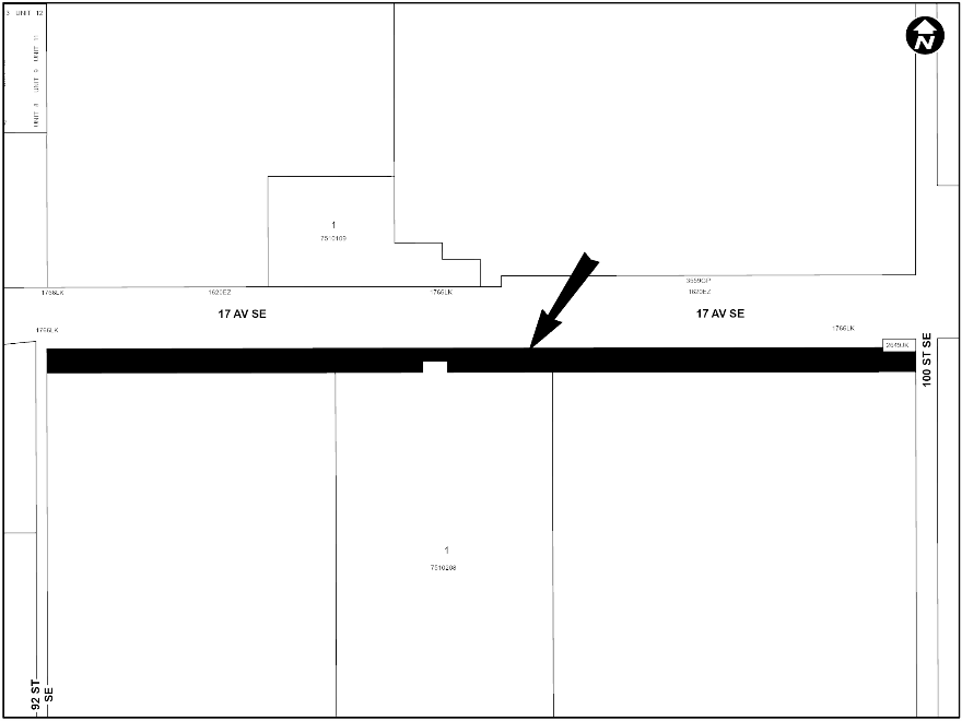
PLAN 2511162, AREA ‘A’
INGLEWOOD
LOC2024-0198
LAND USE REDESIGNATION
BYLAW 175D2025
To redesignate the land located at 1631 and 1639 – 17A Street SE (Plan 4939O, Block WW, Lots 1 to 6) from Residential – Grade-Oriented Infill (R-CG) District and Commercial – Corridor 2 f2.0h8 (CCOR2 f2.0h8) District to Commercial – Corridor 1 f3.0h20 (C-COR1f3.0h20) District.
LEGACY
LOC2025-0131
LAND USE REDESIGNATION
BYLAW 167D2025
To redesignate the land located at 1689 Legacy Circle SE (Plan 1411876, Block 22, Lot 24) from Direct Control (DC) District to Residential – Low Density Mixed Housing (R-G) District.
OGDEN
LOC2025-0128
AMENDMENT TO THE MILLICAN-OGDEN AREA REDEVELOPMENT PLAN
BYLAW 82P2025
The proposed amendments to the Millican-Ogden Area Redevelopment Plan (ARP) would change the land use classification for the subject parcel located at 7211 – 21 Street SE from ‘Low Density Conservation’ to ‘Low or Medium Density Multi Dwelling’. The amendments are intended to accommodate a four dwelling unit townhouse development with four secondary suites. For further information, please contact 587-572-0642.
LOC2025-0152
AMENDMENT TO THE MILLICAN-OGDEN AREA REDEVELOPMENT PLAN
BYLAW 83P2025
The proposed amendments to the Millican-Ogden Area Redevelopment Plan would change the land use policy for the site located at 7011 – 24 Street SE from ‘Low Density Conservation’ to ‘Low or Medium Density Multi-Dwelling Residential,’ and also clarify that a density of 75 units per hectare is appropriate on the subject site. The amendments are being proposed in order to allow for this site to be developed with a six unit with six suite development. For further information, please contact 368-889-2774.
September 9 2025 public hearing
NW
CAPITOL HILL
LOC2025-0033
LAND USE REDESIGNATION
BYLAW 145D2025
To redesignate the land located at 1439 – 23 Avenue NW (Plan 3150P, Block 35, Lots 21 and 22) from Residential – Grade-Oriented Infill (R-CG) District to Multi-Residential – Contextual Grade-Oriented (M-CG) District.
CARRINGTON
LOC2025-0069
LAND USE REDESIGNATION
BYLAW 133D2025
To redesignate the land located at 272 and 276 Carrington Way NW (Plan 1911103, Block 9, Lots 65 and 66) from Direct Control (DC) District to Residential – Low Density Mixed Housing (R-G) District.
ROSEDALE
LOC2025-0056
LAND USE REDESIGNATION
BYLAW 141D2025
To redesignate the land located at 1623 – 6A Street NW (Plan 2187V, Block 5, Lots 11 and 12) from Residential – Grade-Oriented Infill (R-CG) District to Direct Control (DC) District to establish a minimum density.
VARSITY
LOC2025-0017
LAND USE REDESIGNATION
BYLAW 134D2025
To redesignate the land located at 4607 Valiant Drive NW (Plan 3473JK, Block 7, Lot 14) from Residential – Grade-Oriented Infill (R-CG) District to Housing – Grade Oriented (H-GO) District.
NE
BRIDGELAND/RIVERSIDE
LOC2025-0117
AMENDMENT TO THE BRIDGELAND-RIVERSIDE AREA REDEVELOPMENT PLAN
BYLAW 71P2025
The proposed amendments to the Bridgeland-Riverside Area Redevelopment Plan would change the land use policy for the site located at 523 – 9 Street NE to accommodate townhouse and rowhouse buildings in addition to the uses already allowed in the Conservation Area. For further information, please contact 587-891-4076.
CRESCENT HEIGHTS
LOC2025-0006
AMENDMENT TO THE BRIDGELAND-RIVERSIDE AREA REDEVELOPMENT PLAN
BYLAW 65P2025
The proposed amendment to the Bridgeland-Riverside Area Redevelopment Plan (ARP) is intended to exempt the 420 and 422 Meredith Road NE from the ARP requirement of a higher parking rate than that of the Land Use Bylaw. This will allow the Land Use Bylaw to determine the parking for the site, ensuring consistency with how parking is determined in other areas of the city. For further information, please contact 587-215-2052.
LOC2024-0166
LAND USE REDESIGNATION
BYLAW 146D2025
To redesignate the land located at 201, 207 and 217 – 4 Street NE (Plan 1332N, Block 4, Lots 1-10) from Mixed Use – Active Frontage (MU-2f4.0h34) District to Mixed Use – Active Frontage (MU-2f9.0h80) District.
LOC2024-0322
LAND USE REDESIGNATION
BYLAW 147D2025
To redesignate the land located at 423, 425 and 431 – 2 Avenue NE (Plan 1332N, Block 4, Lots 36 to 40) from Multi-Residential – Contextual Medium Profile (M-C2) District to Mixed Use – General (MU-1f5.0h26) District.
LOC2024-0322
AMENDMENT TO THE BRIDGELAND-RIVERSIDE AREA REDEVELOPMENT PLAN
BYLAW 75P2025
The proposed amendment to the Bridgeland-Riverside Area Redevelopment Plan would change the land use policy for the site located at 423, 425 and 431 – 2 Avenue NE from Non Family Oriented Development to Community – Centre, supported by policy within the Developed Areas Guidebook. This proposed policy amendment is in conjunction with the proposed land use redesignation for the site (Bylaw 147D2025). For further information, please contact 587-576-3104.
SADDLE RIDGE
LOC2024-0290
LAND USE REDESIGNATION
BYLAW 155D2025
To redesignate the land located at 6811 – 89 Avenue NE (Plan 731001, Block 7) from Special Purpose – Future Urban Development (S-FUD) District to Residential – Low Density Mixed Housing (R-G) District.
SW
ASPEN WOODS
LOC2024-0320
LAND USE REDESIGNATION
BYLAW 149D2025
To redesignate the land located at 1477 – 69 Street SW (Plan 1144AC, Block A, Lot 6) from Direct Control (DC) District to Residential – Low Density Mixed Housing (R-G) District and Special Purpose – School, Park and Community Reserve (S-SPR) District.
EAU CLAIRE
LOC2024-0197
LAND USE REDESIGNATION
BYLAW 157D2025
To redesignate the land located at 610 – 2 Avenue SW (Plan 1512083, Block 3, Lot 3) from Direct Control (DC) District to Direct Control (DC) District to accommodate mixed-use development.
LOC2024-0197
AMENDMENT TO THE EAU CLAIRE AREA REDEVELOPMENT PLAN
BYLAW 77P2025
The proposed amendments to the Eau Claire Area Redevelopment Plan will update Figure 6 (Potential Major Land Uses, Densities and Building Heights) to include higher densities for the subject site. A paragraph has been added to Sub-Section 2.9 that describes the intent of the accompanying land use amendment and acknowledges that the ARP has been updated to reflect the revised land use. Additional detail has also been added under Sub-Section 4.3 and 5.4.1 specific to the ‘B’ lands, confirming that FAR will determine the densities allowed for the site and what the maximum allowable density will be. This proposed policy amendment is in conjunction with the proposed land use redesignation for the site (Bylaw 157D2025). For further information, please contact 403-268-1451.
HAYSBORO
LOC2025-0027
LAND USE REDESIGNATION
BYLAW 135D2025
To redesignate the land located at 9504 Horton Road SW (Plan 9311963, Block 9, Lot 6) from Industrial – General (I-G) District to Industrial – Commercial (I-C) District.
KILLARNEY/GLENGARRY
LOC2025-0060
AMENDMENTS TO THE WESTBROOK COMMUNITIES LOCAL AREA PLAN
BYLAW 66P2025
The proposed amendments to the Westbrook Communities Local Area Plan would allow for development that would contain three or more residential units on a parcel. The amendments are intended to accommodate a development proposal consisting of 5 units with 5 suites and a 5-car garage on the subject lot. For further information, please contact 368-889-2774.
MANCHESTER INDUSTRIAL
LOC2024-0319
LAND USE REDESIGNATION
BYLAW 114D2025
To redesignate the land located at 6100 Macleod Trail SW (Plan 9210444, Block H, Lot 2) from Direct Control (DC) District to Mixed Use – General (MU-1f8.0h110) District.
MISSION
LOC2024-0257
LAND USE REDESIGNATION
BYLAW 152D2025
To redesignate the land located at 101 and 109 – 17 Avenue SW (Plan B1, Block 3, Lots 30 to 32) from Commercial – Corridor 2 f3.0h46 (C-COR2 f3.0h46) District to Direct Control (DC) District to accommodate a mixed-use high-density development.
SHAGANAPPI
LOC2025-0062
LAND USE REDESIGNATION
BYLAW 148D2025
To redesignate the land located at 1406 – 26 Street SW (Plan 2311009, Block 5, Lot 55) from Multi-Residential – Medium Profile Support Commercial (M-X2) District to Direct Control (DC) District to accommodate mixed use development.
SOUTH CALGARY
LOC2025-0065
LAND USE REDESIGNATION
BYLAW 139D2025
To redesignate the land located at 1501 – 33 Avenue SW (Plan 4479P, Block 64, Lots 39 and 40) from Residential – Grade-Oriented Infill (R-CG) District to Mixed Use – General (MU-1f3.6h24) District.
LOC2025-0044
LAND USE REDESIGNATION
BYLAW 153D2025
To redesignate the land located at 1711 – 33 Avenue SW (Plan 4479P, Block 66, Lots 35, 36 and a portion of Lot 34) from Direct Control (DC) District to Direct Control (DC) District to accommodate an Office.
SPRINGBANK HILL
LOC2025-0011
LAND USE REDESIGNATION
BYLAW 154D2025
To redesignate the land located at 30 Elveden Drive SW (Plan 2370IB, Block 2, Lot 5) from Residential – Low Density Mixed Housing (R-G) District to Multi-Residential – At Grade Housing (M-Gd37) District.
LOC2025-0011
AMENDMENT TO THE SPRINGBANK HILL AREA STRUCTURE PLAN
BYLAW 76P2025
The proposed amendment to the Springbank Hill Area Structure Plan would change the land use policy for the site located at 30 Elveden Drive SW from Standard Suburban to Low Density. This proposed policy amendment is in conjunction with the proposed land use redesignation for the site (Bylaw 154D2025). For further information, please contact 403-268-5344.
SUNALTA
LOC2024-0294
LAND USE REDESIGNATION
BYLAW 151D2025
To redesignate the land located at 1730 and 1732 – 12 Avenue SW (Plan 5380V, Block 217, Lots 35 and 36) from Multi-Residential – Contextual Medium Profile (M-C2) District to Multi-Residential – High Density Low Rise (M-H1f3.7h20d688) District.
WINDSOR PARK
LOC2025-0055
LAND USE REDESIGNATION
BYLAW 156D2025
To redesignate the land located at 722 – 55 Avenue SW (Plan 2212002, Block 24, Lot 11) from the Multi-Residential – Contextual Medium Profile (M-C2) District to Multi-Residential – High Density Low Rise (M-H1f3.5h20) District.
SE
ACADIA
LOC2024-0169
LAND USE REDESIGNATION
BYLAW 140D2025
To redesignate the land located at 9316 Fairmount Drive SE (Plan 2303ID, Block 21, Lot 1) from Housing – Grade Oriented (H-GO) District to Direct Control (DC) District to accommodate a Child Care Service.
ERIN WOODS
LOC2025-0084
LAND USE REDESIGNATION
BYLAW 138D2025
To redesignate the land located at 295 Erin Woods Drive SE (Plan 2412090, Block 15, Lot 7) from Special Purpose – Recreation (S-R) District to Multi-Residential – Contextual Grade-Oriented (M-CG) District.
MAHOGANY
LOC2024-0293
LAND USE REDESIGNATION
BYLAW 150D2025
To redesignate the land located at 80R Mahogany Road SE (Plan 2511187, Block 43, Lot 3) from Commercial – Community 2 f0.75h18 (C-C2f0.75h18) District to Mixed Use – General (MU-1f4.0h26) District.
OGDEN
LOC2025-0088
AMENDMENT TO THE MILLICAN-OGDEN AREA REDEVELOPMENT PLAN
BYLAW 72P2025
The proposed amendments to the Millican-Ogden Area Redevelopment Plan would change the land use policy for the site located at 7847 – 25 Street SE from Low Density Residential to Low or Medium Density Multi-Dwelling Residential, and also clarify that 75 units per hectare is appropriate on the subject site. The amendments are being proposed in order to allow for this site to be developed with a 4-unit with 4-suite rowhouse building. For further information, please contact 368-889-2774.
LOC2025-0092
AMENDMENT TO THE MILLICAN-OGDEN AREA REDEVELOPMENT PLAN
BYLAW 73P2025
The proposed amendments to the Millican-Ogden Area Redevelopment Plan would change the land use classification for the site located at 2343 Crestwood Road SE from Residential - Low Density Conservation to Low or Medium Density Multi-Dwelling Residential. Additional text changes are proposed to specify a maximum density of 75 dwellings per hectare for 2343 Crestwood Road SE, aligning with the maximum density stipulated within the Residential – Grade Oriented Infill (R-CG) District of the Land Use Bylaw. For further information, please contact 403-604-5236.
RAMSAY
LOC2025-0112
AMENDMENT TO THE RAMSAY AREA REDEVELOPMENT PLAN
BYLAW 74P2025
The proposed amendment to the Ramsay Area Redevelopment Plan would change the land use policy for the site located at 2129 Spiller Road SE from Low Density Residential to Low Density Multi Unit Residential. The amendments are being proposed in order to allow for this be developed into a 2 storey townhouse with 4 dwelling units and 4 secondary suites. For further information, please contact 587-572-0642.
SETON
LOC2024-0317
LAND USE REDESIGNATION
BYLAW 137D2025
To redesignate the land located at 317 Setonstone Green SE (Plan 2311056, Block 51, Lot 39) from Residential – Low Density Mixed Housing (R-G) District to Direct Control (DC) District to accommodate a Child Care Service use.
SHEPARD INDUSTRIAL
LOC2024-0256
LAND USE REDESIGNATION
BYLAW 136D2025
To redesignate the land located at #1 11519 – 29 Street SE (Condominium Plan 0813806, Unit 1) from Direct Control (DC) District to Mixed Use – General (MU-1f3.0h46) District.
LOC2024-0256
AMENDMENT TO THE SOUTHEAST INDUSTRIAL AREA STRUCTURE PLAN
BYLAW 64P2025
The proposed amendment to the Southeast Industrial Area Structure Plan is a text only amendment that would change the land use policy for the site located at #1 11519 – 29 Street SE to allow for residential development. This proposed policy amendment is in conjunction with the proposed land use redesignation for the site (Bylaw 136D2025). For further information, please contact 587-892-9051.
SOUTHVIEW
LOC2025-0064
LAND USE REDESIGNATION
BYLAW 143D2025
To redesignate the land located at 1820 – 33 Street SE (Plan 1079HU, Block 3, Lot 4) from Multi-Residential – Contextual Low Profile (M-C1) District to Multi-Residential – High Density Low Rise (M-H1f4.0h26) District and Multi-Residential – High Density Medium Rise (M-H2f5.0h45) District.
RESIDUAL SUB-AREA 9P
LOC2025-0086
LAND USE REDESIGNATION
BYLAW 142D2025
To redesignate the land located at 2985 – 100 Street SE (Plan 0213389, Block 1, Lot 10) from Special Purpose – Future Urban Development (S-FUD) District to Direct Control (DC) District to reduce the minimum parcel area requirement.
STONEY 1
LOC2024-0274
LAND USE REDESIGNATION
BYLAW 144D2025
To redesignate the land located at 1117 – 110 Avenue NE (Plan 1213696, Block 4, Lot 2) from Direct Control (DC) District to Direct Control (DC) District to accommodate the additional use of Residential Care.
Citywide
C2025-0704
AMENDMENTS TO THE LAND USE BYLAW 1P2007
BYLAW 58P2025
This bylaw proposes amendments to Land Use Bylaw (LUB) 1P2007 to clarify the notification of decision and advertising for permitted with relaxation development permits follows the same online advertising process as discretionary development permits. For further information please contact the Planning Service Centre 403-268-5311.
C2025-0705
AMENDMENTS TO THE LAND USE BYLAW 1P2007
BYLAW 59P2025
This bylaw proposes five amendments to Land Use Bylaw (LUB) 1P2007 to address recurring issues identified during planning applications in low density residential districts. These changes reduce barriers for an efficient application process. The amendments include:
- Rear setback rules in R-G.
- Aligning parcel coverage and private garage rules in H-GO and R-CG.
- Secondary suites in multi-residential districts.
- Landscaping rules in H-GO.
- Fence rules in R-CG.
These amendments will improve clarity, consistency and efficiency in the planning process. For further information please contact the Planning Service Centre 403-268-5311.
C2025-0706
AMENDMENTS TO THE LAND USE BYLAW 1P2007
BYLAW 60P2025
This bylaw proposes amendments to Land Use Bylaw (LUB) 1P2007 to add child care service as a discretionary use in existing approved buildings in low density residential districts. This removes the requirement for a public hearing, streamlining the process, reducing application timelines, and focuses on providing child care to families. For further information please contact the Planning Service Centre 403-268-5311.
C2025-0707
AMENDMENTS TO THE LAND USE BYLAW 1P2007
BYLAW 61P2025
This bylaw proposes amendments to Land Use Bylaw (LUB) 1P2007 to remove the requirement for mobility storage lockers in the R-CG and H-GO land use districts. The amendments also propose lowering the bicycle parking rate in multi-residential districts from 1.0 to 0.5 stalls per unit or suite. This responds to current demand, reduces construction challenges and supports faster delivery of housing. For further information please contact the Planning Service Centre 403-268-5311.
C2025-0708
AMENDMENTS TO THE LAND USE BYLAW 1P2007
BYLAW 62P2025
This bylaw proposes amendments to Land Use Bylaw (LUB) 1P2007 that update the definition of Health Care Service to allow for overnight stays for medical purposes. This will remove the requirement for a land use change to accommodate overnight stays. The amendments also propose updates to Special Function – Class 1 to allow for “neighbourhood activation” which supports new and innovative placemaking and programming initiatives. For further information please contact the Planning Service Centre 403-268-5311.
C2025-0709
AMENDMENTS TO THE LAND USE BYLAW 1P2007
BYLAW 63P2025
This bylaw proposes amendments to Land Use Bylaw (LUB) 1P2007 to remove a rule related to development permit extensions of commencement for cannabis stores that is now expired. The amendments will also correct grammatical errors. This supports the clarity and useability of the Land Use Bylaw. For further information please contact the Planning Service Centre 403-268-5311.
IP2025-0703
NAATO’SIYINNIPI AREA STRUCTURE PLAN
BYLAW 67P2025
Administration has completed work that began in Winter 2023, leading to the adoption of a new Naato’siyinnipi Area Structure Plan. As a result, the 2008 Aurora Business Park Area Structure Plan needs to be repealed. Administration had previously referred to the project as the Aurora Area Structure Plan, and renamed the final deliverable in 2025 June to recognize the cultural significance of the plan area. The proposed Plan provides the opportunity for the development of 7,300 dwelling units and 5,700 jobs on 234 hectares of land in the City’s North-East. The Naato’siyinnipi Area Structure Plan provides policies to support a transit oriented mixed-use community. The plan anticipates the retention of significant environmental areas and parks. Further study of areas identified as environmental open spaces is required before development can be realized.
To learn more about the proposed Naato’siyinnipi Area Structure Plan, please visit Aurora Area Structure Plan | Engage or email the project team at AuroraASP@calgary.ca.
IP2025-0703
AMENDMENTS TO THE MUNICIPAL DEVELOPMENT PLAN
BYLAW 68P2025
A proposed amendment to the Municipal Development Plan is necessary to update maps in both Volume 1: Municipal Development Plan and Volume 2: Calgary Transportation Plan. The proposed mapping amendments will revise the land use typology for the Naato’siyinnipi Area Structure Plan lands from "Industrial – Employee Intensive” to "Planned Greenfield with Area Structure Plan."
To learn more about the proposed Naato’siyinnipi Area Structure Plan, please visit Aurora Area Structure Plan | Engage or email the project team at AuroraASP@calgary.ca.
IP2025-0686
SAATOOHTSI AREA STRUCTURE PLAN
BYLAW 69P2025
Completion of work that commenced in Winter 2023 has resulted in the proposed adoption of a new Saatoohtsi Area Structure Plan. Administration had previously referred to the project as the West Macleod Residual Lands Area Structure Plan. The proposed Plan outlines a comprehensive vision and policies to guide new development of 220 hectares of land in the City’s southwest. The Plan supports up to 8,300 new homes for 20,000 residents. Using a phased approach, development will be tied to gradual mobility and infrastructure upgrades.
To learn more about the Saatoohtsi Area Structure Plan, please visit West Mcleod Residual Lands Area Structure Plan | Engage or email the project team at WestMacleodResidualLandsASP@calgary.ca.
IP2025-0686
AMENDMENTS TO THE MUNICIPAL DEVELOPMENT PLAN
BYLAW 70P2025
The proposed amendment to the Municipal Development Plan is to update Map 1: Urban Structure, to change the Plan Area from "Future Greenfield" to "Planned Greenfield with Area Structure Plan". In addition to this, an update is required to Map 7: Road and Street Network to change the Plan Area from “Future Greenfield.” These amendments are required to approve the Saatoohtsi Area Structure Plan.
To learn more about the Saatoohtsi Area Structure Plan, please visit engage.calgary.ca/westmacleodresiduallandsASP or email the project team at WestMacleodResidualLandsASP@calgary.ca.
July 15 public hearing
NW
BOWNESS
LOC2025-0030
LAND USE REDESIGNATION
BYLAW 121D2025
To redesignate the land located at 8620 – 48 Avenue NW (Plan 5565AH, Block 39, a portion of Lot 17) from Direct Control (DC) District to Direct Control (DC) District to accommodate the additional uses of child care service and health care service.
HILLHURST
LOC2023-0203
LAND USE REDESIGNATION
BYLAW 128D2025
To redesignate the land located at 1706 Westmount Boulevard NW (Plan 5151O, Block 34, Lots 1 to 20) from Direct Control (DC) District to Direct Control (DC) District to accommodate multi-residential development.
HOUNSFIELD HEIGHTS/BRIAR HILL
LOC2024-0268
LAND USE REDESIGNATION
BYLAW 122D2025
To redesignate the land located at 1831 and 1835 – 13 Avenue NW (Plan 5625AC, Block 18, Lots 11 and 12) from Residential – Grade-Oriented Infill (R-CG) District to Direct Control (DC) District to accommodate a minimum residential density.
NE
HARVEST HILLS
LOC2024-0316
LAND USE REDESIGNATION
BYLAW 104D2025
To redesignate the land located at 108 Harvest Hills Drive NE (Plan 9011877, Block 7, Lot 1) from Residential – Grade-Oriented Infill (R-CG) District to Direct Control (DC) District to accommodate a Child Care Service.
HIGHLAND PARK
LOC2024-0139
ROAD CLOSURE
BYLAW 10C2025
The City of Calgary intends pursuant to s.22 of the Municipal Government Act to consider bylaws to close from use and sell or hold those portions of the streets, roads, lanes or public highways described here.
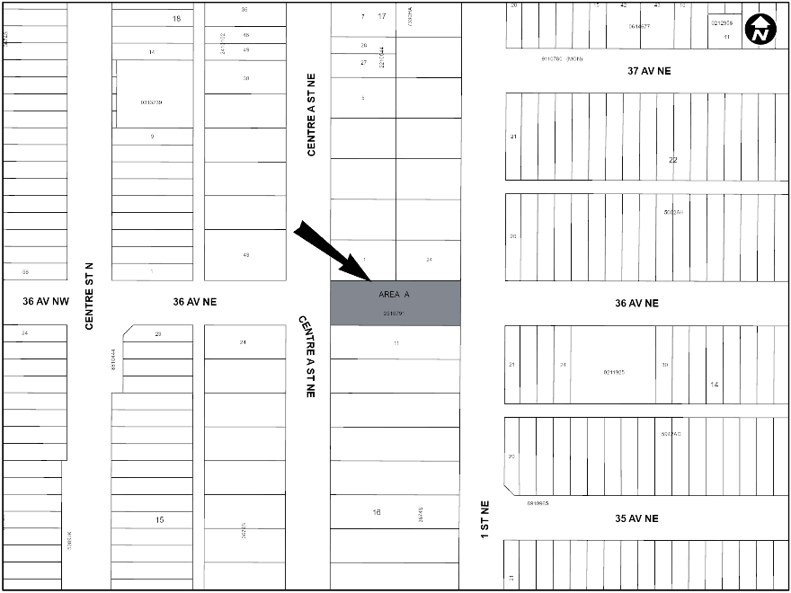
PLAN 2510791, AREA ‘A’
LOC2024-0139
LAND USE REDESIGNATION
BYLAW 125D2025
To redesignate the land located at 3703 and 3707 – 1 Street NE and 3620, 3624 and 3704 Centre A Street NE (Plan 7330HA, Block 17, Lots 1, 2, 23 and 24; Plan 3674S, Block 16, Lots 10 and 11) and the closed road (Plan 2510791, Area ‘A’) from Residential – Grade-Oriented Infill (R-CG) District and Undesignated Road Right-of-Way to Residential – Grade-Oriented Infill (R-CG) District, Multi-Residential – Contextual Grade-Oriented (M-CG) District and Multi-Residential – High Density Low Rise (M-H1) District.
MARTINDALE
LOC2024-0209
LAND USE REDESIGNATION
BYLAW 126D2025
To redesignate the land located at 43 Martindale Drive NE (Plan 8711334, Block 10, Lot 18) from the Special Purpose – Community Institution (S-CI) District to Multi-Residential – High Density Low Rise (M-H1) District.
LOC2024-0210
LAND USE REDESIGNATION
BYLAW 127D2025
To redesignate the land located at 61 Martindale Drive NE (Plan 8711334, Block 10, Lot 17) from the Special Purpose – Community Institution (S-CI) District to Direct Control (DC) District to accommodate a multi-residential development and social organization use.
RENFREW
LOC2024-0259
ROAD CLOSURE
BYLAW 9C2025
The City of Calgary intends pursuant to s.22 of the Municipal Government Act to consider bylaws to close from use and sell or hold those portions of the streets, roads, lanes or public highways described
PLAN 2510893, AREA ‘A’
LOC2024-0259
LAND USE REDESIGNATION
BYLAW 124D2025
To redesignate the land located at 956 Radnor Avenue NE and closed road (Plan 4221GL, Block 24, Lots 1, 2 and 3; Plan 2510893, Area ‘A’) from Residential – Grade-Oriented Infill (R-CG) District and Undesignated Road Right-of-Way to Multi-Residential – Contextual Medium Profile (M-C2f1.5) District.
SADDLE RIDGE
LOC2024-0295
LAND USE REDESIGNATION
BYLAW 123D2025
To redesignate the land located at #2000, 4715 – 88 Avenue NE (Condominium Plan 2310289, Unit 2) from Commercial – Neighbourhood 2 (C-N2) District to Multi-Residential – Medium Profile Support Commercial (M-X2) District.
LOC2024-0288
LAND USE REDESIGNATION
BYLAW 131D2025
To redesignate the land located at 8604 – 38 Street NE (Plan 1612881, Block 2, Lot 7) from Industrial – General (I-G) District to Direct Control (DC) District to accommodate regional commercial development.
LOC2024-0288
AMENDMENT TO THE SADDLE RIDGE AREA STRUCTURE PLAN
BYLAW 56P2025
The amendments to the Saddle Ridge Area Structure Plan are proposed in order to allow for large scale regional commercial to be developed at 8604 – 38 Street NE. The amendments introduce policies for building and site design of large scale regional commercial development. This policy amendment is in conjunction with the proposed land use redesignation for the site (Bylaw 131D2025). For further information, please contact 403-850-5301.
LOC2024-0267
LAND USE REDESIGNATION
BYLAW 132D2025
To redesignate the land located at 4515 – 84 Avenue NE (Plan 6778AW, Block 17) from Special Purpose – Future Urban Development (S-FUD) District to Residential – Low Density Mixed Housing District (R-G) District, Residential – Low Density Mixed Housing District (R-Gm) District and Special Purpose – School, Park and Community Reserve (S-SPR) District.
SW
BANKVIEW
LOC2024-0144
LAND USE REDESIGNATION
BYLAW 117D2025
To redesignate the land located at 1920, 1924, 1928, 1932, 1936, 1940, 1944 and 1948 – 26 Avenue SW (Plan 8997GC, Block 17, Lots 5 to 12) from Residential – Grade-Oriented Infill (R-CG) District to Direct Control (DC) District to accommodate minimum density.
BELTLINE
LOC2024-0047
LAND USE REDESIGNATION
BYLAW 101D2025
To redesignate the land located at 125 – 14 Avenue SW and 1400, 1410 and 1412 – 1 Street SW (Plan 9111729, Block 1, Lots 1 to 4) from Centre City Commercial Corridor District (CC-COR) and Direct Control (DC) District to Direct Control (DC) District to accommodate mixed-use development.
LOC2024-0047
AMENDMENT TO THE BELTLINE AREA REDEVELOPMENT PLAN
BYLAW 51P2025
The proposed amendments to the Beltline Area Redevelopment Plan will update both the Land Use Concept Map (Map 3) and Density Areas Map (Map 5) to ensure that the full subject site will be within the ‘Urban Mixed-Use’ area, specifically ‘Area B’. In addition, Table 4.2, ‘Floor Plate Size Restrictions’, has been updated to include a revised floor plate area of up to 800.0 square metres specific to the subject site (Plan 9111729, Block 1, Lots 1 to 4). The policy amendment is in conjunction with the proposed land use redesignation for the sites (Bylaw 101D2025). For further information, please contact 403-268-1451.
DOWNTOWN COMMERCIAL CORE
LOC2025-0047
LAND USE REDESIGNATION
BYLAW 119D2025
To redesignate the land located at 311 and 311R – 8 Street SW (Plan A1, Block 11, Lots 6 to 15) from Direct Control (DC) District to Direct Control (DC) District to accommodate a mixed-use development.
KILLARNEY/GLENGARRY
LOC2025-0021
LAND USE REDESIGNATION
BYLAW 103D2025
To redesignate the land located at 3209 – 28 Street SW (Plan 5661O, Block 53, Lots 25 and 26) from Direct Control (DC) District to Residential – Grade-Oriented Infill (R-CG) District.
LOC2025-0043
LAND USE REDESIGNATION
BYLAW 109D2025
To redesignate the land located at 3027 – 34 Street SW (Plan 732GN, Block 7, Lot 17) from Direct Control (DC) District to Residential – Grade-Oriented Infill (R-CG) District.
MANCHESTER
LOC2024-0235
LAND USE REDESIGNATION
BYLAW 99D2025
To redesignate the land located at 4336 and 4344 Macleod Trail SW (Plan 9212019, Block 1, Lots 22A and 27A) from Direct Control (DC) District to Mixed Use – General (MU-1f8.0h90) District.
MANCHESTER INDUSTRIAL
LOC2024-0271
LAND USE REDESIGNATION
BYLAW 105D2025
To redesignate the land located at 203, 209 and 211 – 60 Avenue SW, 220 – 61 Avenue SW, 6120, 6126 and 6130 – 3 Street SW (Plan 379FS, Parcel A; Plan 4880AJ, Block 16; Plan 1923GM, Block 16, Lots 1 to 6; Plan 1923GM, Block 16, OT) from Direct Control (DC) District to Mixed Used – General (MU-1f6.0h75) District and Mixed Used – General (MU-1f10.0h150) District.
LOC2024-0319
LAND USE REDESIGNATION
BYLAW 114D2025
To redesignate the land located at 6100 Macleod Trail SW (Plan 9210444, Block H, Lot 2) from Direct Control (DC) District to Mixed Use – General (MU-1f8.0h110) District.
RICHMOND
LOC2024-0292
LAND USE REDESIGNATION
BYLAW 112D2025
To redesignate the land located at 2822 – 25 Street SW (Plan 5661O, Block 47, Lots 11 to 17) from Residential – Grade-Oriented Infill (R-CG) District to Mixed Use – General (MU-1f4.0h24) District.
LOC2024-0264
LAND USE REDESIGNATION
BYLAW 118D2025
To redesignate the land located at 2604 and 2608 – 24 Street SW (Plan 8997CG, Block 4, Lots 12 and 13) from Residential – Grade-Oriented Infill (R-CG) District to Direct Control (DC) District to accommodate minimum density.
SHAGANAPPI
LOC2024-0278
LAND USE REDESIGNATION
BYLAW 106D2025
To redesignate the land located at 1408 – 33 Street SW (Plan 2084GQ, Block 4, Lot 15) from Multi-Residential – Contextual Medium Profile (M-C2) District to Mixed Use – General (MU-1f4.0h24) District.
SOUTH CALGARY
LOC2024-0265
LAND USE REDESIGNATION
BYLAW 129D2025
To redesignate the land located at 2101, 2123 and 2127 – 33 Avenue SW (Plan 4479P, Block 70, Lots 1 to 14) from Mixed Use – Active Frontage District (MU-2f3.0h23) to Direct Control (DC) District to accommodate a mixed-use development.
SPRINGBANK HILL
LOC2024-0153
LAND USE REDESIGNATION
BYLAW 111D2025
To redesignate the land located at 2435 – 81 Street SW, 2435R – 81 Street SW, 351R Springcreek Circle SW and 363 Springcreek Circle SW (Plan 3056AC, Block 20 and Plan 2310494, Block 34, Lots 5MR, 8MR, and 6PUL) from Residential – Low Density Mixed Housing (R-G) District, Special Purpose – City and Regional Infrastructure (S-CRI) District and Special Purpose – School, Park and Community Reserve (S-SPR) District to Multi-Residential – Low Profile (M-1d77) District, Residential – Low Density Mixed Housing (R-G) District, Special Purpose – School, Park and Community Reserve (S-SPR) District and Special Purpose – City and Regional Infrastructure (S-CRI) District.
LOC2024-0153
AMENDMENT TO THE SPRINGBANK HILL AREA STRUCTURE PLAN
BYLAW 53P2025
The proposed amendment to the Springbank Hill Area Structure Plan would change the land use policy for the site located at 2435 – 81 Street SW from Low Density Contextual and Low Density to Low Density and Medium Density. This proposed policy amendment is in conjunction with the proposed land use redesignation for the site (Bylaw 111D2025). For further information, please contact 587-572-7491.
WEST SPRINGS
LOC2024-0283
LAND USE REDESIGNATION
BYLAW 115D2025
To redesignate the land located at 740, 760 and 780 – 81 Street SW and 741 and 761 – 78 Street SW (Plan 4740AK, Blocks 55 to 58; Plan 2412294, Block 50, Lot 2) from Multi-Residential – High Density Low Rise (M-H1) District, Mixed Use – Active Frontage (MU-2f4.0h30) District, Mixed Use – Active Frontage (MU-2f5.0h30) District and Mixed Use – General (MU-1f4.0h30) District to Mixed Use – Active Frontage (MU-2f6.0h63) District, Mixed Use – Active Frontage (MU-2f5.0h63) District, Mixed Use – Active Frontage (MU-2f4.0h30) District, Mixed Use – General (MU-1f5.0h42) District, Mixed Use – General (MU-1f4.0h42) District, Mixed Use – General (MU-1f4.0h30) District and Mixed Use – General (MU-1f4.0h26) District.
LOC2024-0283
AMENDMENT TO THE WEST SPRINGS AREA STRUCTURE PLAN
BYLAW 54P2025
The proposed amendments to the West Springs Area Redevelopment establish a Housing Diversity Special Policy boundary to encourage non-market housing forms (replace the Land Use Concept Map). In addition, proposed amendments are to add density (Map 4) and height (Map 5) to be replaced. This proposed policy amendment is in conjunction with the proposed land use redesignation for the site (Bylaw 115D2025). For further information, please contact 587-284-2881.
SE
BELVEDERE
LOC2022-0232
LAND USE REDESIGNATION
BYLAW 113D2025
To redesignate the land located at 2498 – 100 Street SE (Portion of NW1/4 Section 8-24-28-4) from Special Purpose – Future Urban Development (S-FUD) District to Residential – Low Density Mixed Housing (R-G) District, Residential – Low Density Mixed Housing (R-Gm) District, Multi-Residential – At Grade Housing (M-G) District and Special Purpose – School, Park and Community Reserve (S-SPR) District.
LOC2024-0321
LAND USE REDESIGNATION
BYLAW 130D2025
To redesignate the land located at 2313 and 2313R – 84 Street SE (portion of NE1/4 Section 1224-29-4; a portion of Plan 8511085, OT) from Residential – Low Density Mixed Housing (R-G) District, Residential – Low Density Mixed Housing (R-Gm) District, Multi-Residential – Medium Profile (M-2) District, Special Purpose – School, Park and Community Reserve (S-SPR) District and Special Purpose – City and Regional Infrastructure (S-CRI) District to Residential – Low Density Mixed Housing (R-G) District, Multi-Residential – Medium Profile (M-2) District, Special Purpose – School, Park and Community Reserve (S-SPR) District, and Direct Control (DC) District to accommodate residential development.
DOVER
LOC2025-0015
LAND USE REDESIGNATION
BYLAW 102D2025
To redesignate the land located at 2805 – 28 Avenue SE (Plan 2411637, Block 1, Lot 1) from Multi-Residential – Contextual Grade-Oriented (M-CGd30) District to Multi-Residential – Contextual Low Profile (M-C1) District.
DOWNTOWN COMMERCIAL CORE
LOC2024-0255
ROAD CLOSURE
BYLAW 8C2025
The City of Calgary intends pursuant to s.22 of the Municipal Government Act to consider bylaws to close from use and sell or hold those portions of the streets, roads, lanes or public highways described here.
PLAN 2510830, AREA ‘A’
LOC2024-0255
LAND USE REDESIGNATION
BYLAW 120D2025
To redesignate the land located at 201 and 215 – 8 Avenue SE and the closed road (Plan A, Block 61, Lots 1 to 16 and 21 to 40; Plan 2510830, Area ‘A’) from Commercial Residential District (CR20 – C20/R20) and Undesignated Road Right-of-Way to Commercial Residential District (CR20 – C20/R20) and Direct Control (DC) District to accommodate an at-grade Plus 15 pedestrian walkway.
FAIRVIEW
LOC2024-0168
LAND USE REDESIGNATION
BYLAW 98D2025
To redesignate the land located at 8003 Fairmount Drive SE (Plan 3323HR, Block 10, Lot 16) from Housing – Grade Oriented (H-GO) District to Direct Control (DC) District to accommodate a Child Care Service.
MCKENZIE TOWNE
LOC2025-0029
LAND USE REDESIGNATION
BYLAW 108D2025
To redesignate the land located at 48 Elgin Terrace SE (Plan 0713338, Block 44, Lot 2) from Direct Control (DC) District to Residential – Low Density Mixed Housing (R-G) District.
OGDEN
LOC2025-0074
AMENDMENT TO THE MILLICAN-OGDEN AREA REDEVELOPMENT PLAN
BYLAW 52P2025
The proposed amendments to the Millican-Ogden Area Redevelopment Plan would change the land use policy for the site located at 7414 Ogden Road SE from ‘Low Density Conservation’ to ‘Low or Medium Density Multi-Dwelling Residential’ and aligns the policy with the site’s Land Use designation of Residential – Grade-Oriented Infill (R-CG) District. For further information, please contact 403-690-6315
RAMSAY
LOC2024-0304
AMENDMENT TO THE RAMSAY AREA REDEVELOPMENT PLAN
BYLAW 49P2025
The proposed amendment to the Ramsay Area Redevelopment Plan would change the land use policy for the site located at 1910 Alexander Street SE from ‘Low Density Residential’ to ‘Low Density Multi-Unit Residential.’ The proposed policy amendment is required to support a development permit application and to align the policies of the Ramsay Area Redevelopment Plan with the current Residential – Grade-Oriented Infill (R-CG) District. For further information, please contact 587-223-3019.
LOC2024-0260
LAND USE REDESIGNATION
BYLAW 100D2025
To redesignate the land located at 706 and 710 Burns Avenue SE (Plan 0711842; Block 9; Lots 42 and 43) from Residential – Grade-Oriented Infill (R-CG) District to Multi-Residential – Contextual Grade-Oriented (M-CGd80) District.
LOC2024-0260
AMENDMENT TO THE RAMSAY AREA REDEVELOPMENT PLAN
BYLAW 50P2025
The proposed amendment to the Ramsey Area Redevelopment Plan would change the land use policy for the site located at 706 and 710 Burns Avenue from Low Density Residential to Low Density Multi Unit Residential to allow for this site to be redeveloped into a multi-residential development. This proposed policy amendment is in conjunction with the proposed land use redesignation for the site (Bylaw 100D2025). For further information, please contact 403-561-6946.
LOC2025-0019
LAND USE REDESIGNATION
BYLAW 116D2025
To redesignate the land located at 1016, 1018, 1020, 1022, 1024 and 1026 – 8 Street SE (Plan A2, Block 15, lots 11 to 17) from Residential – Grade-Oriented Infill (R-CG) District to Housing – Grade Oriented (H-GO) District.
LOC2025-0019
AMENDMENT TO THE RAMSAY AREA REDEVELOPMENT PLAN
BYLAW 55P2025
The proposed amendment to the Ramsay Area Redevelopment Plan is to accommodate grade-oriented townhouse development located at 1016, 1018, 1020, 1022, 1024 and 1026 – 8 Street SE. The proposed map amendment from Low Density Residential to Medium Density Residential is required to support this proposal. The policy amendment is in conjunction with the proposed land use redesignation for the sites (Bylaw 116D2025). For further information, please contact 403-200-8575.
SHEPARD INDUSTRIAL
LOC2025-0022
LAND USE REDESIGNATION
BYLAW 110D2025
To redesignate the land located at 2787 – 86 Avenue SE (Plan 0112703, Block 1, Lot 1) from Mixed Use – General (MU-1f3.5h50) District and Special Purpose – School, Park and Community Reserve (S-SPR) District to Special Purpose – School, Park and Community Reserve (S-SPR) District and Mixed Use – General (MU-1f3.5h50) District.
SOUTHVIEW
LOC2024-0174
LAND USE REDESIGNATION
BYLAW 107D2025
To redesignate the land located at 2805, 2825, 2875 and 2919 – 17 Avenue SE (Portion of NE1/4 Section 9-24-29-W4M; Plan 732GF, Block 10) from the Mixed Use – Active Frontage (MU-2f2.0h10) District to the Mixed Use – Active Frontage (MU-2f8.0h80) District.
CITYWIDE
IP2025-0471
AMENDMENTS TO THE MUNICIPAL DEVELOPMENT PLAN
BYLAW 57P2025
This proposed targeted amendments to the Municipal Development Plan reflect provincial direction which rescinded the Growth Plan and the Regional Evaluation Framework for the Calgary Metropolitan Region while also address the disbandment of the Calgary Regional Metropolitan Board. The amendments also support the implementation of Council-approved Connect: Calgary’s Parks Plan (“Connect”).
Through Ministerial Order MSD:017/25, the province rescinded the Growth Plan and the Regional Evaluation Framework for the Calgary Metropolitan Region. During the same time, the Calgary Regional Metropolitan Board voted to disband their operations as of 2025, May 1. These actions resulted in the need to update and align the Municipal Development Plan by removing references to the Calgary Metropolitan Regional Board and its respective planning documents. The updates provide clarity for Administration, industry, applicants and other plan users around the updated regional context and considerations for land use planning.
Similarly, the proposed amendments align with Council’s decision to approve Connect: Calgary’s Parks Plan on 2025 May 27. The proposed updates ensure that both the Municipal Development Plan and Connect have common definitions and reflect the same park system categories ensuring that Administration, industry, applicants and other plan users have clear direction on parks planning considerations. For further information, contact 403-554-7023.
May 8 public hearing
NW
AMBLERIDGE
LOC2024-0157
LAND USE REDESIGNATION
BYLAW 74D2025
To redesignate the land located at 2828 ‒ 144 Avenue NW, 14800 Symons Valley Road NW and 15333 ‒ 24 Street NW (Portions of Section 6-26-1-5) from Special Purpose – Future Urban Development (S-FUD) District to Residential – Low Density Mixed Housing (R-G) District, Residential – Low Density Mixed Housing (R-Gm) District, Multi-Residential – At Grade Housing (M-G) District, Special Purpose – School, Park and Community Reserve (S-SPR) District, Special Purpose – City and Regional Infrastructure (S-CRI) District and Special Purpose – Urban Nature (S-UN) District.
HASKAYNE
LOC2025-0052
ROAD CLOSURE
BYLAW 7C2025
The City of Calgary intends pursuant to s.22 of the Municipal Government Act to consider bylaws to close from use and sell or hold those portions of the streets, roads, lanes or public highways described here.
LOC2025-0052
LAND USE REDESIGNATION
BYLAW 81D2025
To redesignate the closed road between sections NW ¼ 12 and SW ¼ 13, TWP 25, RGE 3, W5M, SW ¼ 13 and SE ¼ 14, TWP 25, RGE 3, W5M, portion of road plan 7410769 adjacent to 9000 – 149 Street NW (Plan 2510627, Areas ‘A’ and ‘B’) from Undesignated Road Right-of-Way to Special Purpose – Urban Nature (S-UN) District.
HIGHLAND PARK
LOC2024-0177
LAND USE REDESIGNATION
BYLAW 75D2025
To redesignate the land located at 119, 123, 127 and 131 – 41 Avenue NW (Plan 6482GN, Block 2, Lots 18 to 21) from Multi-Residential – Contextual Low Profile (M-C1) District to Multi-Residential – High Density Low Rise (M-H1f3.0h23d270) District.
SUNNYSIDE
LOC2024-0126
LAND USE REDESIGNATION
BYLAW 76D2025
To redesignate the land located at 122, 124 and 126 – 10 Street NW (Plan 2448O, Block 1, Lots 4, 5 and 6) from Commercial – Corridor 1 f2.8h13 (C-COR1f2.8h13) District to Mixed Use – Active Frontage (MU-2f7.0h40) District.
NE
HIGHLAND PARK
LOC2024-0307
LAND USE REDESIGNATION
BYLAW 73D2025
To redesignate the land located at 4220 Centre Street NE (Plan 6482GN, Block 10, Lot 1) from Residential – Grade-Oriented Infill (R-CG) District to Mixed Use – General (MU-1f4.0h21) District.
SW
ALTADORE
LOC2023-0025
LAND USE REDESIGNATION
BYLAW 78D2025
To redesignate the land located at 3926 – 16 Street SW (Plan 4890AG, Block A, Lots 12 and 13) from Residential – Grade-Oriented Infill (R-CG) District to Commercial – Neighbourhood 2 (C-N2) District.
LOC2023-0025
AMENDMENT TO THE SOUTH CALGARY/ALTADORE AREA REDEVELOPMENT PLAN
BYLAW 40P2025
The proposed amendment to the South Calgary/Altadore Area Redevelopment would change the land use policy for the site located at 3926 – 16 Street SW from Residential Conservation to Local Commercial. This proposed policy amendment is in conjunction with the proposed land use redesignation for the site (Bylaw 78D2025). For further information, please contact 403-268-5344.
BELTLINE
LOC2024-0202
ROAD CLOSURE
BYLAW 6C2025
The City of Calgary intends pursuant to s.22 of the Municipal Government Act to consider bylaws to close from use and sell or hold those portions of the streets, roads, lanes or public highways described here.

LOC2024-0202
LAND USE REDESIGNATION
BYLAW 72D2025
To redesignate the closed road (Plan 2510265) adjacent to 1121 – 12 Avenue SW from Undesignated Road Right-of-Way to Special Purpose – Community Service (S-CS) District.
LOC2024-0202
AMENDMENT TO THE BELTLINE AREA REDEVELOPMENT PLAN
BYLAW 39P2025
This proposal is to amend Part 1 of the Beltline Area Redevelopment Plan in order to accommodate a public park within the public road right-of-way adjacent to 1121 - 12 Avenue SW. The amendment will apply the Public Park, Pathways, Open Space & Recreation land use category to the site to enable the creation of a new park. This amendment is associated with the proposed road closure and land use change for this site (Bylaws 6C2025 and 72D2025). For further information, please contact 587-576-1845.
CURRIE BARRACKS
LOC2024-0224
LAND USE REDESIGNATION
BYLAW 79D2025
To redesignate the land located at 110 Bishop Way SW (Portion of Plan 1612440, Block 5, Lot 3) from Direct Control (DC) District to Direct Control (DC) District to accommodate the additional uses of health care service and retail drive through.
EVERGREEN
LOC2024-0263
LAND USE REDESIGNATION
BYLAW 70D2025
To redesignate the land located at 321 Everridge Drive SW (Plan 0512971, Block 15, Lot 27) from Residential – Low Density Mixed Housing (R-G) District to Direct Control (DC) District to accommodate a Child Care Service use.
KILLARNEY/GLENGARRY
LOC2024-0289
LAND USE REDESIGNATION
BYLAW 71D2025
To redesignate the land located at 3227 Kenmare Crescent SW (Plan 732GN, Block 1, Lot 45) from Direct Control (DC) District to Residential – Grade-Oriented Infill (R-CG) District.
SE
FAIRVIEW INDUSTRIAL
LOC2024-0285
LAND USE REDESIGNATION
BYLAW 77D2025
To redesignate the land located at 550 – 71 Avenue SE (Plan 5165JK, Block A) from Industrial – General (I-G) District to Direct Control (DC) District to accommodate additional support commercial uses.
OGDEN
LOC2024-0302
LAND USE REDESIGNATION
BYLAW 80D2025
To redesignate the land located at 6240 – 18A Street SE (Plan 2515AM, Block 2, Lots 27 and 28) from Residential – Grade-Oriented Infill (R-CG) District to Housing – Grade Oriented (H-GO) District.
LOC2024-0302
AMENDMENT TO THE MILLICAN-OGDEN AREA REDEVELOPMENT PLAN
BYLAW 41P2025
The proposed text amendment to the Millican-Ogden Area Redevelopment Plan would align the density allotted through the H-GO District for this site located at 6420 – 18A Street SE with the Area Redevelopment Plan. This proposed text amendment is in conjunction with the proposed land use redesignation for the site (Bylaw 80D2025). For further information, please contact 587-215-2730.
RICARDO RANCH
LOC2025-0049
LAND USE REDESIGNATION
BYLAW 82D2025
To redesignate the land located at 21209 – 72 Street SE (Portion of NE1/4 Section 10-22-29-4) from Special Purpose – Recreation (S-R) District to Direct Control (DC) District to accommodate a Temporary Sales Centre.
CITYWIDE
IP2025-0281
WEST ELBOW COMMUNITIES LOCAL AREA PLAN
BYLAW 42P2025
TO ADOPT A NEW WEST ELBOW COMMUNITIES LOCAL AREA PLAN AND REPEAL, by bylaw, the Bankview Area Redevelopment Plan, Cliff Bungalow Area Redevelopment Plan, Erlton Area Redevelopment Plan, Lower Mount Royal Area Redevelopment Plan, Marda Loop Area Redevelopment Plan, Mission Area Redevelopment Plan, Richmond Area Redevelopment Plan, South Calgary/Altadore Area Redevelopment Plan, Sunalta Area Redevelopment Plan, and Upper Mount Royal Area Redevelopment Plan; and RESCIND, by resolution, the CFB East Community Plan.
Completion of work that commenced in Fall 2022 is resulting in the repeal of the existing Bankview Area Redevelopment Plan, Cliff Bungalow Area Redevelopment Plan, Erlton Area Redevelopment Plan, Lower Mount Royal Area Redevelopment Plan, Marda Loop Area Redevelopment Plan, Mission Area Redevelopment Plan, Richmond Area Redevelopment Plan, South Calgary/Altadore Area Redevelopment Plan, Sunalta Area Redevelopment Plan, and Upper Mount Royal Area Redevelopment Plan, and the rescinding of the R CFB East Community Plan and the adoption of a new West Elbow Communities Local Area Plan (Plan). The proposed Plan outlines a comprehensive vision and policies to guide new development and investment for the sixteen communities that comprise the West Elbow Communities for the coming decades. The proposed Plan will provide greater certainty for community members, developers and industry, and decision-makers.
To learn more the West Elbow Communities Local Area Plan, please visit calgary.ca/WestElbow or email the project team at WestElbow.Plan@Calgary.ca.
IP2025-0281
AMENDMENTS TO THE LAND USE BYLAW (1P2007)
BYLAW 43P2025
Amendments to Land Use Bylaw 1P2007 maps will implement new Heritage Guidelines Areas that align with the LAP within the communities of Bankview, Cliff Bungalow, Elbow Park, Lower Mount Royal, Mission, Rideau Park, Roxboro, Scarboro, South Calgary, Sunalta and Upper Mount Royal. Rules under the Land Use Bylaw do not allow the permitted uses of Contextual Single Detached Dwelling and Semi-detached Dwelling in Heritage Guideline Areas. These amendments enable the implementation of associated West Elbow Communities Heritage Guidelines policies through the discretionary development permit review process.
To view a map of affected parcels with an accompanying list of addresses visit http://engage.calgary.ca/westelbowplan/heritageguidelines
For more information, please contact Michele Bussiere at michele.bussiere@calgary.ca.
IP2025-0251
AMENDMENTS TO THE LAND USE BYLAW (1P2007)
BYLAW 44P2025
This bylaw proposes 13 housekeeping amendments to Land Use Bylaw (LUB) 1P2007 to address recurring issues identified during the planning application process. These changes improve clarity, consistency, and efficient application processes. The amendments include:
- Rear setback rules in R-G.
- Aligning parcel coverage and private garage rules in H-GO and R-CG.
- Removing the requirement for mobility storage lockers.
- Secondary suites in multi-residential districts.
- Landscaping rules in H-GO.
- Fence rules in R-CG.
- Textual clarity for notification of decision for development permits.
- Textual error in sections 1126 (3).
- Removal of expired text.
- Overnight stays in health care services.
- Update to special function – class 1.
- Removing the requirement for a public hearing for child-care service in an existing building.
- Reduce bike parking requirements in multi-residential districts.
These amendments will improve consistency and efficiency of the LUB while reducing barriers. For further information please contact the Planning Service Centre 403-268-5311 or visit https://www.calgary.ca/housekeepingamendments.
April 8 public hearing
NW
BANFF TRAIL
LOC2024-0279
LAND USE REDESIGNATION
BYLAW 53D2025
To redesignate the land located at 2364 – 23 Street NW (Plan 9110GI, Block 6, Lot 16) from Residential – Grade-Oriented Infill (R-CG) District to Direct Control (DC) District to accommodate multi-residential development.
LOC2024-0296
LAND USE REDESIGNATION
BYLAW 61D2025
To redesignate the land located at 2636 Capitol Hill Crescent NW (Plan 2846GW, Block 5, Lot 7) from Residential – Grade-Oriented Infill (R-CG) District to Housing – Grade Oriented (H-GO) District.
PARKDALE
LOC2024-0246
LAND USE REDESIGNATION
BYLAW 52D2025
To redesignate the land located at 503 – 35 Street NW (Plan 8321AF, Block 44, portions of Lots 15 and 16) from Residential – Grade-Oriented Infill (R-CG) District to Housing – Grade Oriented (H-GO) District.
NE
CRESCENT HEIGHTS
LOC2024-0281
AMENDMENT TO THE BRIDGELAND-RIVERSIDE AREA REDEVELOPMENT PLAN
BYLAW 31P2025
The proposed amendment to the Bridgeland-Riverside Area Redevelopment Plan would change the land use policy for the site located at 411 and 413 – 2 Avenue NE to exempt parking restrictions within the Family Oriented Redevelopment Area. For further information, please contact 368-995-2048.
SADDLE RIDGE
LOC2024-0127
LAND USE REDESIGNATION
BYLAW 59D2025
To redesignate the land located at 5029 and 5119 – 84 Avenue NE and 5220 – 80 Avenue NE (Plan 6778AW, Blocks 22, 23 and 25) from Special Purpose – Future Urban Development (S FUD) District to Multi-Residential – Low Profile (M-1) District, Residential – Low Density Mixed Housing District (R-G) District, Special Purpose – School, Park and Community Reserve (S-SPR) District and Direct Control (DC) District to accommodate specific setback and height rules for Multi-Residential Development.
LOC2024-0127
AMENDMENTS TO THE SADDLE RIDGE AREA STRUCTURE PLAN
BYLAW 34P2025
Map amendments to the Saddle Ridge Area Structure Plan (ASP) are proposed in conjunction with the Outline Plan and Land Use Amendment application for the neighbourhood of Saddle Ridge. The amendments involve updating the road classification for 52 Street NE in Map 6 (Land Use Plan) and Map 7 (Proposed Northeast Transportation Network) from an Arterial Roadway to a Primary Collector. This proposed policy amendment is in conjunction with the proposed land use redesignation for the site (Bylaw 58D2025). For further information, please contact 403-268-5344.
SW
ALPINE PARK
LOC2024-0248
LAND USE REDESIGNATION
BYLAW 55D2025
To redesignate the land located at 16028 – 37 Street SW (Portion of Section 31-22-1-5, Legal Subdivision 3, 4, and 6) from Special Purpose – Future Urban Development (S-FUD) District to Special Purpose – City and Regional Infrastructure (S-CRI) District, Residential – Low Density Mixed Housing (R-G) District and Direct Control (DC) District to accommodate residential development.
LOC2024-0248
LAND USE REDESIGNATION
BYLAW 56D2025
To redesignate the land located at 16028 – 37 Street SW (Portion of Section 31-22-1-5, Legal Subdivision 3, 4, and 6) from Special Purpose – Future Urban Development (S-FUD) District to Direct Control (DC) District to accommodate commercial development.
MISSION
LOC2024-0176
LAND USE REDESIGNATION
BYLAW 57D2025
To redesignate the land located at 101 – 25 Avenue SW (Plan B1, Block 49, Lots 32 and 33, OT) from Multi-Residential – High Density Medium Rise (M-H2d160) District to Multi-Residential – High Density Medium Rise (M-H2) District.
LOC2024-0176
AMENDMENT TO THE MISSION AREA REDEVELOPMENT PLAN
BYLAW 32P2025
The proposed amendment to the Mission Area Redevelopment Plan would change the maximum permitted density for the site at 101 – 25 Avenue SW from 395 units per hectare to 463 units per hectare. This proposed policy amendment is in conjunction with the proposed land use redesignation for the site (Bylaw 56D2025). For further information, please contact 587-229-6079.
RICHMOND
LOC2023-0359
LAND USE REDESIGNATION
BYLAW 66D2025
To redesignate the land located at 2505 Richmond Road SW and 2519 Richmond Road SW (Plan 5118FQ, Block A; Plan 8598GF, Block B) from Residential – Grade-Oriented Infill (R-CG) District to Special Purpose – School, Park and Community Reserve (S-SPR) District and Direct Control (DC) District to accommodate a comprehensive transit oriented development.
LOC2023-0359
AMENDMENT TO THE WESTBROOK COMMUNITIES LOCAL AREA PLAN
BYLAW 35P2025
Proposed amendments to the Westbrook Communities Local Area Plan add new Urban From categories and Building Scale modifiers to the former Viscount Bennett/Chinook Learning Comprehensive Planning Site. The amendments identify the subject lands as ‘Neighbourhood Connector’ and ‘Parks and Open Space’. In addition, proposed Building Scale modifiers would allow for maximum building heights ranging from four-storeys to 16-storeys. Also included are amendments to the policies and map for the 26 Avenue/Crowchild Trail Transit Station Area that identify a new proposed park as well as Core and Transition Zones. These amendments are proposed to allow for this site develop into a comprehensively planned transit-oriented development. This proposed policy amendment is in conjunction with the proposed land use redesignation for the site (Bylaw 65D2025). For further information, please contact 587-229-6079.
RESIDUAL SUB-AREA 12J
LOC2024-0113
LAND USE REDESIGNATION
BYLAW 69D2025
To redesignate the land located at 16311 – 104 Street SE (Plan 0712234, Block 8, Lot 1) from Direct Control District (DC) District to Direct Control (DC) District to accommodate additional uses.
SIGNAL HILL
LOC2018-0184
LAND USE REDESIGNATION
BYLAW 65D2025
To redesignate the land located at 1919 Sirocco Drive SW (Plan 9011583, portion of Block 3), from Commercial – Community 1 (C-C1) District to Mixed Use – General (MU-1f3.0h25) District.
SPRINGBANK HILL
LOC2024-0219
LAND USE REDESIGNATION
BYLAW 67D2025
To redesignate the land located at 217 Springbluff Boulevard SW and 7545 Elkton Drive SW (Plan 252HP, Block 4; Plan 2370IB, Block 3, Lot 3) from Residential – One Dwelling (R-1s) District to Residential – Low Density Mixed Housing (R-G) District.
WEST SPRINGS
LOC2024-0218
LAND USE REDESIGNATION
BYLAW 68D2025
To redesignate the land located at 870 – 81 Street SW (Plan 4740AK, Block 42) from Residential – One Dwelling (R-1s) District to Residential – Low Density Mixed Housing (R-G) District.
SE
ACADIA
LOC2024-0140
LAND USE REDESIGNATION
BYLAW 62D2025
To redesignate the land located at 8900 Macleod Trail SE (Plan 8211147, Block 119, Lot 2) from Commercial – Corridor 3 f1.75h37 (C-COR3 f1.75h37) District to Commercial – Corridor 2 f1.75h37 (C-COR2 f1.75h37) District.
DOVER
LOC2024-0245
ROAD CLOSURE
BYLAW 5C2025
The City of Calgary intends pursuant to s.22 of the Municipal Government Act to consider bylaws to close from use and sell or hold those portions of the streets, roads, lanes or public highways described here.

PLAN 2510013, AREA ‘D’
LOC2024-0245
LAND USE REDESIGNATION
BYLAW 58D2025
To redesignate the closed road (Plan 2510013, Area ‘D’) adjacent to 3004 and 3020 – 36 Street SE from Undesignated Road Right-of-Way to Special Purpose – Community Service (S-CS) District.
FOREST LAWN
LOC2024-0266
LAND USE REDESIGNATION
BYLAW 51D2025
To redesignate the land located at 1509 – 37 Street SE (Plan 5428GG, Block 9, Lot 3) from Residential – Grade-Oriented Infill (R-CG) District to Housing – Grade Oriented (H-GO) District.
OGDEN
LOC2024-0275
AMENDMENTS TO THE MILLICAN-OGDEN AREA REDEVELOPMENT PLAN
BYLAW 33P2025
The proposed amendment to the Millican-Ogden Area Redevelopment Plan would change the land use policy for the site located at 7804 – 22 Street SE from Low Density Conservation to Low or Medium Density Multi-Dwelling Residential. This proposed policy amendment is in alignment with the existing land use district on this site. For further information, please contact 587-225-5159.
RED CARPET
LOC2024-0152
LAND USE REDESIGNATION
BYLAW 60D2025
To redesignate the land located at 901 – 68 Street SE (Condominium Plan 2010033, a portion of Unit B) from Commercial – Corridor 1 f3.0h16 (C-COR1f3.0h16) District and Multi-Residential – Contextual Grade-Oriented (M-CGd60) District to Mixed Use – Active Frontage (MU-2f4.0h24) District.
STARFIELD
LOC2024-0323
LAND USE REDESIGNATION
BYLAW 63D2025
To redesignate the land located at 5495 – 61 Avenue SE (Plan 1311314, Block 6, Lot 4) from Industrial – General (I-G) District to Direct Control (DC) District to accommodate a Temporary Shelter.
LOC2022-0169
LAND USE REDESIGNATION
BYLAW 64D2025
To redesignate the land located at 4601 – 68 Street SE (Portion of SE1/4 Section 2-24-29-4) from Special Purpose – Future Urban Development (S-FUD) District to Industrial – General (I-G) District.
SOUTHVIEW
LOC2024-0269
LAND USE REDESIGNATION
BYLAW 54D2025
To redesignate the land located at 1804 – 34 Street SE (Plan 5682GI, Block 2, Lot 19) from Commercial – Corridor 1 (C-COR1f2.5h16) District to Mixed Use – General (MU-1f4.5h23) District.
Citywide
IP2025-0072
CHINOOK COMMUNITIES LOCAL AREA PLAN
BYLAW 36P2025
Completion of work that commenced in Fall 2022 is resulting in the repeal of the existing Parkhill/Stanley Park Area Redevelopment Plan, Manchester Area Redevelopment Plan, 50 Avenue SW Area Redevelopment Plan, and the rescinding of the Revised Windsor Park Transition Area Policy Statement, Chinook Station Area Plan, and Glenmore Trail Land Use Study and the adoption of a new Chinook Communities Local Area Plan (Plan). The proposed Plan outlines a comprehensive vision and policies to guide new development and investment for the nine communities that comprise the Chinook Communities for the coming decades. The proposed Plan will provide greater certainty for community members, developers and industry, and decision-makers. For further information, please contact chinook@calgary.ca.
C2025-0321
AMENDMENT TO THE SOUTH SHAGANAPPI COMMUNITIES LOCAL AREA PLAN
BYLAW 37P2025
Following the approval of the South Shaganappi Communities Local Area Plan (Plan) at the Public Hearing Meeting of Council on 2025 March 04, Council directed Administration to prepare amendments for the portion of the block that is located on the east side of 53 Avenue NW, bordering the parks and open space to the north and having a municipal address of 5200 53 Avenue NW, and to bring a new proposed bylaw directly to the 2025 April 08 Public Hearing of Council for three readings.
Amendments to the Plan includes adding Comprehensive Planning Site to the subject site on Map 3: Urban Form, removal of building scale to the subject site on Map 4: Building Scale and adding policy requiring future Map 4: Building Scale amendment to the site in Section 2.2.5.
To learn more about these amendments, please visit Calgary.ca/Shaganappi or email the project team at South.Shaganappi@Calgary.ca.
C2025-0326
AMENDMENT TO THE RILEY COMMUNITIES LOCAL AREA PLAN
BYLAW 38P2025
Following approval of the Riley Communities Local Area Plan (Plan) at the Public Hearing Meeting of Council on 2025 March 04, Council directed Administration to prepare proposed amendments for the blocks located on the south side of 1 Avenue NW north of the lane, between 7 Street NW and 9 Street NW. These amendments would change the Urban Form Category from Neighbourhood Local to Neighbourhood Connector, and the Building Scale from Limited (up to 3 storeys) to Low (up to 6 storeys) for these two affected blocks. This will result in changes to Map 3: Urban Form and Map 4: Building Scale of the Plan.
To learn more about these amendments and the approved Plan, please visit Calgary.ca/Riley or email the project team at Riley.Plan@calgary.ca.
EC2024-1271
AMENDMENT TO THE CLEAN ENERGY IMPROVEMENT PROGRAM BYLAW
BYLAW 3M2025
The purpose of the proposed Bylaw is to amend Bylaw 53M2021, the Clean Energy Improvement Program Bylaw, an existing bylaw of The City of Calgary (“The City”) that established a Clean Energy Improvement Program under Division 6.1 of Part 10 of the Municipal Government Act, RSA 2000 c.M-26 (“MGA”).
The proposed Bylaw amendment changes the title to clarify it is a residential Clean Energy Improvement Program, authorizes The City to make an additional borrowing of up to $20,000,000 for the purpose of financing residential Clean Energy Improvements, as set out in Schedule “A” of the proposed Bylaw, and authorizes The City to impose a Clean Energy Improvement Tax in respect of each improvement made to participating properties, in order to raise the revenue to repay the costs of the Clean Energy Improvements. The indebtedness will be repaid over a period not exceeding twenty-five (25) years, with interest being calculated at an interest rate fixed by the lender on the date of the borrowing, at a rate not exceeding eight percent (8%) per annum.
EC2024-1272
COMMERCIAL CLEAN ENERGY IMPROVEMENT PROGRAM BYLAW
BYLAW 2M2025
The purpose of the proposed Bylaw is to establish a Commercial Clean Energy Improvement Program in The City of Calgary (“The City”) under Division 6.1 of Part 10 of the Municipal Government Act, RSA 2000 c. M-26 (“MGA”). The proposed Bylaw includes the conditions for eligible property owners to participate in the program and authorizes The City to enter into clean energy improvement agreements with owners of qualifying properties to allow these improvements to be made to their properties.
The proposed Bylaw also authorizes The City to make a borrowing of up to $10,000,000 for the purpose of financing Clean Energy Improvements, as defined in the proposed Bylaw, and authorizes The City to impose a Clean Energy Improvement Tax, as defined in the proposed Bylaw, on participating properties in order to raise the revenue to repay the costs of the Clean Energy Improvements. The indebtedness will be repaid over a period not exceeding twenty-five (25) years, with interest being calculated at an interest rate fixed by the lender on the date of the borrowing, at a rate not exceeding eight percent (8%) per annum.
March 4 public hearing
NW
No Northwest items
NE
CORNERSTONE
LOC2023-0219
LAND USE REDESIGNATION
BYLAW 45D2025
To redesignate the land located at 10011 ‒ 68 Street NE and 6221 Country Hills Boulevard NE (portion of SE1/4 Section 23-25-29-4; portion of NE1/4 Section 23-25-29-4) from Residential – Low Density Mixed Housing (R-G) District, Residential – Low Density Mixed Housing (R-Gm) District, Multi-Residential – At Grade Housing (M-G) District, Multi-Residential – Low Profile (M-1) District, Special Purpose – Urban Nature (S-UN) District, Special Purpose – School, Park and Community Reserve (S-SPR) District, Special Purpose – City and Regional Infrastructure (S-CRI) District and Special Purpose – Future Urban Development (S-FUD) District to Residential – Low Density Mixed Housing (R-G) District, Residential – Low Density Mixed Housing (R-Gm) District, Multi-Residential – At Grade Housing (M-G) District, Multi-Residential – Low Profile (M-1) District, Multi-Residential – Medium Profile (M-2) District, Multi-Residential – Low Profile Support Commercial (M-X1) District, Commercial – Community 1 (C-C1) District, Special Purpose – Urban Nature (S-UN) District, Special Purpose – School, Park and Community Reserve (S-SPR) District, and Special Purpose – City and Regional Infrastructure (S-CRI) District.
HUNTINGTON HILLS
LOC2024-0249
LAND USE REDESIGNATION
BYLAW 43D2025
To redesignate the land located at 6600 – 4 Street NE (Plan 8211348, Block 4, Lot 4) from Commercial – Neighbourhood 2 (C-N2) District to Commercial – Community 1 (C-C1) District.
TEMPLE
LOC2024-0185
LAND USE REDESIGNATION
BYLAW 44D2025
To redesignate the land located at 140 Templemont Circle NE (Plan 7910737, Block 49, Lot 28) from Residential – Grade-Oriented Infill (R-CG) District to Direct Control (DC) District to accommodate two secondary suites within an existing building.
SW
BRIDLEWOOD
LOC2024-0130
LAND USE REDESIGNATION
BYLAW 39D2025
To redesignate the land located at 16720 – 24 Street SW (Plan 0512405, Block 2, Lot 58) from Residential – Low Density Mixed Housing (R-G) District to Multi-Residential – Low Profile (M-1) District.
GLENDALE
LOC2024-0187
LAND USE REDESIGNATION
BYLAW 40D2025
To redesignate the land located at 4515 – 17 Avenue SW (Plan 2002GS, Block 24, Lot 28) from Residential – Grade-Oriented Infill (R-CG) District to Housing – Grade Oriented (H-GO) District.
HAYSBORO
LOC2024-0149
LAND USE REDESIGNATION
BYLAW 47D2025
To redesignate the land located at 8306 Horton Road SW (Plan 2904HQ, Blocks 1, 2 and 5) from Direct Control (DC) District to Multi-Residential – High Density Medium Rise (M-H2) District.
LOC2024-0213
LAND USE REDESIGNATION
BYLAW 20D2025
To redesignate the land located at 627 Heritage Drive SW (Plan161JK, Block 1, portion of Lot D) from Special Purpose – Recreation (S-R) District to Mixed Use – General (MU-1f3.0h25) District.
KILLARNEY/GLENGARRY
LOC2024-0247
LAND USE REDESIGNATION
BYLAW 41D2025
To redesignate the land located at 2608 – 31 Street SW (Plan 1855W, Block 2B, Lots 23 and 24) from Direct Control (DC) District to Residential – Grade-Oriented Infill (R-CG) District.
YORKVILLE
LOC2024-0104
LAND USE REDESIGNATION
BYLAW 50D2025
To redesignate the land located at 19515 Sheriff King Street SW (Portion of SE1/4 Section 16-22-1-5) from Direct Control (DC) District, Multi-Residential – High Density Low Rise (M-H1) District, Residential – Low Density Mixed Housing (R-G) District, Commercial – Corridor 3 (C-COR3f0.5h12) District, Special Purpose – School, Park and Community Reserve (S-SPR) District, Special Purpose – Urban Nature (S-UN) District and Special Purpose – City and Regional Infrastructure (S-CRI) District to Multi-Residential – High Density Low Rise (M-H1) District, Multi-Residential – Low Profile (M-1) District, Residential – Low Density Mixed Housing (R-G) District, Special Purpose – School, Park and Community Reserve (S-SPR) District, Special Purpose – City and Regional Infrastructure (S-CRI) District and Direct Control (DC) District to accommodate residential development.
LOC2024-0104
AMENDMENT TO THE WEST MACLEOD AREA STRUCTURE PLAN
BYLAW 24P2025
The proposed amendments to the West Macleod Area Structure Plan would change the land use policy for the site located at 19515 Sheriff King Street SW from Mixed Use Community Node to Residential Area and Corridor Planning Area. An additional amendment includes the relocation of the Fire Hall/EMS Site from another location within the ASP to the subject site. This proposed policy amendment is in conjunction with the proposed land use redesignation for the site (Bylaw 50D2025). For further information, please contact 403-519-4178.
SE
ALYTH/BONNYBROOK
LOC2024-0262
LAND USE REDESIGNATION
BYLAW 46D2025
To redesignate the land located at 4321 – 15 Street SE (Portion of Plan 7710607, Block C) from Industrial – Heavy (I-H) District to Special Purpose – City and Regional Infrastructure (S-CRI) District.
INGLEWOOD
LOC2024-0223
LAND USE REDESIGNATION
BYLAW 48D2025
To redesignate the land located at 1511 – 8 Avenue SE (Plan A3, Block 14, Lot 33 and a portion of Lot 32) from Residential – Grade-Oriented Infill (R-CG) District to Housing – Grade Oriented (H-GO) District.
MCKENZIE TOWNE
LOC2024-0195
LAND USE REDESIGNATION
BYLAW 37D2025
To redesignate the land located at 15192 Prestwick Boulevard SE (Plan 0010184, Block 38, Lot 63) from Direct Control (DC) District to Residential – Low Density Mixed Housing (R-G) District.
MISSION
LOC2024-0212
LAND USE REDESIGNATION
BYLAW 49D2025
To redesignate the land located at 121 – 17 Avenue SE (Plan 2011170, Block 7, Lot 42) from Direct Control (DC) District to Mixed Use – Active Frontage (MU-2f4.0h24) District.
RAMSAY
LOC2023-0270
LAND USE REDESIGNATION
BYLAW 42D2025
To redesignate the land located at 2109 – 6 Street SE (Plan 4895AC, Block C, a portion of Lot 43) from Direct Control (DC) District to Residential – Grade-Oriented Infill (R-CG) District.
LOC2023-0270
AMENDMENT TO THE RAMSAY AREA REDEVELOPMENT PLAN
BYLAW 23P2025
The proposed amendments to the Ramsay Area Redevelopment Plan would change the land use policy for a portion of the site located at 1933 – 6 Street SE from Low Density Residential to Open Space, Park, School or Community Facility. In addition, a portion of the site located at 2109 – 6 Street SE would be identified as Low Density Residential from Open Space, Park, School or Community Facility. The amendments also involve adjustments to the boundary of Sub-Area 4 and Open Space. These proposed policy amendments are in conjunction with the proposed land use redesignation for the site (Bylaw 42D2024). For further information, please contact 587-215-2730.
RED CARPET
LOC2024-0128
LAND USE REDESIGNATION
BYLAW 38D2025
To redesignate the land located at 6105 – 16A Avenue SE (Plan 0010642, Block 2, Lot 2) from Multi-Residential – Contextual Medium Profile (M-C2) District to Multi-Residential – High Density Low Rise (M-H1f2.0) District.
Citywide
IP2025-0009
ADOPT THE RILEY COMMUNITIES LOCAL AREA PLAN, REPEAL THE EXISTING HILLHURST/SUNNYSIDE AREA REDEVELOPMENT PLAN AND HOUNSFIELD HEIGHTS/BRIAR HILL AREA REDEVELOPMENT PLAN
BYLAW 25P2025
Completion of work that commenced in Spring 2022 has resulted in the proposed adoption of a new Riley Communities Local Area Plan (LAP). This will repeal the existing Hillhurst/Sunnyside Area Redevelopment Plan (1988) and Hounsfield Heights/Briar Hill Area Redevelopment Plan (1989). Council will also be considering rescinding the non-statutory North Bow Design Brief (1977). The proposed Riley Communities LAP outlines a comprehensive vision and policies to guide new development and investment throughout four residential communities now referred to as the Riley Communities for the coming decades. The proposed LAP will provide greater certainty for the community, area developers and decision-makers as it pertains to land use matters, mobility, and sustainable growth.
To learn more the Riley Communities Local Area Plan, please visit calgary.ca/riley or email the project team at riley.plan@calgary.ca.
IP2025-0009
AMENDMENT TO THE LAND USE BYLAW (1P2007)
BYLAW 26P2025
Amendments to Land Use Bylaw 1P2007 maps will implement new Heritage Guidelines Areas that align with the LAP within the communities of Hillhurst and Sunnyside. Rules under the Land Use Bylaw do not allow the permitted uses of Contextual Single Detached Dwelling and Semi-detached Dwelling in a Heritage Guideline Area. These amendments enable the implementation of associated Riley Communities Heritage Guidelines policies through the discretionary development permit review process.
To learn more about the Heritage Guidelines as it pertains to the proposed Riley Communities Local Area Plan, please visit calgary.ca/riley or email the project team at riley.plan@calgary.ca.
C2025-0124
AMENDMENTS TO THE NORTHEAST INDUSTRIAL AREA STRUCTURE PLAN
BYLAW 27P2025
The proposed amendments are to add a new land use area (Comprehensive Planning Overlay) within Section 7.0 and replace the Land Use Concept Map (Map 3) and the Land Use Constraints Map (Map 5) within the Northeast Industrial Area Structure Plan. The amendments are being proposed to allow for residential development within the northeast community of Stonegate Landing. For further information, please contact 587-576-3104.
C2025-0124
AMENDMENTS TO THE MUNICIPAL DEVELOPMENT PLAN
BYLAW 28P2025
The proposed amendments are to replace Volume 1, Map 1 entitled ‘Urban Structure’ and Volume 3 (Calgary Transportation Plan), Map 5 entitled ‘Primary Goods Movement Network’ within the Municipal Development Plan. The amendments are being proposed to allow for residential development within the northeast community of Stonegate Landing. For further information, please contact 587-576-3104.
IP2024-1066
SOUTH SHAGANAPPI COMMUNITIES LOCAL AREA PLAN
BYLAW 29P2025
Completion of work that commenced in Fall 2022 is resulting in the repeal of the existing Banff Trail Area Redevelopment Plan, Banff Trail Station Area Redevelopment Plan, Montgomery Area Redevelopment Plan, Parkdale Neighbourhood Activity Centre Area Redevelopment Plan, Stadium Shopping Centre Area Redevelopment Plan, the rescinding of the Bowmont Design Brief, South Shaganappi Communities Area Plan, Parkdale Special Planning Study, Varsity Community Special Study, Varsity Design Brief (also referred to as Varsity Acres Design Brief), and Varsity Land Use Study and the adoption of a new South Shaganappi Communities Local Area Plan (Plan). The proposed Plan outlines a comprehensive vision and policies to guide new development and investment for the nine communities that comprise the South Shaganappi Communities for the coming decades. The proposed Plan will provide greater certainty for community members, developers and industry, and decision-makers for when future development and investment occur.
To learn more the South Shaganappi Communities Local Area Plan, please visit calgary.ca/Shaganappi or email the project team at south.shaganappi@calgary.ca.
IP2024-1066
AMENDMENTS TO THE BRENTWOOD STATION AREA REDEVELOPMENT PLAN
BYLAW 30P2025
The proposed amendments to the Brentwood Station Area Development Plan are to update the Plan Boundary to remove areas west of Crowchild Trail NW from the Plan area. These amendments are required in order to approve the South Shaganappi Communities Local Area Plan which includes the area to the west of the Brentwood LRT Station.
February 4 public hearing
NW
BANFF TRAIL
LOC2024-0205
AMENDMENT TO THE BANFF TRAIL AREA REDEVELOPMENT PLAN
BYLAW 2P2025
The proposed amendments to the Banff Trail Area Redevelopment Plan would amend the land use plan for the site located at 2015 – 28 Avenue NW from ‘Low Density Residential’ to ‘Low Density Rowhouse’. The proposed amendments would also amend the maximum building height for the site from ‘As per Land Use Bylaw’ to ‘11 metres’. For further information, please contact 587-215-1655.
LOC2024-0233
AMENDMENT TO THE BANFF TRAIL AREA REDEVELOPMENT PLAN
BYLAW 14P2025
The proposed amendments to the Banff Trail Area Redevelopment Plan would change the land use policy for the site located at 3223 Cochrane Road NW from ‘Low Density Residential’ to ‘Low Density Rowhouse’ and would change the maximum building height from ‘As Per Land Use Bylaw’ to ‘11 metres’. For further information, please contact 403-808-6189.
LOC2024-0165
LAND USE REDESIGNATION
BYLAW 30D2025
To redesignate the land located at 2406 – 23 Avenue and 2407 – 23 Street NW (Plan 9110GI, Block 4, Lots 37 and 38) from Residential – Grade-Oriented Infill (R-CG) District to Direct Control (DC) District to accommodate transit-oriented development.
MONTGOMERY
LOC2024-0237
AMENDMENT TO THE MONTGOMERY AREA REDEVELOPMENT PLAN
BYLAW 9P2025
The proposed amendment to the Montgomery Area Redevelopment would change the land use policy for the site located at 4636 – 20 Avenue NW from Low Density Residential to Low Density Residential/ Townhouse. For further information, please contact 587-582-0196.
LOC2024-0207
AMENDMENT TO THE MONTGOMERY AREA REDEVELOPMENT PLAN
BYLAW 12P2025
The proposed amendment to the Montgomery Area Redevelopment Plan would change the land use policy for the site located at 2119 Mackay Road NW from ‘Low Density Residential’ to ‘Low Density Residential/ Townhouse’. For further information, please contact 587-215-2052.
LOC2024-0208
AMENDMENT TO THE MONTGOMERY AREA REDEVELOPMENT PLAN
BYLAW 13P2025
The proposed amendment to the Montgomery Area Redevelopment Plan would change the land use policy for the site located at 2823 Mackay Road NW from ‘Low Density Residential’ to ‘Low Density Residential/ Townhouse’. For further information, please contact 587-215-2052.
LOC2024-0225
AMENDMENT TO THE MONTGOMERY AREA REDEVELOPMENT PLAN
BYLAW 15P2025
The proposed amendment to the Montgomery Area Redevelopment Plan would amend the land use policy for the site located at 4840 Montana Crescent NW from ‘Low Density Residential’ to ‘Low Density Residential/ Townhouse’. For further information, please contact 587-215-1655.
LOC2024-0239
AMENDMENT TO THE MONTGOMERY AREA REDEVELOPMENT PLAN
BYLAW 16P2025
The proposed amendment to the Montgomery Area Redevelopment Plan would change the land use policy for the site located at 1812 – 51 Street NW from ‘Low Density Residential’ to ‘Low Density Residential/ Townhouse’. For further information, please contact 587-223-2498.
PARKDALE
LOC2024-0201
LAND USE REDESIGNATION
BYLAW 31D2025
To redesignate the land located at 3407 – 3 Avenue NW (Plan 2573GE, Block 31, Lot A) from Residential – Grade-Oriented Infill (R-CG) District to Housing – Grade Oriented (H-GO) District.
TUSCANY
LOC2024-0093
LAND USE REDESIGNATION
BYLAW 26D2025
To redesignate the land located at 10 Tuscany Hills Road NW (Plan 9511068, Block 1, Lot 4) from Residential – Grade-Oriented Infill (R-CG) District to Direct Control (DC) District to accommodate a Child Care Service.
TUXEDO PARK
LOC2024-0064
LAND USE REDESIGNATION
BYLAW 28D2025
To redesignate the land located at 3103, 3105, 3111, 3115, and 3119 Centre Street NW (Plan 2617AG, Block 59, Lots 1 to 10) from Residential – Grade-Oriented Infill (R-CG) District and Direct Control (DC) District to Mixed Use – General (MU-1f3.7h23) District and Mixed Use – General (MU-1f5.5h42) District.
NE
BRIDGELAND
LOC2024-0230
AMENDMENT TO THE BRIDGELAND-RIVERSIDE AREA REDEVELOPMENT PLAN
BYLAW 17P2025
The proposed amendment to the Bridgeland-Riverside Area Redevelopment Plan would change the land use policy for the site located at 528 – 8A Street NE to allow for low-density development in the form of rowhouses, townhouses and stacked townhouses. For further information, please contact 403-215-0554.
DEERFOOT BUSINESS CENTRE
LOC2024-0211
LAND USE REDESIGNATION
BYLAW 29D2025
To redesignate the land located at 6400 – 11 Street NE (Plan 9410205, Block C, Lot 5PUL) from Special Purpose – City and Regional Infrastructure (S-CRI) District to Industrial – General (I-G) District.
RESIDUAL SUB-AREA 10E
LOC2021-0009
LAND USE REDESIGNATION
BYLAW 33D2025
To redesignate the land located at 4727R – 84 Street NE (Plan 1411635, Block 1, Lot 1) from Special Purpose – Transportation and Utility Corridor (S-TUC) District to Special Purpose – Future Urban Development (S-FUD) District.
SADDLE RIDGE
LOC2024-0229
LAND USE REDESIGNATION
BYLAW 32D2025
To redesignate the land located at #500, 669 Savanna Boulevard NE (Condominium Plan 2311176, Units 101 to 104) from Multi-Residential – Low Profile Support Commercial (M-X1d100) District to Commercial – Neighbourhood 2 (C-N2) District.
SKYVIEW RANCH
LOC2024-0044
LAND USE REDESIGNATION
BYLAW 25D2025
To redesignate the land located at 72 Skyview Shores Manor NE (Plan 1111433, Block 18, Lot 21) from Residential – Low Density Mixed Housing (R-G) District to Direct Control (DC) District to accommodate a Child Care Service.
SW
BELTLINE
LOC2024-0192
LAND USE REDESIGNATION
BYLAW 36D2025
To redesignate the land located at 1520 – 4 Street SW and 332, 338 and 340 – 17 Avenue SW (Plan 1910115, Block 120, Lot 51; Plan C, Block 120, Lots 41 to 46) from Commercial – Corridor 1 f3.0h46 (C-COR1f3.0h46) District and Direct Control (DC) District to Direct Control (DC) District to accommodate mixed-use development.
LOC2024-0192
AMENDMENT TO THE BELTLINE AREA REDEVELOPMENT PLAN
BYLAW 19P2025
The proposed amendments to the Beltline Area Redevelopment Plan will add a new Special Policy Area under Section 4.7 that outlines site specific rules for the subject parcels in relation to increased floor plate sizes, the addition of a new bonusing item that relates to improvements within the public realm and outlines the opportunity for additional density for both Areas B and D, but only as located in Special Policy Area 1 and 2. In addition, both the Land Use Concept Map (Map 3) and Density Areas Map (Map 5) will be updated to identify the location of Special Policy Areas 1 and 2 and Table 5 (Density Areas) will also be updated to outline the densities allowed within Special Policy Area 2. This proposed policy amendment is in conjunction with the proposed land use redesignation for the site (Bylaw 36D2025). For further information, please contact 403-268-1451.
BRIDLEWOOD
LOC2024-0242
LAND USE REDESIGNATION
BYLAW 18D2025
To redesignate the land located at 260 Bridlewood Avenue SW (Plan 0212796, Block 16, Lot 48) from Direct Control (DC) District to Residential – Low Density Mixed Housing (R-G) District.
CLIFF BUNGALOW
LOC2024-0220
LAND USE REDESIGNATION
BYLAW 22D2025
To redesignate the land located at 608 – 22 Avenue SW (Plan 2112AC, Block K, Lot 24) from Multi-Residential – Contextual Grade-Oriented (M-CGd72) District to Multi-Residential – Contextual Medium Profile (M-C2) District.
LOC2024-0220
AMENDMENT TO THE CLIFF BUNGALOW AREA REDEVELOPMENT PLAN
BYLAW 10P2025
The proposed amendment to the Cliff Bungalow Area Redevelopment Plan would change the land use policy for the site located at 602 – 22 Avenue SW from Conservation and Infill to Medium Density. This proposed policy amendment is in conjunction with the proposed land use redesignation for the site (Bylaw 22D2025). For further information, please contact 403-816-2735.
LINCOLN PARK
LOC2024-0163
LAND USE REDESIGNATION
BYLAW 34D2025
To redesignate the land located at 5116 Richard Road SW (Plan 1410343, Block 1, Lot 9) from Direct Control (DC) District to Mixed Use – General (MU-1f3.0h32) District.
HAYSBORO
LOC2024-0213
LAND USE REDESIGNATION
BYLAW 20D2025
To redesignate the land located at 627 Heritage Drive SW (Plan161JK, Block 1, portion of Lot D) from Special Purpose – Recreation (S-R) District to Mixed Use – General (MU-1f3.0h25) District.
MEDICINE HILL
LOC2024-0147
LAND USE REDESIGNATION
BYLAW 35D2025
To redesignate the land located at 1024 Na’a Drive SW (Plan 1612946, Block 3, Lot 1) from Direct Control (DC) District to Direct Control (DC) District to accommodate a Self Storage Facility.
SE
INGLEWOOD
LOC2024-0095
LAND USE REDESIGNATION
BYLAW 21D2025
To redesignate the land located at 914 – 11 Street SE (Plan 0813035, Block 1, Lot 37) from Commercial – Corridor 2 f2.8h12 (C-COR2 f2.8h12) District to Direct Control (DC) District to accommodate General Industrial – Light.
RAMSAY
LOC2023-0257
LAND USE REDESIGNATION
BYLAW 27D2025
To redesignate the land located at 1117, 1121, 1123 and 1125 – 8 Street SE and 1120 Maggie Street SE (Plan A2, Block 17, Lots 15 to 19) from Residential – Grade-Oriented Infill (R-CG) District to Direct Control (DC) District to accommodate grade-oriented development.
LOC2023-0257
AMENDMENT TO THE RAMSAY AREA REDEVELOPMENT PLAN
BYLAW 18P2025
The proposed amendment to the Ramsay Area Redevelopment Plan is to accommodate grade-oriented residential development located at 1117, 1121, 1123, 1125 - 8 Street SE and 1120 Maggie Street SE. This proposed policy amendment is provided to enhance the subject site’s development interface on 8 Street SE and Maggie Street SE and to encourage development to incorporate building design reference from the nearby heritage assets. The policy amendment is in conjunction with the proposed land use redesignation for the sites (Bylaw 27D2025). For further information, please contact 403-200-8575.
RESIDUAL SUB-AREA 9P
LOC2024-0131
LAND USE REDESIGNATION
BYLAW 24D2025
To redesignate the land located at 8600 – 34 Avenue SE (Plan 0814364, Block 31, Lot 4) from Direct Control (DC) District to Direct Control (DC) District to accommodate an existing woodworking shop.
SETON
LOC2022-0058
ROAD CLOSURE
BYLAW 4C2025
The City of Calgary intends pursuant to s.22 of the Municipal Government Act to consider bylaws to close from use and sell or hold those portions of the streets, roads, lanes or public highways described here.

LOC2022-0058
LAND USE REDESIGNATION
BYLAW 23D2025
To redesignate the land located at 19600, 19651 and 19699 – 56 Street SE and the closed road (Portion of NW1/4 Section 15-22-29-4; Portion of NE1/4 Section 16-22-29-4; Plan 1810328, Area A; Plan 2311851, Area ‘A’) from Direct Control (DC) District, Special Purpose – City and Regional Infrastructure (S-CRI) District, Special Purpose – Future Urban Development (S-FUD) District, Multi-Residential – Medium Profile (M-2) District and Undesignated Road Right-of-Way to Multi-Residential – Low Profile (M-1) District, Multi-Residential – Medium Profile (M-2) District and Mixed Use – General (MU-1h24) District.
LOC2022-0058
AMENDMENT TO THE SOUTHEAST CENTRE AREA STRUCTURE PLAN
BYLAW 11P2025
Policy amendments to the Southeast Centre Area Structure Plan (ASP) are proposed in conjunction with a Road Closure Application and Land Use Amendment in the community of Seton. The amendments involve the deletion and/or modification of the employment intensity targets within the plan area which have been met through the construction of approved employment land uses and planned development of vacant land for employment purposes. For further information, please contact 403-669-8595.
STARFIELD
LOC2024-0117
ROAD CLOSURE
BYLAW 2C2025 & 3C2025
The City of Calgary intends pursuant to s.22 of the Municipal Government Act to consider bylaws to close from use and sell or hold those portions of the streets, roads, lanes or public highways described here.

PLAN 2412125, AREAS ‘A’, ‘B’, and ‘C’
PLAN 2412126, AREA ‘D’
LOC2024-0117
LAND USE REDESIGNATION
BYLAW 19D2025
To redesignate the closed road (Plan 2412125, Areas ‘A’, ‘B’, and ‘C’; Plan 2412126, Area ‘D’) from Undesignated Road Right-of-Way to Industrial – General (I-G) District.
CITYWIDE
IP2025-0007
AMENDMENTS TO THE NORTH HILL COMMUNITIES LOCAL AREA PLAN - BYLAW 20P2025
AMENDMENTS TO THE WESTBROOK COMMUNITIES LOCAL AREA PLAN - BYLAW 21P2025
AMENDMENTS TO THE HERITAGE COMMUNITIES LOCAL AREA PLAN - BYLAW 22P2025
Completion of the work that commenced in Summer 2024 is resulting in the repeal of the Fairview Land Use Study (2003) and adoption of the amendments to the North Hill Communities Local Area Plan, Westbrook Communities Local Area Plan and Heritage Communities Local Area Plan, which includes 29 residential communities and four industrial areas. The amended plans are provide updates that are in alignment with the Council-approved City-wide rezoning, allowing for single, semi-detached, and rowhomes across the respective plan areas. The removal of the Single Detached Special Study Area further aligns the North Hill Communities with Home is Here – The City of Calgary’s Housing Strategy, supporting greater housing choice and affordability. Finally, amended plans incorporate new community improvement ideas into each local area plan that will help support growth and change as they happen within these communities. The amended Plans will provide greater certainty around small-scale homes for the community, area developers and decision-makers.
October 8 public hearing
NW
HIGHFIELD
LOC2023-0237
LAND USE REDESIGNATION
BYLAW 268D2024
To redesignate the land located at 1212 – 34 Avenue SE (Plan 9610253, Block 20) from Industrial – General (I-G) District to Direct Control (DC) District to accommodate the additional use of retail sales.
PARKHILL
LOC2024-0056
LAND USE REDESIGNATION
BYLAW 267D2024
To redesignate the land located at 43 – 34 Avenue SW (Plan 5793U, Block 7, Lot 35 and a portion of Lot 36) from Residential – Grade-Oriented Infill (R-CG) District to Housing – Grade Oriented (H-GO) District.
LOC2024-0056
AMENDMENT TO THE PARKHILL/STANLEY PARK AREA REDEVELOPMENT PLAN
BYLAW 81P2024
The proposed amendment to the Parkhill/Stanley Park Area Redevelopment Plan would change the land use policy for the site located at 43 – 34 Avenue SW from Low Density Residential Conservation and Infill to Low/Medium Density Multi-family. This proposed policy amendment is in conjunction with the proposed land use redesignation for the site (Bylaw 267D2024). For further information, please contact 587-215-2730.
NE
BRIDGELAND/RIVERSIDE
LOC2024-0120
LAND USE REDESIGNATION
BYLAW 262D2024
To redesignate the land located at 118 – 8 Street NE (Condominium Plan 0713392, Units 1 to 69) from Mixed Use – Active Frontage (MU-2f3.0h16) District to Direct Control (DC) District to accommodate Health Care Service and Financial Institution uses at grade.
CRESCENT HEIGHTS
LOC2024-0097
LAND USE REDESIGNATION
BYLAW 258D2024
To redesignate the land located at 123 and 151 – 4 Street NE and 455 – 1 Avenue NE (Condominium Plan 2410034, Units 1 to 3; Condominium Plan 2311203, Units 1 to 180; Condominium Plan 2311205, Units 1 to 40) from Direct Control (DC) District to Direct Control (DC) District to accommodate a liquor store within 300 metres of another liquor store.
HIGHLAND PARK
LOC2023-0259
LAND USE REDESIGNATION
BYLAW 259D2024
To redesignate the land located at 3820 and 3824 Centre A Street NE (Plan 7330HA, Block 17, Lots 10 and 11) from Residential – Grade-Oriented Infill (R-CG) District to Multi-Residential – Contextual Low Profile (M-C1) District.
MONTEREY PARK
LOC2024-0122
LAND USE REDESIGNATION
BYLAW 256D2024
To redesignate the land located at 254 Saratoga Close NE (Plan 9411515, Block 15, Lot 30) from Residential – Grade-Oriented Infill (R-CG) District to Direct Control (DC) District to accommodate a Child Care Service.
TUXEDO PARK
LOC2024-0026
LAND USE REDESIGNATION
BYLAW 260D2024
To redesignate the land located at 121 and 125 – 32 Avenue NE (Plan 2617AG, Block 65, Lots 32 to 35) from Residential – Grade-Oriented Infill (R-CG) District to Multi-Residential – Contextual Grade-Oriented (M-CGd78) District.
SW
ALTADORE
LOC2024-0021
LAND USE REDESIGNATION
BYLAW 254D2024
To redesignate the land located at 1643 Altadore Avenue SW (Plan 5301GP, Block 22, Lot 11) from Residential – Grade-Oriented Infill (R-CG) District to Multi-Residential – Contextual Grade-Oriented (M-CGd77) District.
LOC2024-0021
AMENDMENT TO THE SOUTH CALGARY/ALTADORE AREA REDEVELOPMENT PLAN
BYLAW 76P2024
The proposed amendments to the South Calgary/Altadore Area Redevelopment Plan would change the land use policy for the site located at 1643 Altadore Avenue SW from ‘Residential Conservation’ to ‘Residential Medium Density’. This proposed policy amendment is in conjunction with the proposed land use redesignation for the site (Bylaw 254D2024). For further information, please contact 403-268-1940.
BANKVIEW
LOC2024-0119
AMENDMENT TO THE BANKVIEW AREA REDEVELOPMENT PLAN
BYLAW 75P2024
The proposed amendment to the Bankview Area Redevelopment Plan would change the land use policy for the site located at 2604 – 18 Street SW from ‘Conservation’ to ‘Conservation and Infill’. For further information, please contact 403-312-2846.
DOWNTOWN WEST END
LOC2024-0146
LAND USE REDESIGNATION
BYLAW 261D2024
To redesignate the land located at 1007 – 6 Avenue SW (Plan 1110367, Block 36, Lot 41) from Direct Control (DC) District to Direct Control (DC) District to accommodate a multi-residential housing development.
RICHMOND
LOC2024-0088
LAND USE REDESIGNATION
BYLAW 257D2024
To redesignate the land located at 2102 – 21 Avenue SW (Plan 8997GC, Block 11, Lot 1) from Residential – Grade - Oriented Infill (R-CG) District to Housing – Grade Oriented (H-GO) District.
LOC2024-0088
AMENDMENT TO THE RICHMOND AREA REDEVELOPMENT PLAN
BYLAW 77P2024
The proposed amendment to the Richmond Area Redevelopment Plan would change the land use policy for the site located at 2102 – 21 Avenue SW from ‘Conservation / Infill’ to ‘Medium Density Residential’. This proposed policy amendment is in conjunction with the proposed land use redesignation for the site (Bylaw 257D2024). For further information, please contact 587-229-9853.
SPRINGBANK HILL
LOC2023-0212
LAND USE REDESIGNATION
BYLAW 218D2024
To redesignate the land located at 2230 and 2231 – 81 Street SW (Plan 3056AC, Blocks 7 and 24) from Direct Control (DC) District to Multi-Residential – At Grade Housing (MGd65) District, Residential – Low Density Multiple Dwelling (R-2M) District, Special Purpose – School, Park and Community Reserve (S-SPR) District and Special Purpose – Urban Nature (S-UN) District.
LOC2023-0212
AMENDMENT TO THE SPRINGBANK HILL AREA STRUCTURE PLAN
BYLAW 55P2024
The proposed amendments to the Springbank Hill Area Structure Plan would change the land use policy for the site located at 2230 and 2231 – 81 Street SW from Low Density to Medium Density and Low Density Contextual to Low Density. This proposed policy amendment is in conjunction with the proposed land use redesignation for the site (Bylaw 218D2024). For further information, please contact 403-540-2783.
CITYWIDE
AMENDMENTS TO LAND USE BYLAW (1P2007)
BYLAW 78P2024
The proposed amendments to the Land Use Bylaw (LUB) 1P2007 re-establish development permit exemptions under Section 25 to allow scall scale additions and exterior alterations to existing single detached and semi-detached homes that no longer meet the regulation of the base Land Use Bylaw district. The proposed amendments will reduce costs and timelines for homeowners by supporting a more efficient application process. For further information, please contact 403-512-7196.
September 10 public hearing
NW
BRENTWOOD
LOC2024-0089
LAND USE REDESIGNATION
BYLAW 234D2024
To redesignate the land located at 2936 Blakiston Drive NW (Plan 6JK, Block 16, Lot 2) from Residential – Grade-Oriented Infill (R-CG) District to Multi-Residential – Contextual Grade-Oriented (M-CGd85) District.
HOUNSFIELD HEIGHTS/BRIAR HILL
LOC2024-0022
ROAD CLOSURE
BYLAW 8C2024
The City of Calgary intends pursuant to s.22 of the Municipal Government Act to consider bylaws to close from use and sell or hold those portions of the streets, roads, lanes or public highways described here.

PLAN 2411031, AREA ‘A’
LOC2024-0022
LAND USE REDESIGNATION
BYLAW 239D2024
To redesignate the land located adjacent to 1002 – 17 Street NW (Plan 2411031, Area ‘A’) from Undesignated Road Right-of-Way to Residential – Grade-Oriented Infill (R-CG) District.
MONTGOMERY
LOC2023-0327
AMENDMENT TO THE MONTGOMERY AREA REDEVELOPMENT PLAN
BYLAW 68P2024
The proposed amendment to the Montgomery Area Redevelopment Plan would change the land use policy for the site located at 2108 Home Road NW from ‘Low Density Residential’ to ‘Low Density Residential/ Townhouse’ to allow for low density development in the form of townhouses or rowhouses. This proposed policy amendment is in alignment with the approved citywide redesignation to Residential – Grade-Oriented Infill (R-CG) District effective August 6, 2024 (Bylaw 21P2024). For further information, please contact 587-215-1655.
LOC2024-0090
AMENDMENT TO THE MONTGOMERY AREA REDEVELOPMENT PLAN
BYLAW 69P2024
The proposed amendment to the Montgomery Area Redevelopment Plan would change the land use policy for the site located at 4932 – 21 Avenue NW from ‘Low Density Residential’ to ‘Low Density Residential/ Townhouse’. This proposed policy amendment is in alignment with the approved citywide redesignation to Residential – Grade-Oriented Infill (R-CG) District effective August 6, 2024 (Bylaw 21P2024). For further information, please contact 403-268-5306.
LOC2023-0325
AMENDMENT TO THE MONTGOMERY AREA REDEVELOPMENT PLAN
BYLAW 70P2024
The proposed amendment to the Montgomery Area Redevelopment Plan would change the land use policy for the site located at 4423 – 22 Avenue NW from Low Density Residential to Low Density Residential/ Townhouse. This proposed policy amendment is in alignment with the approved citywide redesignation to Residential – Grade-Oriented Infill (R-CG) District effective August 6, 2024 (Bylaw 21P2024). For further information, please contact 403-268-5306.
HIGHLAND PARK
LOC2024-0099
LAND USE REDESIGNATION
BYLAW 240D2024
To redesignate the land located at 4016, 4020 and 4024 – 3 Street NW (Plan 3674S; Block 24; Lots 16 to 21) from Residential – Grade-Oriented Infill (R-CG) District and Housing – Grade Oriented (H-GO) District to Housing – Grade Oriented (H-GO) District.
NE
BRIDGELAND/RIVERSIDE
LOC2024-0074
LAND USE REDESIGNATION
BYLAW 243D2024
To redesignate the land located at 35 – 11A Street NE (Plan 2411141, Block 3, Lot 1) from Mixed Use – General (MU-1f4.0h50) District to Mixed Use – General (MU-1f4.6h52) District.
HORIZON
LOC2024-0100
LAND USE REDESIGNATION
BYLAW 248D2024
To redesignate the land located at 3505 – 35 Street NE and 3510 – 34 Street NE (Plan 8011265, Block 13, Lots 6 and 7) from Industrial – Business f1.0 (I-B f1.0) District to Multi-Residential – Contextual Medium Profile (M-C2) District and Special Purpose – Community Institution (S-CI) District.
MARLBOROUGH
LOC2023-0273
LAND USE REDESIGNATION
BYLAW 244D2024
To redesignate the land located at 5255 Marlborough Drive NE (Plan 5571JK, Block 6, Lot 1) from Residential – Grade-Oriented Infill (R-CG) District to Direct Control (DC) District to allow the additional discretionary use of Child Care Service.
TUXEDO PARK
LOC2024-0011
LAND USE REDESIGNATION
BYLAW 235D2024
To redesignate the land located at 327 – 30 Avenue NE (Plan 2617AG, Block 49, Lot 11 and a portion of Lot 12) from Residential – Grade-Oriented Infill (R-CG) District to Multi-Residential – Contextual Grade-Oriented (M-CG) District.
LOC2024-0052
LAND USE REDESIGNATION
BYLAW 236D2024
To redesignate the land located at 2817 Edmonton Trail NE and 327 – 28 Avenue NE (Plan 2617AG, Block 31, Lots 6 to 10) from Residential – Grade-Oriented Infill (R-CG) District to Mixed Use – General (MU-1f3.5h22) District.
SW
GLENBROOK
LOC2024-0087
LAND USE REDESIGNATION
BYLAW 231D2024
To redesignate the land located at 2712 – 45 Street SW (Plan 2736HS, Block 2, Lot 14) from Housing – Grade Oriented (H-GO) District to Housing – Grade Oriented (H-GO) District.
LOC2024-0067
LAND USE REDESIGNATION
BYLAW 238D2024
To redesignate the land located at 3139 – 37 Street SW (Plan 6795AC, Block 33, a portion of Lots 1 and 2) from Residential – Grade-Oriented Infill (R-CG) District toMulti-Residential – Contextual Low Profile (M-C1) District.
KILLARNEY/GLENGARRY
LOC2024-0060
LAND USE REDESIGNATION
BYLAW 230D2024
To redesignate the land located at 3003 – 27 Street SW (Plan 5661O, Block 52, Lots 1 and 2) from Direct Control (DC) District to Residential – Grade-Oriented Infill (R-CG) District.
LOC2023-0391
LAND USE REDESIGNATION
BYLAW 232D2024
To redesignate the land located at 2440 – 37 Street SW (Plan 4367X, Block 11E, Lots 39 and 40) from Multi-Residential – Contextual Low Profile (M-C1) District to Commercial – Neighbourhood 1 (C-N1) District.
LOC2023-0181
LAND USE REDESIGNATION
BYLAW 233D2024
To redesignate the land located at 3408 – 37 Street SW (Plan 732GN, Block 3, Lots 22 to 25 and a portion of Lot 21) from Residential – Grade-Oriented Infill (R-CG) District to Housing – Grade Oriented (H-GO) District.
LOC2024-0101
LAND USE REDESIGNATION
BYLAW 241D2024
To redesignate the land located at 3207 – 29 Street SW (Plan 5435AV, Block 3C, Lots 3 and 4) from Direct Control (DC) District to Housing – Grade Oriented (H-GO) District.
LOC2023-0078
LAND USE REDESIGNATION
BYLAW 242D2024
To redesignate the land located at 3216 – 30 Street SW (Plan 978GN, Block 3C, Lot 13) from Direct Control (DC) District to Residential – Grade-Oriented Infill (R-CG) District.
MISSION
LOC2024-0094
LAND USE REDESIGNATION
BYLAW 246D2024
To redesignate the land located at 206 – 26 Avenue SW (Plan B1, Block 51, Lot 22 and a portion of Lot 21) from Multi-Residential – High Density Medium Rise (M-H2) District to Multi-Residential – High Density High Rise (M-H3f8.5h56) District.
LOC2024-0094
AMENDMENT TO THE MISSION AREA REDEVELOPMENT PLAN
BYLAW 72P2024
The proposed amendment to the Mission Area Redevelopment Plan would change the maximum permitted density for the site at 206 – 26 Avenue SW from 395 units per hectare to 1,200 units per hectare. This proposed policy amendment is in conjunction with the proposed land use redesignation for the site (Bylaw 246D2024). For further information, please contact 587-229-6079.
PARKHILL
LOC2023-0394
LAND USE REDESIGNATION
BYLAW 247D2024
To redesignate the land located at 3615, 3623 and 3627 Erlton Court SW (Plan 5793U, Block 7, Lots 42 to 49) from Residential – Grade-Oriented Infill (R-CG) District to Multi-Residential – Contextual Medium Profile (M-C2) District.
LOC2023-0394
AMENDMENT TO THE PARKHILL/STANLEY PARK AREA REDEVELOPMENT PLAN
BYLAW 73P2024
The proposed amendment to the Parkhill/Stanley Park Area Redevelopment Plan would change the land use policy area of the site located at 3615, 3623 and 3627 Erlton Court SW from ‘Low Density Residential Conservation and Infill’ to ‘Low/Medium Density Multi-family’. This proposed policy amendment is in conjunction with the proposed land use redesignation for the site (Bylaw 247D2024). For further information, please contact 587-228-1541.
SUNALTA
LOC2024-0050
LAND USE REDESIGNATION
BYLAW 245D2024
To redesignate the land located at 1633 and 1635 – 13 Avenue SW (Plan 5380V, Block 212, Lots 3 to 5 and a portion of Lot 2) from Multi-Residential – Contextual Grade-Oriented (M-CGd72) District to Housing – Grade Oriented (H-GO) District.
LOC2024-0050
AMENDMENT TO THE SUNALTA AREA REDEVELOPMENT PLAN
BYLAW 71P2024
The proposed amendment to the Sunalta Area Redevelopment Plan would change the land use policy for the site located at 1633 and 1635 – 13 Street SW from ‘Conservation and Infill’ to ‘Medium Low Density’. This proposed policy amendment is in conjunction with the proposed land use redesignation for the site (Bylaw 245D2024). For further information, please contact 587-225-5159.
SE
BELTLINE
LOC2024-0081
ROAD CLOSURE
BYLAW 9C2024
The City of Calgary intends pursuant to s.22 of the Municipal Government Act to consider bylaws to close from use and sell or hold those portions of the streets, roads, lanes or public highways described here.

Road at 13 Avenue SE, legally described as that portion of 13 Avenue South East which lies east of a straight line drawn from the southeast corner of Lot 21 in Block 90 on said Plan to the Northeast corner of Lot 20 in Block 97 on said plan and west of Lot 2MR Block 1 Plan 8210096 containing 1.084 Hectares (2.68 acres) more or less excepting thereout all mines and minerals and 0.34 hectares ± (0.84 acres ±) of road at 5 Street SE, adjacent to 12 Avenue, 14 Avenue and Stampede Trail SE legally described as that portion of 5 Street South East Lying south of 12 Avenue South East and North of 13 Avenue South East containing 0.172 hectares (0.42 acres) more or less excepting thereout all mines and minerals and that portion of 5 Street southeast lying south of 13 Avenue southeast and north of 14 Avenue south east containing 0.172 hectares (0.42 acres) more or less excepting thereout all mines and minerals.
LOC2024-0085
ROAD CLOSURE
BYLAW 10C2024
The City of Calgary intends pursuant to s.22 of the Municipal Government Act to consider bylaws to close from use and sell or hold those portions of the streets, roads, lanes or public highways described here.

PLAN 2411203, AREA M
INGLEWOOD
LOC2024-0002
LAND USE REDESIGNATION
BYLAW 237D2024
To redesignate the land located at 1429 and 1431 – 9 Avenue SE (Plan A3, Block 11, Lots 34 to 35 and a portion of Lot 33) from Direct Control (DC) District to Mixed Use – Active Frontage (MU-2f4.0h24) District.
RICARDO RANCH
LOC2023-0207
ROAD CLOSURE
BYLAW 11C2024
The City of Calgary intends pursuant to s.22 of the Municipal Government Act to consider bylaws to close from use and sell or hold those portions of the streets, roads, lanes or public highways described here.

PLAN 2411427, AREA ‘A’
LOC2023-0207
LAND USE REDESIGNATION
BYLAW 249D2024
To redesignate the land located at 21209, 21210, 21230, 21909 and 21910 – 72 Street SE, and the closed road (Portion of Plan 1910908, Block 6, Lot 1; portion of Plan 1910908, Block 7, Lot 1; portion of Plan 1910908, Block 8, Lot 1; portion of Plan 1910908, Block 9, Lot 1; portion of NE1/4 Section 10-22-29-4; portion of Plan 2411427, Area ‘A’) from Agricultural and Natural Resource Industry (ANRI) District, Special Purpose – Future Urban Development (S-FUD) District and Undesignated Road Right-of-Way to Residential – Low Density Mixed Housing (R-G) District, Residential – Low Density Mixed Housing (R-Gm) District, Multi-Residential – At Grade Housing (M-G) District, Multi-Residential – Low Profile (M-1) District, Multi-Residential – High Density Medium Rise (M-H2) District, Multi-Residential – High Density High Rise (M-H3) District, Special Purpose – City and Regional Infrastructure (S-CRI) District, Special Purpose – School, Park and Community Reserve (S-SPR) District, Special Purpose – Recreation (S-R) District and Special Purpose – Community Institution (S-CI) District and Special Purpose – Urban Nature (S-UN) District.
LOC2023-0207
LAND USE REDESIGNATION
BYLAW 250D2024
To redesignate the land located at 21209, 21210, 21230 and 21910 – 72 Street SE (Portion of Plan 1910908, Block 7, Lot 1; portion of Plan 1910908, Block 8, Lot 1; portion of Plan 1910908, Block 9, Lot 1; portion of NE1/4 Section 10-22-29-4) from Agricultural and Natural Resource Industry (ANRI) District and Special Purpose – Future Urban Development (S-FUD) District to Direct Control (DC) District to accommodate low-density residential development.
LOC2023-0207
LAND USE REDESIGNATION
BYLAW 251D2024
To redesignate the land located at 21909 – 72 Street SE (Portion of Plan 1910908, Block 6, Lot 1) from Agricultural and Natural Resource Industry (ANRI) District and Special Purpose – Future Urban Development (S-FUD) District to Direct Control (DC) District to accommodate additional commercial uses.
LOC2023-0207
LAND USE REDESIGNATION
BYLAW 252D2024
To redesignate the land located at 21909 – 72 Street SE, and the closed road (Portion of Plan 1910908, Block 6, Lot 1; portion of Plan 2411427, Area ‘A’) from Agricultural and Natural Resource Industry (ANRI) District, Special Purpose – Future Urban Development (S-FUD) District and Undesignated Road Right-of-Way to Direct Control (DC) District to accommodate mixed-use development.
LOC2023-0207
AMENDMENT TO THE RICARDO RANCH AREA STRUCTURE PLAN
BYLAW 74P2024
Policy amendments to the Ricardo Ranch Area Structure Plan (ASP) are proposed in conjunction with the Land Use Amendment, Outline Plan, and Road Closure Application for the Neighbourhood of Nostalgia. The proposed amendments accommodate more flexible site design in Neighbourhood Activity Centres (NACs) and new uses within residential areas. This proposed policy amendment is in conjunction with the proposed land use redesignation for the site (Bylaws 249D2024, 250D2024, 251D2024 and 252D2024). For further information, please contact 403-268-1426.
CITYWIDE
AMENDMENTS TO THE MUNICIPAL DEVELOPMENT PLAN
BYLAW 65P2024
The proposed Municipal Development Plan amendments include mapping and textual changes to enable collaborative joint regional planning in support of the Prairie Gateway Area Structure Plan. For further information, please contact 403-333-2016.
AMENDMENTS TO THE ROCKY VIEW COUNTY/CITY OF CALGARY INTERMUNICIPAL DEVELOPMENT PLAN
BYLAW 66P2024
The proposed amendments to the Rocky View County and City of Calgary Intermunicipal Development Plan include textual and mapping changes. The amendments are intended to support collaborative planning efforts by The City and Rocky View County for the Prairie Gateway project and any future collaborative planning projects. For further information, please contact 587-223-8772.
EAST CALGARY INTERNATIONAL AVENUE COMMUNITIES LOCAL AREA PLAN
BYLAW 67P2024
Completion of work that commenced in Winter 2022 is resulting in the repeal of the existing Albert Park/Radisson Heights Area Redevelopment Plan (1988), Forest Lawn/Forest Heights/Hubalta Area Redevelopment Plan (1995), International Avenue Area Redevelopment Plan (2018), Applewood Park Area Structure Plan (1985) and Eastfield Area Structure Plan (1978), and the adoption of a new East Calgary International Avenue Communities Local Area Plan (LAP) for nine residential communities and three industrial areas. The proposed Plan outlines a comprehensive vision and policies to guide new development and investment for the ethno-culturally diverse areas now referred to as the East Calgary International Avenue Communities for the coming decades. The proposed Plan will provide greater certainty for the community, area developers and decision-makers. For further information, please contact 403-333-4466.
July 16 public hearing
NW
BANFF TRAIL
LOC2023-0269
LAND USE REDESIGNATION
BYLAW 140D2024
To redesignate the land located at 2338 ‒ 25 Avenue NW (Plan 5090AM, Block 2, Lots 28 to 30) from Residential – Contextual One / Two Dwelling (R-C2) District to Housing – Grade Oriented (H-GO) District.
LOC2023-0269
AMENDMENT TO THE BANFF TRAIL AREA REDEVELOPMENT PLAN
BYLAW 26P2024
The proposed amendments to the Banff Trail Area Redevelopment Plan would change the land use policy for the site located at 2338 – 25 Avenue NW from ‘Low Density Residential’ to ‘Medium Density Low−Rise’ and change the maximum building height ‘As Per Land Use Bylaw’ to ‘12 m’. This proposed policy amendments are in conjunction with the proposed land use redesignation for the site (Bylaw 140D2024). For further information, please contact 587-223-2498.
LOC2024-0033
LAND USE REDESIGNATION
BYLAW 202D2024
To redesignate the land located at 2352, 2356 and 2364 Capitol Hill Crescent NW (Plan 9110GI, Block 3, Lots 13 to 16) from Residential – Contextual One Dwelling (R-C1) District to Direct Control (DC) District to accommodate a mixed use development.
LOC2024-0033
AMENDMENT TO THE BANFF TRAIL AREA REDEVELOPMENT PLAN
BYLAW 53P2024
The proposed amendment to the Banff Trail Area Redevelopment Plan would change the maximum allowable height for the site located at 2352, 2356 and 2364 Capitol Hill Crescent NW from 20 metres to 23 metres. This proposed policy amendment is in conjunction with the proposed land use redesignation for the site (Bylaw 202D2024). For further information, please contact 403-268-8701.
BOWNESS
LOC2024-0015
LAND USE REDESIGNATION
BYLAW 185D2024
To redesignate the land located at 6435 – 33 Avenue NW (Plan 5368FV, Block 12, Lot 21) from Residential – Contextual One Dwelling (R-C1) District to Residential – Grade-Oriented Infill (R-CG) District.
LOC2024-0053
LAND USE REDESIGNATION
BYLAW 212D2024
To redesignate the land located at 7348 – 34 Avenue NW (Plan 3902JK, Block 2, Lot 20) from Residential – Contextual One / Two Dwelling (R-C2) District to Residential – Grade-Oriented Infill (R-CG) District.
LOC2024-0059
LAND USE REDESIGNATION
BYLAW 213D2024
To redesignate the land located at 4648 and 4652 – 83 Street NW (Plan 2660AP, Block 13, Lots 2 and 3) from Residential – Contextual One / Two Dwelling (R-C2) District to Residential – Grade-Oriented Infill (R-CG) District.
LOC2024-0073
LAND USE REDESIGNATION
BYLAW 216D2024
To redesignate the land located at 3313 – 77 Street NW (Plan 8725HM, Block 2, Lot 9) from Residential – Contextual One Dwelling (R-C1) District to Residential – Grade-Oriented Infill (R-CG) District.
CAPITOL HILL
LOC2024-0065
LAND USE REDESIGNATION
BYLAW 194D2024
To redesignate the land located at 1436 – 22 Avenue NW (Plan 3150P, Block 35, Lots 17 and 18) from Residential Contextual – One / Two Dwelling (R-C2) District to Housing – Grade Oriented (H-GO) District.
LOC2024-0032
LAND USE REDESIGNATION
BYLAW 226D2024
To redesignate the land located at 1134 – 20 Avenue NW (Plan 3150P, Block 22, Lot 17) from Residential – Grade-Oriented Infill (R-CG) District to Direct Control (DC) District to accommodate limited commercial uses.
HIGHLAND PARK
LOC2024-0069
LAND USE REDESIGNATION
BYLAW 214D2024
To redesignate the land located at 3910 Centre B Street NW (Plan 3674S, Block 27, Lots 4 and 5) from Residential – Contextual One / Two Dwelling (R-C2) District to Residential – Grade-Oriented Infill (R-CG) District.
LOC2024-0083
LAND USE REDESIGNATION
BYLAW 215D2024
To redesignate the land located at 440 – 32 Avenue NW (Plan 3674S, Block 7, Lots 10 and 11) from Residential – Contextual One / Two Dwelling (R-C2) District to Residential – Grade-Oriented Infill (R-CG) District.
MONTGOMERY
LOC2023-0353
LAND USE REDESIGNATION
BYLAW 186D2024
To redesignate the land located at 4840 – 20 Avenue NW (Plan 4994GI, Block 39, Lot 10) from Residential – Contextual One / Two Dwelling (R-C2) District to Residential – Grade-Oriented Infill (R-CG) District.
LOC2023-0353
AMENDMENT TO THE MONTGOMERY AREA REDEVELOPMENT PLAN
BYLAW 47P2024
The proposed amendment to the Montgomery Area Redevelopment Plan would amend the land use policy for the site located at 4840 – 20 Avenue NW from ‘Low Density Residential’ to ‘Low Density Residential/ Townhouse’ to allow for low density development in the form of townhouses or rowhouses. This proposed policy amendment is in conjunction with the proposed land use redesignation for the site (Bylaw 186D2024). For further information, please contact 587-215-1655.
LOC2023-0267
LAND USE REDESIGNATION
BYLAW 196D2024
To redesignate the land located at 4603 – 22 Avenue NW (Plan 4994GI, Block 46, Lot 20) from Residential – Contextual One Dwelling (R-C1) District to Residential – Grade-Oriented Infill (R-CG) District.
LOC2023-0267
AMENDMENT TO THE MONTGOMERY AREA REDEVELOPMENT PLAN
BYLAW 49P2024
The proposed amendment to the Montgomery Area Redevelopment Plan would change the land policy for the site located at 4603 – 22 Avenue NW from ‘Low Density Residential’ to ‘Low Density Residential/ Townhouse’ to allow for low density development in the form of townhouses and rowhouses. This proposed policy amendment is in conjunction with the proposed land use redesignation for the site (Bylaw 196D2024). For further information, please contact 587-215-4174.
LOC2024-0040
LAND USE REDESIGNATION
BYLAW 225D2024
To redesignate the land located at 4440 – 20 Avenue NW (Plan 4994GI, Block 43, Lot 9) from Direct Control (DC) District to Housing – Grade-Oriented (H-GO) District.
LOC2024-0040
AMENDMENT TO THE MONTGOMERY AREA REDEVELOPMENT PLAN
BYLAW 56P2024
The proposed amendment to the Montgomery Area Redevelopment Plan would change the land use policy for the site located at 4440 – 20 Avenue NW from Low Density Residential to Medium Density Residential/Institutional. This proposed policy amendment is in conjunction with the proposed land use redesignation for the site (Bylaw 225D2024). For further information, please contact 368-997-4044.
MOUNT PLEASANT
LOC2024-0068
LAND USE REDESIGNATION
BYLAW 195D2024
To redesignate the land located at 502 – 21 Avenue NW (Plan 2934O, Block 30, Lots 1 and 2) from Residential – Contextual One / Two Dwelling (R-C2) District to Housing – Grade Oriented (H-GO) District.
SUNNYSIDE
LOC2024-0030
LAND USE REDESIGNATION
BYLAW 227D2024
To redesignate the land located at 1020 – 2 Avenue NW (Plan 8610964, Block 12) from Multi-Residential – Contextual Grade-Oriented (M-CGd72) District to Direct Control (DC) District to accommodate multi-residential development.
LOC2024-0030
AMENDMENT TO THE HILLHURST/SUNNYSIDE AREA REDEVELOPMENT PLAN
BYLAW 57P2024
A policy amendment to the Hillhurst/Sunnyside Area Redevelopment Plan (ARP) is proposed for the site located at 1020 – 2 Avenue NW. The amendment involves amending Part 2, subsection 3.1.5 by inserting policy 4.iv to facilitate provision of affordable housing and publicly accessible private open space for a density bonus. The proposed policy amendments are in conjunction with the proposed land use redesignation for the site (Bylaw 227D2024). For further information, please contact 587-576-3104.
WEST HILLHURST
LOC2024-0039
LAND USE REDESIGNATION
BYLAW 187D2024
To redesignate the land located at 2002 Broadview Road NW (Plan 5151O, Block 23, Lots 1 and 2) from Residential – Contextual One / Two Dwelling (R-C2) District to Residential – Grade-Oriented Infill (R-CG) District.
LOC2023-0244
LAND USE REDESIGNATION
BYLAW 223D2024
To redesignate the land located at 405, 407, 411 and 415 – 19 Street NW (Plan 2554AC, Block 21, Lots 8, 9 and 10; Plan 8942GB, Block 21, Lots 2, 3 and 4) from Residential – Contextual One / Two Dwelling (R-C2) District to Housing – Grade Oriented (H-GO) District.
NE
FRANKLIN
LOC2024-0121
LAND USE REDESIGNATION
BYLAW 222D2024
To redesignate the land located at 999 – 36 Street NE (Plan 7410806, Block 10) from Commercial – Community 2 f0.38h18 (C-C2f0.38h18) District to Commercial – Community 2 f0.5h18 (C-C2f0.5h18) District.
RESIDUAL SUB-AREA 5D
LOC2022-0229
LAND USE REDESIGNATION
BYLAW 201D2024
To redesignate the land located at 4717 and 5005 – 144 Avenue NE (Plan 7610456, Blocks A and B) from Special Purpose – Future Urban Development (S-FUD) District to Industrial – Outdoor (I-O) District.
RESIDUAL SUB-AREA 10E
LOC2023-0060
LAND USE REDESIGNATION
BYLAW 205D2024
To redesignate the land located at 3413 – 84 Street NE (Plan 9110390, Lot 1) from Special Purpose – Future Urban Development (S-FUD) District to Direct Control (DC) District to accommodate a Storage Yard.
SADDLE RIDGE
LOC2023-0397
LAND USE REDESIGNATION
BYLAW 203D2024
To redesignate the land located at #1000, 4715 – 88 Avenue NE (Condominium Plan 2312116, Units 3 to 38) from Commercial – Neighbourhood 1 (C-N1) District to Commercial – Community 1 (C-C1) District.
LOC2023-0369
LAND USE REDESIGNATION
BYLAW 221D2024
To redesignate the land located at 5112 and 5124 – 85 Avenue NE and 8657 and 8772 – 48 Street NE (Plan 1211515, Block 35, Lots 1, 3 and 4; Plan 121515, Block 36, Lot 1) from Commercial – Corridor 1 f5.0h30 (C-COR1f5.0h30) District and Multi-Residential – High Density Medium Rise (M-H2d321) District to Multi-Residential – Low Profile (M-1) District.
WESTWINDS
LOC2023-0371
LAND USE REDESIGNATION
BYLAW 190D2024
To redesignate the land located at #400 – 4774 Westwinds Drive NE (Condominium Plan 1312477, Units 21 to 27) from Direct Control (DC) District to Industrial – Commercial (I-C) District.
LOC2023-0357
LAND USE REDESIGNATION
BYLAW 224D2024
To redesignate the land located at 3633 Westwinds Drive NE (Portion of Plan 0412252, Block 6, Lot 4) from Commercial – Regional 1 f0.2 (C-R1 f0.2) District to Multi-Residential – Medium Profile (M-2) District.
WINSTON HEIGHTS/MOUNTVIEW
LOC2023-0377
LAND USE REDESIGNATION
BYLAW 191D2024
To redesignate the land located at 407 and 413 – 27 Avenue NE (Plan 3430JK, Block 7A, Lots 1 and 2; Plan 0410076, Block 7A, Lot 23) from Multi-Residential – Contextual Low Profile (M-C1) District and Residential – Contextual One / Two Dwelling (R-C2) District to Mixed Use – General (MU-1f3.6h23) District.
SW
ALPINE PARK
LOC2022-0225
LAND USE REDESIGNATION
BYLAW 228D2024
To redesignate the land located at 15350, 15620, 15717 and 16028 – 37 Street SW (Portion of NW1/4 Section 31-22-1-5; Legal Subdivision 5, Section 31-22-1-5; Portion of SE1/4 Section 36-22-2-5; Legal Subdivision 3,4, and 6, Section 31-22-1-5) from Special Purpose – Future Urban Development (S-FUD) District, Special Purpose – City and Regional Infrastructure (S-CRI) District, Special Purpose – School, Park and Community Reserve (S-SPR) District and Special Purpose – Urban Nature (S-UN) District to Special Purpose – School, Park and Community Reserve (S-SPR) District, Special Purpose – Recreation (S-R) District, Special Purpose – City and Regional Infrastructure (S-CRI) District, Special Purpose – Urban Nature (S-UN) District, Residential – Low Density Mixed Housing (R-G) District, Multi-Residential – At Grade Housing (M-G) District, and Direct Control (DC) District to accommodate residential development.
LOC2022-0225
AMENDMENT TO THE PROVIDENCE AREA STRUCTURE PLAN
BYLAW 58P2024
Policy amendments to the Providence Area Structure Plan (ASP) are proposed to revise the Land Use Concept, as well as other map and policy amendments to allow for the conversion of employment lands to residential development, removal of a Neighbourhood Activity Centre (NAC), removal of a collector road and intersection, and consolidation of the non-residential (employment) land use categories in the ASP. These amendments are proposed in conjunction with the proposed land use redesignation for the site (Bylaw 191D2024). For further information, please contact 403-519-4178.
GLENDALE
LOC2024-0036
LAND USE REDESIGNATION
BYLAW 193D2024
To redesignate the land located at 2627 Granville Street SW (Plan 627GV, Block 30, Lot 13) from Residential – Contextual One Dwelling (R-C1) District to Housing – Grade Oriented (H-GO) District.
LOC2024-0079
LAND USE REDESIGNATION
BYLAW 206D2024
To redesignate the land located at 4115 – 26 Avenue SW (Plan 4216HE, Block 3, Lot 9) from Residential – Contextual One Dwelling (R-C1) District to Housing – Grade Oriented (H-GO) District.
KILLARNEY/GLENGARRY
LOC2024-0055
LAND USE REDESIGNATION
BYLAW 208D2024
To redesignate the land located at 2803 – 35 Street SW (Plan 732GN, Block 12, Lot 11) from Direct Control (DC) District to Residential – Grade-Oriented Infill (R-CG) District.
LOC2024-0072
LAND USE REDESIGNATION
BYLAW 210D2024
To redesignate the land located at 3004 – 28 Street SW (Plan 5661O, Block 52, Lots 48 and 49) from Direct Control (DC) District to Residential – Grade-Oriented Infill (R-CG) District.
LOC2022-0062
LAND USE REDESIGNATION
BYLAW 211D2024
To redesignate the land located at 2803 – 31 Street SW (Plan 732GN, Block 9, Lot 37) from Direct Control (DC) District to Residential – Grade-Oriented Infill (R-CG) District.
KINGSLAND
LOC2023-0411
LAND USE REDESIGNATION
BYLAW 184D2024
To redesignate the land located at 8004 – 5 Street SW (Plan 5375HH, Block 15, Lot 1) from Residential – Contextual One Dwelling (R-C1) District to Residential – Grade-Oriented Infill (R-CG) District.
NORTH GLENMORE PARK
LOC2024-0078
LAND USE REDESIGNATION
BYLAW 207D2024
To redesignate the land located at 2139 – 54 Avenue SW (Plan 3057HP, Block 21, Lot 2) from Residential – Contextual One Dwelling (R-C1) District to Residential – Grade-Oriented Infill (R-CG) District.
LOC2024-0091
LAND USE REDESIGNATION
BYLAW 208D2024
To redesignate the land located at 134 Lissington Drive SW (Plan 3057HP, Block 12, Lot 45) from Residential – Contextual One Dwelling (R-C1) District to Residential – Contextual One / Two Dwelling (R-C2) District.
OSPREY HILL
LOC2023-0241
ROAD CLOSURE
BYLAW 7C2024
The City of Calgary intends pursuant to s.22 of the Municipal Government Act to consider bylaws to close from use and sell or hold those portions of the streets, roads, lanes or public highways described here.

PLAN 2410986, AREA ‘A’, ‘B’, ‘C’, ‘D’, ‘E’, ‘F’ AND ‘G’
LOC2023-0241
LAND USE REDESIGNATION
BYLAW 219D2024
To redesignate the land located at 221 – 101 Street SW and the closed road (Portion of Plan 7911036, Block 1; Plan 2410986, Areas ‘A’, ‘B’, ‘C’, ‘D’, ‘E’, ‘F’ and ‘G’) from Special Purpose – City and Regional Infrastructure (S-CRI) District, Residential – Low Density Mixed Housing (R-G) District and Undesignated Road Right-of-Way to Special Purpose – Urban Nature (S-UN) District, Special Purpose – School, Park and Community Reserve (S-SPR) District, Residential – Low Density Mixed Housing (R-G) District, Multi-Residential – Low Profile (M-1) District and Multi-Residential – Medium Profile (M-2) District.
PARKHILL
LOC2023-0385
LAND USE REDESIGNATION
BYLAW 189D2024
To redesignate the land located at 47 – 34 Avenue SW (Plan 5793U, Block 7, Lots 33 and 34) from Residential – Contextual One / Two Dwelling (R-C2) District to Housing – Grade Oriented (H-GO) District.
LOC2023-0385
AMENDMENT TO THE PARKHILL/STANLEY PARK AREA REDEVELOPMENT PLAN
BYLAW 48P2024
The proposed amendment to the Parkhill/Stanley Park Area Redevelopment Plan would change the land use policy for the site located at 47 – 34 Avenue SW (Plan 5793U, Block 7, Lots 33 and 34) from ‘Low Density Residential Conservation and Infill’ to ‘Low/Medium Density Multi-family’. This proposed policy amendment is in conjunction with the proposed land use redesignation for the site (Bylaw 189D2024). For further information, please contact 403-305-2469.
RICHMOND
LOC2024-0035
LAND USE REDESIGNATION
BYLAW 192D2024
To redesignate the land located at 3211 – 25 Street SW (Plan 8598GF, Block 3, Lots 15 and a portion of Lot 16) from Residential – Contextual One Dwelling (R-C1) District to Residential – Contextual Narrow Parcel One Dwelling (R-C1N) District.
ROSSCARROCK
LOC2024-0058
LAND USE REDESIGNATION
BYLAW 182D2024
To redesignate the land located at 4 Rossburn Crescent SW (Plan 7856HD, Block 1, Lot 12) from Residential – Contextual One / Two Dwelling (R-C2) District to Residential – Grade-Oriented Infill (R-CG) District.
SPRINGBANK HILL
LOC2023-0388
LAND USE REDESIGNATION
BYLAW 217D2024
To redesignate the land located at 7955, 8181 and 8259 – 17 Avenue SW (Plan 2747HB, Block 31; Plan 3056AC, Blocks 15 and 16) from Commercial – Community 2 f1.0h20 (C-C2f1.0h20) District and Direct Control (DC) District to Mixed Use – General (MU-1f4.0 h45) District and Mixed Use – General (MU-1 f4.0h25) District.
LOC2023-0212
LAND USE REDESIGNATION
BYLAW 218D2024
To redesignate the land located at 2230 and 2231 – 81 Street SW (Plan 3056AC, Blocks 7 and 24) from Direct Control (DC) District to Multi-Residential – At Grade Housing (MGd65) District, Residential – Low Density Multiple Dwelling (R-2M) District, Special Purpose – School, Park and Community Reserve (S-SPR) District and Special Purpose – Urban Nature (S-UN) District.
LOC2023-0212
AMENDMENT TO THE SPRINGBANK HILL AREA STRUCTURE PLAN
BYLAW 55P2024
The proposed amendments to the Springbank Hill Area Structure Plan would change the land use policy for the site located at 2230 and 2231 – 81 Street SW from Low Density to Medium Density and Low Density Contextual to Low Density. This proposed policy amendment is in conjunction with the proposed land use redesignation for the site (Bylaw 218D2024). For further information, please contact 403-540-2783.
WINDSOR PARK
LOC2023-0396
LAND USE REDESIGNATION
BYLAW 183D2024
To redesignate the land located at 504 – 51 Avenue SW (Plan 693GJ, Block 2, Lot 8) from Residential – Contextual One / Two Dwelling (R-C2) District to Residential – Grade-Oriented Infill (R-CG) District.
SE
ACADIA
LOC2023-0163
LAND USE REDESIGNATION
BYLAW 229D2024
To redesignate the land located at 8330 Macleod Trail SE (Plan 8311110, Lot A) from Commercial – Corridor 3 f1.0h12 (C-COR3f1.0h12) District to Mixed Use – General (MU-1f6.0h95) District and Mixed Used – General (MU-1f4.0h36) District.
INGLEWOOD
LOC2023-0198
LAND USE REDESIGNATION
BYLAW 188D2024
To redesignate the land located at 1003, 1005, 1007, 1009 and 1013 – 11 Street SE (Plan A2, Block 13, Lots 8 to 15) from Direct Control (DC) District to Mixed Use – Active Frontage (MU-2f6.3h38) District.
FOREST LAWN
LOC2024-0025
LAND USE REDESIGNATION
BYLAW 204D2024
To redesignate the land located at 1301 and 1305 – 37 Street SE (Plan 2700AH, Block 24, Lots 21 to 25) from Residential – Contextual One / Two Dwelling (R-C2) District to Housing – Grade Oriented (H-GO) District.
LOC2024-0025
AMENDMENT TO THE FOREST LAWN-FOREST HEIGHTS/HUBALTA AREA REDEVELOPMENT PLAN
BYLAW 54P2024
The proposed amendment to the Forest Lawn-Forest Heights/Hubalta Area Redevelopment Plan would change the land use policy for the site located at 1301 and 1305 – 37 Street SE from ‘Low Density Residential/Conservation’ to ‘Low Density Multi-Dwelling’. This proposed policy amendment is in conjunction with the proposed land use redesignation for the site (Bylaw 204D2024). For further information, please contact 587-225-5816.
RANGEVIEW
LOC2023-0205
LAND USE REDESIGNATION
BYLAW 198D2024
To redesignate the land located at 19019 – 88 Street SE (Portion of the S1/2 Section 23-22-29-4) from Mixed Use – Active Frontage (MU-2) District and Direct Control (DC) District to Commercial – Neighbourhood 2 (C-N2) District, Multi-Residential – Medium Profile (M-2) District and Multi-Residential – Low Profile (M-1) District.
LOC2023-0205
AMENDMENT TO THE RANGEVIEW AREA STRUCTURE PLAN
BYLAW 50P2024
The proposed amendments to the Rangeview Area Structure Plan would change the commercial policy for the site located at 19019 – 88 Street SE from ‘Community Retail Centre’ to ‘Neighbourhood Retail Centre’. The proposed policy amendments are in conjunction with the proposed land use redesignation for the site (Bylaw 198D2024). For further information, please contact 587-226-0567.
LOC2022-0186
LAND USE REDESIGNATION
BYLAW 220D2024
To redesignate the land located at 19555 and 20405 – 88 Street SE and 19610 and 20706 – 72 Street SE (Portion of NE1/4 Section 14-22-29-4; Portion of SE1/4 Section 14-22-29-4; Portion of SW1/4 Section 14-22-29-4; Portion of NW1/4 Section 14-22-29-4) from Special Purpose – Future Urban Development (S-FUD) District to Residential – Low Density Mixed Housing (R-G) District, Residential – Low Density Mixed Housing (R-Gm) District, Multi-Residential – At Grade Housing (M-G) District, Multi-Residential – Medium Profile (M-2) District, Multi-Residential – High Density Low Rise (M-H1) District, Commercial – Community 1 (C-C1) District, Mixed Use – General (MU-1f3.0h24) District, Special Purpose – City and Regional Infrastructure (S-CRI) District, Special Purpose – School, Park and Community Reserve (S-SPR) District and Special Purpose – Urban Nature (S-UN) District.
RIVERBEND
LOC2023-0379
LAND USE REDESIGNATION
BYLAW 199D2024
To redesignate the land located at 2445 – 96 Avenue SE and 9577 – 23 Street SE (Plan 1312735, Block 39, Lot 9; Plan 1413203, Block 39, Lot 15) from Direct Control (DC) District to Direct Control (DC) District to accommodate multi-residential development.
LOC2023-0379
AMENDMENT TO THE BARLOW AREA STRUCTURE PLAN
BYLAW 51P2024
Policy amendments to the Barlow Area Structure Plan (ASP) are proposed to update the Industrial Land Use policies, as well as other map and technical amendments to allow residential development in the ASP. This proposed policy amendment is in conjunction with the proposed land use redesignation for the site (Bylaw 199D2024). For further information, please contact 403-816-2735.
LOC2023-0031
ROAD CLOSURE
BYLAW 6C2024
The City of Calgary intends pursuant to s.22 of the Municipal Government Act to consider bylaws to close from use and sell or hold those portions of the streets, roads, lanes or public highways described here.

PLAN 2311773, AREA ‘A’ AND AREA ‘B’
LOC2023-0031
LAND USE REDESIGNATION
BYLAW 200D2024
To redesignate the land located at 156 Rivercrest Crescent SE, 2437, 2505, 2509, 2513, 2517, 2521, 2525, 2529 and 2533 – 83 Avenue SE, 2508, 2512, 2516, 2520, 2524, 2528 and 2532 – 84 Avenue SE, 2501, 2502, 2509, 2513, 2517, 2521, 2525, 2529 and 2533 – 84 Avenue SE, 2506, 2510, 2514, 2518, 2522 and 2534 – 85 Avenue SE, 2515 and 2527 – 85 Avenue SE, 2612, 2620 and 2636 – 86 Avenue SE, 8301, 8307, 8309, 8311, 8315 and 8319 – 24 Street SE, 8401, 8411, 8417, 8841 and 8993 – 24 Street SE and the closed road (Plan 7700AN, Block 25, Lots 23 and 24; Plan 7700AN, Block 25, Lots 19 to 22; Plan 375AM, Block 28, Lots 29 to 46; Plan 375AM, Block 28, Lots 11 to 28; Plan 375AM, Block 33, Lots 29 to 46; Plan 375AM, Block 33, Lots 11 to 28; Plan 375AM, Block 34, Lots 29 to 42; Plan 375AM, Block 34, Lots 11 to 28; Plan 375AM, Block 28, Lots 1 to 10; Plan 375AM, Block 33, Lots 1 to 10; Plan 9112315, Block 3, Lot 29PUL; Plan 9111367, Block 1, Lot 41PUL; Plan 2311773, Area ‘A’ and Area ‘B’) from Residential – Contextual One Dwelling (R-C1) District, Residential – Contextual One / Two Dwelling (R-C2) District, Multi-Residential – Contextual Grade-Oriented (M-CGd44) District, Multi-Residential – Contextual Grade-Oriented (M-CGd50) District, Direct Control (DC) District and Undesignated Road Right-of-Way to Residential – Grade-Oriented Infill (R-CG) District, Mixed Use – General (MU-1f2.0h16) District, Mixed Use – General (MU-1f2.0h22) District, Mixed Use – General (MU-1f2.5h22) District, Special Purpose – City and Regional Infrastructure (S-CRI) District and Special Purpose – School, Park and Community Reserve (S-SPR) District.
LOC2023-0031
AMENDMENT TO THE MILLICAN-OGDEN AREA STRUCTURE PLAN
BYLAW 52P2024
Policy amendments to the Millican-Ogden Area Redevelopment Plan (ARP) are proposed to replace Maps 5, 7 and 8, add a new land use legend classification ‘Riverbend Transit Station Planning Area’, textual amendments and renumber sections accordingly. The proposed policy amendments are in conjunction with the proposed land use redesignation, outline plan and road closure application (LOC2023-0031). For further information, please contact 403-669-8595.
WALDEN
LOC2024-0007
LAND USE REDESIGNATION
BYLAW 197D2024
To redesignate the land located at 20200 Walden Boulevard SE (Plan 1911279, Block 1, Lot 14) from Direct Control (DC) District to Commercial – Community 1 (C-C1) District.
CITYWIDE
IP2024-0587
AMENDMENTS TO THE REVISED STONEY INDUSTRIAL AREA STRUCTURE PLAN
BYLAW 59P2024
The proposed amendments to the Revised Stoney Industrial Area Structure Plan would update the locational criteria policies for medium industrial uses and delete transportation analysis-based density policies, transportation review policies, and trip generation review policies that are outdated. For further information, please contact 403-813-5497.
IP2024-0587
AMENDMENTS TO THE NORTHEAST INDUSTRIAL AREA STRUCTURE PLAN
BYLAW 60P2024
The proposed amendments to the Northeast Industrial Area Structure Plan would delete the locational criteria policies for medium industrial uses, transportation analysis-based density policies, transportation review policies, and trip generation review policies that are outdated. The proposed policy amendments also update the definition of an Entranceway Road. For further information, please contact 403-813-5497.
IP2024-0587
AMENDMENTS TO THE SADDLE RIDGE AREA STRUCTURE PLAN
BYLAW 61P2024
The proposed amendments to the Saddle Ridge Area Structure Plan would update the land use policies for the lands north of 80 Avenue NE and add a definition and locational criteria for local commercial uses. The amendments allow for lands north of 80 Avenue NE to accommodate limited local commercial uses. For further information, please contact 403-813-5497.
IP2024-0587
AMENDMENTS TO THE SOUTHEAST INDUSTRIAL AREA STRUCTURE PLAN
BYLAW 62P2024
The proposed amendments to the Southeast Industrial Area Structure Plan would delete the policies that require the Transportation Improvements Priority Study process for servicing and reference department names that are outdated. For further information, please contact 403-813-5497.
IP2024-0587
AMENDMENTS TO THE SOUTHEAST 68 STREET INDUSTRIAL AREA STRUCTURE PLAN
BYLAW 63P2024
The proposed amendments to the Southeast 68 Street Industrial Area Structure Plan include map amendments to the Land Use Concept Map (Map 3) and Transportation Network Map (Map 6). For further information, please contact 403-813-5497.
IP224-0587
AMENDMENTS TO THE REVISED STONEY INDUSTRIAL AREA STRUCTURE PLAN
The proposed amendments to the Part 2 of the Revised Stoney Industrial Area Structure Plan would delete the vehicle trip allocation policies and the Vehicle Trip Generation Map (Map P), which are outdated. For further information, please contact 403-813-5497.
June 4 public hearing
NW
BOWNESS
LOC2023-0402
LAND USE REDESIGNATION
BYLAW 160D2024
To redesignate the land located at 3708 Bow Anne Road NW (Plan 4400HT, Block 2, Lot 13) from Residential – Contextual One / Two Dwelling (R-C2) District to Residential – Grade-Oriented Infill (R-CG) District.
LOC2024-0009
LAND USE REDESIGNATION
BYLAW 161D2024
To redesignate the land located at 4535 – 70 Street NW (Plan 3881GS, Lot 10C) from Residential – Contextual One / Two Dwelling (R-C2) District to Residential – Grade-Oriented Infill (R-CG) District.
LOC2023-0349
LAND USE REDESIGNATION
BYLAW 163D2024
To redesignate the land located at 6307 – 35 Avenue NW (Plan 4610AJ, Block 29, Lot 13) from Residential – Grade-Oriented Infill (R-CG) District to Housing – Grade Oriented (H-GO) District.
LOC2023-0349
AMENDMENT TO THE BOWNESS AREA REDEVELOPMENT PLAN
BYLAW 38P2024
The proposed amendment to the Bowness Area Redevelopment would change the land use policy for the site located at 6307 – 35 Avenue NW from ‘Neighbourhood Limited’ to ‘Neighbourhood Low-Rise’. This proposed policy amendment is in conjunction with the proposed land use redesignation for the site (Bylaw 163D2024). For further information, please contact 587-572-7491.
LOC2023-0348
LAND USE REDESIGNATION
BYLAW 175D2024
To redesignate the land located at 6412, 6416, 6420, 6424 and 6428 Bowwood Drive NW (Plan 4610AJ, Block 21, Lots 3 to 7) from Multi-Residential – Contextual Low Profile (M-C1) District to Housing – Grade Oriented (H-GO) District.
CAPITOL HILL
LOC2023-0413
LAND USE REDESIGNATION
BYLAW 159D2024
To redesignate the land located at 1538 – 22 Avenue NW (Plan 2864AF, Block 7, Lots 19 and 20) from Residential – Contextual One / Two Dwelling (R-C2) District to Residential – Grade-Oriented Infill (R-CG) District.
LOC2023-0132
LAND USE REDESIGNATION
BYLAW 169D2024
To redesignate the land located at 1431 and 1435 – 23 Avenue NW (Plan 3150P, Block 35, Lots 23 to 26) from Residential – Contextual One / Two Dwelling (R-C2) District to Multi-Residential – Contextual Grade-Oriented (M-CG) District.
LOC2023-0405
LAND USE REDESIGNATION
BYLAW 170D2024
To redesignate the land located at 1820, 1824, 1828 and 1832 – 17 Avenue NW (Plan 2864AF, Block 31, Lots 9 to 16) from Multi-Residential – Contextual Low Profile (M-C1) District and Residential – Contextual One / Two Dwelling (R-C2) District to Multi-Residential – High Density Low Rise (M-H1) District.
GLACIER RIDGE
LOC2023-0383
LAND USE REDESIGNATION
BYLAW 179D2024
To redesignate the land located at 15505 Symons Valley Road NW (Portion of NE1/4 Section 2-26-2-5) from Multi-Residential – At Grade Housing (M-G) District and Special Purpose – City and Regional Infrastructure (S-CRI) District to Residential – Low Density Mixed Housing (R-G) District and Special Purpose – Urban Nature (S-UN) District.
MOUNT PLEASANT
LOC2023-0374
LAND USE REDESIGNATION
BYLAW 173D2024
To redesignate the land located at 1016 – 19 Avenue NW (Plan 3150P, Block 20, Lots 8 and 9) from Residential – Contextual One / Two Dwelling (R-C2) District to Residential – Grade-Oriented Infill (R-CG) District.
LOC2023-0373
LAND USE REDESIGNATION
BYLAW 174D2024
To redesignate the land located at 1024 and 1030 – 19 Avenue NW (Plan 3150P, Block 20, Lots 12 to 15) from Residential – Contextual One / Two Dwelling (R-C2) District and Residential – Grade-Oriented Infill (R-CG) District to Housing – Grade Oriented (H-GO) District.
NE
GREENVIEW
LOC2023-0347
LAND USE REDESIGNATION
BYLAW 158D2024
To redesignate the land located at 4819 – 3 Street NE (Plan 6514HW, Block 2, Lot 1) from Residential – Contextual One / Two Dwelling (R-C2) District to Residential – Grade-Oriented Infill (R-CG) District.
SKYVIEW RANCH
LOC2023-0370
LAND USE REDESIGNATION
BYLAW 178D2024
To redesignate the land located at 6086 Country Hills Boulevard NE (Portion of Plan 1610366, Block 41, Lot 5) from the Commercial – Community 2 f3.0h26 (C-C2f3.0h26) District to Multi-Residential – High Density Medium Rise (M-H2) District.
SW
ALTADORE
LOC2023-0407
LAND USE REDESIGNATION
BYLAW 156D2024
To redesignate the land located at 4104 – 20 Street SW (Plan 743AD, Block 1, Lots 23 and 24) from Residential – Contextual One / Two Dwelling (R-C2) District to Residential – Grade-Oriented Infill (R-CG) District.
LOC2023-0407
AMENDMENT TO THE SOUTH CALGARY/ALTADORE AREA REDEVELOPMENT PLAN
BYLAW 36P2024
The proposed amendment to the South Calgary/Altadore Area Redevelopment Plan would change the land use policy for the site located at 4104 – 20 Street SW from ‘Residential Conservation’ to ‘Residential Low Density’. This proposed policy amendment is in conjunction with the proposed land use redesignation for the site (Bylaw 156D2024). For further information, please contact 587-572-2076.
LOC2024-0027
LAND USE REDESIGNATION
BYLAW 164D2024
To redesignate the land located at 3701 – 14 Street SW (Plan 1965P, Block A, Lots 1 and 2) from Residential – Contextual One / Two Dwelling (R-C2) District to Housing – Grade Oriented (H-GO) District.
LOC2024-0027
AMENDMENT TO THE SOUTH CALGARY/ALTADORE AREA REDEVELOPMENT PLAN
BYLAW 39P2024
The proposed amendment to the South Calgary/Altadore Area Redevelopment Plan would change the land use policy for the site located at 3701 – 14 Street SW from ‘Residential Conservation’ to ‘Residential Medium Density’. This proposed policy amendment is conjunction with the proposed land use redesignation for the site (Bylaw 164D2024). For further information, please contact 403-816-2735.
BANKVIEW
LOC2024-0004
LAND USE REDESIGNATION
BYLAW 176D2024
To redesignate the land located at 1612 – 25 Avenue SW (a portion of Plan 2714P, Block 2, Lots 11 and 12) from Multi-Residential – Contextual Grade-Oriented (M-CGd72) District to Housing – Grade Oriented (H-GO) District.
LOC2024-0004
AMENDMENT TO THE BANKVIEW AREA REDEVELOPMENT PLAN
BYLAW 42P2024
The proposed amendment to the Bankview Area Redevelopment would change the land use policy for the site located at 1612 – 25 Avenue SW from ‘Conservation and Infill’ to ‘Medium Density’. This proposed policy amendment is in conjunction with the proposed land use redesignation for the site (Bylaw 176D2024). For further information, please contact 587 572 7491.
BELTLINE
LOC2023-0392
LAND USE REDESIGNATION
BYLAW 180D2024
To redesignate the land located at 215 – 14 Avenue SW (Condominium Plan 8110899, Units 1 to 55) from Direct Control (DC) District to Direct Control (DC) District to accommodate a Performing Arts Centre.
LOC2023-0392
AMENDMENT TO THE BELTLINE AREA REDEVELOPMENT PLAN
BYLAW 44P2024
The proposed amendment to the Beltline Area Redevelopment Plan would allow for non-residential uses at grade on the subject parcel. This proposed policy amendment is in conjunction with the proposed land use redesignation for the site (Bylaw 180D2024). For further information, please contact 587-576-4324.
DOWNTOWN WEST END
LOC2022-0228
LAND USE REDESIGNATION
BYLAW 181D2024
To redesignate the land located at 1215 – 9 Avenue SW (Plan 1423LK, Block 43) from Direct Control (DC) District to Direct Control (DC) District to accommodate mixed-use development.
LOC2022-0228
AMENDMENT TO THE WEST VILLAGE AREA REDEVELOPMENT PLAN
BYLAW 45P2024
Policy amendments to the West Village Area Redevelopment Plan (ARP) are proposed to update the urban typology, density and height maps as well as a density table to align the ARP to reflect the land use being proposed. This proposed policy amendment is in conjunction with the proposed land use redesignation for the site (Bylaw 181D2024). For further information, please contact 403-369-5125.
MANCHESTER
LOC2023-0400
LAND USE REDESIGNATION
BYLAW 166D2024
To redesignate the land located at 107 – 42 Avenue SW (Plan 5360AM, Block 1, Lots 1 to 14) from Industrial – General (I-G) District to Industrial – Commercial (I-C) District.
SOUTH CALGARY
LOC2023-0222
LAND USE REDESIGNATION
BYLAW 165D2024
To redesignate the land located at 1505, 1509, 1515, 1519, and 1523 – 33 Avenue SW (Plan 4479P, Block 64, Lots 29 to 38) from Residential – Contextual One / Two Dwelling (R-C2) District and Multi-Residential – Contextual Grade-Oriented (M-CGd72) District to Mixed Use – General (MU-1f3.6h24) District.
LOC2023-0222
AMENDMENT TO THE SOUTH CALGARY/ALTADORE AREA REDEVELOPMENT PLAN
BYLAW 40P2024
The proposed amendment to the South Calgary/Altadore Area Redevelopment Plan would change the land use policy for the parcels located at 1505, 1509, 1515, 1519 and 1523 – 33 Avenue SW from Residential Conservation and Residential Low Density to Community Mid-Rise. This proposed policy amendment is in conjunction with the proposed land use redesignation for the site (Bylaw 165D2024). For further information, please contact 403-669-8595.
YORKVILLE
LOC2023-0309
LAND USE REDESIGNATION
BYLAW 162D2024
To redesignate the land located at 19515 Sheriff King Street SW (Portions of E1/2 Section 16-22-1-5) from Direct Control (DC) District, Residential – Low Density Mixed Housing (R-G) District and Special Purpose – School, Park and Community Reserve (S-SPR) District to Residential – Low Density Mixed Housing (R-G) District, Special Purpose – School, Park and Community Reserve (S-SPR) District and Direct Control (DC) District to accommodate residential development.
SE
FOREST LAWN
LOC2023-0272
LAND USE REDESIGNATION
BYLAW 157D2024
To redesignate the land located at 2401 – 47 Street SE (Plan 7273HN, Block 14, Lot 36) from Residential – Contextual One Dwelling (R-C1) District to Residential – Grade-Oriented Infill (R-CG) District.
LOC2023-0272
AMENDMENT TO THE FOREST LAWN-FOREST HEIGHTS/HUBALTA AREA REDEVELOPMENT PLAN
BYLAW 37P2024
The proposed amendment to the Forest Lawn-Forest Heights/Hubalta Area Redevelopment Plan would change the land use policy for the site located at 2401 – 47 Street SE from ‘Low Density Residential/Conservation’ to ‘Low Density Multi-Dwelling’. The proposed policy amendment is in conjunction with the proposed land use redesignation for the site (Bylaw 157D2024). For further information, please contact 368-995-2048.
LOC2024-0024
LAND USE REDESIGNATION
BYLAW 167D2024
To redesignate the land located at 1336 – 40 Street SE (Plan 5997HE, Block 20, Lot 9) from Residential – Contextual One / Two Dwelling (R-C2) District to Housing – Grade Oriented (H-GO) District.
LOC2024-0024
AMENDMENT TO THE FOREST LAWN-FOREST HEIGHTS/HUBALTA AREA REDEVELOPMENT PLAN
BYLAW 41P2024
The proposed amendment to the Forest Lawn-Forest Heights/Hubalta Area Redevelopment Plan would change the land use policy for the site located at 1336 – 40 Street SE from Low Density Residential/Conservation to Low Density Multi Dwelling. This proposed policy amendment is in conjunction with the proposed land use redesignation for the site (Bylaw 167D2024). For further information, please contact 587-576-3085.
LOC2024-0023
LAND USE REDESIGNATION
BYLAW 177D2024
To redesignate the land located at 2201 – 46 Street SE (Plan 6587HM, Block 8, Lot 20) from Residential – Grade-Oriented Infill (R-CG) District to Housing – Grade Oriented (H-GO) District.
LOC2024-0023
AMENDMENT TO THE FOREST LAWN-FOREST HEIGHTS/HUBALTA AREA REDEVELOPMENT PLAN
BYLAW 43P2024
The proposed amendment to the Forest Lawn-Forest Heights/Hubalta Area Redevelopment Plan would change the land use policy for the site located at 2201 – 46 Street SE from Neighbourhood Limited to Neighbourhood Low Rise. This proposed policy amendment is in conjunction with the proposed land use redesignation for the site (Bylaw 177D2024). For further information, please contact 587-582-0196.
MAYLAND
LOC2023-0307
LAND USE REDESIGNATION
BYLAW 168D2024
To redesignate the land located at 1790 – 3 Avenue SE, 215 and 315 – 16 Street SE (Plan 7811505, Block 3, Lots 1, 2, and 3) from Industrial – Business f1.0 (I-B f1.0) District to Industrial – Commercial (I-C) District.
RANGEVIEW
LOC2023-0409
LAND USE REDESIGNATION
BYLAW 172D2024
To redesignate the land located at 19610 – 72 Street SE (Portion of NW1/4 Section 14-22-29-4) from Residential – Low Density Mixed Housing (R-G) District to Direct Control (DC) District to accommodate a Child Care Service.
RESIDUAL SUB-AREA 9P
LOC2024-0003
LAND USE REDESIGNATION
BYLAW 171D2024
To redesignate the land located at 3300 – 88 Street SE (Plan 0613934, Block 30, Lot 4) from Direct Control (DC) District to Direct Control (DC) District to reduce the minimum parcel size requirement.
RESIDUAL SUB-AREA 9P
LOC2024-0003
LAND USE REDESIGNATION
BYLAW 171D2024
To redesignate the land located at 3300 – 88 Street SE (Plan 0613934, Block 30, Lot 4) from Direct Control (DC) District to Direct Control (DC) District to reduce the minimum parcel size requirement.
CITYWIDE
BELTLINE
AMENDMENT TO THE BELTLINE AREA REDEVELOPMENT PLAN
BYLAW 46P2024
This policy amendment would delete the second bullet point under policy 5.2 in the Beltline Area Redevelopment Plan to align the policy with a previous amendment, approved by Council on 2024 April 9, that removed the complimentary Policy from Chapter 4. For further information, please contact 403-268-1940.
May 7 public hearing
NW
BANFF TRAIL
LOC2023-0269
LAND USE REDESIGNATION
BYLAW 140D2024
To redesignate the land located at 2338 ‒ 25 Avenue NW (Plan 5090AM, Block 2, Lots 28 to 30) from Residential – Contextual One / Two Dwelling (R-C2) District to Housing – Grade Oriented (H-GO) District.
LOC2023-0269
AMENDMENTS TO THE BANFF TRAIL AREA REDEVELOPMENT PLAN
BYLAW 26P2024
The proposed amendments to the Banff Trail Area Redevelopment Plan would change the land use policy for the site located at 2338 – 25 Avenue NW from ‘Low Density Residential’ to ‘Medium Density Low−Rise’ and change the maximum building height ‘As Per Land Use Bylaw’ to ‘12 m’. This proposed policy amendments are in conjunction with the proposed land use redesignation for the site (Bylaw 140D2024). For further information, please contact 587-223-2498.
BOWNESS
LOC2023-0387
LAND USE REDESIGNATION
BYLAW 121D2024
To redesignate the land located at 6427 – 33 Avenue NW (Plan 5368FV, Block 12, Lot 19) from Residential – Contextual One Dwelling (R-C1) District to Residential – Contextual One / Two Dwelling (R-C2) District.
LOC2023-0389
LAND USE REDESIGNATION
BYLAW 128D2024
To redesignate the land located at 7947 – 47 Avenue NW (Plan 2660AP, Block 7, Lot 1) from Residential – Contextual One / Two Dwelling (R-C2) District to Residential – Grade-Oriented Infill (R-CG) District.
LOC2023-0403
LAND USE REDESIGNATION
BYLAW 130D2024
To redesignate the land located at 7412 – 34 Avenue NW (Plan 3902JK, Block 3, a portion of Lot 29) from Residential – Contextual One / Two Dwelling (R-C2) District to Residential – Grade-Oriented Infill (R-CG) District.
LOC2023-0248
LAND USE REDESIGNATION
BYLAW 136D2024
To redesignate the land located at 7347 – 35 Avenue NW (Plan 3902JK, Block 2, Lot 1) From Residential – Contextual One Dwelling (R-C1) District to Residential – Grade-Oriented Infill (R-CG) District.
LOC2022-0125
ROAD CLOSURE
BYLAW 3C2024
The City of Calgary intends pursuant to s.22 of the Municipal Government Act to consider bylaws to close from use and sell or hold those portions of the streets, roads, lanes or public highways described here.

PLAN 2410316, AREA 'A'
CAPITOL HILL
LOC2023-0365
LAND USE REDESIGNATION
BYLAW 123D2024
To redesignate the land located at 1239 – 18 Avenue NW (Plan 3150P, Block 8, Lots 21 and a portion of Lot 22) from Residential – Contextual One / Two Dwelling (R-C2) District to Residential – Grade-Oriented Infill (R-CG) District.
MONTGOMERY
LOC2023-0332
LAND USE REDESIGNATION
BYLAW 132D2024
To redesignate the land located at 5104 – 21 Avenue NW (Plan 4994GI, Block 50, Lot 7) from Residential – Contextual One Dwelling (R-C1) District to Residential – Contextual One / Two Dwelling (R-C2) District.
LOC2023-0332
AMENDMENTS TO THE MONTGOMERY AREA REDEVELOPMENT PLAN
BYLAW 24P2024
Policy amendments to the Montgomery Area Redevelopment Plan (ARP) are proposed for the site located at 5104 – 21 Avenue NW. The amendment involves amending Policy R4 and R5 by including the subject address in the list of properties that are excluded from the policies. The proposed policy amendments are in conjunction with the proposed land use redesignation for the site (Bylaw 132D2024). For further information, please contact 587-215-4174.
MOUNT PLEASANT
LOC2023-0410
LAND USE REDESIGNATION
BYLAW 129D2024
To redesignate the land located at 2215 – 5 Street NW (Plan 1610933, Block 29, Lots 41 and 42) from Residential – Contextual One / Two Dwelling (R-C2) District to Residential – Grade-Oriented Infill (R-CG) District.
LOC2023-0378
LAND USE REDESIGNATION
BYLAW 133D2024
To redesignate the land located at 839 – 20 Avenue NW (Plan 2934O, Block 17, Lots 21 and 22) from Residential – Contextual One / Two Dwelling (R-C2) District to Housing – Grade Oriented (H-GO) District.
PARKDALE
LOC2023-0368
LAND USE REDESIGNATION
BYLAW 125D2024
To redesignate the land located at 739 – 32 Street NW (Plan 8321AF, Block 53, Lots 1 and 2) from Residential – Contextual One / Two Dwelling (R-C2) District to Residential – Grade-Oriented Infill (R-CG) District.
LOC2023-0412
LAND USE REDESIGNATION
BYLAW 143D2024
To redesignate the land located at 3416 – 3 Avenue NW (Plan 1310796, Block X, Lot 20) from Direct Control (DC) District to Mixed Use – General (MU-1f4.0h28) District.
LOC2023-0412
AMENDMENTS TO THE PARKDALE NEIGHBOURHOOD ACTIVITY CENTRE AREA REDEVELOPMENT PLAN
BYLAW 29P2024
The proposed amendments to the Parkdale Neighbourhood Activity Centre Area Redevelopment Plan would change the land use policy for the site located at 3416 – 3 Avenue NW to accommodate a six-storey mixed-use building. This proposed policy amendment is in conjunction with the proposed land use redesignation for the site (Bylaw 143D2024). For further information, please contact 587-576-3085.
PANORAMA HILLS
LOC2023-0107
ROAD CLOSURE
BYLAW 2C2024
The City of Calgary intends pursuant to s.22 of the Municipal Government Act to consider bylaws to close from use and sell or hold those portions of the streets, roads, lanes or public highways described here.
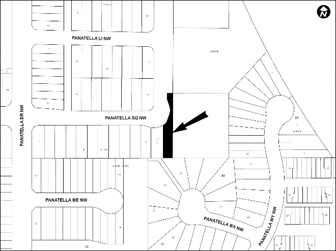
PLAN 2410260, AREA ‘A’
LOC2023-0107
LAND USE REDESIGNATION
BYLAW 124D2024
To redesignate the land located adjacent to 67 Panatella Square NW (Plan 2410260, Area ‘A’) from Undesignated Road Right-of-Way to Multi-Residential – Low Profile (M-1d85) District.
SAGE HILL
LOC2023-0151
LAND USE REDESIGNATION
BYLAW 144D2024
To redesignate the land located at 13616 – 30 Street NW (Plan 8011537, Block 1) from Special Purpose – Future Urban Development (S-FUD) District to Residential – Low Density Mixed Housing (R-G) District, Multi-Residential – At Grade Housing (M-G) District and Special Purpose – Urban Nature (S-UN) District.
WEST HILLHURST
LOC2023-0384
LAND USE REDESIGNATION
BYLAW 122D2024
To redesignate the land located at 2511 – 3 Avenue NW (Plan 331AB, Block 1, Lots 5 and 6) from Residential – Contextual One / Two Dwelling (R-C2) District to Residential – Grade-Oriented Infill (R-CG) District.
LOC2023-0342
LAND USE REDESIGNATION
BYLAW 139D2024
To redesignate the land located at 114 and 118 – 19 Street NW (Plan 8942GB, Block 19, Lots 11 and 12) from Residential – Contextual One / Two Dwelling (R-C2) District to Mixed Use – General (MU-1f1.5h12) District.
LOC2023-0386
LAND USE REDESIGNATION
BYLAW 147D2024
To redesignate the land located at 2624 – 1 Avenue NW (Plan 330AB, Block 5, Lots 10 and 11) from Residential – Contextual One / Two Dwelling (R-C2) District to Multi-Residential – Contextual Grade-Oriented (M-CGd80) District.
NE
RENFREW
LOC2023-0398
LAND USE REDESIGNATION
BYLAW 131D2024
To redesignate the land located at 525, 527 and 529 – 12 Avenue NE (Plan 2310226, Block 46, Lots 41 to 43) from Residential – Contextual One / Two Dwelling (R-C2) District to Housing – Grade Oriented (H-GO) District.
WINSTON HEIGHTS/MOUNTVIEW
LOC2023-0399
LAND USE REDESIGNATION
BYLAW 126D2024
To redesignate the land located at 632 – 26 Avenue NE (Plan 770JK, Block 6A, Lot 16) from Residential – Contextual One / Two Dwelling (R-C2) District to Residential – Grade-Oriented Infill (R-CG) District.
SW
ALPINE PARK
LOC2023-0380
LAND USE REDESIGNATION
BYLAW 152D2024
To redesignate the land located at 15153 – 37 Street SW (Portion of NE1/4 Section 36-22-2-5) from Direct Control (DC) District, Multi-Residential – High Density Low Rise (M-H1) District and Residential – Low Density Mixed Housing (R-G) District to Residential – Low Density Mixed Housing (R-G) District and Direct Control (DC) District.
BANKVIEW
LOC2023-0350
LAND USE REDESIGNATION
BYLAW 120D2024
To redesignate the land located at 2131 and 2135 – 16A Street SW (Plan 261L, Block 9, Lots 15 to 18) from Residential – Contextual One / Two Dwelling (R-C2) District to Housing – Grade Oriented (H-GO) District.
LOC2023-0350
AMENDMENT TO THE BANKVIEW AREA REDEVELOPMENT PLAN
BYLAW 23P2024
The proposed amendment to the Bankview Redevelopment Plan (ARP) would change the land use policy for the site located at 2131 – 16A Street SW and 2135 – 16A Street SW from ‘Conservation’ to ‘Medium Density’. This proposed policy amendment is conjunction with the proposed land use redesignation for the site (Bylaw 120D2024). For further information, please contact 403-816-2735.
KILLARNEY/GLENGARRY
LOC2023-0363
LAND USE REDESIGNATION
BYLAW 119D2024
To redesignate the land located at 3438 – 37 Street SW (Plan 732GN, Block 3, Lot 17) from Residential – Contextual One / Two Dwelling (R-C2) District to Housing – Grade Oriented (H-GO) District.
LOC2023-0395
LAND USE REDESIGNATION
BYLAW 138D2024
To redesignate the land located at 3308 – 26 Avenue SW, 2632 and 2636 – 33 Street SW (Plan 1855W, Block 4B, Lots 36 to 40) from Residential – Contextual One / Two Dwelling (R-C2) District to Housing – Grade-Oriented (H-GO) District.
KINGSLAND
LOC2023-0333
LAND USE REDESIGNATION
BYLAW 134D2024
To redesignate the land located at 813 – 67 Avenue SW (Plan 4910AK, Block 9, Lots 13 and 14) from Residential – Contextual One / Two Dwelling (R-C2) District to Housing – Grade Oriented (H-GO) District.
MANCHESTER
LOC2023-0364
LAND USE REDESIGNATION
BYLAW 151D2024
To redesignate the land located at 5440 – 1 Street SW (Plan 5531HQ, Parcel D) from Industrial – General (I-G) District to Industrial – Business f1.0 (I-Bf1.0) District.
SPRINGBANK HILL
LOC2023-0310
LAND USE REDESIGNATION
BYLAW 127D2024
To redesignate the land located at 217 Springbluff Boulevard SW and 7545 Elkton Drive SW (Plan 252HP, Block 4; Plan 2370IB, Block 3, Lot 3) from Residential – One Dwelling (R-1) District and Direct Control (DC) District to Residential – One Dwelling (R-1s) District.
SUNALTA
LOC2023-0334
LAND USE REDESIGNATION
BYLAW 148D2024
To redesignate the land located at 1707, 1709, 1711, 1713 and 1717 – 12 Avenue SW (Plan 5380V, Block 218, Lots 11 to 17) from Multi-Residential – Contextual Grade-Oriented (M-CGd111) District to Multi-Residential – Contextual Medium Profile (M-C2f1.5) District.
LOC2023-0334
AMENDMENT TO THE SUNALTA AREA REDEVELOPMENT PLAN
BYLAW 32P2024
The proposed amendment to the Sunalta Area Redevelopment Plan would change the land use policy for the site located at 1707, 1709, 1711, 1713 and 1717 – 12 Avenue SW from Medium Low Density to Medium Density. This proposed policy amendment is in conjunction with the proposed land use redesignation for the site (Bylaw 148D2024). For further information, please contact 587-576-4314.
SE
ALBERTA PARK/RADISSON HEIGHTS
LOC2023-0209
LAND USE REDESIGNATION
BYLAW 145D2024
To redesignate the land located at 1103 – 36 Street SE (Plan 5498T, Block 8, Lots 21 and 22) from Residential – Contextual One / Two Dwelling (R-C2) District to Multi-Residential – Contextual Low Profile (M-C1) District.
LOC2023-0209
AMENDMENT TO THE ALBERTA PARK/RADISSON HEIGHTS AREA REDEVELOPMENT PLAN
BYLAW 30P2024
The proposed amendment to the Albert Park/Radisson Heights Area Redevelopment Plan would change the land use policy for the site located at 1103 – 36 Street SE from ‘Low Density Residential’ to ‘Medium Density Residential’. This proposed policy amendment is in conjunction with the proposed land use redesignation for the site (Bylaw 145D2024). For further information, please contact 587-215-4174.
BURNS INDUSTRIAL
LOC2023-0230
LAND USE REDESIGNATION
BYLAW 153D2024
To redesignate the land located at 820 – 59 Avenue SE (Plan 8311705, Block 4, Lot 2) from Industrial – General (I-G) District to Industrial – Business f1.0h18 (I-Bf1.0h18) District.
DOUGLASDALE/GLEN
LOC2023-0168
LAND USE REDESIGNATION
BYLAW 149D2024
To redesignate the land located at 10605 – 24 Street SE and 10610 – 18 Street SE (Plan 1510561, Block 5, Lot 10; Plan 1410076, Block 5, Lot 8) from Industrial – Business f1.0h24 (IBf1.0h24) District to Multi-Residential – High Density Low Rise (M-H1) District, Multi-Residential – Medium Profile (M-2) District and Mixed Use – General (MU1f3.0h50) District.
LOC2023-0168
AMENDMENTS TO THE BARLOW AREA STRUCTURE PLAN
BYLAW 33P2024
Policy amendments to the Barlow Area Structure Plan (ASP) are proposed in conjunction with the Land Use Amendment and Outline Plan for the Neighbourhood of Douglasdale/Glen. The amendments involve updates to the Industrial Land Use policies, as well as other map and technical amendments to allow residential development in the ASP. This proposed policy amendment is in conjunction with the proposed land use redesignation for the site (Bylaw 149D2024). For further information, please contact 403-816-2735.
FAIRVIEW INDUSTRIAL
LOC2023-0293
LAND USE REDESIGNATION
BYLAW 154D2024
To redesignate the land located at 7810 Macleod Trail SE (Plan 3176HO, Block 6, Lot 6) from Commercial – Corridor 3 f1.0h12 (C-COR3f1.0h12) District to Direct Control (DC) District to accommodate a Self Storage Facility.
LOC2019-0082
ROAD CLOSURE
BYLAW 4C2024 AND BYLAW 5C2024
The City of Calgary intends pursuant to s.22 of the Municipal Government Act to consider bylaws to close from use and sell or hold those portions of the streets, roads, lanes or public highways described here.
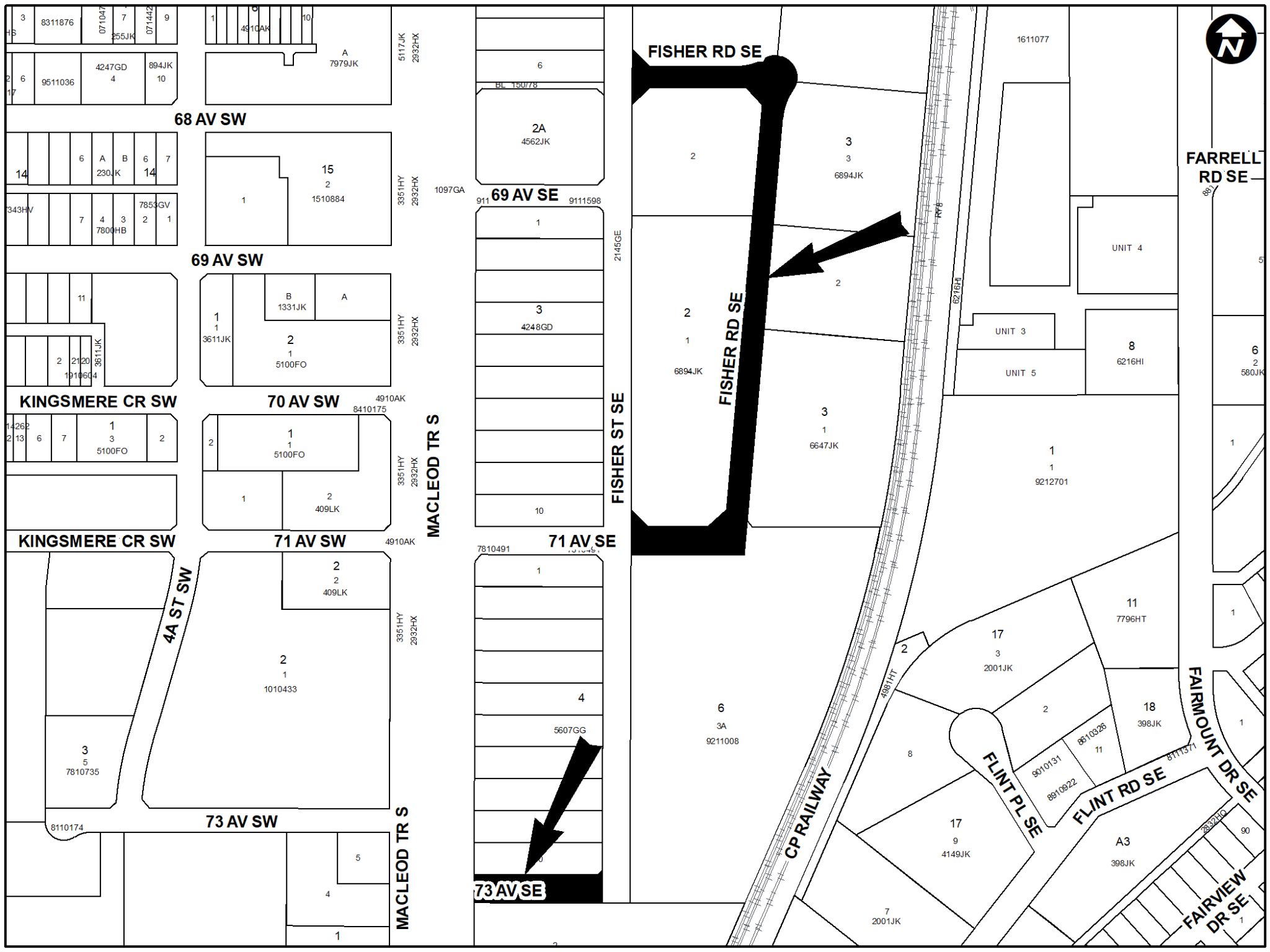
PLAN 2410555 AND PLAN 2410556
LOC2019-0082
LAND USE REDESIGNATION
BYLAW 155D2024
To redesignate the land located at 7330 Macleod Trail SE, 6712, 6940, 7012, 7110, 7130, 7132, and 7220 Fisher Street SE, 130 – 71 Avenue SE, 7203 Flint Place SE and the closed roads (Plan 5607GG, Block 4, Lots 7 to 10; Plan 1435LK, Lot 1; Plan 6894JK, Block 2, Lot 1; Plan 9211008, Block 6, Lot 3A; Plan 6894JK, Block 2; Lot 1; Plan 6894JK, Block 3, Lots 2 to 4; Plan 6647JK, Block 3, Lot 1; Plan 4149JK, Block 17, Lot 8; Plan 2410555; Plan 2410556) from Commercial – Corridor 3 f1.0h12 (C-COR3 f1.0h12) District, Industrial – General (I-G) District and Undesignated Road Right-of Way to Special Purpose – School, Park and Community Reserve (S-SPR) District and Direct Control (DC) District to accommodate mixed use developments.
LOC2019-0082
AMENDMENTS TO THE MUNICIPAL DEVELOPMENT PLAN (BYLAW 34P2024), AND
HERITAGE COMMUNITIES LOCAL AREA PLAN (BYLAW 35P2024)
The proposed amendments to the Municipal Development Plan (MDP) and MDP Volume 3: (Calgary Transportation Plan), and the Heritage Communities Local Area Plan are to accommodate high-density mixed-use developments known as ‘Midtown’ for the parcels located at 7330 Macleod Trail SE, 6712, 6940, 7012, 7110, 7130, 7132, and 7220 Fisher Street SE, 130 – 71 Avenue SE, and 7203 Flint Place SE. The amendments would identify Midtown as a Community Activity Centre and would provide planning policies to guide the redevelopment of these sites. These proposed policy amendments are in conjunction with the proposed land use redesignation (Bylaw 155D2024) and proposed road closures (Bylaws 4C2024 and 5C2024). For further information, please contact 403-200-8575.
FOREST LAWN
LOC2023-0401
LAND USE REDESIGNATION
BYLAW 118D2024
To redesignate the land located at 1306 – 36 Street SE (Plan 2700AH, Block 24, Lots 17 and 18) from Residential – Contextual One / Two Dwelling (R-C2) District to Housing – Grade Oriented (H-GO) District.
LOC2023-0401
AMENDMENT TO THE FOREST LAWN-FOREST HEIGHTS/HUBALTA AREA REDEVELOPMENT PLAN
BYLAW 22P2024
The proposed amendment to the Forest Lawn-Forest Heights/Hubalta Area Redevelopment Plan would change the land use policy for the site located at 1306 – 36 Street SE from ‘Low Density Residential/Conservation’ to ‘Low Density Multi-Dwelling’. This proposed policy amendment is in conjunction with the proposed land use redesignation for the site (Bylaw 118D2024). For further information, please contact 403-815-4326.
LOC2023-0337
LAND USE REDESIGNATION
BYLAW 141D2024
To redesignate the land located at 1339 – 40 Street SE (Plan 5111HH, Block 21, Lot 6) from Residential – Grade-Oriented Infill (R-CG) District to Housing – Grade Oriented (H-GO) District.
LOC2023-0337
AMENDMENT TO THE FOREST LAWN-FOREST HEIGHTS/HUBALTA AREA REDEVELOPMENT PLAN
BYLAW 27P2024
The proposed amendment to the Forest Lawn-Forest Heights/Hubalta Area Redevelopment Plan would change the land use policy for the site located at 1339 – 40 Street SE from ‘Neighbourhood Limited’ to ‘Neighbourhood Low Rise’. The proposed policy amendment is in conjunction with the proposed land use redesignation for the site (Bylaw 141D2024). For further information, please contact 368-995-2048.
LOC2023-0339
LAND USE REDESIGNATION
BYLAW 142D2024
To redesignate the land located at 1536 – 37 Street SE (Plan 6906HJ, Block 10, Lot 2) from Residential – Grade-Oriented Infill (R-CG) District to Housing – Grade Oriented (H-GO) District.
LOC2023-0339
AMENDMENT TO THE FOREST LAWN-FOREST HEIGHTS/HUBALTA AREA REDEVELOPMENT PLAN
BYLAW 28P2024
The proposed amendment to the Forest Lawn-Forest Heights/Hubalta Area Redevelopment Plan would change the land use policy for the site located at 1536 – 37 Street SE from ‘Neighbourhood Limited’ to ‘Neighbourhood Low Rise’. This proposed policy amendment is in conjunction with the proposed land use redesignation for the site (Bylaw 142D2024). The amendments are being proposed in order to allow for this site to be developed into a courtyard oriented stacked townhouse development with five dwelling units and five secondary suites. For further information, please contact 403-519-9055.
LOC2023-0338
LAND USE REDESIGNATION
BYLAW 146D2024
To redesignate the land located at 1511 – 37 Street SE (Plan 5428GG, Block 9, Lot 4) from Residential – Grade-Oriented Infill (R-CG) District to Housing – Grade Oriented (H-GO) District.
LOC2023-0338
AMENDMENT TO THE FOREST LAWN-FOREST HEIGHTS/HUBALTA AREA REDEVELOPMENT PLAN
BYLAW 31P2024
The proposed amendment to the Forest Lawn-Forest Heights/Hubalta Area Redevelopment Plan would change the land use policy for the site located at 1511 – 37 Street SE from ‘Neighbourhood Limited’ to ‘Neighbourhood Low Rise’. This proposed policy amendment is in conjunction with the proposed land use redesignation for the site (Bylaw 146D2024). For further information, please contact 403-808-6189.
MAHOGANY
LOC2023-0321
LAND USE REDESIGNATION
BYLAW 135D2024
To redesignate the land located at 213 and 215 Magnolia Terrace SE (Plan 2211011, Block 120, Lots 7 and 8) from Residential – Low Density Mixed Housing (R-G) District to Direct Control (DC) District to accommodate a Child Care Service.
OGDEN
LOC2024-0010
LAND USE REDESIGNATION
BYLAW 137D2024
To redesignate the land located at 7615 – 25 Street SE (Plan 375AM, Block 10, Lots 7 and 8) from Residential – Contextual One / Two Dwelling (R-C2) District to Residential – Grade-Oriented Infill (R-CG) District.
LOC2024-0010
AMENDMENTS TO THE MILLICAN-OGDEN AREA REDEVELOPMENT PLAN
BYLAW 25P2024
The proposed amendments to the Millican-Ogden Area Redevelopment Plan would change the land use policy for the site located at 7615 – 25 Street SE from ‘Low Density Conservation’ to ‘Low or Medium Density Multi-Dwelling Residential’, in addition to modifying Policy 2 of Section 3.4.3.3 to increase the allowable density at the subject site. These proposed policy amendments are in conjunction with the proposed land use redesignation for the site (Bylaw 137D2024). For further information, please contact 587-572-2076.
April 22 public hearing
CITYWIDE
AMENDMENTS TO THE LAND USE BYLAW (1P2007)
BYLAW 21P2024
This bylaw proposes amendments to Land Use Bylaw (LUB) 1P2007 to redesignate (rezone) portions of the City of Calgary to allow for a greater range of low-density housing forms. This change will allow for rowhouses and townhouses in all low-density residential parcels across the City of Calgary in addition to the building types already allowed (e.g., single-detached dwellings, semi detached dwellings, duplexes, and suites). The amendments include:
- Implement a singular base residential district. Rezoning for R-C1, R-C1(s), R-C1L, R-C1L(s), R-C1N, R-C2, R-CGex to R-CG and R-1, R-1(s), R-1N, R-2 to R-G.
- Where identified as suitable rezone to the H-GO District in the following three approved Local Area Plans: North Hill Communities, Westbrook Communities and Heritage Communities
- Allow for both a secondary suite and backyard suite on one parcel and eliminate the parking requirements for backyard suites. Delete all redundant sections of the Land Use Bylaw:
- R-C1(s)
- R-C1L(s)
- R-C1N
- R-C2
- R-CGex
- R-1
- R-1(s)
- R-1N
- R-2
- Other housekeeping amendments
These amendments will reduce barriers for the development of housing, provide a greater range of choice for Calgarians and demonstrate a significant step forward in delivering on Calgarians’ housing needs through Home is Here – The City of Calgary’s Housing Strategy 2024-2030. For further information please contact the Planning Service Centre 403-268-5311 or visit Rezoning for housing (calgary.ca). The rezoning will come into effect on August 6, 2024 and the removal of redundant districts will take place on December 31, 2024.
April 9 public hearing
BANFF TRAIL
LOC2023-0331
LAND USE REDESIGNATION
BYLAW 98D2024
To redesignate the land located at 3432 Cascade Road NW (Plan 2846GW, Block 4, Lot 20) from Residential – Grade-Oriented Infill (R-CG) District to Housing – Grade Oriented (H-GO) District.
LOC2023-0331
AMENDMENT TO THE BANFF TRAIL AREA REDEVELOPMENT PLAN
BYLAW 15P2024
This proposal is to amend the Banff Trail Area Redevelopment Plan to allow for a multi-residential development at 3432 Cascade Road NW. The amendments will revise Map 2 to identify the parcel as ‘Medium Density Low-Rise’, and apply the applicable Design Guidelines, and Map 3 to identify the parcel as ‘12 m’. This proposed policy amendment is in conjunction with the proposed land use redesignation for the site (Bylaw 98D2024). For further information, please contact 587-576-3079.
LOC2023-0287
LAND USE REDESIGNATION
BYLAW 110D2024
To redesignate the land located at 2221 – 23 Avenue NW (Plan 9110GI, Block 13, Lot 16) from Residential – Grade-Oriented Infill (R-CG) District to Direct Control (DC) District to accommodate rowhouse development.
BOWNESS
LOC2023-0238
LAND USE REDESIGNATION
BYLAW 93D2024
To redesignate the land located at 8532 – 46 Avenue NW (Plan 2660AP, Block 10, Lot 20) from Residential – Contextual One / Two Dwelling (R-C2) District to Residential – Grade-Oriented Infill (R-CG) District.
LOC2023-0361
LAND USE REDESIGNATION
BYLAW 102D2024
To redesignate the land located at 8916 – 33 Avenue NW (Plan 3023GJ, Block 21, Lot 13) from Residential – Contextual One Dwelling (R-C1) District to Residential – Grade-Oriented Infill (R-CG) District.
LOC2022-0218
LAND USE REDESIGNATION
BYLAW 105D2024
To redesignate the land located at 8304 – 46 Avenue NW (Plan 2660AP, Block 9, Lot 13) from Residential – Contextual One / Two Dwelling (R-C2) District to Residential – Grade-Oriented Infill (R-CG) District.
LOC2022-0206
LAND USE REDESIGNATION
BYLAW 109D2024
To redesignate the land located at 8148 – 46 Avenue NW (Plan 2660AP, Block 8, Lot 24) from Residential – Contextual One / Two Dwelling (R-C2) District to Residential – Grade-Oriented Infill (R-CG) District.
CAPITOL HILL
LOC2023-0235
LAND USE REDESIGNATION
BYLAW 89D2024
To redesignate the land located at 1732 – 22 Avenue NW (Plan 2864AF, Block 23, Lots 15 and 16) from Residential – Contextual One / Two Dwelling (R-C2) District to Residential – Grade-Oriented Infill (R-CG) District.
CARRINGTON
LOC2022-0078
LAND USE REDESIGNATION
BYLAW 94D2024
To redesignate the land located at 13717R Centre Street NW (portion of NE1/4 Section 33-25-1-5) from Residential – Narrow Parcel One Dwelling (R-1N) District, Residential – One / Two Dwelling (R-2) District and Residential – Low Density Multiple Dwelling (R-2M) District to Residential – Low Density Mixed Housing (R-G) District and Residential – Low Density Mixed Housing (R-Gm) District.
HOUNSFIELD HEIGHTS-BRIAR HILL
LOC2023-0318
LAND USE REDESIGNATION
BYLAW 90D2024
To redesignate the land located at 1239 – 18A Street NW (Plan 5625AC, Block 15, Lot 17) from Residential – Contextual One Dwelling (R-C1) District to Residential – Grade-Oriented Infill (R-CG) District.
LOC2023-0318
AMENDMENT TO THE HOUNSFIELD HEIGHTS-BRIAR HILL AREA REDEVELOPMENT PLAN
BYLAW 11P2024
The proposed amendment to the Hounsfield Heights/Briar Hill Area Redevelopment Plan would change the land use policy for the site located at 1239 – 18A Street NW to note that the Residential – Contextual Grade-Oriented (R-CG) District is considered appropriate to this site as part of the Low Density Residential, Conservation and Infill Policy. The other change is to exempt the site from the restrictions on subdivision and development in the Area Redevelopment Plan. This proposed policy amendment is in conjunction with the proposed land use redesignation for the site (Bylaw 90D2024). For further information, please contact 587-223-2498.
LOC2023-0366
LAND USE REDESIGNATION
BYLAW 103D2024
To redesignate the land located at 2304 Juniper Road NW (Plan 4683GP, Block 23, Lot 18) from Residential – Contextual One Dwelling (R-C1) District to Residential – Contextual One / Two Dwelling (R-C2) District.
LOC2023-0366
AMENDMENT TO THE HOUNSFIELD HEIGHTS-BRIAR HILL AREA REDEVELOPMENT PLAN
BYLAW 13P2024
The proposed amendment to the Hounsfield Heights/Briar Hill Area Redevelopment Plan would change the land use policy for the site located at 2304 Juniper Road NW to exempt the site from the restrictions on subdivision and development in the Area Redevelopment Plan. This proposed policy amendment is in conjunction with the proposed land use redesignation for the site (Bylaw 103D2024). For further information, please contact 825-945-8759.
MONTGOMERY
LOC2023-0274
LAND USE REDESIGNATION
BYLAW 91D2024
To redesignate the land located at 1804 – 51 Street NW (Plan 67GN, Block 2, Lot 24) from Residential – Contextual One Dwelling (R-C1) District to Residential – Grade-Oriented Infill (R-CG) District.
LOC2023-0274
AMENDMENT TO THE MONTGOMERY AREA REDEVELOPMENT PLAN
BYLAW 12P2024
The proposed amendment to the Montgomery Area Redevelopment Plan would change the land use policy for the site located at 1804 – 51 Street NW from Low Density Residential to Low Density Residential/Townhouse in order to allow for this site to be developed with grade-oriented infill housing which may include single-detached, semi-detached, duplex homes, townhouses or rowhouses with up to four dwelling units. This proposed policy amendment is in conjunction with the proposed land use redesignation for the site (Bylaw 91D2024). For further information, please contact 368-997-4044.
MOUNT PLEASANT
LOC2023-0381
LAND USE REDESIGNATION
BYLAW 101D2024
To redesignate the land located at 839 – 22 Avenue NW (Plan 2934O, Block 27, Lots 21 and 22) from Residential – Contextual One / Two Dwelling (R-C2) District to Residential – Grade-Oriented Infill (R-CG) District.
RESIDUAL SUB-AREA 1B
LOC2023-0345
LAND USE REDESIGNATION
BYLAW 96D2024
To redesignate the land located at 9852 and 10010 Bearspaw Dam Road NW (Plan 0011353, Block 2; Plan 288LK, Parcels B and C) from Special Purpose – Transportation and Utility Corridor (S-TUC) District to Special Purpose – City and Regional Infrastructure (S-CRI) District.
BRIDGELAND-RIVERSIDE
LOC2023-0408
LAND USE REDESIGNATION
BYLAW 116D2024
To redesignate the land located at 10 – 11A Street NE (Plan 766JK, Lot 2) from Special Purpose – Community Institution (S-CI) District to Mixed Use – General (MU1f4.5h40) District, Mixed Use – General (MU-1f4.5h55) District, Mixed Use – General (MU-1f4.5h86) District, and Special Purpose – Community Service (S-CS) District.
LOC2023-0408
AMENDMENTS TO THE BRIDGELAND-RIVERSIDE AREA REDEVELOPMENT PLAN
BYLAW 20P2024
The proposed amendments to the Bridgeland-Riverside Area Redevelopment Plan would change the land use policy for the site located at 10 – 11A Street NE from Institutional to Urban Neighbourhood, and provide design guidelines for consideration for future development on the site. This proposed policy amendment is in conjunction with the proposed land use redesignation for the site (Bylaw 116D2024). For further information, please contact 587-576-3085.
CRESCENT HEIGHTS
LOC2023-0289
LAND USE REDESIGNATION
BYLAW 95D2024
To redesignate the land located at 339, 341 and 347 – 3 Avenue NE (Plan 1332N, Block 6, Lots 49 to 52 and a portion of Lot 48) from Multi-Residential – Contextual Grade-Oriented (M-CGd72) District to Multi-Residential – Contextual Low Profile (M-C1) District.
HIGHLAND PARK
LOC2023-0352
LAND USE REDESIGNATION
BYLAW 100D2024
To redesignate the land located at 212 – 32 Avenue NE (Plan 5942AD, Block 4, Lots 14 to 16) from Residential – Contextual One / Two Dwelling (R-C2) District to Residential – Grade-Oriented Infill (R-CG) District.
RENFREW
LOC2023-0286
LAND USE REDESIGNATION
BYLAW 61D2024
To redesignate the land located at 602 – 13 Avenue NE (Plan 791P, Block 56, Lots 19 and 20) from Residential – Contextual One / Two Dwelling (R-C2) District to Residential – Grade-Oriented Infill (R-CG) District.
TUXEDO PARK
LOC2023-0134
LAND USE REDESIGNATION
BYLAW 97D2024
To redesignate the land located at 201 and 203 – 17 Avenue NE (Plan 4804N, Block A, Lots 31 and 32) from Multi-Residential – Medium Profile Support Commercial (M-X2) District to Multi-Residential – Contextual Medium Profile (M-C2) District.
BANKVIEW
LOC2023-0311
LAND USE REDESIGNATION
BYLAW 111D2024
To redesignate the land located at 1501, 1505, 1507, 1509, 1511, 1513 and 1515 – 25 Avenue SW (Plan 3910R, Block 2, Lots 2 to 6 and 23 to 25) from Residential – Contextual One / Two Dwelling (R-C2) District to Direct Control (DC) District to accommodate retention of existing historic houses and allow for opportunities for additional development.
ERLTON
LOC2023-0415
LAND USE REDESIGNATION
BYLAW 115D2024
To redesignate the land located at 24, 26 and 38 – 28 Avenue SW (Plan 2865AC, Block 2, Lots 29 to 40) from Multi-Residential – Contextual Grade-Oriented (M-CGd72) District and Special Purpose – Community Service (S-CS) District to Multi-Residential – Contextual Medium Profile (M-C2) District.
LOC2023-0415
AMENDMENT TO THE ERLTON AREA REDEVELOPMENT PLAN
BYLAW 19P2024
The proposed amendments to the Erlton Area Redevelopment Plan would change the land use policy for the site located at 24, 26 and 38 – 28 Avenue SW from ‘Erlton School’ to ‘Medium to High Density Residential’. An amendment to the Land Use Recommendations Table (Site 4) is required to support the associated land use amendment for the site (Bylaw 115D2024). For further information, please contact 403-312-2846.
GLENBROOK
LOC2023-0351
LAND USE REDESIGNATION
BYLAW 106D2024
To redesignate the land located at 3916 – 30 Avenue SW (Plan 1365AH, Block 31, Lots 51 and 52) from Residential – Contextual One / Two Dwelling (R-C2) District to Residential – Grade-Oriented Infill (R-CG) District.
KILLARNEY/GLENGARRY
LOC2023-0362
LAND USE REDESIGNATION
BYLAW 104D2024
To redesignate the land located at 2037 – 28 Street SW (Plan 5661O, Block 9, Lots 19, 20 and a portion of Lot 18) from Direct Control (DC) District to Residential – Grade-Oriented Infill (R-CG) District.
LOC2022-0061
LAND USE REDESIGNATION
BYLAW 107D2024
To redesignate the land located at 2240 – 26 Street SW (Plan 5561O, Block 20, Lots 21 and 22) from Residential – Contextual One / Two Dwelling (R-C2) District to Residential – Grade-Oriented Infill (R-CG) District.
KINGSLAND
LOC2023-0247
LAND USE REDESIGNATION
BYLAW 83D2024
To redesignate the land located at 8224 Elbow Drive SW (Plan 5375HH, Block 8, Lot 39) from Residential – Contextual One Dwelling (R-C1) District to Housing – Grade Oriented (H-GO) District.
SPRINGBANK HILL
LOC2022-0215
LAND USE REDESIGNATION
BYLAW 117D2024
To redesignate the land located at 2026 – 81 Street SW from Direct Control (DC) District to Mixed Use – General (MU-1f5.0h35) District, Multi-Residential – High Density Low Rise (M-H1h25) District and Special Purpose – School, Park and Community Reserve (S-SPR) District.
SUNALTA
LOC2023-0308
LAND USE REDESIGNATION
BYLAW 113D2024
To redesignate the land located at 1540 and 1602 – 10 Avenue SW (Plan 5380V, Block 208, Lots 22 and 23) from Direct Control (DC) District to Direct Control (DC) District to accommodate a mixed-use development with a relaxation clause.
WEST SPRINGS
LOC2023-0254
LAND USE REDESIGNATION
BYLAW 112D2024
To redesignate the land located at 850 and 870 – 81 Street SW (Plan 9811875, Block 42, Lot 1; Plan 4740AK, Block 42) from Direct Control (DC) District to Residential – One Dwelling (R-1s) District, Multi-Residential – At Grade Housing (M-G) District, and Special Purpose – School, Park and Community Reserve (S-SPR) District.
ALBERT PARK/RADISSON HEIGHTS
LOC2023-0275
LAND USE REDESIGNATION
BYLAW 114D2024
To redesignate the land located at 3345 – 12 Avenue SE (Plan 2870JK, Block 4, Lot B), 3416 – 16 Avenue SE (Plan 2870JK, Block 4, Lot B) and 1511 – 34 Street SE (Plan 4649GL, Lot B) from Special Purpose – School, Park and Community Reserve (S-SPR) District and Residential – Contextual One Dwelling (R-C1) District to Special Purpose – School, Park and Community Reserve (S-SPR) District and Direct Control (DC) District to accommodate grade-oriented residential development.
LOC2023-0275
AMENDMENTS TO THE ALBERT PARK/ RADISSON HEIGHTS AREA REDEVELOPMENT PLAN
BYLAW 18P2024
The proposed amendments to the Albert Park/Radisson Heights Area Redevelopment Plan would change the land use policy for the parcels located at 3345 – 12 Avenue SE and 3416 – 16 Avenue SE and 1511 – 34 Street SE from Open Space, Park, School or Community Facility and School to Open Space, Park, School or Community Facility and Medium Density Residential. Amendment to the ARP also include updating information on the former David D. Oughton school site, as the site is no longer a school site. This proposed policy amendment is in conjunction with the proposed land use redesignation for the site (Bylaw 114D2024). For further information please contact the file manager at 403-808-9141.
EAST SHEPARD INDUSTRIAL
LOC2023-0335
LAND USE REDESIGNATION
BYLAW 99D2024
To redesignate the land located at #300, 5126 – 126 Avenue SE (Plan 2211713, Block 9, Lot 8) from Industrial – General (I-G) District to Industrial – Commercial (I-C) District.
OGDEN
LOC2023-0305
LAND USE REDESIGNATION
BYLAW 108D2024
To redesignate the land located at 7425 – 20 Street SE (Plan 955AV, Block 8, Lots 12 and 13) from Residential – Contextual One / Two Dwelling (R-C2) District to Residential – Grade-Oriented Infill (R-CG) District.
LOC2023-0305
AMENDMENTS TO THE MILLICAN-OGDEN AREA REDEVELOPMENT PLAN
BYLAW 14P2024
The proposed amendments would change the land use policy for the site located at 7425 – 20 Street SE from Low Density Conservation to Low or Medium Density Multi-Dwelling Residential. To allow for the density allocated through proposed land use district, a text amended is also required. This proposed policy amendments are in conjunction with the proposed land use redesignation for the site (Bylaw 108D2024). For further information, please contact 587-582-2128.
SOUTHVIEW
LOC2023-0306
LAND USE REDESIGNATION
BYLAW 92D2024
To redesignate the land located at 2029 – 28 Street SE (Plan 3244GR, Block 16, Lot 21) from Residential – Contextual One Dwelling (R-C1) District to Residential – Contextual One / Two Dwelling (R-C2) District.
AMENDMENTS TO THE BELTLINE AREA REDEVELOPMENT PLAN
BYLAW 16P2024
This policy amendment is to amend several chapters of the Beltline Area Redevelopment Plan (ARP) to align with the Municipal Development Plan, Greater Downtown Plan and Part 2 of the Beltline ARP, approved by Council in 2019. Proposed amendments include climate change mitigation and adaption policies, a three- or more-bedroom unit incentive policy, the addition of a contribution of cash-in-lieu of Affordable Housing and a revised Beltline History (including stories from the Indigenous and LGBTQ2+ communities). Also included is a new Parks and Public Realm chapter supported by a non-statutory Beltline Parks and Public Realm Playbook. For further information, please contact 403-808-0556.
AMENDMENTS TO THE LAND USE BYLAW (1P2007)
BYLAW 17P2024
This bylaw amendment is to facilitate implementation of the proposed amendments to Chapters 4, 5 and 7 of the Beltline Area Redevelopment Plan. The Centre City Districts are located in Part 11 of Land Use Bylaw 1P2007. The proposed amendments affect the four Centre City Districts and the Rules Governing Centre City Bonus Overlays, Division 7. The proposed land use amendments align the Land Use Bylaw with the proposed Beltline ARP density and related bonusing provisions. For further information, please contact 403-808-0556.
January 16 public hearing
BOWNESS
LOC2023-0231
LAND USE REDESIGNATION
BYLAW 12D2024
To redesignate the land located at 7903 – 36 Avenue NW (Plan 5960AM, Block 9, Lot 10) from Residential – Contextual One Dwelling (R-C1) District to Residential – Grade-Oriented Infill (R-CG) District.
HIGHLAND PARK
LOC2023-0201
LAND USE REDESIGNATION
BYLAW 4D2024
To redesignate the land located at 4216 – 2 Street NW (Plan 6482GN, Block 8, Lot 2) from Residential – Contextual One / Two Dwelling (R-C2) District to Residential – Grade-Oriented Infill (R-CG) District.
MOUNT PLEASANT
LOC2023-0099
LAND USE REDESIGNATION
BYLAW 21D2024
To redesignate the land located at 836 and 912 – 16 Avenue NW (Plan 1213510, Block 4, Lot 41; Plan 1513006, Block 5, Lot 27) from Commercial – Corridor 1 f5.0h32 (C-COR1f5.0h32) District to Mixed Use – Active Frontage (MU-2f7.0h44) District.
BRIDGELAND/RIVERSIDE
LOC2023-0264
AMENDMENT TO THE BRIDGELAND-RIVERSIDE AREA REDEVELOPMENT PLAN
BYLAW 3P2024
The proposed amendment to the Bridgeland-Riverside Area Redevelopment Plan (ARP) is intended to exempt the subject site from the ARP requirement of a higher parking rate than that of the Land Use Bylaw. This will allow the Land Use Bylaw to determine the parking for the site, ensuring consistency with how parking is determined in other areas of the city. For further information, please contact 587-215-2052.
RESIDUAL SUB-AREA 5D
LOC2023-0113
LAND USE REDESIGNATION
BYLAW 22D2024
To redesignate the land located at 14010 – 52 Street NE (Portion of Plan 0211280, Block 1, Lot 1) from Special Purpose – Future Urban Development (S-FUD) District to Direct Control (DC) District to accommodate a waste storage site.
WINSTON HEIGHTS/MOUNTVIEW
LOC2023-0154
LAND USE REDESIGNATION
BYLAW 5D2024
To redesignate the land located at 532 – 34 Avenue NE (Plan 5942AD, Block 10, Lots 1 and 2) from Residential – Contextual One / Two Dwelling (R-C2) District to Residential – Grade-Oriented Infill (R-CG) District.
LOC2023-0265
LAND USE REDESIGNATION
BYLAW 13D2024
To redesignate the land located at 820 – 17 Avenue NE (Plan 4930GV, Block 6, Lot 35) from Residential – Contextual One / Two Dwelling (R-C2) District to Residential – Grade-Oriented Infill (R-CG) District.
ALTADORE
LOC2023-0096
LAND USE REDESIGNATION
BYLAW 2D2024
To redesignate the land located at 3721 – 14A Street SW (Plan 1965P, Block B, Lots 11 to 13) from Residential – Contextual One / Two Dwelling (R-C2) District to Residential – Grade-Oriented Infill (R-CG) District.
LOC2023-0096
AMENDMENT TO THE SOUTH CALGARY/ALTADORE AREA REDEVELOPMENT PLAN
BYLAW 1P2024
The proposed amendment to the South Calgary/Altadore Area Redevelopment Plan would change the land use policy for the site located at 3721 – 14A Street SW from ‘Residential Conservation’ to ‘Residential Low Density’. This proposed policy amendment is in conjunction with the proposed land use redesignation for the site (Bylaw 2D2024). For further information, please contact 403-312-2846.
GLAMORGAN
LOC2023-0226
LAND USE REDESIGNATION
BYLAW 10D2024
To redesignate the land located at 91 Gloucester Crescent SW (Plan 567HH, Block 6, Lot 10) from Residential – Contextual One Dwelling (R-C1) District to Residential – Contextual One / Two Dwelling (R-C2) District.
GLENBROOK
LOC2023-0233
LAND USE REDESIGNATION
BYLAW 15D2024
To redesignate the land located at 3119 – 45 Street SW (Plan 5709HL, Block 41, Lot 16) from Residential – Contextual One Dwelling (R-C1) District to Housing – Grade Oriented (H-GO) District.
KILLARNEY/GLENGARRY
LOC2023-0216
LAND USE REDESIGNATION
BYLAW 3D2024
To redesignate the land located at 3033 – 27 Street SW (Plan 5561O, Block 52, Lots 16 and 17) from Direct Control (DC) District to Residential – Contextual One / Two Dwelling (R-C2) District.
LOC2023-0223
LAND USE REDESIGNATION
BYLAW 6D2024
To redesignate the land located at 3436 Richmond Road SW (Plan 732GN, Block 1, Lot 9) from Direct Control (DC) District to Housing – Grade Oriented (H-GO) District.
LOC2023-0157
LAND USE REDESIGNATION
BYLAW 14D2024
To redesignate the land located at 2228 and 2236 – 29 Street SW (Plan 5661O, Block 24, Lots 23 to 28) from Multi-Residential – Contextual Grade-Oriented (M-CGd111) District and Commercial – Neighbourhood 1 (C-N1) District to Mixed Use – General (MU-1f1.5h16) District.
LOWER MOUNT ROYAL
LOC2023-0232
LAND USE REDESIGNATION
BYLAW 9D2024
To redesignate the land located at 1723 – 9 Street SW (Plan 179R, Block 29, Lot 9) from Multi-Residential – Contextual Medium Profile (M-C2) District to Direct Control (DC) District to accommodate a wellness and arts centre.
MANCHESTER INDUSTRIAL
LOC2022-0210
LAND USE REDESIGNATION
BYLAW 16D2024
To redesignate the land located at 210 – 61 Avenue SW and 6110, 6120 and 6130 – 1A Street SW (Plan 8811604, Lots 3 to 5; Plan 7995HD, Parcel 1) from Direct Control (DC) District to Direct Control (DC) District to accommodate mixed use development.
NORTH GLENMORE PARK
LOC2023-0126
LAND USE REDESIGNATION
BYLAW 1D2024
To redesignate the land located at 2139 – 51 Avenue SW (Plan 7280AJ, Block 18, Lots 1 and 2) from Residential – Contextual One / Two Dwelling (R-C2) District to Residential — Grade-Oriented Infill (R-CG) District.
SHAGANAPPI
LOC2023-0208
LAND USE REDESIGNATION
BYLAW 7D2024
To redesignate the land located at 1711 – 26 Street SW (Plan 960GB, Block E, Lot 3) from Residential – Contextual One / Two Dwelling (R-C2) District to Housing – Grade Oriented (H-GO) District.
LOC2023-0071
LAND USE REDESIGNATION
BYLAW 18D2024
To redesignate the land located at 1750 and 1750Q – 29 Street SW and 2940 – 17 Avenue SW (Plan 2312030, Block 1, Lots 7 and 8; Plan 1712166, Block 1, Lot 6) from Direct Control (DC) District to Direct Control (DC) District to accommodate a small format digital sign.
SOUTH CALGARY
LOC2023-0224
LAND USE REDESIGNATION
BYLAW 11D2024
To redesignate the land located at 1931 – 26 Avenue SW (Plan 4479P, Block 5, Lots 25 and 26) from Residential – Contextual One / Two Dwelling (R-C2) District to Residential – Grade-Oriented Infill (R-CG) District.
LOC2023-0224
AMENDMENT TO THE BANKVIEW AREA REDEVELOPMENT PLAN
BYLAW 2P2024
The proposed amendment to the Bankview Area Redevelopment Plan would change the land use policy for the site located at 1931 – 26 Avenue SW from Conservation to Conservation and Infill. This proposed policy amendment is in conjunction with the proposed land use redesignation for the site (Bylaw 11D2024). For further information, please contact 403 312-2557.
EAST SHEPARD INDUSTRIAL
LOC2023-0191
LAND USE REDESIGNATION
BYLAW 17D2024
To redesignate the land located at 11211 and 11235 – 52 Street SE (Portion of SE 1/4 Section 15-23-29-4) from Special Purpose – Future Urban Development (S-FUD) District to Industrial – General (I-G) District.
GREAT PLAINS EAST
LOC2023-0158
LAND USE REDESIGNATION
BYLAW 8D2024
To redesignate the land located at 7919 – 84 Street SE (Plan 7549JK, a portion of Block 1) from Industrial – Outdoor (I-O) District to Industrial – General (I-G) District.
HIGHFIELD
LOC2023-0220
LAND USE REDESIGNATION
BYLAW 19D2024
To redesignate the land located at 1010 – 42 Avenue SE (Plan 2310194, Block 1, Lot 1) from Direct Control (DC) District and Industrial – General (I-G) District to Direct Control (DC) District to accommodate the discretionary use of Gaming Establishment – Casino.
IP2023-1264
OFF-SITE LEVIES CHARTER BYLAW
BYLAW 1H2024
The proposed Off-site Levies Bylaw 1H2024 is a Charter Bylaw that will impose off-site levies to pay for the capital cost of the infrastructure forming the subject of the off site levies, land required for or in connection with the infrastructure, and the interest cost of borrowing to finance the capital costs of the infrastructure and land. Pursuant to s. 648 of the Municipal Government Act and s. 4 of the City of Calgary Charter, 2018 Regulation. For further information, please contact 403-268-5311.
December 5 public hearing
BANFF TRAIL
LOC2023-0182
LAND USE REDESIGNATION
BYLAW 248D2023
To redesignate the land located at 2015 – 26 Avenue NW (Plan 8543GN, Block 7, Lot 16) from Residential – Contextual One / Two Dwelling (R-C2) District to Residential – Grade-Oriented Infill (R-CG) District.
LOC2023-0182
AMENDMENT TO THE BANFF TRAIL AREA REDEVELOPMENT PLAN
BYLAW 86P2023
The proposed amendments to the Banff Trail Area Redevelopment Plan would change the land use policy for the site located at 2015 – 26 Avenue NW from Low Density Residential to Low Density Rowhouse. This proposed policy amendment is in conjunction with the proposed land use redesignation for the site (Bylaw 248D2023). For further information, please contact 403-815-4326.
BOWNESS
LOC2023-0170
LAND USE REDESIGNATION
BYLAW 242D2023
To redesignate the land located at 8304 – 47 Avenue NW (Plan 2660AP, Block 2, Lot 13) from Residential – Contextual One Dwelling (R-C1) District to Residential – Grade-Oriented Infill (R-CG) District.
CAPITOL HILL
LOC2023-0204
LAND USE REDESIGNATION
BYLAW 234D2023
To redesignate the land located at 1212 – 20 Avenue NW (Plan 3150P, Block 23, Lots 5 and 6) from Residential – Grade-Oriented Infill (R-CG) District to Housing – Grade Oriented (H-GO) District.
CRESCENT HEIGHTS
LOC2023-0056
LAND USE REDESIGNATION
BYLAW 241D2023
To redesignate the land located at 1402 – 4 Street NW (Plan 3946N, Block 1, Lots 34 and 35) from Residential – Contextual One / Two Dwelling (R-C2) District to Residential – Grade-Oriented Infill (R-CG) District.
HIGHLAND PARK
LOC2023-0054
LAND USE REDESIGNATION
BYLAW 257D2023
To redesignate the land located at 204, 208, 212, 216, 220 and 224 – 40 Avenue NW (Plan 5422GK, Block 3, Lots 11 to 16) from Residential – Grade-Oriented Infill (R-CG) and Residential – Contextual One / Two Dwelling (R-C2) District to Housing – Grade Oriented (H-GO) District.
LOC2023-0184
LAND USE REDESIGNATION
BYLAW 258D2023
To redesignate the land located at 4023 Centre B Street NW (Plan 3674S, Block 26, Lots 22 and 23) from Residential – Contextual One / Two Dwelling (R-C2) District to Housing – Grade Oriented (H-GO) District.
MONTGOMERY
LOC2023-0200
LAND USE REDESIGNATION
BYLAW 243D2023
To redesignate the land located at 5015 – 22 Avenue NW (Plan 4994GI, Block 50, Lot 17) from Residential – Contextual One Dwelling (R-C1) District to Residential – Contextual One / Two Dwelling (R-C2) District.
LOC2023-0200
AMENDMENT TO THE MONTGOMERY AREA REDEVELOPMENT PLAN
BYLAW 85P2023
The proposed amendments to the Montgomery Area Redevelopment Plan would change the land use policy for the site located at 5015 – 22 Avenue NW to allow for infill development. This proposed policy amendment is in conjunction with the proposed land use redesignation for the site (Bylaw 243D2023). For further information, please contact 587-215-4174.
LOC2023-0213
LAND USE REDESIGNATION
BYLAW 249D2023
To redesignate the land located at 4767 Montana Crescent NW (Plan 485GR, Block 5, Lot 17) from Residential – Contextual One Dwelling (R-C1) District to Residential – Grade-Oriented Infill (R-CG) District.
LOC2023-0213
AMENDMENT TO THE MONTGOMERY AREA REDEVELOPMENT PLAN
BYLAW 87P2023
The proposed amendment to the Montgomery Area Redevelopment Plan would change the land use policy for the site located at 4767 Montana Crescent NW from Low Density Residential to Low Density Residential/Townhouse in order to allow for this site to be developed with grade-oriented infill housing which may include single-detached, semi-detached, duplex homes, townhouses or rowhouses with up to 5 dwelling units. This proposed policy amendment is in conjunction with the proposed land use redesignation for the site (Bylaw 249D2023). For further information, please contact 368-997-4044.
MOUNT PLEASANT
LOC2023-0187
LAND USE REDESIGNATION
BYLAW 246D2023
To redesignate the land located at 901 – 20 Avenue NW (Plan 2934O, Block 16, Lots 25 and 26) from Residential – Contextual One / Two Dwelling (R-C2) District to Residential – Grade-Oriented Infill (R-CG) District.
TUXEDO PARK
LOC2017-0149
LAND USE REDESIGNATION
BYLAW 245D2023
To redesignate the land located at 202 – 23 Avenue NW (Plan 2129O, Block 33, Lots 1 and 2) from Residential – Contextual One / Two Dwelling (R-C2) District to Residential – Grade-Oriented Infill (R-CG) District.
VARSITY
LOC2023-0228
LAND USE REDESIGNATION
BYLAW 247D2023
To redesignate the land located at 612R Varsity Estates Place NW (Plan 2011543, Block 20, Lot 25) from Special Purpose – Recreation (S-R) District to Residential – Contextual One Dwelling (R-C1) District.
WEST HILLHURST
LOC2023-0159
LAND USE REDESIGNATION
BYLAW 235D2023
To redesignate the land located at 110 – 18A Street NW (Plan 1612424, Block 14, Lot 37) from Direct Control (DC) District to Direct Control (DC) District to accommodate a liquor store.
SOUTH AIRWAYS
LOC2023-0192
LAND USE REDESIGNATION
BYLAW 256D2023
To redesignate the land located at 2222 – 16 Avenue NE (Plan 8210122, Block 9, Lot 1) from Direct Control (DC) District to Direct Control (DC) District to accommodate additional commercial uses.
TUXEDO PARK
LOC2023-0067
LAND USE REDESIGNATION
BYLAW 259D2023
To redesignate the land located at 328 – 29 Avenue NE (Plan 2617AG, Block 49, Lots 37 and 38) from Residential – Contextual One / Two Dwelling (R-C2) District to Multi-Residential – Contextual Low Profile (M-C1) District.
WINSTON HEIGHTS/MOUNTVIEW
LOC2023-0202
LAND USE REDESIGNATION
BYLAW 232D2023
To redesignate the land located at 501 – 21 Avenue NE (Plan 3182FU, Block 5, Lot 15) from Residential – Contextual One / Two Dwelling (R-C2) District to Residential – Grade-Oriented Infill (R-CG) District.
ALTADORE
LOC2023-0149
LAND USE REDESIGNATION
BYLAW 252D2023
To redesignate the land located at 1920 – 36 Avenue SW and 3504 and 3512 – 19 Street SW (Plan 3890AG, Block B, Lots 15 to 28) from Mixed Use – Active Frontage (MU-2f3.0h16) District to Mixed Use – Active Frontage (MU-2f4.0h23) District and Mixed Use – General (MU-1f3.5h23) District.
LOC2023-0149
AMENDMENT TO THE MARDA LOOP AREA REDEVELOPMENT PLAN
BYLAW 88P2023
The proposed amendment to the Marda Loop Area Redevelopment would change the maximum building height for the site located at 1920 – 36 Avenue SW and 3504, 3512 – 19 Street SW from 4 Storeys in 16 metres to 6 Storeys in 23 metres. This proposed policy amendment is in conjunction with the proposed land use redesignation for the site (Bylaw 252D2023. For further information, please contact 403-268-5344.
LOC2023-0206
LAND USE REDESIGNATION
BYLAW 254D2023
To redesignate the land located at 2039 – 34 Avenue SW (Plan 4530AC, Block 3, Lots 19 to 20) from Multi-Residential – Contextual Low Profile (M-C1) District to Mixed Use – General (MU1f3.0h16) District.
LOC2023-0206
AMENDMENT TO THE SOUTH CALGARY/ALTADORE AREA REDEVELOPMENT PLAN
BYLAW 89P2023
The proposed amendment to the South Calgary/Altadore Area Redevelopment Plan would change the land use policy for the site located at 2039 – 34 Avenue SW from Residential Medium Density to Community Mid-Rise. This proposed policy amendment is in conjunction with the proposed land use redesignation for the site (Bylaw 254D2023). For further information, please contact 403-305-0297.
BRIDLEWOOD
LOC2023-0195
LAND USE REDESIGNATION
BYLAW 231D2023
To redesignate the land located at 102 Bridleridge Way SW (Plan 0210776, Lot 5, Block 64) from Direct Control (DC) District to Residential – Narrow Parcel One Dwelling (R-1N) District.
BRITANNIA
LOC2022-0224
ROAD CLOSURE
BYLAW 10C2023
The City of Calgary intends pursuant to s.22 of the Municipal Government Act to consider bylaws to close from use and sell or hold those portions of the streets, roads, lanes or public highways described here.
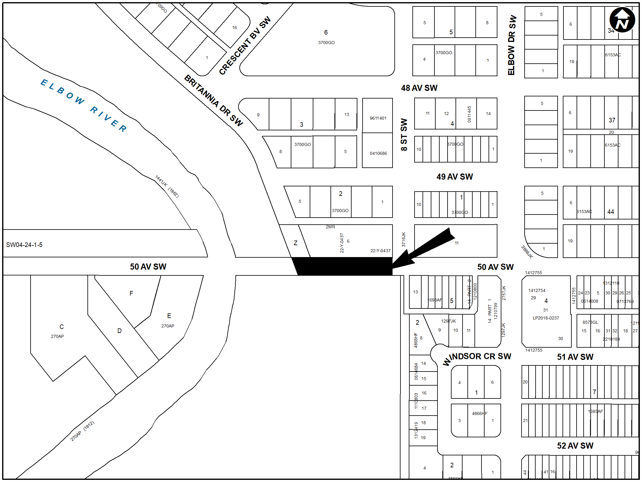
PLAN 2311119, AREA ‘A’
LOC2022-0224
LAND USE REDESIGNATION
BYLAW 237D2023
To redesignate the land located at 914 – 50 Avenue SW and the closed road (Plan 1710667, Area B; Plan 2311119, Area ‘A’) from Residential – Contextual One Dwelling (R-C1) District and Undesignated Road Right-of-Way to Special Purpose – School, Park and Community Reserve (S-SPR) District and Special Purpose – Recreation (S-R) District.
GLAMORGAN
LOC2023-0180
LAND USE REDESIGNATION
BYLAW 240D2023
To redesignate the land located at 4160 – 42 Street SW (Plan 567HH, Block 1, Lot 8) from Residential – Contextual One / Two Dwelling (R-C2) District to Residential – Grade-Oriented Infill (R-CG) District.
GLENDALE
LOC2023-0152
LAND USE REDESIGNATION
BYLAW 233D2023
To redesignate the land located at 1903 Grand Oaks Drive SW (Plan 1402JK, Block 1, Lot 2) from Residential – Contextual One Dwelling (R-C1) District to Mixed Use – General (MU-1f1.7h11) District.
LOC2023-0081
LAND USE REDESIGNATION
BYLAW 251D2023
To redesignate the land located at 1904 Georgia Street SW (Plan 774HI, Block 1, Lots 1 to 3) from Residential – Contextual One Dwelling (R-C1) District to Mixed Use – General (MU1f4.0h22) District.
KILLARNEY/GLENGARRY
LOC2023-0221
LAND USE REDESIGNATION
BYLAW 238D2023
To redesignate the land located at 2439 – 32 Street SW (Plan 1855W, Block 5B, Lots 1 and 2) from Residential – Contextual One / Two Dwelling (R-C2) District to Residential – Grade-Oriented Infill (R-CG) District.
LOC2023-0169
LAND USE REDESIGNATION
BYLAW 255D2023
To redesignate the land located at 2639 – 29 Street SW (Plan 1855W, Block 1B, Lots 1 and 2) from Commercial – Neighbourhood 1 (C-N1) District to Housing – Grade Oriented (H-GO) District.
RUTLAND PARK
LOC2023-0225
LAND USE REDESIGNATION
BYLAW 239D2023
To redesignate the land located at 3439 – 33 Street SW (Plan 199GM, Block 14, Lot 7) from Residential – Contextual One Dwelling (R-C1) District to Residential – Grade-Oriented Infill (R-CG) District.
SPRUCE CLIFF
LOC2023-0147
LAND USE REDESIGNATION
BYLAW 253D2023
To redesignate the land located at 3508 – 8 Avenue SW (Plan 2566GQ, Block 16, Lot 15) from Residential – Contextual One / Two Dwelling (R-C2) District to Housing – Grade Oriented (H-GO) District.
WINDSOR PARK
LOC2022-0224
ROAD CLOSURE
BYLAW 10C2023
The City of Calgary intends pursuant to s.22 of the Municipal Government Act to consider bylaws to close from use and sell or hold those portions of the streets, roads, lanes or public highways described here.
PLAN 2311119, AREA ‘A’
LOC2022-0224
LAND USE REDESIGNATION
BYLAW 237D2023
To redesignate the land located at 914 – 50 Avenue SW and the closed road (Plan 1710667, Area B; Plan 2311119, Area ‘A’) from Residential – Contextual One Dwelling (R-C1) District and Undesignated Road Right-of-Way to Special Purpose – School, Park and Community Reserve (S-SPR) District and Special Purpose – Recreation (S-R) District.
ALBERT PARK/RADISSON HEIGHTS
LOC2023-0160
LAND USE REDESIGNATION
BYLAW 244D2023
To redesignate the land located at 2831 – 15 Avenue SE (Plan 4946T, Block 18, Lots 15 and 16) from Residential – Contextual One / Two Dwelling (R-C2) District to Residential – Grade-Oriented Infill (R-CG) District.
FOREST LAWN
LOC2023-0148
LAND USE REDESIGNATION
BYLAW 250D2023
To redesignate the land located at 2620 – 40 Street SE (Plan 1301HK, Block T, Lot 11) from Residential – Contextual One Dwelling (R-C1) District to Direct Control (DC) District to accommodate the additional discretionary use of Community Recreation Facility.
HORIZON
LOC2023-0153
LAND USE REDESIGNATION
BYLAW 236D2023
To redesignate the land located at #1000, #3000, #4000 and #5000, 2600 – 48 Avenue NE (Condominium Plan 2210879, Units 1 to 4; Condominium Plan 2210879, Common Property) from Direct Control (DC) District to Direct Control (DC) District to allow for the additional use of Place of Worship – Small.
October 3 public hearing
BANFF TRAIL
LOC2023-0117
LAND USE REDESIGNATION
BYLAW 182D2023
To redesignate the land located at 2804 Capitol Hill Crescent NW (Plan 2846GW, Block 4, Lot 1) from Residential – Contextual One / Two Dwelling (R-C2) District to Housing – Grade Oriented (H-GO) District.
BOWNESS
LOC2023-0115
LAND USE REDESIGNATION
BYLAW 163D2023
To redesignate the land located at 8816 – 46 Avenue NW (Plan 4960AP, Block 5, Lot 14) from Residential – Contextual One Dwelling (R-C1) District to Residential – Contextual One / Two Dwelling (R-C2) District.
LOC2023-0093
LAND USE REDESIGNATION
BYLAW 164D2023
To redesignate the land located at 8816 and 8932 – 34 Avenue NW (Plan 5960AM, Block 2, Lot 14; Plan 3023GJ, Block 1, Lot 16) from Residential – Contextual One Dwelling (R-C1) District and Residential – Contextual One Dwelling (R-C1s) District to Residential – Contextual One / Two Dwelling (R-C2) District.
CAPITOL HILL
LOC2023-0032
LAND USE REDESIGNATION
BYLAW 175D2023
To redesignate the land located at 1539 – 22 Avenue NW (Plan 2864AF, Block 6, Lots 21 and 22) from Residential – Contextual One / Two Dwelling (R-C2) District to Residential – Grade-Oriented Infill (R-CG) District.
MONTGOMERY
LOC2023-0058
LAND USE REDESIGNATION
BYLAW 167D2023
To redesignate the land located at 5011 – 21 Avenue NW (Plan 3898AF, Block 37, Lot 20) from Residential – Contextual One Dwelling (R-C1) District to Residential – Contextual One / Two Dwelling (R-C2) District.
LOC2023-0058
AMENDMENT TO THE MONTGOMERY AREA REDEVELOPMENT PLAN
BYLAW 67P2023
The proposed amendments to the Montgomery Area Redevelopment Plan would change the land use policy for the site located at 5011 – 21 Avenue NW to allow for infill development. This proposed policy amendment is in conjunction with the proposed land use redesignation for the site (Bylaw 167D2023). For further information, please contact 368-997-4044.
LOC2023-0129
LAND USE REDESIGNATION
BYLAW 173D2023
To redesignate the land located at 4911 – 19 Avenue NW (Plan 5439FW, Block 21, Lot 11) from Residential – Contextual One Dwelling (R-C1) District to Residential – Contextual One / Two Dwelling (R-C2) District.
LOC2023-0129
AMENDMENT TO THE MONTGOMERY AREA REDEVELOPMENT PLAN
BYLAW 69P2023
The proposed amendments to the Montgomery Area Redevelopment Plan would change the land use policy for the site located at 4911 – 19 Avenue NW to allow for infill development. This proposed policy amendment is in conjunction with the proposed land use redesignation for the site (Bylaw 173D2023). For further information, please contact 587-215-4174.
MOUNT PLEASANT
LOC2023-0050
LAND USE REDESIGNATION
BYLAW 170D2023
To redesignate the land located at 501 and 505 – 30 Avenue NW (Plan 3955R, Block 16, Lots 37 to 40) from Direct Control (DC) District to Housing – Grade Oriented (H-GO) District.
LOC2023-0146
LAND USE REDESIGNATION
BYLAW 172D2023
To redesignate the land located at 902 – 21 Avenue NW (Plan 2934O, Block 26, Lots 1 and 2) from Residential – Contextual One / Two Dwelling (R-C2) District to Residential – Grade-Oriented Infill (R-CG) District.
RENFREW
LOC2023-0143
LAND USE REDESIGNATION
BYLAW 171D2023
To redesignate the land located at 602 – 8 Avenue NE (Plan 470P, Block 51, Lots 19 and 20) from Residential – Contextual One / Two Dwelling (R-C2) District to Housing – Grade-Oriented (H-GO) District.
LOC2023-0145
LAND USE REDESIGNATION
BYLAW 174D2023
To redesignate the land located at 539 – 10 Avenue NE (Plan 470P, Block 44, Lot 40 and a portion of Lot 39) from Residential – Contextual One / Two Dwelling (R-C2) District to Residential – Grade-Oriented Infill (R-CG) District.
TUXEDO PARK
LOC2023-0119
LAND USE REDESIGNATION
BYLAW 181D2023
To redesignate the land located at 252 – 19 Avenue NE (Plan 1367O, Block 2, Lot 26 and a portion of Lot 27) from Residential – Contextual One / Two Dwelling (R-C2) District to Multi-Residential – Contextual Grade-Oriented (M-CGd85) District.
ALTADORE
LOC2023-0138
LAND USE REDESIGNATION
BYLAW 178D2023
To redesignate the land located at 3719 – 14A Street SW (Plan 1965P, Block B, Lots 9 and 10) from Residential – Contextual One / Two Dwelling (R-C2) District to Residential – Grade-Oriented Infill (R-CG) District.
LOC2023-0138
AMENDMENT TO THE SOUTH CALGARY/ALTADORE AREA REDEVELOPMENT PLAN
BYLAW 70P2023
The proposed amendment to the South Calgary/Altadore Area Redevelopment Plan would change the land use policy for the site located at 3719 – 14A Street SW from Residential Conservation to Residential Low Density. This proposed policy amendment is in conjunction with the proposed land use redesignation for the site (Bylaw 178D2023). For further information, please contact 403-312-2846.
CLIFF BUNGALOW
LOC2023-0128
LAND USE REDESIGNATION
BYLAW 150D2023
To redesignate the land located at 534 – 23 Avenue SW (Plan 4453L, Block 6, a portion of Lot 20) from Multi-Residential – Contextual Grade-Oriented (M-CGd111) District to Direct Control (DC) District to accommodate Health Care Service.
GLENDALE
LOC2022-0117
LAND USE REDESIGNATION
BYLAW 189D2023
To redesignate the land located at 4919, 4923, 4927, 4931 and 4935 – 17 Avenue SW (Plan 6182HM, Block 5, Lots 43 to 47) from Multi-Residential – Contextual Low Profile (M-C1) District to Housing – Grade Oriented (H-GO) District.
LOC2023-0062
LAND USE REDESIGNATION
BYLAW 190D2023
To redesignate the land located at 1904 Glenwood Drive SW (Plan 1365GT, Block 8, Lot 10) from Residential – Contextual One Dwelling (R-C1) District to Housing – Grade Oriented (H-GO) District.
KILLARNEY/GLENGARRY
LOC2022-0209
LAND USE REDESIGNATION
BYLAW 149D2023
To redesignate the land located at 2604, 2608, 2612, 2616, 2620, 2628, 2632, 2636 and 2640 – 37 Street SW (Plan 4367X, Block 10E, Lots 21 to 30 and 33 to 40) from Mixed Use – General (MU-1f3.0h16) District to Mixed Use – Active Frontage (MU-2f4.0h26) District.
LOC2023-0084
LAND USE REDESIGNATION
BYLAW 177D2023
To redesignate the land located at 2639 – 28 Street SW (Plan 5661O, Block 40, Lots 19 and 20) from Residential – Contextual One / Two Dwelling (R-C2) District to Residential – Grade-Oriented Infill (R-CG) District.
LOC2023-0042
LAND USE REDESIGNATION
BYLAW 186D2023
To redesignate the land located at 3206 – 29 Street SW (Plan 5661O, Block 53, Lots 37 and 38) from Direct Control (DC) District to Housing – Grade Oriented (H-GO) District.
LOC2023-0044
LAND USE REDESIGNATION
BYLAW 187D2023
To redesignate the land located at 3207 – 29 Street SW (Plan 5435AV, Block 3C, Lots 3 and 4) from Direct Control (DC) District to Housing – Grade Oriented (H-GO) District.
LOWER MOUNT ROYAL
LOC2022-0104
LAND USE REDESIGNATION
BYLAW 188D2023
To redesignate the land located at 1815 – 8 Street SW (Plan 4453L, Block 14, a portion of Lot 11) from Multi-Residential – Contextual Medium Profile (M-C2) District to Direct Control (DC) District to accommodate a Tattoo Studio.
LOC2022-0104
AMENDMENT TO THE LOWER MOUNT ROYAL AREA REDEVELOPMENT PLAN
BYLAW 73P2023
The proposed amendment to the Lower Mount Royal Area Redevelopment Plan would introduce limited non-residential land use policies within the Low Rise, Medium Density Residential area. The proposed amendments apply specifically to the site located at 1815 – 8 Street SW and are in conjunction with the proposed land use redesignation for this parcel (Bylaw 188D2023). The amendments are being proposed to accommodate expansion of a tattoo studio within an existing single detached dwelling. For further information, please contact 403-268-1426.
RICHMOND
LOC2023-0142
LAND USE REDESIGNATION
BYLAW 179D2023
To redesignate the land located at 2645 – 21 Street SW and 2208 – 26 Avenue SW (Plan 8997GC, Block 7, Lots 1 and 2) from Residential – Contextual One / Two Dwelling (R-C2) District to Residential – Grade-Oriented Infill (R-CG) District.
LOC2023-0142
AMENDMENT TO THE RICHMOND AREA REDEVELOPMENT PLAN
BYLAW 71P2023
The proposed amendment to the Richmond Area Redevelopment Plan would redesignate the site located at 2645 – 21 Street SW and 2208 – 26 Avenue SW from Conservation/Infill to Low Density Residential. This proposed policy amendment is in conjunction with the proposed land use redesignation for the site (Bylaw 179D2023). For further information, please contact 587-572-7491.
LOC2023-0061
LAND USE REDESIGNATION
BYLAW 183D2023
To redesignate the land located at 2012 – 26 Avenue SW (Plan 8997GC, Block 17, Lot 15) from Residential – Contextual One / Two Dwelling (R-C2) District to Direct Control (DC) District to accommodate a Child Care Service.
SOUTH CALGARY
LOC2023-0098
LAND USE REDESIGNATION
BYLAW 169D2023
To redesignate the land located at 1512 – 29 Avenue SW (Plan 4479P, Block 27, Lots 5 and 6) from Multi-Residential – Contextual Low Profile (M-C1d75) District to Commercial – Corridor 1 f1.0h12 (C-COR1f1.0h12) District.
LOC2023-0098
AMENDMENT TO THE SOUTH CALGARY/ALTADORE AREA REDEVELOPMENT PLAN
BYLAW 68P2023
The proposed amendment to the South Calgary/Altadore Area Redevelopment Plan would change the land use policy for the site located at 1512 – 29 Avenue SW from ‘Residential Low Density’ to ‘General Commercial’. This proposed policy amendment is in conjunction with the proposed land use redesignation for the site (Bylaw 169D2023). For further information, please contact 403-669-8595.
LOC2023-0023
LAND USE REDESIGNATION
BYLAW 180D2023
To redesignate the land located at 2008 – 28 Avenue SW (Plan 4479P, Block 15, Lot 4, a portion of Lot 3 and a portion of Lot 5) from Residential – One / Two Dwelling (R-C2) District to Residential – Grade-Oriented Infill (R-CG) District.
LOC2023-0023
AMENDMENT TO THE SOUTH CALGARY ALTADORE AREA REDEVELOPMENT PLAN
BYLAW 72P2023
The proposed amendment to the South Calgary/Altadore Area Redevelopment Plan would change the land use policy for the site located at 2008 – 28 Avenue SW from ‘Residential Conservation’ to ‘Residential Low Density’. This proposed policy amendment is in conjunction with the proposed land use redesignation for the site (Bylaw 180D2023). For further information, please contact 587-576-4310.
WEST SPRINGS
LOC2022-0231
LAND USE REDESIGNATION
BYLAW 191D2023
To redesignate the land located at 781 – 77 Street SW (Portion of Plan 4740AK, Block 49) from Special Purpose – School, Park and Community Reserve (S-SPR) District and Direct Control (DC) District to Special Purpose – School, Park and Community Reserve (S-SPR) District and Direct Control (DC) District to accommodate a neighbourhood commercial hub.
LOC2022-0231
AMENDMENT TO THE WEST SPRINGS AREA STRUCTURE PLAN
BYLAW 74P2023
The proposed amendments to the West Springs Area Structure Plan would change the land use policy for the site located at 781 – 77 Street SW to adjust the shape of the parcel. Maps 3, 4 and 5 are affected by this amendment. The overall vision for the area is not anticipated to change. These proposed policy amendments are in conjunction with the proposed land use redesignation for the site (Bylaw 191D2023). For further information, please contact 587-216-8073.
ACADIA
LOC2022-0226
LAND USE REDESIGNATION
BYLAW 185D2023
To redesignate the land located at 8390 and 8500 Macleod Trail SE (Plan 8311110, Lot B; Plan 1233LK, Block B, Lot 4) from Commercial – Corridor 3 f1.54h19 (C-COR3f1.54h19) District to Commercial – Corridor 1 f2.0h19 (C-COR1f2.0h19) District.
ALBERT PARK/RADISSON HEIGHTS
LOC2023-0135
LAND USE REDESIGNATION
BYLAW 176D2023
To redesignate the land located at 2822 and 2828 – 11 Avenue SE (Plan 4946T, Block 9, Lots 27 to 32) from Residential – Contextual One / Two Dwelling (R-C2) District to Residential – Grade-Oriented Infill (R-CG) District.
INGLEWOOD
LOC2021-0197
LAND USE REDESIGNATION
BYLAW 165D2023
To redesignate the land located at 2231 – 16 Street SE (Plan 1894AC, Block 18, Lots 24 and 25) from Residential – Contextual One / Two Dwelling (R-C2) District to Residential – Grade-Oriented Infill (R-CG) District.
LOC2023-0002
LAND USE REDESIGNATION
BYLAW 168D2023
To redesignate the land located at 1301 – 10 Avenue SE (Plan A3, Block 5, Lots 37 and 38) from Residential – Contextual One / Two Dwelling (R-C2) District to Mixed Use – General (MU-1f2.0h14) District.
OGDEN
LOC2023-0065
LAND USE REDESIGNATION
BYLAW 166D2023
To redesignate the land located at 1928 – 62 Avenue SE (Plan 2515AM, Block 2, Lots 27 and 28) from Residential – Contextual One / Two Dwelling (R-C2) District to Residential – Grade-Oriented Infill (R-CG) District.
LOC2023-0065
AMENDMENT TO THE MILLICAN-OGDEN AREA REDEVELOPMENT PLAN
BYLAW 66P2023
The proposed amendments to the Millican-Ogden Area Redevelopment Plan would change the land use policy for the site located at 1928 – 62 Avenue SE from ‘Low Density Conservation’ to ‘Low or Medium Density Multi-Dwelling Residential’ as well as a text amendment to recognize the density allotted through the R-CG District for this specific site. This proposed policy and text amendments are in conjunction with the proposed land use redesignation for the site (Bylaw 166D2023). For further information, please contact 587-215-2730.
WALDEN
LOC2023-0017
LAND USE REDESIGNATION
BYLAW 184D2023
To redesignate the land located at 969 Walden Drive SE (Plan 1912127, Block 12, Lot 52) from Special Purpose – City and Regional Infrastructure (S-CRI) District to Special Purpose – Community Service (S-CS) District.
September 19 public hearing
BOWNESS
LOC2023-0018
LAND USE REDESIGNATION
BYLAW 144D2023
To redesignate the land located at 7936 and 7938 – 33 Avenue NW (Plan 5960AM, Block 12, Lot 19) from Residential – Contextual One Dwelling (R-C1) District to Residential – Contextual One / Two Dwelling (R-C2) District.
LOC2023-0052
LAND USE REDESIGNATION
BYLAW 145D2023
To redesignate the land located at 8619 – 47 Avenue NW (Plan 4960AP, Block 4, Lot 6) from Residential – Contextual One Dwelling (R-C1) District to Residential – Contextual One / Two Dwelling (R-C2) District.
CAPITOL HILL
LOC2023-0039
LAND USE REDESIGNATION
BYLAW 128D2023
To redesignate the land located at 1512 – 21 Avenue NW (Plan 2864AF, Block 6, Lots 5 and 6) from Residential – Contextual One / Two Dwelling (R-C2) District to Residential – Grade-Oriented Infill (R-CG) District.
LOC2023-0022
LAND USE REDESIGNATION
BYLAW 130D2023
To redesignate the land located at 1740 – 22 Avenue NW (Plan 2864AF, Block 23, Lots 19 and 20) from Residential – Contextual One / Two Dwelling (R-C2) District to Residential – Grade-Oriented Infill (R-CG) District.
LOC2023-0109
LAND USE REDESIGNATION
BYLAW 147D2023
To redesignate the land located at 1740 – 19 Avenue NW (Plan 2864AF, Block 20, Lots 19 and 20) from Residential – Contextual One / Two Dwelling (R-C2) District to Residential – Grade-Oriented Infill (R-CG) District.
LOC2023-0035
LAND USE REDESIGNATION
BYLAW 158D2023
To redesignate the land located at 1836 – 17 Avenue NW (Plan 2864AF, Block 31, Lots 17 and 18) from Residential – Contextual One / Two Dwelling (R-C2) District to Multi-Residential – Contextual Grade-Oriented (M-CG) District.
CHARLESWOOD
LOC2022-0098
LAND USE REDESIGNATION
BYLAW 156D2023
To redesignate the land located at 3502 Charleswood Drive NW (Plan 8172HS, Block 3, Lot 45) from Residential – Contextual One Dwelling (R-C1) District to Housing – Grade Oriented (H-GO) District.
CRESCENT HEIGHTS
LOC2023-0036
LAND USE REDESIGNATION
BYLAW 131D2023
To redesignate the land located at 202 – 11 Avenue NW (Plan 3946N, Block 13, Lots 21 and 22) from Residential – Contextual One / Two Dwelling (R-C2) District to Residential – Grade-Oriented Infill (R-CG) District.
GLACIER RIDGE
LOC2022-0165
LAND USE REDESIGNATION
BYLAW 162D2023
To redesignate the land located at 6500 – 144 Avenue NW (portions of NW1/4, SW1/4, SE1/4 Section 2-26-2-5) and 15505 Symons Valley Road NW (portions of NE1/4 Section 2-26-2-5) from Residential – Low Density Mixed Housing (R-G) District, Multi-Residential – Low Profile (M-1) District, Multi-Residential – Low Profile Support Commercial (M-X1) District, Special Purpose – School, Park and Community Reserve (S-SPR) District, Special Purpose – City and Regional Infrastructure (S-CRI) District and Special Purpose – Urban Nature (S-UN) District to Residential – Low Density Mixed Housing (R-G) District, Mixed Use – General (MU-1h20) District, Special Purpose – School, Park and Community Reserve (S-SPR) District, Special Purpose – Recreation (S-R) District, Special Purpose – City and Regional Infrastructure (S-CRI) District, and Special Purpose – Urban Nature (S-UN) District.
HIGHLAND PARK
LOC2023-0102
LAND USE REDESIGNATION
BYLAW 160D2023
To redesignate the land located at 420 – 37 Avenue NW (Plan 1335AH, Block 31, Lots 20 to 22) from Residential – Contextual One / Two Dwelling (R-C2) District to Direct Control (DC) District to accommodate Low Emissions Development.
HIGHWOOD
LOC2023-0080
LAND USE REDESIGNATION
BYLAW 127D2023
To redesignate the land located at 503 – 44 Avenue NW (Plan 100GY, Block 7, Lot 10) from Residential – Contextual One / Two Dwelling (R-C2) District to Residential – Grade-Oriented Infill (R-CG) District.
MONTGOMERY
LOC2023-0112
LAND USE REDESIGNATION
BYLAW 129D2023
To redesignate the land located at 4903 – 20 Avenue NW (Plan 5106GE, Block 35, Lot 20) from Residential – Contextual One / Two Dwelling (R-C2) District to Residential – Grade-Oriented Infill (R-CG) District.
LOC2023-0112
AMENDMENT TO THE MONTGOMERY AREA REDEVELOPMENT PLAN
BYLAW 60P2023
The proposed amendment is to the Future Land Use Plan (figure 1.3) within the Montgomery Area Redevelopment Plan. The proposed mapping amendment reclassifies 0.06 acres of land situated at the intersection of 48 Street NW and 20 Avenue NW from Low Density Residential classification to Low Density Residential/ Townhouse classification. This amendment is being proposed in order to accommodate low density rowhouse/townhouse style development on this site. This proposed policy amendment is in conjunction with the proposed land use redesignation for the site (Bylaw 129D2023). For further information, please contact 403-808-5973.
LOC2023-0111
LAND USE REDESIGNATION
BYLAW 148D2023
To redesignate the land located at 4932 – 21 Avenue NW (Plan 4994GI, Block 49, Lot 8) from Residential – Contextual One Dwelling (R-C1) District to Residential – Contextual One / Two Dwelling (R-C2) District.
LOC2023-0111
AMENDMENT TO THE MONTGOMERY AREA REDEVELOPMENT PLAN
BYLAW 63P2023
The proposed amendments to the Montgomery Area Redevelopment Plan would change the land use policy for the site located at 4932 – 21 Avenue NW from Residential Single Detached to Low Density Residential. These proposed policy amendments are in conjunction with the proposed land use redesignation for the site (Bylaw 148D2023). For further information, please contact 825-945-8759.
SAGE HILL
LOC2022-0221
LAND USE REDESIGNATION
BYLAW 155D2023
To redesignate the land located at 200 Sage Hill Rise NW (Plan 2111229, Block 7, Lot 2) from Multi-Residential – Low Profile (M-1d53) District to Multi-Residential – Medium Profile (M-2d120) District.
LOC2023-0019
LAND USE REDESIGNATION
BYLAW 157D2023
To redesignate the land located at 230 Sage Hill Boulevard NW (Plan 2010394, Block 3, Lot 6) from Direct Control (DC) District to Direct Control (DC) District to accommodate a mixed-use development.
LOC2023-0019
AMENDMENTS TO THE SYMONS VALLEY COMMUNITY PLAN
BYLAW 64P2023
The proposed amendments to the Symons Valley Community Plan would include urban design policies for the site located at 230 Sage Hill Boulevard NW, including building design and orientation, pedestrian connections, landscaping, and slope adaptive development. This proposed policy amendment is in conjunction with the proposed land use redesignation for the site (Bylaw 157D2023). For further information, please contact 587-576-3085.
LOC2023-0088
LAND USE REDESIGNATION
BYLAW 126D2023
To redesignate the land located at 1926 – 17 Avenue NW (Plan 8100AF, Block 34, Lots 12 and 13) from Residential – Contextual One / Two Dwelling (R-C2) District to Housing – Grade Oriented District (H-GO) District.
LOC2022-0196
LAND USE REDESIGNATION
BYLAW 154D2023
To redesignate the land located at 2304 and 2309 – 23 Avenue NW (Plan 9110GI, Block 11, Lot 26; Plan 9110GI, Block 10, Lot 20) from Residential – Grade-Oriented Infill (R-CG) District to Direct Control (DC) District to accommodate rowhouse development.
BRIDGELAND/RIVERSIDE
LOC2022-0200
ROAD CLOSURE
BYLAW 8C2023
The City of Calgary intends pursuant to s.22 of the Municipal Government Act to consider bylaws to close from use and sell or hold those portions of the streets, roads, lanes or public highways described here.
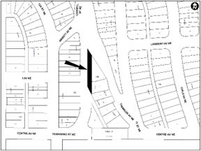
PLAN 2310980, AREA ‘A’ AND AREA ‘B’
LOC2022-0200
LAND USE REDESIGNATION
BYLAW 161D2023
To redesignate the land located at 202 Townsend Street NE and the closed road (Plan 720JK; Block 168; Lot 1; Plan 2310980, Area ‘A’ and Area ‘B’) from Residential – Contextual One / Two Dwelling (R-C2) District and Undesignated Road Right-of-Way to Residential – Contextual One / Two Dwelling (R-C2) District and Residential – Grade-Oriented Infill (R-CG) District.
CRESCENT HEIGHTS
LOC2023-0069
LAND USE REDESIGNATION
BYLAW 132D2023
To redesignate the land located at 240 – 7 Avenue NE (Plan 1332N, Block 18, Lots 21 and 22) from Residential – Contextual One / Two Dwelling (R-C2) District to Residential – Grade-Oriented Infill (R-CG) District.
LOC2023-0086
LAND USE REDESIGNATION
BYLAW 146D2023
To redesignate the land located at 201 – 10 Avenue NE (Plan 470P, Block 20, Lots 19 and 20) from Residential – Contextual One / Two Dwelling (R-C2) District to Residential – Grade-Oriented Infill (R-CG) District.
HIGHLAND PARK
LOC2023-0068
LAND USE REDESIGNATION
BYLAW 133D2023
To redesignate the land located at 3307 – 2 Street NE (Plan 5942AD, Block 4, Lots 39 and 40) from Residential – Contextual One / Two Dwelling (R-C2) District to Residential – Grade-Oriented Infill (R-CG) District.
RENFREW
LOC2023-0043
LAND USE REDESIGNATION
BYLAW 153D2023
To redesignate the land located at 1606 Russet Road NE (Plan 4221GL, Block 25, Lot 24) from Residential – Contextual One / Two Dwelling (R-C2) District to Housing – Grade Oriented (H-GO) District.
STONEGATE LANDING
LOC2023-0118
LAND USE REDESIGNATION
BYLAW 159D2023
To redesignate the land located at 12710 and 12774 Barlow Trail NE and 2825 and 2855 – 128 Avenue NE (Plan 1612601, Block 3, Lots 11 to 14) from Industrial – Business (I-B f0.5h27) District to Industrial – General (I-G) District.
ALTADORE
LOC2023-0064
LAND USE REDESIGNATION
BYLAW 135D2023
To redesignate the land located at 3803 and 3823 – 19 Street SW (Plan 4530AC, Block 6, Lots 1 to 4) from Residential – Contextual One / Two Dwelling (R-C2) District to Residential – Grade-Oriented Infill (R-CG) District.
LOC2023-0064
AMENDMENT TO THE SOUTH CALGARY/ALTADORE AREA REDEVELOPMENT PLANBYLAW 61P2023
The proposed amendment to the South Calgary/Altadore Area Redevelopment Plan would change the land use policy for the site located at 3803 and 3823 – 19 Street SW from Residential Conservation to Residential Low Density. This proposed policy amendment is in conjunction with the proposed land use redesignation for the site (Bylaw 135D2023). For further information, please contact 403-305-0297.
CLIFF BUNGALOW
LOC2023-0128
LAND USE REDESIGNATION
BYLAW 150D2023
To redesignate the land located at 534 – 23 Avenue SW (Plan 4453L, Block 6, a portion of Lot 20) from Multi-Residential – Contextual Grade-Oriented (M-CGd111) District to Direct Control (DC) District to accommodate Health Care Service.
KILLARNEY/GLENGARRY
LOC2023-0077
LAND USE REDESIGNATION
BYLAW 136D2023
To redesignate the land located at 3418 and 3422 Richmond Road SW (Plan 732GN, Block 1, Lot 5, a portion of Lot 4 and a portion of Lot 6) from Direct Control (DC) District to Residential – Contextual One / Two Dwelling (R-C2) District.
LOC2023-0051
LAND USE REDESIGNATION
BYLAW 143D2023
To redesignate the land located at 3410 Richmond Road SW (Plan 732GN, Block 1, a portion of Lot 2 and a portion of Lot 3) from Direct Control (DC) District to Residential – Contextual One / Two Dwelling (R-C2) District.
LOC2022-0209
LAND USE REDESIGNATION
BYLAW 149D2023
To redesignate the land located at 2604, 2608, 2612, 2616, 2620, 2628, 2632, 2636 and 2640 – 37 Street SW (Plan 4367X, Block 10E, Lots 21 to 30 and 33 to 40) from Mixed Use – General (MU-1f3.0h16) District to Mixed Use – Active Frontage (MU-2f4.0h26) District.
SHAGANAPPI
LOC2022-0180
LAND USE REDESIGNATION
BYLAW 152D2023
To redesignate the land located at 1408 – 27 Street SW (Plan 2311550, Block B, Lot 29) from Residential – Contextual One / Two Dwelling (R-C2) District and Multi-Residential – Contextual Medium Profile (M-C2f2.5) District to Mixed Use – General (MU-1f3.5h21) District.
SOUTH CALGARY
LOC2023-0037
LAND USE REDESIGNATION
BYLAW 141D2023
To redesignate the land located at 1720 – 33 Avenue SW (Plan 4479P, Block 61, Lots 9 and 10 and a portion of Lot 11) from Residential – Contextual One / Two Dwelling (R-C2) District to Housing – Grade Oriented (H-GO) District.
LOC2023-0037
AMENDMENT TO THE SOUTH CALGARY/ALTADORE AREA REDEVELOPMENT PLAN
BYLAW 62P2023
The proposed amendment to the South Calgary/Altadore Area Redevelopment Plan would change the land use policy for the site located at 1720 – 33 Avenue SW from Residential Conservation to Residential Medium Density. This proposed policy amendment is in conjunction with the proposed land use redesignation for the site (Bylaw 141D2023). For further information, please contact 403-512-0759.
WESTGATE
LOC2023-0097
LAND USE REDESIGNATION
BYLAW 142D2023
To redesignate the land located at 2 Westview Drive SW (Plan 2768HH, Block 22, Lot 29) from Residential – Contextual One Dwelling (R-C1) District to Direct Control (DC) District to accommodate a Child Care Service.
INGLEWOOD
LOC2022-0050
LAND USE REDESIGNATION
BYLAW 134D2023
To redesignate the land located at 2740 – 16A Street SE (Plan 7235AG, Block 25, Lot 20 and a portion of Lot 19) from Residential – Contextual One / Two Dwelling (R-C2) District to Residential – Grade-Oriented Infill (R-CG) District.
LOC2023-0020
ROAD CLOSURE
BYLAW 7C2023
The City of Calgary intends pursuant to s.22 of the Municipal Government Act to consider bylaws to close from use and sell or hold those portions of the streets, roads, lanes or public highways described here.
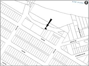
PLAN 2310859, AREA ‘A’
LOC2023-0020
LAND USE REDESIGNATION
BYLAW 137D2023
To redesignate the closed road adjacent to 1324 – 8 Avenue SE (Plan 2311017, Area ‘A’) from Undesignated Road Right-of-Way to Residential – Contextual One / Two Dwelling (R-C2) District.
LOC2022-0187
LAND USE REDESIGNATION
BYLAW 138D2023
To redesignate the land located at 1421 – 8 Avenue SE (Plan A3, Block 12, Lot 30) from Residential – Contextual One / Two Dwelling (R-C2) District to Direct Control (DC) District to accommodate the additional use of a School – Private.
MANCHESTER INDUSTRIAL
LOC2023-0110
LAND USE REDESIGNATION
BYLAW 151D2023
To redesignate the land located at 104 – 58 Avenue SE and 5723 – 1 Street SE (Plan 2853GN, Block 3, a portion of Lot 1; Plan 8710125, Block 3, Lot 7) from Commercial – Corridor 3 (C-COR3 f1.0h12) District and Industrial – General (I-G) District to Industrial – Business (I-Bf2.0h27) District.
RESIDUAL SUB-AREA 12K
LOC2023-0053
LAND USE REDESIGNATION
BYLAW 139D2023
To redesignate the land located at 9011 – 84 Street SE (Portion of Plan 4441AH, Block A) from Special Purpose – Future Urban Development (S-FUD) District to Direct Control (DC) District to accommodate a Storage Yard.
LOC2023-0085
LAND USE REDESIGNATION
BYLAW 140D2023
To redesignate the land located at 8400 – 84 Street SE (Plan 7510318, Block 2) from Special Purpose – Future Urban Development (S-FUD) District to Direct Control (DC) District to accommodate an Instructional Facility and Freight Yard.
AMENDMENTS TO THE LAND USE BYLAW 1P2007
BYLAW 65P2023
As part of the City’s commitment and priority to support businesses and economic recovery, amendments to the Land Use Bylaw are being proposed to streamline our Change of Use process. These changes will:
- Delete the uses of Accessory Food Service and Accessory Liquor Service to enable businesses to offer these as an accessory service or activity to their main/existing business, without the need for a development permit.
- Delete the use of Take Our Food Service and consolidate it into Restaurant: Food Service Only or Restaurant: Licensed.
- Remove a condition in the Commercial Office District that makes it easier to determine if a Use is permitted or discretionary.
- Remove the need for a development permit for permitted Change of Use in all commercial and mixed-use districts.
For further information, please contact Tammy Henry at: Tammy.Henry@calgary.ca
July 25 public hearing
BANFF TRAIL
LOC2022-0081
LAND USE REDESIGNATION
BYLAW 112D2023
To redesignate the land located at 1921 and 1925 – 24 Avenue NW (Plan 8100AF, Block 40, Lots 14 to 17) from Residential – Contextual One / Two Dwelling (R-C2) District to Mixed Use – General (MU-1f1.5h12) District.
LOC2022-0081
AMENDMENT TO THE BANFF TRAIL AREA REDEVELOPMENT PLAN
BYLAW 40P2023
The proposed amendment to the Banff Trail Area Redevelopment Plan would change the land use policy for the sites located at 1921 and 1925 – 24 Avenue NW to allow for mixed-use development. This proposed policy amendment is in conjunction with the proposed land use redesignation for the site (Bylaw 112D2023). For further information, please contact 403-808-6189.
LOC2023-0045
LAND USE REDESIGNATION
BYLAW 113D2023
To redesignate the land located at 2236 – 24 Avenue NW (Plan 3690AR, Block 10, Lots 11 and 12) from Residential – Contextual One / Two Dwelling (R-C2) District to Housing – Grade Oriented (H-GO) District.
CAPITOL HILL
LOC2023-0048
LAND USE REDESIGNATION
BYLAW 114D2023
To redesignate the land located at 1531 – 20 Avenue NW (Plan 2864AF, Block 4, Lot 25 and a portion of Lot 26) from Residential – Contextual One / Two Dwelling (R-C2) District to Housing – Grade-Oriented (H-GO) District.
HILLHURST
LOC2023-0024
LAND USE REDESIGNATION
BYLAW 111D2023
To redesignate the land located at 1802 and 1808 Westmount Road NW (Plan 5151O, Block 3, Lots 1 to 4) from Residential – Contextual One / Two Dwelling (R-C2) District to Housing – Grade Oriented (H-GO) District.
LOC2023-0024
AMENDMENT TO THE HILLHURST/SUNNYSIDE AREA REDEVELOPMENT PLAN
BYLAW 39P2023
The proposed amendment to the Hillhurst/Sunnyside Area Redevelopment Plan would change the land use policy for the site located at 1921 and 1925 – 24 Avenue NW to allow for medium-density development in the form of grade-oriented housing. This proposed policy amendment is in conjunction with the proposed land use redesignation for the site (Bylaw 111D2023). For further information, please contact 403-808-6189.
LOC2023-0005
LAND USE REDESIGNATION
BYLAW 122D2023
To redesignate the land located at 321 – 10 Street NW (Plan 5609J, Block J, Lots 21 to 24) from Commercial – Corridor 1 (C-COR-1f2.8h13) District to Direct Control (DC) District to accommodate mixed-use development.
LOC2023-0005
AMENDMENT TO THE HILLHURST/SUNNYSIDE AREA REDEVELOPMENT PLAN
BYLAW 44P2023
The proposed amendments to the Hillhurst/Sunnyside Area Redevelopment Plan would change the allowable building height and density for the site located at 321 – 10 Street NW. The amendments include text and map changes that would allow a maximum height of 29 metres and a maximum FAR of 5.0, with density bonusing on the subject site. The proposed policy amendments are in conjunction with the proposed land use redesignation for the site (Bylaw 122D2023) For further information, please contact 587-576-3085.
MONTGOMERY
LOC2023-0040
LAND USE REDESIGNATION
BYLAW 106D2023
To redesignate the land located at 5124 – 17 Avenue NW (Plan 67GN, Block 2, Lot 20) from Residential – Contextual One Dwelling (R-C1) District to Residential – Grade-Oriented Infill (R-CG) District.
LOC2023-0040
AMENDMENT TO THE MONTGOMERY AREA REDEVELOPMENT PLAN
BYLAW 38P2023
The proposed amendments to the Montgomery Area Redevelopment Plan would change the land use policy for the site located at 5124 – 17 Avenue NW to allow for infill development. This proposed policy amendment is in conjunction with the proposed land use redesignation for the site (Bylaw 106D2023). For further information, please contact 403-815-4326.
MOUNT PLEASANT
LOC2023-0047
LAND USE REDESIGNATION
BYLAW 115D2023
To redesignate the land located at 466 – 29 Avenue NW (Plan 2617AG, Block 44, Lots 33 and 34) from Multi-Residential – Contextual Low Profile (M-C1) District to Housing – Grade Oriented (H-GO) District.
RESIDUAL SUB-AREA 02L
LOC2020-0212
ROAD CLOSURE
BYLAW 5C2023
The City of Calgary intends pursuant to s.22 of the Municipal Government Act to consider bylaws to close from use and sell or hold those portions of the streets, roads, lanes or public highways described here.
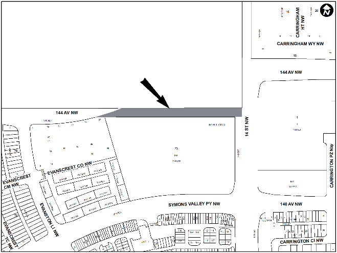
PLAN 2310859, AREA ‘A’
LOC2020-0212
LAND USE REDESIGNATION
BYLAW 110D2023
To redesignate the land located at 15353 – 14 Street NW, 1600 – 144 Avenue NW, and the closed road (Portion of NE1/4 5-1-26-5, Portion of SE1/4 5-1-26-5; Plan 2310859, Area ‘A’) from Special Purpose – Future Urban Development (S-FUD) District and Undesignated Road Right-of-Way to Residential – Low Density Mixed Housing (R-G) District, Residential – Low Density Mixed Housing (R-Gm) District, Special Purpose – City and Regional Infrastructure (S-CRI) District, Special Purpose – School, Park and Community Reserve (S-SPR) District, and Special Purpose – Urban Nature (S-UN) District.
UNIVERSITY HEIGHTS
LOC2022-0170
LAND USE REDESIGNATION
BYLAW 123D2023
To redesignate the land located at 1941 Uxbridge Drive NW (Plan 1612084, Block 1, Lot 1) From Direct Control District (DC) District to Direct Control (DC) District to accommodate mixed-use development.
LOC2022-0170
AMENDMENT TO THE STADIUM SHOPPING CENTRE AREA REDEVELOPMENT PLAN
BYLAW 45P2023
The proposed amendments to the Stadium Shopping Centre Area Redevelopment Plan change the land use policy for the site located at 1941 Uxbridge Drive NW to allow for clarity of Health uses terminology, consistency with the proposed Direct Control (DC) District and increase the use area for the Health uses for the site. This proposed policy amendment is in conjunction with the proposed land use redesignation for the site (Bylaw 123D2023). For further information, please contact 403-808-9141.
LOC2022-0170
AMENDMENT TO ATTACHMENT 1 OF THE STADIUM SHOPPING CENTRE AREA REDEVELOPMENT PLAN
The proposed amendment to the Appendix 1 of the Stadium Shopping Centre Area Redevelopment Plan applicable to the site located at 1941 Uxbridge Drive NW to include a new definition for Health uses is to allow for consistency, clarity in the Area Redevelopment Plan and align with the proposed DC District. For further information, please contact 403-808-9141.
BRIDGELAND/RIVERSIDE
LOC2023-0055
LAND USE REDESIGNATION
BYLAW 100D2023
To redesignate the land located at 502 – 9A Street NE (Plan 8150AN, Block 145, Lot 16) from Residential – Contextual One / Two Dwelling (R-C2) District to Housing – Grade Oriented (H-GO) District.
LOC2023-0055
AMENDMENT TO THE BRIDGELAND/RIVERSIDE AREA REDEVELOPMENT PLAN
BYLAW 36P2023
The proposed amendment to the Bridgeland-Riverside Area Redevelopment Plan is to change a residential land use policy pertaining to the Conservation Area to accommodate low density multi-residential development in the form of rowhouses, townhouses and stacked townhouses at 502 – 9A Street NE. This proposed policy amendment is in conjunction with the proposed land use redesignation for the site (Bylaw 100D2023). For further information, please contact 403-268-3695.
LEWISBURG
LOC2022-0150
LAND USE REDESIGNATION
BYLAW 109D2023
To redesignate the land located at 14310 – 6 Street NE (Plan 8710707, RW, (portion of NW1/4 35-25-1- 5)) from Special Purpose – Future Urban Development (S-FUD) District to Residential – Low Density Mixed Housing (R-G) District.
RENFREW
LOC2023-0016
LAND USE REDESIGNATION
BYLAW 105D2023
To redesignate the land located at 1408 Renfrew Drive NE (Plan 1838GT, Block 1, Lot 1) from Residential – Contextual One / Two Dwelling (R-C2) District to Residential – Grade-Oriented Infill (R-CG) District.
RESIDUAL SUB-AREA 09O
LOC2021-0202
LAND USE REDESIGNATION
BYLAW 116D2023
To redesignate the land located at 655 – 100 Street NE (Plan 1014764, Block 3, Lot 1) from Special Purpose – Future Urban Development (S-FUD) District to Residential – Low Density Mixed Housing (R-G) District, Residential – Low Density Mixed Housing (R-Gm) District, Commercial – Neighbourhood 1 (C-N1) District, Mixed Use – General (MU-1h16) District, Special Purpose – City and Regional Infrastructure (S-CRI) District, Special Purpose – School, Park and Community Reserve (S-SPR) District, and Special Purpose – Urban Nature (S-UN) District.
LOC2021-0212
LAND USE REDESIGNATION
BYLAW 117D2023
To redesignate the land located at 800 and 892 – 84 Street NE (Plan 2310757, Block 50, Lot 1; Plan 0912631, Block C) from Special Purpose – Future Urban Development (S-FUD) District to Residential – Low Density Mixed Housing (R-G) District, Residential – Low Density Mixed Housing (R-Gm) District, Special Purpose – City and Regional Infrastructure (S-CRI) District, Special Purpose – School, Park and Community Reserve (S-SPR) District, Special Purpose – Urban Nature (S-UN) District and Direct Control (DC) District to accommodate street-oriented residential development on small lots.
RESIDUAL SUB-AREA 10E
LOC2022-0091
LAND USE REDESIGNATION
BYLAW 99D2023
To redesignate the land located at 2705R – 84 Street NE (Plan 8411222, portion of Block 1) from Special Purpose – Future Urban Development (S-FUD) District to Special Purpose – Urban Nature (S-UN) District and Direct Control (DC) District to accommodate an asphalt, aggregate and concrete plant.
SADDLERIDGE
LOC2023-0033
LAND USE REDESIGNATION
BYLAW 108D2023
To redesignate the land located at 5111 and 5123 – 85 Avenue NE (Plan 1211515, Block 37, Lots 1 and 2) from Multi-Residential – Medium Profile Support Commercial (M-X2) District to Multi-Residential – Medium Profile (M-2) District.
ALTADORE
LOC2023-0015
LAND USE REDESIGNATION
BYLAW 94D2023
To redesignate the land located at 1743 and 1747 – 36 Avenue SW (Plan 1497BC, Block 16, Lots 21 to 24) from Multi-Residential – Contextual Grade-Oriented (M-CGd72) District to Housing – Grade Oriented (H-GO) District.
LOC2023-0015
AMENDMENT TO THE SOUTH CALGARY/ALTADORE AREA REDEVELOPMENT PLAN
BYLAW 35P2023
The proposed amendment to the South Calgary/Altadore Area Redevelopment Plan would change the land use policy for the site located at 1743 and 1747 – 36 Avenue SW (Plan 1497BC, Block 16, Lots 21 to 24) from ‘Residential Low Density’ to ‘Residential Medium Density’. This proposed policy amendment is in conjunction with the proposed land use redesignation for the site (Bylaw 94D2023). For further information, please contact 403-804-0790.
LOC2022-0121
LAND USE REDESIGNATION
BYLAW 104D2023
To redesignate the land located at 2048 – 43 Avenue SW (Plan 6290AJ, Block 7, Lots 49, 50 and a portion of Lot 48) from Residential – Contextual One / Two Dwelling (R-C2) District to Residential – Grade-Oriented Infill (R-CG) District.
LOC2022-0121
AMENDMENT TO THE SOUTH CALGARY/ALTADORE AREA REDEVELOPMENT PLAN
BYLAW 37P2023
The proposed amendment to the South Calgary/Altadore Area Redevelopment Plan would change the land use policy for the site located at 2048 – 43 Avenue SW from ‘Residential Conservation’ to ‘Residential Low Density’. This proposed policy amendment is in conjunction with the proposed land use redesignation for the site (Bylaw 104D2023). For further information, please contact 403-268-5311.
ASPEN WOODS
LOC2023-0003
LAND USE REDESIGNATION
BYLAW 120D2023
To redesignate the land located at 7111 – 14 Avenue SW (Plan 9410843, Block A, Lot 13) from Direct Control (DC) District to Multi-Residential – Low Profile (M-1) District.
LOC2023-0003
AMENDMENT TO THE EAST SPRINGBANK AREA STRUCTURE PLAN
BYLAW 42P2023
The proposed amendment to the East Springbank Area Structure Plan would add a site-specific amendment within Section 2.2.3 Policies for the site located at 7111 – 14 Avenue SW which would indicate that a maximum density of 148 units per hectare (60 units per acre) and a maximum height of 4 storeys would be permitted. This proposed policy amendment is in conjunction with the proposed land use redesignation for the site (Bylaw 120D2023). For further information, please contact 403-268-5344.
DOWNTOWN WEST END
LOC2023-0014
LAND USE REDESIGNATION
BYLAW 118D2023
To redesignate the land located at 855 and 887 – 10 Street SW, 850 – 11 Street SW, 1127 – 8 Avenue SW and 1110 – 9 Avenue SW (Plan 2110834, Block 56, Lots 43 to 46; Plan 1513418, Block 56, Lot 42) from Direct Control (DC) District to Direct Control (DC) District to accommodate mixed-use development.
GLENDALE
LOC2022-0185
LAND USE REDESIGNATION
BYLAW 96D2023
To redesignate the land located at 2431 – 37 Street SW and 3804 – 25 Avenue SW (Plan 2860GR, Block 2, Lots 8 and 9) from Multi-Residential – Contextual Low Profile (M-C1) District to Mixed Use – General (MU-1f3.0h16) District.
LOC2023-0021
LAND USE REDESIGNATION
BYLAW 103D2023
To redesignate the land located at 2723 – 40 Street SW (Plan 4216HE, Block 3, Lot 15) from Residential – Contextual One Dwelling (R-C1) District to Residential – Contextual One / Two Dwelling (R-C2) District.
KILLARNEY/GLENGARRY
LOC2022-0216
LAND USE REDESIGNATION
BYLAW 97D2023
To redesignate the land located at 2028, 2032, 2036 and 2040 – 37 Street SW (Plan 6900AM, Block 5F, Lots 33 to 40) from Multi-Residential – Contextual Low Profile (M-C1) District to Mixed Use – General (MU-1f3.5h24) District.
MANCHESTER
LOC2022-0219
LAND USE REDESIGNATION
BYLAW 121D2023
To redesignate the land located at 5702, 5706, 5712, 5714, and 5716 – 2 Street SW (Plan 5454AC, Block 26, Lots 13 to 20) from Direct Control (DC) District to Direct Control (DC) District to accommodate a mixed-use development.
LOC2022-0219
AMENDMENT TO THE MANCHESTER AREA REDEVELOPMENT PLAN
BYLAW 43P2023
The proposed amendment to the Manchester Area Redevelopment Plan is to accommodate a mixed-use development located at 5702, 5706, 5712, 5714, and 5716 – 2 Street SW. The amendments would exempt the sites from the maximum density listed in Section 1.4.3 subsection 2 to support the proposed higher density development. This proposed policy amendment is in conjunction with the proposed land use redesignation for the sites (Bylaw 121D2023). For further information, please contact 403-200-8575.
MEDICINE HILL
LOC2022-0148
LAND USE REDESIGNATION
BYLAW 95D2023
To redesignate the land located at 1201 Na’a Drive SW (Plan 1612946, Block 3, Lot 5) from Residential – Low Density Multiple Dwelling (R-2M) District to Multi-Residential – At Grade Housing (M-Gd50) District.
WEST SPRINGS
LOC2022-0123
LAND USE REDESIGNATION
BYLAW 119D2023
To redesignate the land located at 949 – 77 Street SW (Plan 8810945, Block 1, Lot 1) from Direct Control (DC) District to Residential – One Dwelling (R-1s) District and Residential – Low Density Mixed Housing (R-G) District.
LOC2022-0123
AMENDMENT TO THE WEST SPRINGS AREA STRUCTURE PLAN
BYLAW 41P2023
The proposed amendment to the West Springs Area Structure Plan would change the land use policy for the site located at 949 – 77 Street SW from Urban Development to Medium Density. This proposed policy amendment is in conjunction with the proposed land use redesignation for the site (Bylaw 119D2023). For further information, please contact 403-268-5344.
WINDSOR PARK
LOC2022-0201
LAND USE REDESIGNATION
BYLAW 93D2023
To redesignate the land located at 637 – 51 Avenue SW (Plan 1693AF, Block 8, Lots 19 and 20) from Residential – Contextual One / Two Dwelling (R-C2) District to Residential – Grade-Oriented Infill (R-CG) District.
LOC2023-0083
LAND USE REDESIGNATION
BYLAW 102D2023
To redesignate the land located at 640 – 52 Avenue SW (Plan 1693AF, Block 8, Lots 21 to 23) from Residential – Contextual One / Two Dwelling (R-C2) District to Residential – Grade-Oriented Infill (R-CG) District.
ACADIA
LOC2023-0072
LAND USE REDESIGNATION
BYLAW 101D2023
To redesignate the land located at 9103 Fairmount Drive SE (Plan 2303ID, Block 19, Lot 10) from Direct Control (DC) District to Residential – Contextual One Dwelling (R-C1) District.
BELVEDERE
LOC2022-0159
LAND USE REDESIGNATION
BYLAW 125D2023
To redesignate the land located at 2313 – 84 Street SE (NE1/4 Section 12-24-29-4) from Direct Control (DC) District to Residential – Low Density Mixed Housing (R-G) District, Residential – Low Density Mixed Housing (R-Gm) District, Multi-Residential – Medium Profile (M-2) District, Multi-Residential – High Density Medium Rise (M-H2h40) District, Special Purpose – City and Regional Infrastructure (S-CRI) District, Special Purpose School, Park and Community Reserve (S-SPR) District.
LOC2022-0159
AMENDMENT TO THE BELVEDERE AREA STRUCTURE PLAN
BYLAW 46P2023
The proposed amendments to the Belvedere Area Structure Plan would change the land use policy for the site located at 2313 – 84 Street SE from Super Regional Retail Centre to Neighbourhood Area. This proposed policy amendment is in conjunction with the proposed land use redesignation for the site (Bylaw 125D2023). For further information, please contact 403-826-0454.
HIGHFIELD INDUSTRIAL
LOC2022-0212
LAND USE REDESIGNATION
BYLAW 98D2023
To redesignate the land located at 808 – 42 Avenue SE (Plan 0814304, Block 1, Lot 1) from Industrial – General (I-G) to Industrial – Commercial (I-C) District.
SECTION 23 INDUSTRIAL
LOC2023-0038
LAND USE REDESIGNATION
BYLAW 107D2023
To redesignate the land located at 5526 – 94 Avenue SE (Plan 8055AG, Block 1, Lot 9 and 11) from Direct Control (DC) District to Industrial – General (I-G) District.
SOUTH FOOTHILLS
LOC2022-0127
ROAD CLOSURE
BYLAW 6C2023
The City of Calgary intends pursuant to s.22 of the Municipal Government Act to consider bylaws to close from use and sell or hold those portions of the streets, roads, lanes or public highways described here.
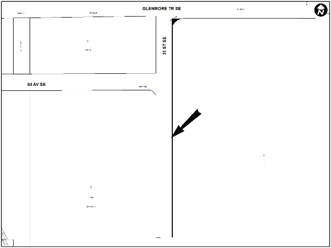
PLAN 2311121, AREA ‘A’
LOC2022-0127
LAND USE REDESIGNATION
BYLAW 124D2023
To redesignate the land located at 8919 Barlow Trail SE, and the closed road (Plan 1211046, Block 2, Lot 2; Plan 2311121, Area ‘A’) from Industrial – Heavy (I-H) District and Undesignated Road Right-of-Way to Special Purpose – City and Regional Infrastructure (S-CRI) District and Direct Control (DC) District to accommodate industrial developments.
AMENDMENTS TO THE MUNICIPAL DEVELOPMENT PLAN
BYLAW 47P2023
A policy amendment is proposed to the Municipal Development Plan to remove the Growth Management Overlay in its policies in response to the New Approach to Growth Applications. This amendment includes deleting the entire Volume 2, Part 1, Section 4.3 entitled “Urban Growth Policies”, and replacing with updated policies for Growth Applications, to enable an evaluation and decision-making process for strategic growth in new communities. For further information, please contact 403-268-3261.
AMENDMENTS TO THE BELVEDERE AREA STRUCTURE PLAN
BYLAW 48P2023
A policy amendment is proposed to the Belvedere Area Structure Plan to remove mention of the Growth Management Overlay in its policies in response to the New Approach to Growth Applications. This amendment includes deleting the entire Section 5.1 entitled “Urban Growth Policies” and deleting the existing Map 4 entitled “Growth Management Overlay”. Refer to the proposed policy amendment to the Municipal Development Plan (proposed Bylaw 47P2023) for updated policies related to growth. For further information, please contact 403-268-3261.
AMENDMENTS TO THE CORNERSTONE AREA STRUCTURE PLAN
BYLAW 49P2023
A policy amendment is proposed to the Cornerstone Area Structure Plan to remove mention of the Growth Management Overlay in its policies in response to the New Approach to Growth Applications. This amendment includes deleting the entire Section 7.1 entitled “Growth Management”, deleting the existing Map 11 entitled “Growth Management Overlay”, and other related textual amendments. Refer to the proposed policy amendment to the Municipal Development Plan (proposed Bylaw 47P2023) for updated policies related to growth. For further information, please contact 403-268-3261.
AMENDMENTS TO THE EAST STONEY AREA STRUCTURE PLAN
BYLAW 50P2023
A policy amendment is proposed to the East Stoney Area Structure Plan to remove mention of the Growth Management Overlay in its policies in response to the New Approach to Growth Applications. This amendment includes deleting the entire Section 8.3 entitled “Growth Management”, deleting the existing Map 7 entitled “Growth Management Overlay”, and other related textual amendments. Refer to the proposed policy amendment to the Municipal Development Plan (proposed Bylaw 47P2023) for updated policies related to growth. For further information, please contact 403-268-3261.
AMENDMENTS TO THE GLACIER RIDGE AREA STRUCTURE PLAN
BYLAW 51P2023
A policy amendment is proposed to the Glacier Ridge Area Structure Plan to remove mention of the Growth Management Overlay in its policies in response to the New Approach to Growth Applications. This amendment includes deleting the entire Section 7.2 entitled “Growth Management”, deleting the existing Map 10 entitled “Growth Management Overlay”, and other related textual amendments. Refer to the proposed policy amendment to the Municipal Development Plan (proposed Bylaw 47P2023) for updated policies related to growth. For further information, please contact 403-268-3261.
AMENDMENTS TO THE HASKAYNE AREA STRUCTURE PLAN
BYLAW 52P2023
A policy amendment is proposed to the Haskayne Area Structure Plan to remove mention of the Growth Management Overlay in its policies in response to the New Approach to Growth Applications. This amendment includes deleting the entire Section 7.2 entitled “Growth Management” and deleting the existing Map 10 entitled “Growth Management Overlay”. Refer to the proposed policy amendment to the Municipal Development Plan (proposed Bylaw 47P2023) for updated policies related to growth. For further information, please contact 403-268-3261.
AMENDMENTS TO THE KEYSTONE HILLS AREA STRUCTURE PLAN
BYLAW 53P2023
A policy amendment is proposed to the Keystone Hills Area Structure Plan to remove mention of the Growth Management Overlay in its policies in response to the New Approach to Growth Applications. This amendment includes deleting the entire Section 5.1 entitled “Urban Growth Policies”, deleting the existing Map 4 entitled “Growth Management Overlay”, and other related textual amendments. Refer to the proposed policy amendment to the Municipal Development Plan (proposed Bylaw 47P2023) for updated policies related to growth. For further information, please contact 403-268-3261.
AMENDMENTS TO THE NOSE CREEK AREA STRUCTURE PLAN
BYLAW 54P2023
A policy amendment is proposed to the Nose Creek Area Structure Plan to remove mention of the Growth Management Overlay in its policies in response to the New Approach to Growth Applications. This amendment includes deleting the entire Section 11.2 entitled “Growth Management”, deleting the existing Map 13 entitled “Growth Management Overlay”, and other related textual amendments. Refer to the proposed policy amendment to the Municipal Development Plan (proposed Bylaw 47P2023) for updated policies related to growth. For further information, please contact 403-268-3261.
AMENDMENTS TO THE PROVIDENCE AREA STRUCTURE PLAN
BYLAW 55P2023
A policy amendment is proposed to the Providence Area Structure Plan to remove mention of the Growth Management Overlay in its policies in response to the New Approach to Growth Applications. This amendment includes deleting the entire Section 9.1 entitled “Growth Management”, deleting the existing Map 10 entitled “Growth Management Overlay”, and other related textual amendments. Refer to the proposed policy amendment to the Municipal Development Plan (proposed Bylaw 47P2023) for updated policies related to growth. For further information, please contact 403-268-3261.
AMENDMENTS TO THE RANGEVIEW AREA STRUCTURE PLAN
BYLAW 56P2023
A policy amendment is proposed to the Rangeview Area Structure Plan to remove mention of the Growth Management Overlay in its policies in response to the New Approach to Growth Applications. This amendment includes deleting the entire Section 8.2 entitled “Growth Management”, deleting the existing Map 10 entitled “Growth Management Overlay”, and other related textual amendments. Refer to the proposed policy amendment to the Municipal Development Plan (proposed Bylaw 47P2023) for updated policies related to growth. For further information, please contact 403-268-3261.
AMENDMENTS TO THE RICARDO RANCH AREA STRUCTURE PLAN
BYLAW 57P2023
A policy amendment is proposed to the Ricardo Ranch Area Structure Plan to remove mention of the Growth Management Overlay in its policies in response to the New Approach to Growth Applications. This amendment includes deleting the entire Section 7.3 entitled “Strategic Growth” and deleting the existing Map 12 entitled “Growth Management Overlay”. Refer to the proposed policy amendment to the Municipal Development Plan (proposed Bylaw 47P2023) for updated policies related to growth. For further information, please contact 403-268-3261.
AMENDMENTS TO THE SOUTH SHEPARD AREA STRUCTURE PLAN
BYLAW 58P2023
A policy amendment is proposed to the South Shepard Area Structure Plan to remove mention of the Growth Management Overlay in its policies in response to the New Approach to Growth Applications. This amendment includes deleting the entire Section 8.4 entitled “Urban Growth Policies” and deleting the existing Map 14 entitled “Growth Management Overlay”. Refer to the proposed policy amendment to the Municipal Development Plan (proposed Bylaw 47P2023) for updated policies related to growth. For further information, please contact 403-268-3261.
AMENDMENTS TO THE WEST VIEW AREA STRUCTURE PLAN
BYLAW 59P2023
A policy amendment is proposed to the West View Area Structure Plan to remove mention of the Growth Management Overlay in its policies in response to the New Approach to Growth Applications. This amendment includes deleting the entire Section 8.2 entitled “Strategic Growth” and deleting the existing Map 9 entitled “Growth Management Overlay”. Refer to the proposed policy amendment to the Municipal Development Plan (proposed Bylaw 47P2023) for updated policies related to growth. For further information, please contact 403-268-3261.
January 17 public hearing
Hillhurst
LOC2022-0006
LAND USE REDESIGNATION
BYLAW 4D2023
To redesignate the land located at 120 – 10A Street NW (Condominium Plan 9211275, Units 1 to 81) from Commercial – Corridor 1 f2.8h13 (C-COR1f2.8h13) District to Direct Control (DC) District to accommodate the height and density of the existing building.
LOC2022-0006
AMENDMENT TO THE HILLHURST/SUNNYSIDE AREA REDEVELOPMENT PLAN
BYLAW 1P2023
The proposed amendments to the Hillhurst/Sunnyside Area Redevelopment Plan would change the land use policy for the site located at 120 – 10A Street NW to reflect the height and density of the existing building. This proposed policy amendment is in conjunction with the proposed land use redesignation for the site (Bylaw 4D2023). For further information, please contact 587-284-7444.
Mount Pleasant
LOC2022-0107
LAND USE REDESIGNATION
BYLAW 1D2023
To redesignate the land located at 926 – 20 Avenue NW (Plan 2934O, Block 25, Lot 13) from Residential – Contextual One / Two Dwelling (R-C2) District to Residential – Grade-Oriented Infill (R-CG) District.
Tuxedo Park
LOC2022-0168
LAND USE REDESIGNATION
BYLAW 6D2023
To redesignate the land located at 257 – 22 Avenue NW (Plan 2129O, Block 25, Lots 30 and 31) from Residential – Contextual One/Two Dwelling (R-C2) District to Residential – Grade-Oriented Infill (R-CG) District.
Martindale
LOC2022-0147
LAND USE REDESIGNATION
BYLAW 5D2023
To redesignate the land located at 1203 Martindale Boulevard NE (Plan 9913410, Block 36, Lot 4) from Residential – Contextual Narrow Parcel One Dwelling (R-C1N) District to Direct Control (DC) District to allow the additional discretionary use of Child Care Service.
Altadore
LOC2022-0130
LAND USE REDESIGNATION
BYLAW 10D2023
To redesignate the land located at 3714, 3718, 3722 and 3726 – 14A Street SW (Plan 1965P, Block A, Lots 16 to 22) from Residential – Contextual One / Two Dwelling (R-C2) to Multi-Residential – Contextual Grade-Oriented (M-CG) District.
LOC2022-0130
AMENDMENT TO THE SOUTH CALGARY/ALTADORE AREA REDEVELOPMENT PLAN
BYLAW 2P2023
The proposed amendments to the South Calgary/Altadore Area Redevelopment Plan would change the land use policy for the site located at 3714, 3718, 3722 and 3726 – 14A Street SW from Residential Conservation to Residential Medium Density and amend the text amendment to Section 2.3.4, to indicate that the M-CG designation is appropriate at the subject site. The proposed policy amendments are in conjunction with the proposed land use redesignation for the site (Bylaw 10D2023). For further information, please contact 403-268-5344.
North Glenmore Park
LOC2022-0162
LAND USE REDESIGNATION
BYLAW 2D2023
To redesignate the land located at 2039 - 55 Avenue SW (Plan 5259HR, Block 27, Lot 2) from Residential – Contextual One Dwelling (R-C1) District to Residential – Contextual One / Two Dwelling (R-C2) District.
LOC2022-0161
LAND USE REDESIGNATION
BYLAW 3D2023
To redesignate the land located at 5604 - 20 Street SW (Plan 5259HR Block 27, Lot 1) from Residential – Contextual One Dwelling (R-C1) District to Residential – Contextual One / Two Dwelling (R-C2) District.
Shaganappi
LOC2022-0079
LAND USE REDESIGNATION
BYLAW 9D2023
To redesignate the land located at t 3115 – 12 Avenue SW (Plan 8033FW, Lot 2) from Residential – Contextual One / Two Dwelling (R-C2) District to Housing – Grade Oriented (H-GO) District.
Inglewood
LOC2022-0129
LAND USE REDESIGNATION
BYLAW 11D2023
To redesignate the land located at 1204, 1210, 1212 and 1216 – 11 Avenue SE (Plan A3, Block 21, Lots 11 to 16) from Commercial – Corridor 2 f2.8h12 (C-COR2 f2.8h12) District to Mixed Use - General (MU-1f6.5h45) District.
LOC2022-0129
AMENDMENT TO THE INGLEWOOD AREA REDEVELOPMENT PLAN
BYLAW 3P2023
The proposed amendments to the Inglewood Area Redevelopment Plan are to accommodate an integrated mixed-use development including a fire station located at 1204, 1210, 1212, 1216 – 11 Avenue SE. The policy amendments include replacement of Map 8 entitled ‘Sites Requiring Redesignations Commercial/Industrial’ and amendments to the development guidelines within Table 3 entitled ‘Proposed Commercial/Industrial Redesignations’. The proposed policy amendments are in conjunction with the proposed land use redesignation for the site (Bylaw 11D2023). For further information, please contact 403-200-8575.
Seton
LOC2021-0177
LAND USE REDESIGNATION
BYLAW 8D2023
To redesignate the land located at 17770R – 56 Street SE, 18150 – 56 Street SE and 19050 – 40 Street SE (Plan 0411571; Block A; portion of SW1/4 Section 22-22-29-4; portion of SE1/4 Section 21-22-29-4) from Direct Control District to Mixed Use - General (MU-1h24) District and Direct Control (DC) District to accommodate a food and drink hall and to provide custom regulations for mixed-use developments.
Starfield East
LOC2022-0087
LAND USE REDESIGNATION
BYLAW 7D2023
To redesignate the land located at 4920 – 68 Street SE (Portion of SE1/4 Section 1-24-29-4) from Industrial – General (I-G) District to Direct Control (DC) District to accommodate a bioethanol plant and cogeneration facility.
Valleyfield
LOC2022-0115
LAND USE REDESIGNATION
BYLAW 12D2023
To redesignate the land located at 2526 and 2502 – 50 Avenue SE, 2539 – 49 Avenue SE, 5002 – 24 Street SE, 4990 and 5020 Barlow Trail SE (Plan 4724R, Block A, Lots 1 to 44; Plan 4724R, Block A, OT) from Direct Control (DC) District to Industrial – General (I-G) District.
LOC2022-0115
AMENDMENT TO THE SOUTHEAST INDUSTRIAL AREA STRUCTURE PLAN
BYLAW 4P2023
This proposal is to amend the Southeast Industrial Area Structure Plan in order to accommodate industrial development at 2502 and 2526 – 50 Avenue SE, 2539 – 49 Avenue SE, 5002 – 24 Street SE, and 4990 and 5020 Barlow Trail SE. The amendment will change the property’s land use category from ‘Existing Commercial District’ to ‘Proposed I-2 General Light Industrial District’ to allow for industrial based development. The proposed policy amendments are in conjunction with the proposed land use redesignation for the site (Bylaw 12D2023), please contact 403-804-0459 for further information.
Citywide
IP2022-1146
WESTBROOK COMMUNITIES LOCAL AREA PLAN
BYLAW 5P2023
The proposed Westbrook Communities Local Area Plan is a new long-range, statutory plan (area redevelopment plan) that is intended to provide a comprehensive planning vision and development policies for the communities of Glenbrook, Glendale, Killarney/Glengarry, Richmond (west of Crowchild Trail SW and north of 33 Avenue SW), Rosscarrock, Shaganappi, Spruce Cliff, Westgate, Wildwood and Scarboro/Sunalta West (west of Crowchild Trail SW). The Plan takes a multi-community approach that recognizes and builds upon the shared assets and features that connect these inner-city and established communities including infrastructure, recreational amenities, public parks and open space, Main Streets, corridors, transit station areas and Activity Centres. For further information, please contact 403-804-5904.
IP2022-1146
AMENDMENTS TO THE RICHMOND AREA REDEVELOPMENT PLAN
BYLAW 6P2023
Amendments to the Richmond Area Redevelopment Plan are proposed in conjunction with the proposed Westbrook Communities Local Area Plan. The proposed amendments would remove the area to the west of Crowchild Trail SW from the Richmond Area Redevelopment Plan. The area to the west of Crowchild Trail SW is proposed to be included within the Westbrook Communities Local Area Plan. For further information, please contact 403-804-5904.
C2023-0006
AMENDMENTS TO THE GLACIER RIDGE AREA STRUCTURE PLAN
BYLAW 7P2023
A policy amendment is proposed to the Glacier Ridge Area Structure Plan to remove Growth Management Overlay for several parcels. This amendment includes replacing the existing Map 10 entitled “Growth Management Overlay” with an updated Map 10 entitled “Growth Management Overlay” that includes a larger Growth Management Overlay Removal Area and new polygons “A” and “B”. A new policy 7.2.3 will also be added, which will ensure planning approvals remain in alignment with servicing capacity. For further information, please contact 403-268-3261.
C2023-0006
AMENDMENTS TO THE RANGEVIEW AREA STRUCTURE PLAN
BYLAW 8P2023
A policy amendment is proposed to the Rangeview Area Structure Plan to remove Growth Management Overlay for several parcels. This amendment includes replacing the existing Map 10 entitled “Growth Management Overlay” with an updated Map 10 entitled “Growth Management Overlay” that includes a larger Growth Management Overlay Removed area. For further information, please contact 403-268-3261.
AMENDMENTS TO THE MUNICIPAL DEVELOPMENT PLAN
BYLAW 47P2023
A policy amendment is proposed to the Municipal Development Plan to remove the Growth Management Overlay in its policies in response to the New Approach to Growth Applications. This amendment includes deleting the entire Volume 2, Part 1, Section 4.3 entitled “Urban Growth Policies”, and replacing with updated policies for Growth Applications, to enable an evaluation and decision-making process for strategic growth in new communities. For further information, please contact 403-268-3261.
AMENDMENTS TO THE BELVEDERE AREA STRUCTURE PLAN
BYLAW 48P2023
A policy amendment is proposed to the Belvedere Area Structure Plan to remove mention of the Growth Management Overlay in its policies in response to the New Approach to Growth Applications. This amendment includes deleting the entire Section 5.1 entitled “Urban Growth Policies” and deleting the existing Map 4 entitled “Growth Management Overlay”. Refer to the proposed policy amendment to the Municipal Development Plan (proposed Bylaw 47P2023) for updated policies related to growth. For further information, please contact 403-268-3261.
AMENDMENTS TO THE CORNERSTONE AREA STRUCTURE PLAN
BYLAW 49P2023
A policy amendment is proposed to the Cornerstone Area Structure Plan to remove mention of the Growth Management Overlay in its policies in response to the New Approach to Growth Applications. This amendment includes deleting the entire Section 7.1 entitled “Growth Management”, deleting the existing Map 11 entitled “Growth Management Overlay”, and other related textual amendments. Refer to the proposed policy amendment to the Municipal Development Plan (proposed Bylaw 47P2023) for updated policies related to growth. For further information, please contact 403-268-3261.
AMENDMENTS TO THE EAST STONEY AREA STRUCTURE PLAN
BYLAW 50P2023
A policy amendment is proposed to the East Stoney Area Structure Plan to remove mention of the Growth Management Overlay in its policies in response to the New Approach to Growth Applications. This amendment includes deleting the entire Section 8.3 entitled “Growth Management”, deleting the existing Map 7 entitled “Growth Management Overlay”, and other related textual amendments. Refer to the proposed policy amendment to the Municipal Development Plan (proposed Bylaw 47P2023) for updated policies related to growth. For further information, please contact 403-268-3261.
AMENDMENTS TO THE GLACIER RIDGE AREA STRUCTURE PLAN
BYLAW 51P2023
A policy amendment is proposed to the Glacier Ridge Area Structure Plan to remove mention of the Growth Management Overlay in its policies in response to the New Approach to Growth Applications. This amendment includes deleting the entire Section 7.2 entitled “Growth Management”, deleting the existing Map 10 entitled “Growth Management Overlay”, and other related textual amendments. Refer to the proposed policy amendment to the Municipal Development Plan (proposed Bylaw 47P2023) for updated policies related to growth. For further information, please contact 403-268-3261.
AMENDMENTS TO THE HASKAYNE AREA STRUCTURE PLAN
BYLAW 52P2023
A policy amendment is proposed to the Haskayne Area Structure Plan to remove mention of the Growth Management Overlay in its policies in response to the New Approach to Growth Applications. This amendment includes deleting the entire Section 7.2 entitled “Growth Management” and deleting the existing Map 10 entitled “Growth Management Overlay”. Refer to the proposed policy amendment to the Municipal Development Plan (proposed Bylaw 47P2023) for updated policies related to growth. For further information, please contact 403-268-3261.
AMENDMENTS TO THE KEYSTONE HILLS AREA STRUCTURE PLAN
BYLAW 53P2023
A policy amendment is proposed to the Keystone Hills Area Structure Plan to remove mention of the Growth Management Overlay in its policies in response to the New Approach to Growth Applications. This amendment includes deleting the entire Section 5.1 entitled “Urban Growth Policies”, deleting the existing Map 4 entitled “Growth Management Overlay”, and other related textual amendments. Refer to the proposed policy amendment to the Municipal Development Plan (proposed Bylaw 47P2023) for updated policies related to growth. For further information, please contact 403-268-3261.
AMENDMENTS TO THE NOSE CREEK AREA STRUCTURE PLAN
BYLAW 54P2023
A policy amendment is proposed to the Nose Creek Area Structure Plan to remove mention of the Growth Management Overlay in its policies in response to the New Approach to Growth Applications. This amendment includes deleting the entire Section 11.2 entitled “Growth Management”, deleting the existing Map 13 entitled “Growth Management Overlay”, and other related textual amendments. Refer to the proposed policy amendment to the Municipal Development Plan (proposed Bylaw 47P2023) for updated policies related to growth. For further information, please contact 403-268-3261.
AMENDMENTS TO THE PROVIDENCE AREA STRUCTURE PLAN
BYLAW 55P2023
A policy amendment is proposed to the Providence Area Structure Plan to remove mention of the Growth Management Overlay in its policies in response to the New Approach to Growth Applications. This amendment includes deleting the entire Section 9.1 entitled “Growth Management”, deleting the existing Map 10 entitled “Growth Management Overlay”, and other related textual amendments. Refer to the proposed policy amendment to the Municipal Development Plan (proposed Bylaw 47P2023) for updated policies related to growth. For further information, please contact 403-268-3261.
AMENDMENTS TO THE RANGEVIEW AREA STRUCTURE PLAN
BYLAW 56P2023
A policy amendment is proposed to the Rangeview Area Structure Plan to remove mention of the Growth Management Overlay in its policies in response to the New Approach to Growth Applications. This amendment includes deleting the entire Section 8.2 entitled “Growth Management”, deleting the existing Map 10 entitled “Growth Management Overlay”, and other related textual amendments. Refer to the proposed policy amendment to the Municipal Development Plan (proposed Bylaw 47P2023) for updated policies related to growth. For further information, please contact 403-268-3261.
AMENDMENTS TO THE RICARDO RANCH AREA STRUCTURE PLAN
BYLAW 57P2023
A policy amendment is proposed to the Ricardo Ranch Area Structure Plan to remove mention of the Growth Management Overlay in its policies in response to the New Approach to Growth Applications. This amendment includes deleting the entire Section 7.3 entitled “Strategic Growth” and deleting the existing Map 12 entitled “Growth Management Overlay”. Refer to the proposed policy amendment to the Municipal Development Plan (proposed Bylaw 47P2023) for updated policies related to growth. For further information, please contact 403-268-3261.
AMENDMENTS TO THE SOUTH SHEPARD AREA STRUCTURE PLAN
BYLAW 58P2023
A policy amendment is proposed to the South Shepard Area Structure Plan to remove mention of the Growth Management Overlay in its policies in response to the New Approach to Growth Applications. This amendment includes deleting the entire Section 8.4 entitled “Urban Growth Policies” and deleting the existing Map 14 entitled “Growth Management Overlay”. Refer to the proposed policy amendment to the Municipal Development Plan (proposed Bylaw 47P2023) for updated policies related to growth. For further information, please contact 403-268-3261.
AMENDMENTS TO THE WEST VIEW AREA STRUCTURE PLAN
BYLAW 59P2023
A policy amendment is proposed to the West View Area Structure Plan to remove mention of the Growth Management Overlay in its policies in response to the New Approach to Growth Applications. This amendment includes deleting the entire Section 8.2 entitled “Strategic Growth” and deleting the existing Map 9 entitled “Growth Management Overlay”. Refer to the proposed policy amendment to the Municipal Development Plan (proposed Bylaw 47P2023) for updated policies related to growth. For further information, please contact 403-268-3261.
December 20 public hearing
West Hillhurst
LOC2022-0133
LAND USE REDESIGNATION
BYLAW 181D2022
To redesignate the land located at 2140 – 5 Avenue NW (Plan 8942GB, Block 14, Lot 22) from Residential – Contextual One / Two Dwelling (R-C2) District to Residential – Grade-Oriented Infill (R-CG) District.
Homestead
LOC2022-0164
AMENDMENT TO THE EAST STONEY AREA STRUCTURE PLAN
BYLAW 68P2022
The proposed amendment to the East Stoney Area Structure Plan is to allow for a drive through to be located at the northwest corner of Homestead Gate NE and 84 Street NE, within an existing Neighbourhood Activity Centre. For further information, please contact 587-576-3076.
Stoney 2
LOC2022-0128
LAND USE REDESIGNATION
BYLAW 182D2022
To redesignate the land located at 2505 Country Hills Boulevard NE (Plan 0713041, Block 1, Lot 1) from Commercial – Corridor 2 (C-COR2 f1.0h15) District and Commercial – Corridor 3 (C-COR3 f1.0h15) District to Industrial – Commercial (I-C) District.
Springbank Hill
LOC2022-0024
LAND USE REDESIGNATION
BYLAW 185D2022
To redesignate the land located at 17 Elveden Drive SW (Plan 2370IB, Block 1, Lot 7) from Direct Control (DC) District to Residential – One Dwelling (R-1) District.
Beltline
LOC2022-0126
LAND USE REDESIGNATION
BYLAW 184D2022
To redesignate the land located at 473 – 12 Avenue SE (Plan 0810020, Block 3, Lot 2) from Direct Control (DC) District to Centre City Mixed Use District (CC-X).
Seton
LOC2022-0103
LAND USE REDESIGNATION
BYLAW 183D2022
To redesignate the land located at 19655 Seton Way SE (Plan 1113353, Block 4, Lot 3) from Direct Control (DC) District to Commercial – Regional 3 f1.0h20 (C-R3 f1.0h20) District.
December 6 public hearing
Capital Hill
LOC2022-0076
LAND USE REDESIGNATION
BYLAW 170D2022
To redesignate the land located at 1308 – 17 Avenue NW (Plan 3150P, Block 7, Lots 3 and 4) from Residential – Grade-Oriented Infill (R-CG) District to Direct Control (DC) District to accommodate a grade-oriented development.
Highwood
LOC2022-0096
LAND USE REDESIGNATION
BYLAW 168D2022
To redesignate the land located at 114 Hounslow Drive NW (Plan 8324GV, Block 21, Lot 10) from Residential – Contextual One / Two Dwelling (R-C2) District to Residential – Grade-Oriented Infill (R-CG) District.
LOC2022-0154
LAND USE REDESIGNATION
BYLAW 179D2022
To redesignate the land located at 516 – 40 Avenue NW (Plan 8647GT, Block 1, Lot 20) from Commercial – Neighbourhood 1 (C-N1) District to Multi-Residential – Contextual Grade-Oriented (M-CGd75) District.
Hillhurst
LOC2021-0199
LAND USE REDESIGNATION
BYLAW 171D2022
To redesignate the land located at 102 – 16 Street NW (Plan 6219L, Block 4, Lot 28 and a portion of Lot 29) from Residential – Contextual One / Two Dwelling (R-C2) District to Direct Control (DC) District to accommodate multi-residential development.
LOC2021-0199
AMENDMENT TO THE HILLHURST/SUNNYSIDE AREA REDEVELOPMENT PLAN
BYLAW 62P2022
The proposed amendment to the Hillhurst/Sunnyside Area Redevelopment Plan is intended to accommodate medium-density development in the form of stacked townhouse units for the site located at 102 – 16 Street NW. This proposed policy amendment is in conjunction with the proposed land use redesignation for the site (Bylaw 171D2022). For further information, please contact 587-576-3073.
Montgomery
LOC2022-0052
LAND USE REDESIGNATION
BYLAW 169D2022
To redesignate the land located at 5008 – 21 Avenue NW, (Plan 4994GI, Block, 50, Lot 2) from Residential – Contextual One Dwelling (R-C1) District to Residential – Contextual One / Two Dwelling (R-C2) District.
LOC2022-0052
AMENDMENTS TO THE MONTGOMERY AREA REDEVELOPMENT PLAN
BYLAW 61P2022
The proposed amendments to the Montgomery Area Redevelopment Plan would exempt the site at 5008 – 21 Avenue NW from restrictions R-C1 District to R-C2 District land use redesignations. This proposed policy amendment is in conjunction with the proposed land use redesignation for the site (Bylaw 169D2022). For further information, please contact 403-852-8929.
Coventry Hills
LOC2022-0043
LAND USE REDESIGNATION
BYLAW 178D2022
To redesignate the land located at 7 Covepark Rise NE (Plan 0710281, Block 9, Lot 18) from Residential – Narrow Parcel One Dwelling (R-1N) District to Direct Control (DC) District to accommodate a child care service.
Highland Park
LOC2022-0111
LAND USE REDESIGNATION
BYLAW 180D2022
To redesignate the land located at 342 – 32 Avenue NE (Plan 5942AD, Block 3, Lots 4 and 5) from the Residential – Contextual One / Two Dwelling (R-C2) District to Multi-Residential – Contextual Grade-Oriented (M-CG) District.
Glamorgan
LOC2022-0140
LAND USE REDESIGNATION
BYLAW 166D2022
To redesignate the land located at 4103 – 42 Street SW (Plan 2081HM, Block 7, Lot 18) from Residential – Contextual One / Two Dwelling (R-C2) District to Residential – Grade-Oriented Infill (R-CG) District.
Glenbrook
LOC2022-0152
LAND USE REDESIGNATION
BYLAW 173D2022
To redesignate the land located at 3303 – 42 Street SW (Plan 3708GO, Block 59, Lot 20) from Residential – Contextual One / Two Dwelling (R-C2) District to Residential – Grade-Oriented Infill (R-CGex) District.
LOC2022-0137
LAND USE REDESIGNATION
BYLAW 174D2022
To redesignate the land located at 3107 – 42 Street SW and 4301 – 30 Avenue SW (Plan 8158HM, Block 38, Lots 9 and 10) from Residential – Contextual One / Two Dwelling (R-C2) District to Residential – Grade-Oriented Infill (R-CGex) District.
Glendale
LOC2022-0145
LAND USE REDESIGNATION
BYLAW 175D2022
To redesignate the land located at 2711 – 40 Street SW (Plan 4216HE, Block 3, Lot 12) from Residential – Contextual One Dwelling (R-C1) District to Residential – Contextual One / Two Dwelling (R-C2) District.
North Glenmore Park
LOC2022-0138
LAND USE REDESIGNATIO
BYLAW 167D2022
To redesignate the land located at 2020 – 51 Avenue SW (Plan 6120AK, Block 32, Lots 32 and 33) from Residential – Contextual One Dwelling (R-C1) District to Residential – Contextual One / Two Dwelling (R-C2) District.
Rosscarrock
LOC2022-0134
LAND USE REDESIGNATION
BYLAW 176D2022
To redesignate the land located at 4316 – 10 Avenue SW (Plan 7289HJ, Block 6, Lot 24) from Residential – Contextual One / Two Dwelling (R-C2) District to Residential – Grade-Oriented Infill (R-CG) District.
Shaganappi
LOC2021-0211
LAND USE REDESIGNATION
BYLAW 177D2022
To redesignate the land located at 1427 – 29 Street SW (Plan 7031GN, Block 7, Lot 11) from Residential – Contextual One / Two Dwelling (R-C2) District to Residential – Grade-Oriented Infill (R-CG) District.
Westgate
LOC2022-0093
LAND USE REDESIGNATION
BYLAW 165D2022
To redesignate the land located at 44 Wheatland Avenue SW (Plan 4994HN, Block 4, Lot 81) from Residential – Contextual One Dwelling (R-C1) District to Residential – Grade-Oriented Infill (R-CGex) District.
Forest Lawn
LOC2022-0141
LAND USE REDESIGNATION
BYLAW 172D2022
To redesignate the land located at 2402 – 41 Street SE (Plan 7629GO, Block L, Lot 11) from Residential – Contextual One / Two Dwelling (R-C2) District to Residential – Grade-Oriented Infill (R-CG) District.
LOC2022-0141
AMENDMENT TO THE FOREST LAWN - FOREST HEIGHTS / HUBALTA AREA REDEVELOPMENT PLAN
BYLAW 63P2022
The proposed amendment to the Forest Lawn - Forest Heights / Hubalta Area Redevelopment Plan would change the land use policy for the site located at 2402 – 41 Street SE from Low Density Residential / Conservation to Low Density Multi-Dwelling. This proposed policy amendment is in conjunction with the proposed land use redesignation for the site (Bylaw 172D2022). For further information, please contact 403-312-5474.
CHINATOWN AREA REDEVELOPMENT PLAN
BYLAW 64P2022
Completion of work that commenced in Spring 2020 is resulting in the repeal of the 1986 Chinatown Area Redevelopment Plan, and the adoption of a new culturally-informed Chinatown Area Redevelopment Plan (ARP) for one of Calgary’s most distinctive greater downtown neighbourhoods. The proposed Chinatown ARP will provide new guidance and direction on the use of land, permissible densities and growth targets as the neighbourhood transitions in the coming decades. The new ARP establishes the future vision and core ideas, development policies, and objectives for supporting the redevelopment and revitalization of this culturally distinct neighbourhood. The proposed plan offers a culturally-informed comprehensive planning framework with clear expectations that address the unique history and cultural character of Calgary Chinatown. The proposed plan will ensure consistency and certainty for the community, area developers and decision-makers.
AMENDMENTS TO THE NORTH HILL COMMUNITIES LOCAL AREA PLAN
BYLAW 65P2022
The proposed amendments are to add new heritage guidelines to Section 2.6.2 Heritage Guideline Areas as well as a revised Map 5: Heritage Guideline Areas to the plan. The new heritage guidelines are intended to ensure that new development in the Heritage Guideline Areas is contextually sensitive to these heritage-rich areas and honours existing heritage assets. Additional amendments are also proposed that update the Land Acknowledgement and Indigenous Foundations sections of the plan as well as Section 1.3 Community Characteristics and Attributes to provide a revised Map 2: Community Characteristics and Attributes and additional detail on the unique characteristics, history and evolution of the individual communities that comprise the North Hill Communities. For more information, please contact 403-333-4466.
AMENDMENTS TO THE LAND USE BYLAW
BYLAW 66P2022
Amendments to Land Use Bylaw 1P2007 in this Bylaw support implementation of Heritage Guideline Areas policies. This Bylaw amends the General Rules for Low Density Residential Land Use Districts (Part 5, Division 1 of the Land Use Bylaw) so that Contextual Single Detached Dwelling, Contextual Semi-detached Dwelling, and permitted use Rowhouse Building are not allowed in a Heritage Guideline Area identified on a Heritage Guideline Area Map in the Land Use Bylaw. This Bylaw also adds new Heritage Guideline Areas Maps that identify Heritage Guideline Areas within the communities of Capitol Hill, Crescent Heights, Mount Pleasant, Renfrew, Rosedale and Tuxedo Park. These amendments enable the implementation of associated North Hill Communities Heritage Guidelines policies through the discretionary development permit review process.
To view a map of affected parcels with an accompanying list of addresses visit www.calgary.ca/nhcheritageguidelines.
For more information, please contact Michele Bussiere at michele.bussiere@calgary.ca.
AMENDMENTS TO THE NORTH HILL COMMUNITIES LOCAL AREA PLAN
BYLAW 67P2022
The proposed amendments to the North Hill Communities Local Area Plan (LAP) are intended to amend the Urban Form and Building Scale maps and other Comprehensive Planning Site policies for the approximately 9.83-hectare (24.28-acre) Midfields Heights Comprehensive Planning Site. The site is located at the northeast corner of Moncton Road NE and 16 Avenue NE in the community of Winston Heights-Mountview. The proposed amendments align the LAP with Council direction for Midfield Heights, as adopted, through a Motion Arising on 2021 March 22. For further information, please contact 587-576-4313.
November 1 public hearing
NW
Land Use Redesignation
To redesignate the land located at 901 – 22 Avenue NW (Plan 2934O, Block 26, Lots 25 and 26) from Residential – Contextual One / Two Dwelling (R-C2) District to Residential – Grade-Oriented Infill (R-CG) District.
MOUNT PLEASANT
BYLAW 157D2022
To redesignate the land located at 738 – 20 Avenue NW (Plan 2934O, Block 23, Lots 18 to 20) from Residential – Contextual One / Two Dwelling (R-C2) District to Direct Control (DC) District to accommodate a multi-residential development.
CAPITAL HILL
BYLAW 160D2022
To redesignate the land located at 1314 – 20 Avenue NW (Plan 3150P, Block 24, Lots 6 and 7) from Residential – Grade Oriented Infill (R-CG) District to Direct Control (DC) District to accommodate rowhouse development.
WEST HILLHURST
BYLAW 159D2022
To redesignate the land located at 526 and 530 – 19 Street NW (Plan 1435GB, Block B, Lot 3; Descriptive Plan 2011831, Block B, Lot 48) from Residential – Contextual One / Two Dwelling (R-C2) District to Multi-Residential – Contextual Grade-Oriented (M-CG) District.
MONTGOMERY
BYLAW 161D2022
To redesignate the land located at 1608 Home Road NW, 1611 – 46 Street NW and 1619 – 46 Street NW (Plan 7545FN, Block 8, Lots 1, 7, 8, 9 and a portion of Lot 6) from Commercial – Corridor 2 f4.5h22 (C-COR2f4.5h22) District and Residential – Contextual One / Two Dwelling (R-C2) District to Mixed Use - General (MU-1h11) District and Mixed Use - General (MU-1h22) District.
BOWNESS
BYLAW 149D2022
To redesignate the land located at 6204, 6208 and 6336 Bowwood Drive NW (Plan 4610AJ, Block 19, Lots 8 and 9; Plan 4610AJ, Block 20, Lots 1 and 2) from Multi-Residential – Contextual Low Profile (M-C1) District to Direct Control (DC) District to accommodate low-density residential development.
POLICY AMENDMENTS
MONTGOMERY
AMENDMENTS TO THE MONTGOMERY AREA REDEVELOPMENT PLAN
BYLAW 60P2022
The proposed amendments to the Montgomery Area Redevelopment Plan (ARP) are intended to accommodate the redevelopment of 1608 Home Road NW, 1611 – 46 Street NW and 1619 – 46 Street NW to a mixed-use, mid-rise main street, supported by policy within the Developed Areas Guidebook. This proposed policy amendment is in conjunction with the proposed land use redesignation for the site (Bylaw 161D2022). For further information, please contact 403-968-2243.
NE
Land Use Redesignation
LEWISBURG
BYLAW 164D2022
To redesignate the land located at 14900 – 6 Street NE and 800 – 144 Avenue NE (Portion of SW1/4 Section 2-26-1-5; Portion of Section 2-26-1-5, Legal Subdivisions 3 and 4) from Special Purpose – Future Urban Development (S-FUD) District to Residential – Low Density Mixed Housing (R-G) District, Residential – Low Density Mixed Housing (R-Gm) District, Commercial – Neighbourhood 2 (C-N2) District, Multi-Residential – Medium Profile (M-2) District, Special Purpose – School, Park and Community Reserve (S-SPR) District, Special Purpose – City and Regional Infrastructure (S-CRI) District and Special Purpose – Urban Nature (S-UN) District.
SUNRIDGE
BYLAW 158D2022
To redesignate the land located at #1000, #2000, #3000, #4000, #4100, #5000, #6000 and #7000, 2255 – 32 Street NE and 2255 – 32 Street NE (Condominium Plan 2111458, Units 24 to 28; Condominium Plan 2111457, Units 19 to 23; Condominium Plan 2111456, Units 14 to 18; Condominium Plan 2111454, Units 9 to 13; Condominium Plan 2111201, Unit 2; Condominium Plan 2210714, Units 42 to 47; Condominium Plan 2210713, Units 36 to 41; Condominium Plan 2210712, Units 29 to 35; Condominium Plan 2111201, CS) from Direct Control (DC) District to Industrial – Commercial (I-C) District.
SW
Land Use Redesignation
KILLARNEY/GLENGARRY
BYLAW 151D2022
To redesignate the land located at 2201 – 32 Street SW (Plan 1773FR, Block 3, Lot 8) from Residential – Contextual One / Two Dwelling (R-C2) District to Residential – Grade-Oriented Infill (R-CG) District.
SUNRIDGE
LAND USE REDESIGNATION
BYLAW 156D2022
To redesignate the land located at 3003 – 26 Street SW (Plan 5661O, Block 50, Lots 1 and 2) from Direct Control (DC) District to Residential – Grade-Oriented Infill (R-CG) District.
BANKVIEW
BYLAW 155D2022
To redesignate the land located at 1845 – 18A Street SW (Plan 3076AB, Block 4, Lots 22 and 23) from Residential – Contextual One / Two Dwelling (R-C2) District to Residential – Grade-Oriented Infill (R-CG) District.
BANKVIEW
AMENDMENT TO THE BANKVIEW AREA REDEVELOPMENT PLAN
BYLAW 58P2022
The proposed amendment to the Bankview Area Redevelopment Plan would change the land use policy for the site located at 1845 – 18A Street SW from ‘Conservation/ Infill’ to ‘Low Density Townhousing’. This proposed policy amendment is in conjunction with the proposed land use redesignation for the site (Bylaw 155D2022). For further information, please contact 403-540-2783.
DOWNTOWN COMMERCIAL CORE
BYLAW 153D2022
To redesignate the land located at 409 – 8 Avenue SW (Plan A, Block 66, Lots 1 to 3) from Commercial Residential District (CR20-C20/R20) to Direct Control (DC) District to accommodate a continuously scrolling digital sign.
MANCHESTER
BYLAW 154D2022
To redesignate the land located at 4723, 4811 and 4815 – 1 Street SW (Plan 5360AM, Block 6, Lots 11 to 20) from Industrial – Redevelopment (I-R) District to Commercial – Office (C-Of3.0h46) District.
WINDSOR PARK
BYLAW 163D2022
To redesignate the land located at 5815 and 5819 Elbow Drive SW (Plan 9500DV, a portion of Lot K) from Residential – Contextual Large Parcel One Dwelling (R-C1L) District and Direct Control District to Multi-Residential – Contextual Grade-Oriented (M-CGd16) District.
POLICY AMENDMENTS
KILLARNEY/GLENGARRY
AMENDMENT TO THE KILLARNEY/GLENGARRY AREA REDEVELOPMENT PLAN
BYLAW 59P2022
The proposed amendment to the Killarney/Glengarry Area Redevelopment Plan would change the land use policy for the site located at 3003 – 26 Street SW from Conservation/Infill to Low Density Townhousing. This proposed policy amendment is in conjunction with the proposed land use redesignation for the site (Bylaw 156D2022). For further information, please contact 403-312-2846.
KILLARNEY/GLENGARRY
AMENDMENT TO THE KILLARNEY/GLENGARRY AREA REDEVELOPMENT PLAN
BYLAW 57P2022
The proposed amendment to the Killarney/Glengarry Area Redevelopment Plan would change the land use policy for the site at 2201 – 32 Street SW from ‘Conservation’ to ‘Conservation and Infill’. This proposed policy amendment is in conjunction with the proposed land use redesignation for the site (Bylaw 151D2022). For further information, please contact 403-816-2735.
BANKVIEW
AMENDMENT TO THE BANKVIEW AREA REDEVELOPMENT PLAN
BYLAW 58P2022
The proposed amendment to the Bankview Area Redevelopment Plan would change the land use policy for the site located at 1845 – 18A Street SW from ‘Conservation/ Infill’ to ‘Low Density Townhousing’. This proposed policy amendment is in conjunction with the proposed land use redesignation for the site (Bylaw 155D2022). For further information, please contact 403-540-2783.
SE
Land Use Redesignation
SOUTH FOOTHILLS
BYLAW 162D2022
To redesignate the land located at 8615 – 44 Street SE (Plan 4553AB, Block 2, Lots 7 and 8) from Industrial – General (I-G) District to Direct Control (DC) District to accommodate the additional use of Waste Storage Site.
Citywide
BYLAW TO AUTHORIZE ONLINE ADVERTISING FOR PLANNING MATTERS
BYLAW 30M2022
This bylaw modifies the advertising requirements set out in Section 606(2) of the Municipal Government Act (MGA) by replacing newspaper advertising with online advertising on The City’s website, pursuant to Section 606.2 of the MGA. It applies to Planning Matters under Part 17 of the MGA.
October 4 public hearing
NW
Land Use Redesignation
MONTGOMERY
BYLAW 147D2022
To redesignate the land located at 2327 – 48 Street NW, (Plan 4994GI, Block 54, Lot 18) from Residential – Contextual One / Two Dwelling (R-C2) District to Residential – Grade-Oriented Infill (R-CG) District.
SUNNYSIDE
BYLAW 148D2022
To redesignate the land located at 1052 Memorial Drive NW (Plan 2448O, Block 1, a portion of Lots 43 and 44) from Direct Control (DC) District to Commercial – Neighbourhood 1 (C-N1) District.
Policy Amendments
AMENDMENT TO THE MONTGOMERY AREA REDEVELOPMENT PLAN
BYLAW 53P2022
The proposed amendment to the Montgomery Area Redevelopment Plan would change the land use policy for the site located at 2327 – 48 Street NW to ‘Low Density Residential/ Townhouse’. This proposed policy amendment is in conjunction with the proposed land use redesignation for the site (Bylaw 147D2022). For further information, please contact 403-852-8929.
AMENDMENT TO THE HILLHURST/SUNNYSIDE AREA REDEVELOPMENT PLAN
BYLAW 54P2022
The proposed amendment to the Hillhurst/Sunnyside Area Redevelopment Plan would change the land use policy for the site located at 1052 Memorial Drive NW to ‘Urban Mixed-use’. This proposed policy amendment is in conjunction with the proposed land use redesignation for the site (Bylaw 148D2022). For further information, please contact 403-808-6189.
SW
Land Use Redesignation
CLIFF BUNGALOW
BYLAW 150D2022
To redesignate the land located at 615 – 17 Avenue SW, 1714, 1716 and 1718 – 5A Street SW and the closed road (Plan 3160AH, Block 1A, Lots 16 to 21; Plan 1911117, Area ‘A’) from Multi-Residential – Contextual Medium Profile (M-C2) District, Commercial – Corridor 1 (C-COR1f3.0h23) District and Undesignated Road Right-of-Way to Direct Control (DC) District to accommodate a mixed-use development.
Notice of Road Closures
The City of Calgary intends pursuant to s.22 of the Municipal Government Act to consider bylaws to close from use and sell or hold those portions of the streets, roads, lanes or public highways described here.
CLIFF BUNGALOW
BYLAW 8C2022
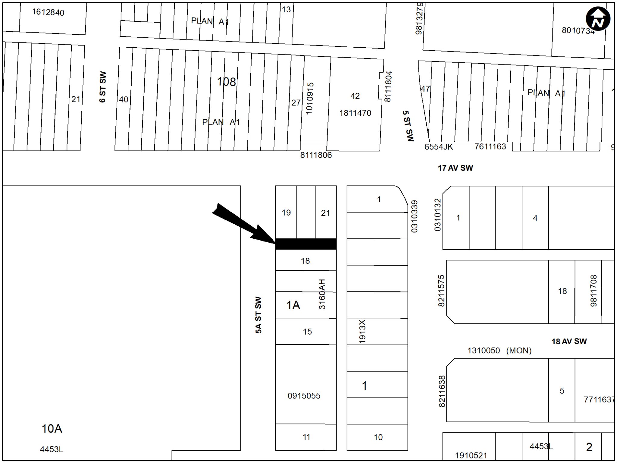
PLAN 1911117, AREA ‘A’
Policy Amendments
AMENDMENTS TO THE CLIFF BUNGALOW AREA REDEVELOPMENT PLAN
BYLAW 55P2022
The proposed amendments to the Cliff Bungalow Area Redevelopment Plan would change the land use policy for the site located at 1714, 1716, and 1718 – 5A Street SW and the adjacent right of way to the north from ‘Medium Density’ and road-right-of-way to ‘General Commercial’. This proposed policy amendment seeks to accommodate a mixed-use development and is in conjunction with the proposed road closure and land use redesignation for the site (Bylaws 8C2022 and 150D2022). For further information, please contact 403-268-5716.
Citywide
AMENDMENTS TO THE LAND USE BYLAW 1P2007
BYLAW 56P2022
This bylaw proposes amendments to Land Use Bylaw 1P2007 to:
1. Add the Housing – Grade-Oriented (H-GO) District. The H-GO District is a new housing district for Inner City. It would allow a range of grade-oriented housing. This District responds to the Motion Arising of 2022 April 12.
2. Amend the Residential – Grade-Oriented Infill (R-CG)(R-CGex) District by:
a. Adding the discretionary use of Townhouse to allow units that do not directly face the street and may be located at the rear of a parcel.
b. Allowing for buildings to be designed in different configurations. Should a second building be designed in the rear, there will be a maximum height of 8.6 metres for the rear building.
c. Requiring a minimum courtyard width of 6.5 metres.
d. Requiring a minimum parking requirement of 0.375 per unit and suite.
These amendments respond to the Motions Arising of 2021 September 13 and 2019 July 29.
3. Amend the General Rules of Multi-Residential Districts by:
a. Allowing suites within units that are not stacked.
b. Standardizing minimum parking requirements across districts.
For further information, please contact Michele Bussiere at michele.bussiere@calgary.ca
September 13 public hearing
Notice of Road Closures
The City of Calgary intends pursuant to s.22 of the Municipal Government Act to consider bylaws to close from use and sell or hold those portions of the streets, roads, lanes or public highways described here.
EAST VILLAGE
BYLAW 6C2022
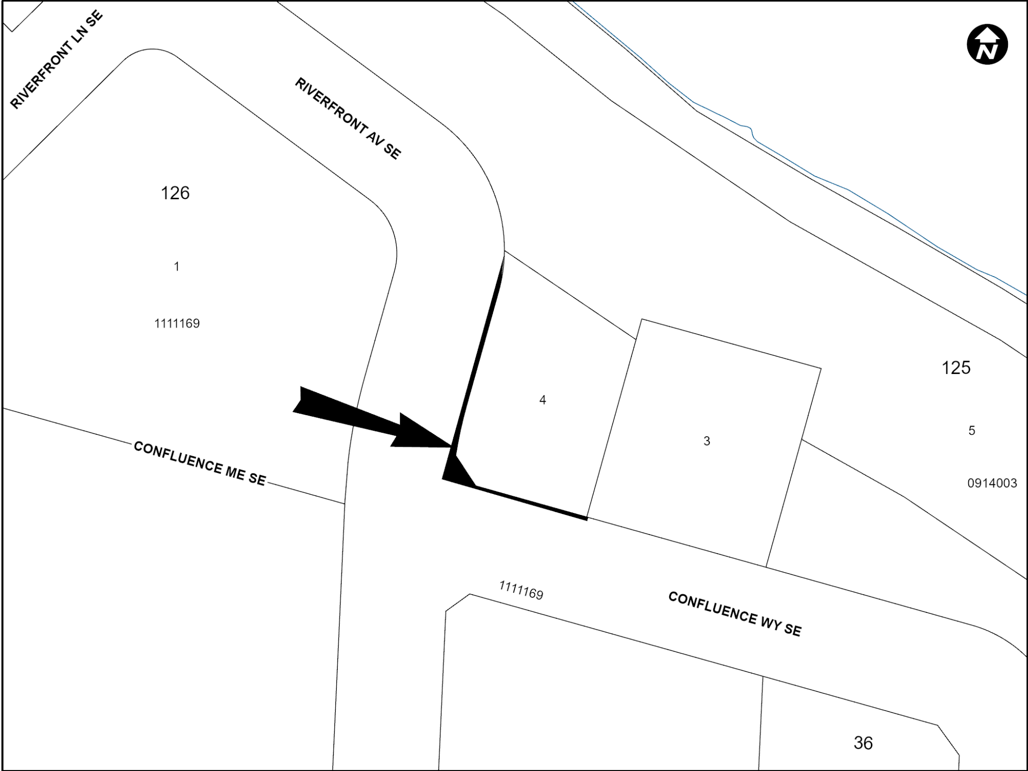
PLAN 2210832, AREA ‘A’
ASPEN WOODS
BYLAW 7C2022
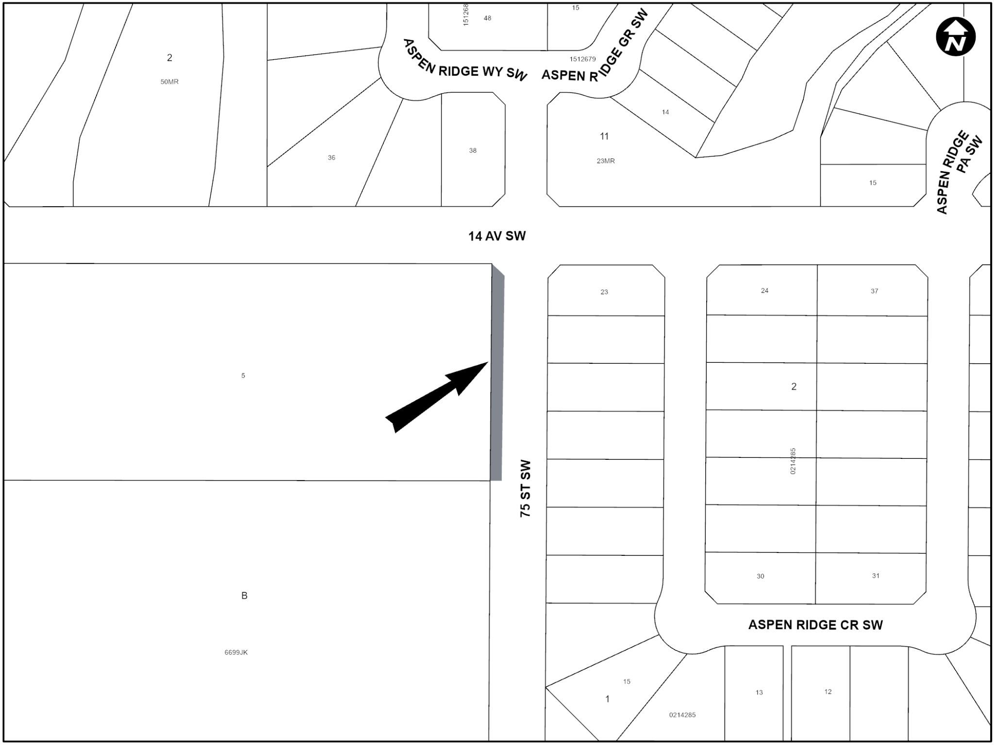
Plan 6699JK, Block B, Lot 5; Commencing at a point at the south east corner of Plan 6699JK, Block B, Lot 5, thence easterly extending the south boundary of said lot a distance of 4.12 metres. Thence northerly at a bearing parallel to the east boundary of said lot a distance of 72.72 metres. Thence north westerly to a point 1.00 metre south, along the east boundary of said lot, of the north east corner of said lot. Thence southerly, along the east boundary of said lot to the point of origin. Containing an area of 0.031 hectares ±
Transfer of Reserves
The City of Calgary intends pursuant to Section 676(1)(b) of the Municipal Government Act to consider a transfer of environmental reserve to the Crown or an agent of the Crown for consideration, as agreed, described here:
ALBERT PARK/RADISSON HEIGHTS
BYLAW 26M2022
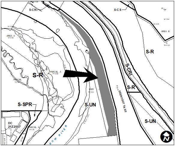
PORTION OF PLAN 7911222, BLOCK 10ER (Environmental Reserve) |
Land Use Redesignation
PARKDALE
BYLAW 133D2022
To redesignate the land located at 530 – 31 Street NW (Plan 8321AF, Block 37, Lots 30 and 31) from Residential – Contextual One / Two Dwelling (R-C2) District to Residential – Grade-Oriented Infill (R-CG) District.
WINSTON HEIGHTS/MOUNTVIEW
BYLAW 126D2022
To redesignate the land located at 604 – 33 Avenue NE (Plan 5942AD, Block 8, Lots 19 and 20) from Residential – Contextual One / Two Dwelling (R-C2) District to Residential – Grade-Oriented Infill (R-CG) District.
HIGHLAND PARK
BYLAW 127D2022
To redesignate the land located at 3424 Centre B Street NW (Plan 3674S, Block 3, Lots 22 and 23) from Residential – Contextual One / Two Dwelling (R-C2) District to Residential – Grade-Oriented Infill (R-CG) District.
HIGHLAND PARK
BYLAW 129D2022
To redesignate the land located at 3903 – 2 Street NW (Plan 3674S, Block 24, Lots 41 and 42) from Residential – Contextual One / Two Dwelling (R-C2) District to Residential – Grade-Oriented Infill (R-CG) District.
HIGHLAND PARK
BYLAW 130D2022
To redesignate the land located at 404 – 33 Avenue NW (Plan 3674S, Block 8, Lots 28 and 29) from Residential – Contextual One/Two Dwelling (R-C2) District to Residential – Grade-Oriented Infill (R-CGex) District.
HIGHLAND PARK
BYLAW 139D2022
To redesignate the land located at 116 – 43 Avenue NE (Plan 5988GT, Block 16, Lot 4) from the Residential – Contextual One / Two Dwelling (R-C2) District to Multi-Residential – Contextual Grade-Oriented (M-CGd75) District.
MOUNT PLEASANT
BYLAW 124D2022
To redesignate the land located at 3220 – 4 Street NW (Plan 9110053, Block 62, Lot 70) from Direct Control (DC) District to Commercial – Community 2 f1.0h12 (C-C2f1.0h12) District.
EAST VILLAGE
BYLAW 137D2022
To redesignate the closed road (Plan 2210832, Area ‘A’) adjacent to 606 Confluence Way SE from Undesignated Road Right-of-Way to Centre City East Village Mixed Use District (CC-EMU).
MONTGOMERY
BYLAW 120D2022
To redesignate the land located at 4519 – 21 Avenue NW (Plan 4994GI, Block 42, Lot 16) from Residential – Contextual One Dwelling (R-C1) District to Residential – Contextual One / Two Dwelling (R-C2) District.
MONTGOMERY
BYLAW 128D2022
To redesignate the land located at 5023 – 21 Avenue NW (Plan 4994GI, Block 37, Lot 17) from Residential – Contextual One Dwelling (R-C1) District to Residential – Contextual One / Two Dwelling (R-C2) District.
MONTGOMERY
BYLAW 131D2022
To redesignate the land located at 5011 – 22 Avenue NW (Plan 4994GI, Block 50, Lot 18) from Residential – Contextual One Dwelling (R-C1) District to Residential – Contextual One / Two Dwelling (R-C2) District.
MONTGOMERY
BYLAW 132D2022
To redesignate the land located at 5112 – 21 Avenue NW (Plan 4994GI, Block 50, Lot 9) from Residential – Contextual One Dwelling (R-C1) District to Residential – Contextual One / Two Dwelling (R-C2) District.
BOWNESS
BYLAW 134D2022
To redesignate the land located at 8345 – 34 Avenue NW (Plan 5960AM, Block 16, portion of Lot 10) from Residential – Contextual One Dwelling (R-C1) District to Residential – Contextual One / Two Dwelling (R-C2) District.
BOWNESS
BYLAW 135D2022
To redesignate the land located at 8507 – 34 Avenue NW (Plan 5960AM, Block 16, portion of Lot 5) from Residential – Contextual One Dwelling (R-C1) District to Residential – Contextual One / Two Dwelling (R-C2) District.
PANORAMA HILLS
BYLAW 125D2022
To redesignate the land located at 67 Panatella Square NW (Portion of SW 1/4 Section 34-25-1-5) from Special Purpose – Future Urban Development (S-FUD) District to Multi-Residential – Low Profile (M-1d85) District.
STONEY 1
BYLAW 142D2022
To redesignate the land located at 11105 and 11137 – 11 Street NE, 11134 – 15 Street NE, and 1117 – 110 Avenue NE (Plan 1911083, Block 4, Lots 10 and 11; Plan 1213696, Block 1, Lot 2; Plan 1213696, Block 4, Lot 2) from Industrial – Business (I-B) District and Direct Control (DC) District to Direct Control (DC) District to accommodate additional uses contained in other industrial districts.
BYLAW 143D2022
To redesignate the land located at 11061 and 10821 – 15 Street NE, and a portion of 10499 – 15 Street NE (Portion of E1/2 Section 23-25-1-5; Plan 0915074, OT) from Industrial – Business (I-B) District and Industrial – General (I-G) District to Direct Control (DC) District to accommodate additional uses contained in other industrial districts.
BYLAW 144D2022
To redesignate the land located at 11120 – 14 Street NE (Plan 1810369, Block 2, Lot 12) from Industrial – Business (I-B) District to Direct Control (DC) District to accommodate additional commercial uses.
FOREST LAWN
BYLAW 145D2022
To redesignate the land located at 1839 – 38 Street SE (Plan 2335AH, Block 19, Lots 1 and 2) from Multi-Residential – Contextual Low Profile (M-C1) District to Direct Control (DC) District to accommodate the additional use of rowhouse building.
BELTLINE
BYLAW 140D2022
To redesignate the land located at 1401 – 1 Street SE (Plan 0311438, Block 106, Lot 41) from Direct Control (DC) District to Direct Control (DC) District to accommodate additional uses within an existing building.
BRITANNIA
BYLAW 118D2022
To redesignate the land located at 4915 Elbow Drive SW (Plan 3700GO, Block 4, Lots 1 to 4) from Commercial – Corridor 1 f1.0h10 (C-COR1f1.0h10) District to Commercial – Corridor 1 f1.2h10 (C-COR1f1.2h10) District.
KILLARNEY/GLENGARRY
BYLAW 136D2022
To redesignate the land located at 2811 – 26 Street SW (Plan 5661O, Block 44, Lots 5 and 6) from Direct Control (DC) District to Residential – Contextual One / Two Dwelling (R-C2) District.
KILLARNEY/GLENGARRY
BYLAW 146D2022
To redesignate the land located at 2734 Richmond Road SW (Plan 5661O, Block 51, Lots 16 to 18) from Direct Control (DC) District to Direct Control (DC) District to accommodate the additional use of rowhouse building.
WILLOW PARK
BYLAW 119D2022
To redesignate the land located at 216 – 99 Avenue SE (Plan 3035JK, Block 11, Lot 42) from Residential – Contextual One Dwelling (R-C1) District to Residential – Contextual One / Two Dwelling (R-C2) District.
SHAWNESSY
BYLAW 121D2022
To redesignate the land located at 30 Shannon Place SW (Plan 8111812, Block 15, Lot 35) from Multi-Residential – Contextual Grade-Oriented (M-CGd44) District to Multi-Residential – Contextual Medium Profile (M-C2f1.2) District.
LEGACY
BYLAW 122D2022
To redesignate the land located at 21200 and 21415 – 24 Street SE, 22200 – 28 Street SE and 2501 and 2801 – 210 Avenue SE (Portion of Section 7-22-29-4; Portion of E1/2 Section 12-22-1-5; Portion of W1/2 Section 8-22-29-4; Portion of Plan 0910756, Area B; Portion of Plan 1311380, Area ‘D’) from Residential – One Dwelling (R-1s) District to Residential – Low Density Mixed Housing (R-G) District.
LEGACY
BYLAW 123D2022
To redesignate the land located at 250 and 280 Legacy Circle SE (Plan 1712147, Block 10, Lots 19 and 20) from Multi-Residential – Low Profile Support Commercial (M-X1) District to Residential – Low Density Mixed Housing (R-Gm) District.
MAHOGANY
BYLAW 138D2022
To redesignate the land located at 18007 – 88 Street SE and 18080 – 72 Street SE (Portion of N1/2 Section 23-22-29-4) from Residential – Low Density Mixed Housing (R-G) District, Multi-Residential – At Grade Housing (M-Gd50) District, Multi-Residential – Medium Profile (M-2d85) District, Multi-Residential – Medium Profile (M-2d100) District and Special Purpose – School, Park and Community Reserve (S-SPR) District to Residential – Low Density Mixed Housing (R-G) District and Special Purpose – School, Park and Community Reserve (S-SPR) District.
ASPEN WOODS
BYLAW 141D2022
To redesignate the land located at 7651 – 14 Avenue SW and the closed road (Plan 6699JK, Block B, Lot 5; Commencing at a point at the south east corner of Plan 6699JK, Block B, Lot 5, thence easterly extending the south boundary of said lot a distance of 4.12 metres. Thence northerly at a bearing parallel to the east boundary of said lot a distance of 72.72 metres. Thence north westerly to a point 1.00 metre south, along the east boundary of said lot, of the north east corner of said lot. Thence southerly, along the east boundary of said lot to the point of origin. Containing an area of 0.031 hectares ±) from Direct Control District and Undesignated Road Right-of-Way to Residential – One Dwelling (R-1s) District, Special Purpose – City and Regional Infrastructure (S-CRI) District and Special Purpose – School, Park and Community Reserve (S-SPR) District.
ASPEN WOODS
BYLAW 116D2022
To redesignate the land located at 7111 – 14 Avenue SW (Plan 9410843, Block A, Lot 13) from Direct Control (DC) District to Direct Control (DC) District to accommodate a multi-storey building.
Policy Amendments
AMENDMENT TO THE SPRINGBANK AREA STRUCTURE PLAN
BYLAW 43P2022
The proposed amendments would add site specific development guidelines within Section 2.2.3 Policies and replace subsection (a) within the East Springbank Area Structure Plan. The amendments are being proposed to allow for a 5-storey multi-storey development at 7111 – 14 Avenue SW. This proposed policy amendment is in conjunction with the proposed land use redesignation for the site (Bylaw 116D2022). For further information, please contact 403-268-5344.
AMENDMENTS TO THE MONTGOMERY AREA REDEVELOPMENT PLAN
BYLAW 45P2022
The proposed amendments to the Montgomery Area Redevelopment Plan would change the land use policy for the site located at 4519 – 21 Avenue NW to exempt the site from the restrictions on land use redesignations. This proposed policy amendment is in conjunction with the proposed land use redesignation for the site (Bylaw 120D2022). For further information, please contact 587-576-4317.
AMENDMENTS TO THE MONTGOMERY AREA REDEVELOPMENT PLAN
BYLAW 46P2022
The proposed amendments to the Montgomery Area Redevelopment Plan would change the land use policy for the site located at 5023 – 21 Avenue NW to exempt the site from the restrictions on land use redesignations. This proposed policy amendment is in conjunction with the proposed land use redesignation for the site (Bylaw 128D2022). For further information, please contact 403-312-5474.
AMENDMENTS TO THE MONTGOMERY AREA REDEVELOPMENT PLAN
BYLAW 47P2022
The proposed amendments to the Montgomery Area Redevelopment Plan would change the land use policy for the site located at 5011 – 22 Avenue NW to exempt the site from the restrictions on land use redesignations. This proposed policy amendment is in conjunction with the proposed land use redesignation for the site (Bylaw 131D2022). For further information, please contact 587-576-3085.
AMENDMENTS TO THE MONTGOMERY AREA REDEVELOPMENT PLAN
BYLAW 48P2022
The proposed amendments to the Montgomery Area Redevelopment Plan would change the land use policy for the site located at 5112 – 21 Avenue NW to exempt the site from the restrictions on land use redesignations. This proposed policy amendment is in conjunction with the proposed land use redesignation for the site (Bylaw 132D2022). For further information, please contact 403-369-6488.
AMENDMENT TO THE KILLARNEY / GLENGARRY AREA REDEVELOPMENT PLAN
BYLAW 49P2022
The proposed amendment to the Killarney/Glengarry Area Redevelopment Plan would change the land use policy for the site located at 2734 Richmond Road SW from Conservation/ Infill to Low Density Townhousing. This proposed policy amendment is in conjunction with the proposed land use redesignation for the site (Bylaw 146D2022). For further information, please contact 403-305-0297.
AMENDMENT TO THE KEYSTONE AREA STRUCTURE PLAN
BYLAW 50P2022
A policy amendment is proposed to the Keystone Hills Area Structure Plan to remove Growth Management Overlay for several parcels. This amendment includes replacing the existing Map 4 entitled “Growth Management Overlay” with an updated Map 4 entitled “Growth Management Overlay” that includes a larger Growth Management Overlay Removal Area. For further information, please contact 587-572-7462.
AMENDMENT TO THE BELVEDERE AREA STRUCTURE PLAN
BYLAW 51P2022
A policy amendment is proposed to the Belvedere Area Structure Plan to remove Growth Management Overlay for several parcels. This amendment includes replacing the existing Map 4 entitled “Growth Management Overlay” with an updated Map 4 entitled “Growth Management Overlay” that includes a larger Growth Management Overlay Removed Area. For further information, please contact 587-572-7462.
AMENDMENT TO THE RICARDO RANCH AREA STRUCTURE PLAN
BYLAW 52P2022
A policy amendment is proposed to the Ricardo Ranch Area Structure Plan to remove Growth Management Overlay for the entire area. This amendment includes replacing the existing Map 12 entitled “Growth Management Overlay” with an updated Map 12 entitled “Growth Management Overlay” that includes the entire area within the Growth Management Overlay Removal Area. For further information, please contact 587-572-7462.
July 26 public hearing
Land Use Redesignation
RENFREW
BYLAW 108D2022
To redesignate the land located at 424 and 428 – 13 Avenue NE (Plan 791P, Block 40, Lots 11 to 13 and a portion of Lot 10) from Residential – Contextual One / Two Dwelling (R-C2) District to Residential – Grade- Oriented Infill (R-CG) District.
KILLARNEY / GLENGARRY
BYLAW 109D2022
To redesignate the land located at 3602 – 21 Avenue SW (Plan 6000AG, Block 6F, Lots 1 and 2) from Residential – Contextual One / Two Dwelling (R-C2) District to Residential – Grade-Oriented Infill (R-CG) District.
ROSSCARROCK
BYLAW 106D2022
To redesignate the land located at 933 – 38 Street SW (Plan 3681V, Block 2, Lots 15 to 17) from Multi-Residential – Contextual Low Profile (M-C1) District to Direct Control (DC) District to accommodate a rowhouse development.
BANKVIEW
BYLAW 111D2022
To redesignate the land located at 2101 – 17A Street SW (Plan 3076AB,
Block 7, Lots 1 and 2) from Residential – Contextual One / Two Dwelling
(R-C2) District to Multi-Residential – Contextual Grade-Oriented (M-CG)
District.
ALTADORE
YLAW 115D2022
To redesignate the land located at 1603 – 38 Avenue SW (Plan 4890AG, Block A, Lots 25 and 26) from Residential – Grade-Oriented Infill (R-CG) District to Direct Control (DC) District to accommodate a rowhouse building.
ERLTON
BYLAW 114D2022
To redesignate the land located at 29, 33 and 37 – 25 Avenue SW (Plan 2865AC, Block 1, Lots 9 to14) from Residential – Contextual One / Two Dwelling (R-C2) District to Multi-Residential – Low Profile Support Commercial (M-X1) District.
SOUTHVIEW
BYLAW 113D2022
To redesignate the land located at 2531 – 36 Street SE (Plan 2866GT, Block 4, Lot 17) from Residential – Contextual One Dwelling (R-C1) District to Commercial – Neighbourhood 1 (C-N1) District.
INGLEWOOD
BYLAW 107D2022
To redesignate the land located at 2003 – 16 Street SE (Plan 9311097, Block 12, Lot 1) from Multi-Residential – Contextual Grade-Oriented (M-CGd30) District to Multi-Residential – Contextual Grade-Oriented (M-CGd33) District.
CAPITOL HILL
BYLAW 105D2022
To redesignate the land located at 1502 and 1508 – 22 Avenue NW (Plan 2864AF, Block 7, Lots 1 to 4) from Residential – Contextual One / Two Dwelling (R-C2) District to Multi-Residential – Contextual Low Profile (M-C1) District.
ASPEN WOODS
BYLAW 116D2022
To redesignate the land located at 7111 – 14 Avenue SW (Plan 9410843, Block A, Lot 13) from Direct Control (DC) District to Direct Control (DC) District to accommodate a multi-storey building.
ASPEN WOODS
BYLAW 117D2022
To redesignate the land located at 1459 – 69 Street SW (Plan 1144AC, Block A, Lot 7) from Direct Control (DC) District to Residential – Low Density Mixed Housing (R-G) District and Special Purpose – School, Park and Community Reserve (S-SPR) District.
FAIRVIEW INDUSTRIAL
BYLAW 112D2022
To redesignate the land located at 510 – 77 Avenue SE (Plan 2175JK, Block 1) from Commercial – Corridor 3 f1.0h12 (C-COR3 f1.0h12) District to Direct Control (DC) District to accommodate the additional use of School – Private.
BELMONT
BYLAW 110D2022
To redesignate the land located at 150 Belmont Street SW (Plan 1912050, Block 9, Lot 2) from Residential – Low Density Multiple Dwelling (R-2M) District to Multi-Residential – At Grade Housing (M-G) District.
Policy Amendments
AMENDMENT TO THE KILLARNEY / GLENGARRY AREA REDEVELOPMENT PLAN
BYLAW 38P2022
The proposed amendment to the Killarney/Glengarry Area Redevelopment Plan would change the land use policy for the site located at 3602 – 21 Avenue SW from “Conservation/ Infill” to “Low Density Townhousing”. This proposed policy amendment is in conjunction with the proposed land use redesignation for the site (Bylaw 109D2022). For further information, please contact 403-312-7897.
AMENDMENT TO THE BANKVIEW AREA REDEVELOPMENT PLAN
BYLAW 39P2022
The proposed amendment to the Bankview Area Redevelopment Plan would change the land use policy for the site located at 2101 – 17A Street SW from ‘Conservation’ to ‘Medium Low Density’. This proposed policy amendment is in conjunction with the proposed land use redesignation for the site (Bylaw 111D2022). For further information, please contact 403-816-2735.
AMENDMENT TO THE ERLTON AREA REDEVELOPMENT PLAN
BYLAW 40P2022
The proposed amendments to the Erlton Area Redevelopment Plan are to add a new land use classification, add an additional row to the table ‘Land Use Recommendations’, and replace the existing Map 2 within the Erlton Area Redevelopment Plan. These amendments are being proposed to allow for three adjoining parcels to be developed into a mixed-use redevelopment. The amendment to the Area Redevelopment Plan would change the land use classification for the subject parcels from ‘Low Density Residential’ to ‘Low to Medium Density Mixed Use’. This proposed policy amendment is in conjunction with the proposed land use redesignation for the site (Bylaw 114D2022). For further information, please contact 403-669-8595.
AMENDMENT TO THE MISSION AREA REDEVELOPMENT PLAN
BYLAW 41P2022
The proposed amendment to the Mission Area Redevelopment Plan would increase the maximum residential density allowed at 211 – 25 Avenue SW which would align with the existing land use district and the Municipal Development Plan. For further information, please contact 587-576-4310.
AMENDMENT TO THE SOUTH CALGARY/ALTADORE AREA REDEVELOPMENT
PLAN
BYLAW 42P2022
The proposed amendment to the South Calgary/Altadore Area Redevelopment Plan would change the land use policy for the site located at 1603 – 38 Avenue SW from ‘Residential Low Density’ to ‘Residential Medium Density’. This proposed policy amendment is in conjunction with the proposed land use redesignation for the site (Bylaw 115D2022). For further information, please contact 403-510-6769.
AMENDMENTS TO THE LAND USE BYLAW 1P2007
BYLAW 44P2022
Amendments to the industrial sections of the Land Use Bylaw are proposed that support growth in Calgary’s industrial sector by resolving immediate issues and barriers to development. These amendments:
- Introduce new defined terms and uses to better manage waste facilities and better enable recycling operations.
- Consolidate storage type land uses.
- Streamline process requirements for applications on major streets and expressways in the Industrial-General Districtand permitted uses across industrial districts.
- Increase the building height in the Industrial – General District.
- Add the General Industrial – Light use to the Industrial – Business District and the Vehicle Rental – Minor use in Industrial – General and Industrial – Redevelopment Districts.
- Include housekeeping to clarify between Provincial regulations for cannabis sales and the Education Act, and the defined use of Child Care Services in the Land Use Bylaw that may include a kindergarten.
For more information, please contact John Manieri at: John.Manieri@calgary.ca.
June 7 public hearing
Notice of Road Closures
The City of Calgary intends pursuant to s.22 of the Municipal Government Act to consider bylaws to close from use and sell or hold those portions of the streets, roads, lanes or public highways described here.
SPRUCE CLIFF BYLAW 4C2022
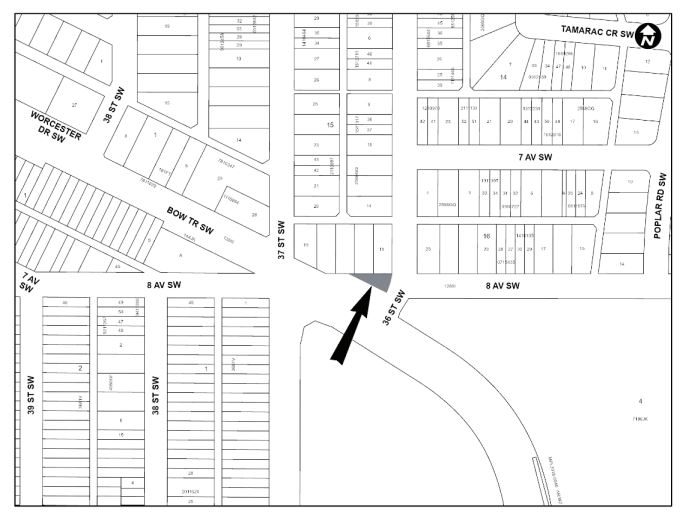
PLAN 2210415, AREA ‘A’
Disposition of Reserves
The City of Calgary intends pursuant to Section 674 of the Municipal Government Act to consider resolutions to sell, lease, or otherwise dispose of reserve lands described here
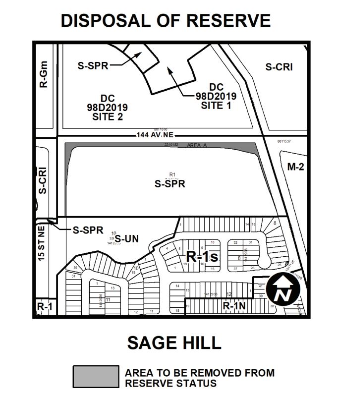
SPRUCE CLIFF BYLAW 4C2022
PLAN 2210182, AREA A
Land Use Redesignation
KILLARNEY / GLENGARRY
BYLAW 76D2022
To redesignate the land located at 3216 – 26 Avenue SW (Plan 1855W, Block 3B, Lots 39 and 40) from Residential – Contextual One / Two Dwelling (R-C2) District to Residential – Grade-Oriented Infill (R-CG) District.
BOWNESS
BYLAW 77D2022
To redesignate the land located at 8103 – 47 Avenue NW (Plan 2660AP, Block 8, Lot 2) from Residential – Contextual One / Two Dwelling (R-C2) District to Residential – Grade-Oriented Infill (R-CG) District.
BOWNESS
BYLAW 78D2022
To redesignate the land located at 8340 – 47 Avenue NW (Plan 2660AP, Block 2, Lot 22) from Residential – Contextual One Dwelling (R-C1) District to Residential – Contextual One / Two Dwelling (R-C2) District.
SOUTH CALGARY
BYLAW 79D2022
To redesignate the land located at 1923 – 26 Avenue SW (Plan 4479P, Block 5, Lots 29 and 30) from Residential – Contextual One / Two Dwelling (R-C2) District to Multi-Residential – Contextual Grade-Oriented (M-CGd75) District.
CRESCENT HEIGHTS
BYLAW 80D2022
To redesignate the land located at 122 – 12 Avenue NW (Plan 3946N, Block 7, Lots 25 to 28) from Multi-Residential – Contextual Low Profi le (M-C1) District to Multi-Residential – Contextual Medium Profi le (M-C2d155) District.
INGLEWOOD
BYLAW 81D2022
To redesignate the land located at 1420 – 15 Street SE (Plan 5596L, Block B, Lots 5 and 6) from Residential – Contextual One / Two Dwelling (R-C2) District to Residential – Grade-Oriented Infill (R-CG) District.
BRIDGELAND/RIVERSIDE
BYLAW 82D2022
To redesignate the land located at 525 – 9 Street NE (Plan 4647V, Block 121, Lot 8) from Residential – Contextual One / Two Dwelling (R-C2) District to Residential – Grade-Oriented Infill (R-CG) District.
THORNCLIFFE
BYLAW 83D2021
To redesignate the land located at 5416 Centre A Street NE, (Plan 1495HB, Block 1, Lot 6) from Residential – Contextual One Dwelling (R-C1) District to Residential – Contextual One / Two Dwelling (R-C2) District.
SPRUCE CLIFF
BYLAW 84D2021
To redesignate the land located at 716 - 37 Street SW and the closed road located adjacent to 3704, 3708 and 3712 – 8 Avenue SW (Plan 2566GQ, Block 15, Lot 19; Plan 2210415, Area ‘A’) from Residential – Contextual One / Two Dwelling (R-C2) District and Undesignated Road Right-of-Way to Mixed Use – General (MU-1f3.0h22) District.
SAGE HILL
BYLAW 85D2021
To redesignate the land located at 30 Sage Hill Row NW (Plan 2111238, Block 6, Lot 2) from Multi-Residential – Medium Profi le (M-2) District to Multi-Residential – High Density Low Rise (M-H1) District.
Policy Amendments
AMENDMENTS TO THE KILLARNEY / GLENGARRY AREA REDEVELOPMENT PLAN BYLAW 30P2022
The proposed amendment to the Killarney/Glengarry Area Redevelopment Plan would change the land use policy for the site located at 3216 – 26 Avenue SW from Conservation Infill to Low Density Townhousing. This proposed policy amendment is in conjunction with the proposed land use redesignation for the site (Bylaw 76D2022). For further information, please contact 403-268-5603.
AMENDMENTS TO THE BANKVIEW AREA REDEVELOPMENT PLAN BYLAW 31P2022
This proposal is to amend the Bankview Area Redevelopment Plan in order to accommodate multi-residential development at 1923 – 26 Avenue SW. The amendment will change the property’s land use category from ‘Conservation’ to ‘Conservation and Infi ll’ to allow an increase in density and change in built form. This amendment is associated with the proposed land use redesignation for the site (Bylaw 79D2022). For further information, please contact 587-576-4314.
AMENDMENTS TO THE BRIDGELAND-RIVERSIDE AREA REDEVELOPMENT PLAN BYLAW 32P2022
The proposed amendment to the Bridgeland-Riverside Area Redevelopment Plan would change the land use policy for the site located at 525 – 9 Street NE to allow for low density multi-residential development. This proposed policy amendment is in conjunction with the proposed land use redesignation for the site (Bylaw 82D2022). For further information, please contact 403-512-6405.
AMENDMENTS TO THE MONTGOMERY AREA REDEVELOPMENT PLAN BYLAW 33P2022
The proposed amendment to the Montgomery Area Redevelopment Plan would change the land use policy for the
site located at 5232 – 21 Avenue NW to exempt the site from the restrictions on land use redesignations. This proposed policy amendment is in conjunction with the proposed land use redesignation for the site (Bylaw 93D2022). For further information, please contact 403-268-4967.
AMENDMENTS TO THE LAND USE BYLAW 1P2007 BYLAW 34P2022
In conjunction with proposed amendments to the City’s Community Standards Bylaw 32M2023, this bylaw proposes amendments to Land Use Bylaw 1P2007 to shift the enforcement of vehicle parking in the front yard of residential properties to Bylaw Officers in Calgary Community Standards. The Bylaws will come into eff ect August 15, 2022. For further information, please contact Tammy Henry at: Tammy.Henry@Calgary.ca.
Development map
Use developmentmap.calgary.ca, or click the addresses in the advertised planning matters below. to learn more about planning applications, what is being proposed, understand the details and know when and what you can comment on.
Our terms for public hearings on planning matters
Addressing Council at a Public Hearing
Any person who wishes to address Council on any matter mentioned herein may do so for a period of FIVE MINUTES. A speaker cannot transfer any of their speaking time to another speaker. Persons addressing Council shall limit their comments to the matter contained in the report and the recommendations being discussed.
Anyone wishing to distribute additional written materials at the meeting shall submit the material to the City Clerk’s Office, on the online Public Submission Form. Please submit presentations materials in PDF format. The City Clerk's Office will not accept materials in USB drives. Please do not add links to your written or audio-visual materials. It should be noted that such additional material will require the consent of the Mayor before distribution to Members of Council. Audio-visual submissions must be received by the City Clerk’s Office no later than 12:00 p.m. (noon) eight days before the meeting. The City Clerk’s Office will not accept late audio-visual submissions.
If the Public Hearing is still in progress at 9:30 p.m., Council may conclude the matter under discussion and will reconvene at 1:00 p.m. of the next business day, unless otherwise directed by Council.
Providing comments
Written and audio-visual submissions about a Public Hearing item must be received no later than 12:00 p.m. (noon) eight days before the meeting. Late submissions will not be accepted in the City Clerk’s Office. Submissions that include personal information of third parties not being represented by the member of the public may be redacted or not included in the Agenda.
Audio-visual submissions must not exceed five minutes in length, must be provided to the City Clerk’s Office electronically, and must be presented by the submitter at the meeting for which they have been submitted.
Submissions may be provided to the City Clerk’s Office through the online Public Submission Form.
Collection Notice:
Personal information is collected for the purpose of public participation in municipal decision-making by Council and Council Committees and scheduling speakers for Council or Council Committee meetings. Your personal information may also be used by an automated system to generate content. This collection is authorized under Procedure Bylaw 42M2025, and Section 216.4 of the Municipal Government Act and Sections 4(a) and (c) of the Protection of Privacy Act of Alberta.
Reminder:
Public Meetings are broadcast live and recorded for future public viewing.
By entering the Council Chamber or by speaking at a meeting of Council or a Council Committee, you are consenting to The City of Calgary using, disclosing and retaining your name, image, and comments.
If you speak at a meeting of Council or a Council Committee, your name will appear in the meeting minutes, which are retained as a permanent public record. Your name, image and/or comments may be made publicly available in the live video broadcast and recordings of meetings that are publicly accessible on Council and committee agendas, minutes and video.
The use, disclosure and retention of your personal information is for the purposes established by the Procedure Bylaw 42M2025, and Section 216.4 of the Municipal Government Act of Alberta.
If you have questions regarding the collection and use of your personal information, please contact: City Clerk’s Office, Legislative Services, 403-268-5861, or 700 Macleod Trail S.E., P.O. Box 2100, Station M (MC 8007), Calgary, Alberta, T2P 2M5.
Advertised Planning Items
A copy of the proposed bylaws and documents relating to these items are available above. The information available on the website is not provided as an official record but is made available online as a public service for the public’s convenience. The City of Calgary assumes no liability for any inaccurate, delayed or incomplete information provided on the website. In case of any discrepancies between the documents and materials on this website and the official documents and materials at the Office of the City Clerk, the official documents and materials at the Office of the City Clerk shall prevail. Please contact 403-268-5311 as soon as possible if you notice any errors or omissions in the documents and materials
The uses and rules that apply to different land use designations are found in the Land Use Bylaw 1P2007 calgary.ca/landusebylaw except those for the DC District which are available from Planning & Development. Please direct questions with regard to the matters mentioned herein to 403-268-5311.