10 Street Gravel Bar & Recreational Wave
Project background
Over the past several decades, a gravel bar has been forming in the Bow River under the Louise Bridge that connects 10 Street N.W. to downtown. Since the 2013 flood in Calgary, the 10 Street Gravel Bar under the bridge has grown in size, increasing flood risk to neighbouring communities. This project explores solutions to modify the gravel bar to reduce future risk, at the same exploring opportunities to enhance fish habitat, protect infrastructure from bank erosion and create recreational opportunities in this reach of the river. Since 2013, the Sunnyside Flood Barrier and Downtown Flood Barrier have also been completed to reduce flood risk in this area.
Gravel bars form naturally in rivers from sediment movement. They become a concern when they form in and around bridges and constrict flow of the river.
- The 2013 flood resulted in a dramatic increase in size of the gravel bar.
- Since 2013, the gravel bar has become covered with plants including poplar trees which are expected to continue growing in size which will further contribute to the bar's impacts.
The primary purpose of this project is to mitigate flood risk, while exploring the best possible configuration of the gravel bar for future river safety, recreation, and accessibility.
The aerial images below show the gravel bar’s increase in size after the 2013 flood. The green dashed line indicates the riverbanks before the flood, and the purple dashed line indicates the banks after the flood.
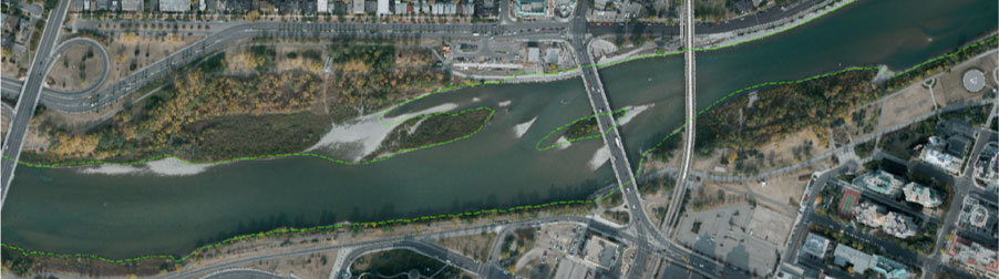
Aerial image of project area in 2012 (before flood)
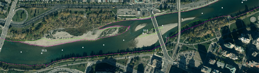
Aerial image of project area in 2014 (after flood)
The continued growth of the bar and its plants increases the flood risk to the surrounding area, by blocking water flow through the bridge.
- This increases water levels upstream that can increase the flood and groundwater levels in the adjacent neighborhoods.
- It also causes erosion along the opposite bank and bed of the river which can put infrastructure, including bridges, outfalls, and pathways at risk.
Gravel bar realignment
We are assessing lowering flood risk by realigning the gravel bar. This means that the gravel and soil would be removed and redistributed within nearby areas of the river using a nature based approach.
- Realignment of the gravel bar would provide long-term flood mitigation benefits and be the most environmentally beneficial and stable solution.
- It will also improve fish and riparian habitat in the area and naturalize the south bank by redistributing the removed materials.

Recreational wave
Since 2013, there has been a natural standing wave in the river adjacent to the gravel bar which has been used for recreation such as river surfing.
- This wave has been decreasing in quality as natural sediment movement continues to occur and the gravel bar increases in size.
- The area is hazardous for river rafters and floaters since they need to navigate around the gravel bar and can get stuck on the boulders and wood debris where the river turns after the bridge.
- Realigning the gravel bar would result in safer navigation for river users.
Studies to date have not identified any significant technical, regulatory, or safety reasons to exclude further exploration of a recreational wave. From a technical perspective, this location could support a wave feature due to the hydraulic and geotechnical conditions. Based on this, detailed design of the recreational wave will move forward, however its approval and construction is still dependent on several factors including funding, regulatory approvals, and operational viability.
River waves have been constructed in other municipalities such as:
- The Bend White Water Park in Bend, Oregon;
- The Boise White Water Park in Boise, Idaho
- The Eisbachwelle Wave Park in Munich, Germany
Technical Background
River engineering of the project has included research partnerships with both the University of Ottawa and the National Research Council of Canada (NRC). Through these partnerships a physical scale model of the proposed gravel bar realignment was constructed to confirm the performance of the proposed nature-based solution.
Findings and lessons from this work were integrated into the project design. This work was partly funded by the NRC’s Climate Resilient Built Environment Initiative, in support of delivering the Government of Canada’s Adaptation Action Plan, and towards achieving commitments under the National Adaptation Strategy.

Adjacent Projects
The 10 Street Gravel Bar project is occurring in parallel with several other City projects and initiatives that are envisioned to work in coordination with one another to deliver their mandates. These include:
RiverWalk West
Calgary’s Downtown Strategy
Harvie Passage
Sunnyside Flood Barrier
Next steps
We are currently in the Detailed Design phase. Approval to proceed to construction will be determined as we move further along in the design process, and will be dependent on funding and regulatory approvals. Please check this page for updates.
Timeline
- Detailed Design – October 2025 to October 2026
- Project Budget Approval Decision – after Detailed Design
- Regulatory approvals November 2026 - November 2027 (tentative)
- Construction – Schedule to be determined (tentative)
Document links
- 10th Street Recreational Wave Viability Summary Report
- 10th St Gravel Bar and Recreational Wave Preliminary Design Report
- Appendix A - BIA Draft
- Appendix B - Habitat Restoration Approach Draft
- Appendix C - Preliminary Hydrotechnical Design Report
- Appendix D - NRC Physical Model Study
- Appendix E - Adjustable Waves Preliminary Design Report
- Appendix F - Preliminary Landscape Architecture Design Report
- Appendix G - Preliminary Design Cost Estimate
- Appendix H - Recreational Wave Viability Report
- Appendix I - Land Ownership and Utilities Technical Memo
- Appendix J - Existing Uses Technical Memo
- Appendix K - Tree Survey Technical Memo
- Appendix L - Literature and-Data Review Memo
Budget
The estimated cost for this project is $12 million.
Stay Connected
Sign up to receive email updates about this project.
For more information or questions, please email the project team at 10stgravelbar@calgary.ca