Community Flood Barriers - studies and reports
Bowness feasibility studies (2018-2020)
Studies were conducted over 18 months to explore the feasibility of a flood barrier from the early conceptual design.
River modelling
Prepared by: KCB Engineering
This study helped us predict how the Bow River behaves at the design flow rate of 1,230 m3/s. The results from the computer river model was used to:
- Determine the barrier height
- Understand how the river affects groundwater
- Understand how the river interacts with the stormwater system
- Understand whether a barrier would affect neighbouring communities
The study results showed the optimal alignment to protect the greatest number of properties in Bowness was along the riverfront targeting two key low-lying areas on the north and south ends of Bow Crescent. These areas were identified to be the source of overland flooding in the community and that a flood barrier could effectively stop water from overflowing the riverbanks. The recommended barrier heights vary from 0.4 to 1.7 metres, depending on the location on the property.
Results of how the river influences groundwater and interacts with the stormwater system are detailed in the separate groundwater and stormwater studies.
Please note: Reports can be downloaded using Microsoft Edge, Internet Explorer and Firefox, but not in the newest versions of Chrome.
Groundwater studies
Prepared by: KCB Engineering
We follow a consistent design process for all flood mitigation projects. We conduct studies to understand the existing groundwater conditions and determine how they could change if a flood barrier is constructed.
What did we do?
- We conducted groundwater monitoring and pumping tests to understand how changes in the river level may affect how fast and how high groundwater levels rise in Bowness.
- How quickly and in which direction(s) water may flow underground.
- Geophysical studies to understand the geology of the area in greater detail.
- Groundwater chemistry to interpret groundwater flow patterns, before and after peak river flows were observed on the Bow River.
Results and findings
What are the existing groundwater conditions in the area?
Groundwater conditions are similar to other riverside communities
Bowness was built on a highly permeable aquifer, like downtown and Sunnyside. This means water can travel more easily in some of the geological layers under the ground surface.
The groundwater flow changes direction during the year
For most of the year, groundwater travels down from the Paskapoo slopes and out towards the river. Maintaining this unobstructed path for the groundwater to exit is important to prevent the groundwater table from rising.
During the spring high water season, the flow reverses direction and groundwater flows from the river into the soil.
What is the effect on groundwater when overland river flow is blocked by a barrier?
- Slightly lower groundwater table. Study results showed that removing overland flow typically resulted in lowering of the groundwater table, on average by 0.4 m.
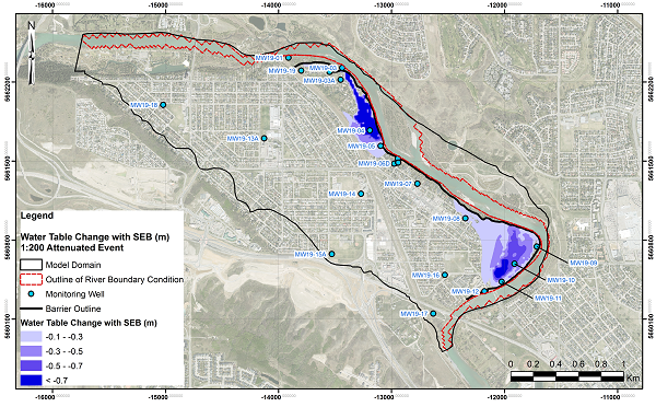
Figure ES.4 Peak Water Table Reduction with Surface Barrier, 1:200 Attenuated Event
- Localized pockets of groundwater may come to the surface, but it can be addressed by pumping wells. Our studies showed that when the overland flow is held back by a barrier during a flood, we may still see localized pockets of groundwater coming to the surface in small areas. The number and placement of pumping wells would be determined in subsequent design phase, if the barrier was considered feasible.
Groundwater levels with and without a surface barrier in place are shown below:
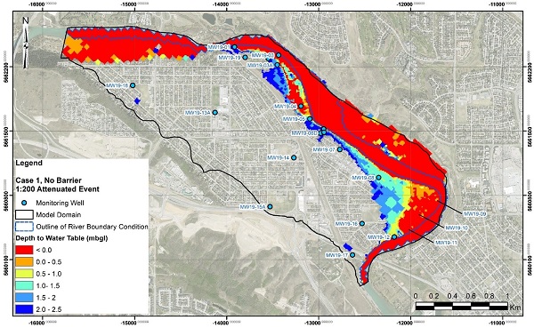
Figure ES.2 Depth to Peak Water Table, no mitigation, 1:200 Attenuated Event
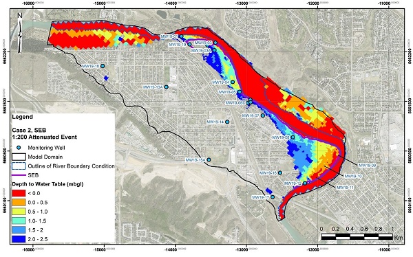
Figure ES.3 Depth to Peak Water Table with Surface Barrier, 1:200 Attenuated Event
Full Report and appendices
Due to large file sizes, PDFs may take a few minutes to download and are best viewed on desktop.
- Hydrogeological Characterization and Groundwater Flow Modelling Report – May 2021
- Appendix I: Hydrogeological Site Investigation and Groundwater Monitoring Summary Report
- Appendix I4: Tetra Tech Geophysical Investigation Report
- Appendix II: Alberta Water Well Records
- Appendix III: Groundwater Model Design Basis Memorandum
- Appendix IV: Numerical Groundwater Model – Calibration
- Appendix V: Numerical Groundwater Model – Groundwater Flood Mitigation Simulations
- Table of Changes
Third Party Review of Groundwater Study
The City hired an independent third party reviewer for the geotechnical and hydrological studies in Bowness based on feedback from the community. This review helps ensure the studies meet standards, are comprehensive and that their interpretation of the findings are consistent with those of Klohn Crippen Berger (KCB), who conducted the study. Their letters below are a summary of their review:
Recommendations
As with all riverside communities in Calgary, managing the risk of basement flooding can be best achieved through a combined approach – controlling the river flow through upstream reservoirs to keep groundwater levels low; community flood barriers to prevent community flooding; property-level flood protection to limit risk exposure.
When river flows cannot be maintained below basement levels, or when the water table rises due to heavy rainfall, an effective way to help reduce basement flood risk is by taking the appropriate steps at home. This includes:
- Install a sump pump with a back-up power source.
- Install sanitary sewer backflow preventer valves.
- Ensure downspouts drain onto the ground at least two metres away from your home.
- Improve your lot grading so that it slopes away from the house foundation.
- Repair cracks in the basement foundation.
- Finish basements with easily washable materials, such as concrete floors and walls.
- Install water alarms in the basement to alert you if water is backing up.
- Avoid building living spaces below grade.
Stormwater studies
Prepared by: Matrix Solutions
This study was used to determine the potential impacts a permanent overland flood barrier would have on existing drainage infrastructure. Using a comprehensive computer model allowed us to compare existing (no-barrier) conditions to a scenario with a riverfront flood barrier to determine how stormwater drainage changes can be managed.
The study results revealed that some modifications to the stormwater system in Bowness would be needed if a permanent overland flood barrier was built. The study identified which outfall gates would need to be closed during a flood event and what infrastructure (e.g. pumps) would be needed to manage drainage while the gates were closed. The study recommended using temporary pumps only deployed during emergency events in lieu of permanent infrastructure. The study also identified that some lots will require a change to their local drainage to ensure stormwater does not build up on their property with the barrier in place. Site-specific solutions would be explored further as part of a potential future phase of design.
During a flood, who is responsible for the closure of stormwater outfall gates?
During a flood, The City would follow its Emergency Response Plan which includes the closure of outfall gates. The Emergency Response Plan would also cover deployment of temporary pumps to ensure stormwater does not back up behind the barrier.
How was groundwater considered? How are sump pumps considered?
The groundwater infiltration into the storm system, whether through cracks in pipes and manholes, leaky pipe joints and connections, and weeper holes, is expected to be a small fraction (1-2%) of the potential flows in the storm pipes. For more information, refer to Section 2.6 of the Stormwater Assessment and Mitigation Report.
Environmental review
Prepared by: KCB Engineering
In this phase, the purpose of the environmental review was to get a baseline understanding of the environmental conditions in Bowness by building an inventory of what exists (e.g. amphibians, birds, vegetation, rare plants and wetlands, soils, fish and fish habitats). Independent biologists captured feedback provided by residents and also visited the area throughout various times in the year to observe and note the wildlife.
If the project were to proceed to the next phase, a full environmental impact assessment would be completed once an alignment was confirmed. This final assessment would provide information on potential impacts to existing habitat features, fish, wildlife and vegetation and how to mitigate them during construction.
Conceptual studies (2013-2018)
These studies identified a flood barrier as an option to help mitigate overland flooding in Bowness. As work on exploring the feasibility of a permanent flood barrier continues, information on properties and technical data will be gathered. Project limitations and options will also be identified.
Permanent Flood Barrier Protection Assessment
Prepared by: Associated Engineering
The City of Calgary requested a study into whether flood barriers may be an effective solution to reduce flood risk in our city. The Study used a Triple Bottom Line (TBL) approach to evaluate the social, environmental and economic costs and benefits, using a specific process built for this study. The costs and benefits assessed barrier protection at various heights for many communities. Information from this study was included in our city-wide Flood Mitigation Measures Assessment.
Please note: Associated Engineering created conceptual designs for community-level flood barriers to help calculate rough costs and benefits, and to see if barriers in these general locations were technically feasible.
It’s important to note that height, location on individual properties, and/or aesthetics of the concepts are not indicators or a foundation of the proposed community flood barriers.
Please note: Due to large file sizes, PDFs may take a few minutes to download and are best viewed on desktop.
Permanent Flood Barrier Protection Assessment
Appendix A - Figures
Appendix B - Background data
Appendix C - Spill Line Figures
Appendix D - Barrier review
Appendix E - Groundwater figures
Basement Ex vs. High - April 13, 2018
- Groundwater Basement Ex-High-0020
- Groundwater Basement Ex-High-0050
- Groundwater Basement Ex-High-0100
- Groundwater Basement Ex-High-0200
- Groundwater Basement Ex-High-0350
- Groundwater Basement Ex-High-0500
- Groundwater Basement Ex-High-1000
Basement Ex vs. Prop - April 13, 2018
- Groundwater Basement-Ex-vs-Prop-0020
- Groundwater Basement-Ex-vs-Prop-0050
- Groundwater Basement-Ex-vs-Prop-0100
- Groundwater Basement-Ex-vs-Prop-0200
- Groundwater Basement-Ex-vs-Prop-0350
- Groundwater Basement-Ex-vs-Prop-0500
- Groundwater Basement-Ex-vs-Prop-1000
Surface Ex vs. High - April 13, 2018
- Groundwater Ex vs High Figure-0020
- Groundwater Ex vs High Figure-0050
- Groundwater Ex vs High Figure-0100
- Groundwater Ex vs High Figure-0200
- Groundwater Ex vs High Figure-0350
- Groundwater Ex vs High Figure-0500
- Groundwater Ex vs High Figure-1000
Surface Ex vs. Prop - April 13, 2018
Appendix F - Groundwater results
Appendix G - Triple Bottom Line (TBL) Analysis Write-Ups
Appendix H - Triple Bottom Line (TBL) Analysis Graphs and Tables
Appendix I - Triple Bottom Line (TBL) Benefit Cost Summaries
Appendix J - Refined Designs
Flood Mitigation Options Assessment
Prepared by: IBI Group and Golder Associates
After the 2013 flood, the Flood Expert Management Panel recommended a study to explore the impacts and benefits of mitigation measures beyond barriers to reduce flood risk in Calgary. This study looked at potential flood damages under different scenarios with different mitigation options in place. These options were combinations of reservoirs, flood barriers, stormwater improvements and emergency response measures.
The study compared the cost, benefits and social-environmental sustainability of each mitigation scenario. They were evaluated on social well-being, environmental protection, economic well-being and ease of implementation. The assessment criteria for each scenario was based on technical studies and expertise, international best practices and public engagement.
The recommended flood mitigation scenario included:
- upstream reservoirs on the Bow and the Elbow,
- small barriers at specific locations along the Bow, and
- policy changes.
This combination of measures provided the greatest flood protection, was the most environmentally sustainable and provided the timeliest and equitable protection to flood-prone communities.
Please note: Rough costs were compared to benefits for each mitigation scenario. As each individual project design progresses, the cost-benefit of each project will be refined and reassessed. This will be done on an individual project level and within the context of how it contributes to flood resiliency for the city as a whole.
The cost-benefit is assessed using a triple-bottom-line approach that considers not only financial costs, but also social and environmental impacts and benefits.
Reports to Council
2022 Flood Resiliency and Mitigation Annual Update (April 2023)
This report summarizes the status of various flood mitigation projects and provincial upstream mitigation in 2022.
Flood Mitigation Measures Assessment - Report to Council (April 2017)
This report is the recommended flood mitigation approach for Calgary. It is based on the technical studies listed below, expert advice and public engagement. Council directed The City to execute the strategy outlined in the report. We continue to engage and work with communities as we explore and design flood mitigation projects in their neighbourhoods.
Other relevant studies
Calgary Rivers Morphology Study
Prepared by: Klohn Crippen Berger (December 2017)
This study explains how the Bow River, Elbow River, Fish Creek, Nose Creek and West Nose Creek were affected by the 2013 flood, how they have recovered since the flood, and how they are likely to evolve in the future.
Calgary Rivers Morphology - Appendices I - II
- App I.2 - Stream History and Morphological Risk Maps - Elbow River
- App I.1 - Stream History and Morphological Risk Maps - Bow River
- App I.3 - Stream History and Morphological Risk Maps - Fish Creek
- App I.4 - Stream History and Morphological Risk Maps - Nose Creek
- App I.5 - Stream History and Morphological Risk Maps - West Nose Creek
- App II.1 - Bow River Historical Airphoto Analysis
- App II.4 - Nose Creek Historical Airphoto Analysis
- App II.5 - West Nose Creek Historical Airphoto Analysis
Calgary Rivers Morphology - Appendices III - VIII
- Geological Review of the Bow and Elbow Rivers
- Gravel Bed Sediment Sampling
- Bow River Pebble Count Data
- Morphodynamic Study
- Bed Material Transport Analysis
- Plant colonization and succession
- Riparian Vegetation Inventory
- Projecting Vegetation Colonization
- Post-Flood Bow River Flow Regulation
- Ice implications
- Project Assessment
- Tenth St. Conceptual Design
- Mission Conceptual Design