17 Avenue S.E. Corridor Study - Stoney Trail to East City Limit
This study is now complete. Thank you Calgary for all your help in developing recommendations for 17 Avenue S.E. Today this area is largely undeveloped; however it is expected to house 61,000 people and 9,700 jobs in the future.
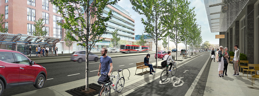
In November 2016, Council approved the final recommendations. 17 Avenue S.E. will ultimately have:
- Two vehicle lanes in each direction
- Median (middle) transitway
- No on-street parking from Stoney Trail to 100 Street and on-street parking from 100 Street to 116 Street.
- Raised cycle track on each side of the road, separated from the sidewalk and road
View the final recommendations for the study area between Stoney Trail and 100 Street S.E. (Parkway)
View the final recommendations for the study area between 100 Street S.E and the east city limit. (Urban Boulevard)
Staging and implementation
The timeline for implementing the final design depends on available funding and the rate of residential and business development in the area.
The staging plan below includes recommendations for short-, medium-, and long-term designs for the study area. The plan accommodates all modes of transportation and helps transition the vehicle-oriented road to an urban street.
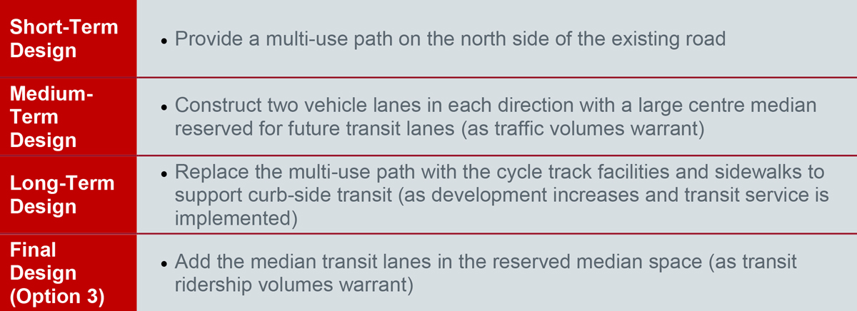
Read the Evaluation and Staging Report to learn more
View the recommended staging plans.
Next Steps:
Residential and business development will be monitored in the study area and as development occurs, the recommendations will be prioritized for funding and a budget will be allocated.
Study overview
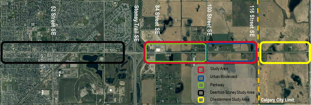
17 Avenue S.E. provides an important regional connection between Calgary and Chestermere. It is also identified in the Calgary Transportation Plan as part of the Primary Transit and Primary Cycling Networks. The study is being completed in two sections. The first section, from Deerfoot Trail to Stoney Trail, was completed in 2011. Today we are conducting the study between Stoney Trail and the east city limit (116 Street S.E.).
Study goals and outcomes
The study area is currently undeveloped. The study will result in a staged concept plan (short-, medium- and long-term) for all transportation modes (walking, cycling, taking transit, and driving).
The concept plan will identify:
- Required land (right-of-way)
- Traffic lanes
- Transit, bus rapid transit (BRT) and light rail transit (LRT) accommodation
- Connectivity for all road users
- Goods movement (truck traffic)
- Access to and from the corridor
Transportation and land use context
17 Avenue S.E. is classified as a Parkway from Stoney Trail to 100 Street S.E., and as an Urban Boulevard from 100 Street S.E. to the east City Limit. Parkway and Urban Boulevard both belong to the Livable family of streets in the Complete Streets Guide. These types of streets are intended to function as destinations as well as travel corridors that enable social interaction (e.g., walking, cycling, transit).
The Belvedere Area Structure Plan (ASP) was approved in 2013, recommending future development of approximately 61,000 people and 14,000 jobs in the area. The ASP outlines an Urban Corridor and Community Activity Centre east of 100 Street S.E. The Urban Corridor will have higher density residential and employment areas, and the Community Activity Centre will connect a broad mix of land uses (residential, employment, retail, institutional) with transit.
Currently, the study area lacks emergency services and infrastructure like water and transportation. Future development is restricted until funding for the necessary infrastructure is in place. This study will not affect the development restriction.
Vision and context workshop
In June 2015, we hosted a vision and context workshop for adjacent landowners and other interested parties. View the presentation, summary of the workshop discussion, and the engagement summary. The input during this phase helped us prioritize and define important factors and guiding principles for the study.
From this workshop, we identified the area constraints and determined that the corridor will have two vehicle lanes and a median (middle) transitway.
Options development workshop
On October 07, 2015, we hosted a workshop for interested parties. 14 people attended and discussed considerations for developing options. View the workshop presentation. We also offered an opportunity to provide input online.
We gathered input on the type and location of:
- Bike facilities
- Parking
- Sidewalk/public realm & green space
Read the engagement summary to learn more.
The input and ideas from the workshop and online feedback was merged with technical analysis to narrow down the preliminary options.
Open house
On January 28, 2016 at the East Hills Walmart, we hosted a drop-in public open house and an online survey from January 29 - February 12 to collect feedback on the preliminary options. View the open house boards, view the preliminary options and engagement summary.
During the engagement opportunities, the majority of participants indicated a raised cycle track is preferred in the study area.
We evaluated all three options using the evaluation framework as well as the public and community member input. Through the evaluation, we determined that the raised cycle track is the best option to include in the recommendations to Council.
Over the next few months, we worked with interested parties to make refinements and finalize the recommendations. Read the Evaluation and Staging Report.
The final recommendations were shared with the public in June 2016 and then presented to Council in November 2016.
Timeline
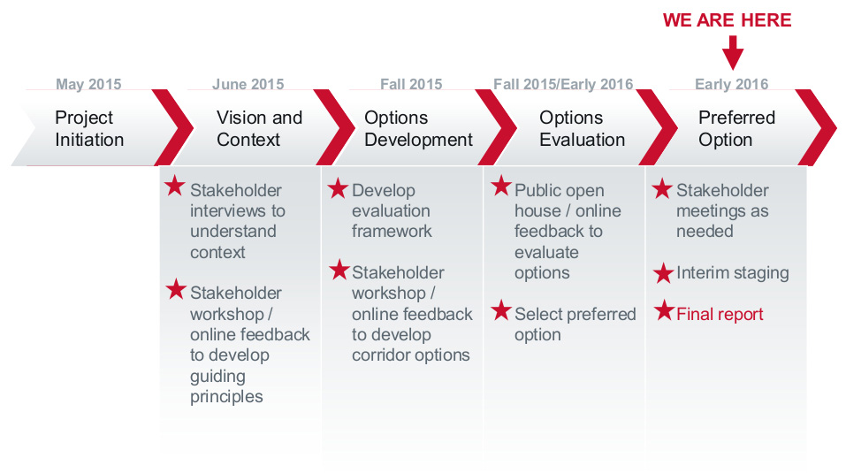
(Click for larger image)
Public engagement
View the 17 Ave Study public engagement summary
The engagement program focuses on consulting a broad range of interested parties including:
- landowners in the study area
- nearby community associations
- government representatives
- others representing various modes of transportation
Alignment with other studies
The recommendations from the 17 Avenue S.E. Corridor Study align with the projects immediately east and west of the study area.
To the east, the approved Chestermere Boulevard Corridor Plan (2014) recommends future BRT/LRT lanes in the middle of the road, two vehicle lanes in each direction, one-way cycle tracks in each direction, and sidewalks on both sides of the road.
To the west, the 17 Avenue S.E. Corridor Study (Deerfoot Trail to Stoney Trail) was approved by City Council in 2010 and then following a public engagement process, finalized in 2011. The final study recommends median transit lanes, two vehicle lanes in each direction, sidewalks, and cycling facilities.