North Central Area Structure Plan
Area Structure Plan North Central
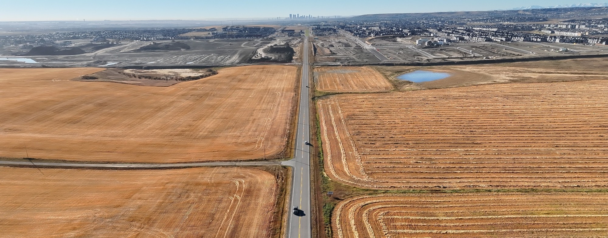
The North Central Area Structure Plan (ASP) will guide future development for about 1,046 hectares (2,585 acres) in north Calgary. The City is leading this work in collaboration with developers, landowners, and other interested parties to create a framework for vibrant, thriving, and complete communities.
Background
The North Central ASP is part of The City’s plan to guide growth in north Calgary. It will follow important city and regional policies like the Municipal Development Plan (MDP), Calgary Transportation Plan (CTP), and the New Community Guidebook (NCGB).
This plan will:
- Set the vision and main goals for future development.
- Show where homes, businesses, roads, and utilities will go.
- Protect important natural areas and plan parks, pathways, and streets.
- Include steps for climate resilience and protecting nature.
Project priorities
The North Central ASP will provide a clear plan for growth, support more housing choices, and coordinate major infrastructure projects like water servicing and the Highway 566 interchange. It will also include strategies to reduce emissions and build inclusive communities.
Our goals are to develop:
Modernized policy framework for complete, connected, accessible and sustainable communities.
Clear, concise and implementable policies.
Site-specific policies supported as required, if and as determined by technical studies.
Engage with internal and external interested parties.
Project delivery aligned with the Developer Funded agreement timeline.
Area map
The North Central ASP area is located north of 160 Avenue and the communities of Livingston and Carrington.
- North: Highway 566 and Rocky View County
- East: Nose Creek ASP Plan Area
- South: 160 Avenue and Livingston
- West: Rocky View County
The area is currently designated as Special Future Urban District (S-FUD) under the Land Use Bylaw and is primarily used for agricultural purposes.
Want to get involved?
Your input is an important part of creating the Area Structure Plan (ASP) for North Central area. Public engagement will happen in three phases:
After these phases of public engagement, the final draft ASP will be posted on our website for review before it goes to City Council for a decision.
-
Want updates on the North Central ASP?
Subscribe to our email list to receive information on important events or project updates.
-
Have your say
To learn how you can participate and share your ideas during public engagement for this project, visit our Engage page.
For questions and additional information on the project, contact NorthCentralASP@calgary.ca.
Frequently asked questions
What is a Developer-Funded Area Structure Plan (ASP), and how does this apply to the North Central ASP?
The City of Calgary uses two models to prepare Area Structure Plans: City-Funded ASPs and Developer-Funded ASPs.
For the North Central ASP, participating developers are funding the City staff resources required to prepare the plan, rather than those costs being paid by taxpayers. The ASP remains a City-led, statutory planning document and must be reviewed and approved by City Council.
Developers submit proposals for new ASP work, which are reviewed by a City selection committee alongside City-funded projects. If selected, developer funding provides additional capacity that can allow planning work to be completed within shorter timelines. All landowners within the North Central ASP area—whether or not they are contributing funding—are treated equally as interest holders throughout the planning and engagement process.
How will environmental features in the North Central ASP area be considered?
For every ASP project, there is a wide range of expert studies to determine things like natural water drainage patterns, wetlands, plant species and wildlife habitats in the project area. These studies will list the requirements for environmental protections on these features, which will then be adopted as policies within the ASP. These studies will also provide recommendations for additional ways to preserve or enhance natural features that can be adopted through the policies and designs included with the ASP.
How does the ASP support affordable housing?
The plan will include policies that allow different types of homes, including affordable options, following Calgary’s Housing Strategy.
How does the ASP plan for climate change?
The ASP plan will include policies to reduce emissions and prepare for climate risks, based on local climate studies.
How will residents benefit from having this plan in place?
An Area Structure Plan (ASP) helps people know what to expect in the future and gives them a chance to help shape the future of their community. It also plans for things like required infrastructure, parks, fire stations, schools, and public transit.
How will transportation and mobility be planned for the North Central ASP and surrounding areas?
Planning how people move in and around the North Central area is a key component of the ASP. Mobility planning considers all modes of travel, including driving, transit, walking, and cycling, as well as connections to surrounding communities and regional corridors.
Planning for roads, pathways, and transit involves many mobility specialists working together. Once a land use concept is prepared, engineers, planners and landowners work together to prepare a Global Traffic Impact Assessment (TIA), which ensures transportation networks are designed to support the community as it grows—while also considering the impacts to and from surrounding communities. The results of the traffic planning and public feedback are reflected in the final draft of the ASP. Once the major street network is identified, intended mobility networks (pathways, transit, cycling) are shown within the ASP document as well.
Who will pay for the cost of preparing this Plan?
Since this Plan is part of a Developer-Funded ASP model, the entire cost of preparing this Plan is covered by developers.
How will The City coordinate infrastructure planning across such large areas?
ASPs provide a coordinated, long-term approach to infrastructure planning. Rather than planning piece by piece, the ASP looks at an entire area together to plan roads, water, wastewater, stormwater, parks, schools, emergency services and more in an integrated way. Based on the findings of expert studies carried out throughout the planning process, development is carefully planned to occur in stages and carried out based on when infrastructure can be delivered. This helps to ensure services are available when needed and future connections are protected. The City also works with neighbouring municipalities and regional partners to align major roads, servicing and mobility networks beyond City boundaries to support efficient, thoughtful growth.
How will the North Central ASP reflect the area’s existing and future character?
In the process of ASP development, the project team works with The City’s archaeologist, park planners, Indigenous Knowledge Keepers, local historians and residents to identify the history and any meaningful details of the area. Together, these inputs give the project team an understanding of the key history and features, and, with this understanding, an idea of the identity of the land. The ASP will include policies to preserve and enhance this identity through place-making, place-keeping, wayfinding, and other community design approaches.