Bowness Flood Barrier FAQ
Project background and process
Can one of the upstream reservoir options the province is exploring completely mitigate the flood risk in Bowness?
No. Based on the three upstream reservoir options being explored by the province on the Bow River, the reservoir will not be large enough to reduce the river flow of a 2013-level flood through Calgary below 800 m3/s to prevent flooding through Bowness. You can read a provincial report for the Bow River Upstream options here:
https://open.alberta.ca/publications/bow-river-reservoir-options-phase-1-conceptual-assessment
What alternatives exist if a flood barrier is never built?
If a flood barrier is never built, we are eliminating one of the fundamental building blocks of the plan that would help deliver a timely, effective solution for Bowness.
Bowness would need to rely more heavily on other longer-term elements of the plan to achieve flood resiliency, such as the upstream reservoir. As well, we would be more reliant on property-level solutions such as property-level floodproofing and changes to permissible development and uses.
Here are some considerations to keep in mind:
- Time: A new upstream reservoir and property-level measures are both long range solutions. An upstream reservoir would take 12+ years for design, consultation, regulatory approvals and construction. Changes to development / redevelopment regulations can take many decades to improve the overall flood resiliency of the whole community, as buildings in Bowness are redeveloped.
- Lower level of flood protection: Without a flood barrier in place, during a large flood, like what we experienced in 2013, a new upstream reservoir on the Bow River may need to release flows that would still cause overland flooding in Bowness. A flood barrier working hand in hand with an upstream reservoir would help reduce the likelihood of this happening.
- Deployment of temporary response measures are not guaranteed: Floods happen quickly and with little warning in Calgary. Constructing kilometres of temporary flood barriers in Bowness may not be achievable if the permanent barrier is not constructed.
Will The City advocate for a larger upstream reservoir before accepting the 1,230 m3/s target?
No. Based on numerous technical studies, we support the Province’s findings that a single reservoir would not be large enough to reduce the river flow of a 2013-level flood to below 800 m3/s to prevent flooding in Bowness because of several factors. This includes the volume of water it would need to accommodate during a 2013-level flood, topography of the area, size of the dam required to accommodate both flood mitigation and water storage, land needed, and the impact to existing infrastructure.
The City will continue working closely with Alberta Environment and Parks to support their studies to find the best possible upstream solution. Having the barrier in place will achieve a higher level of resilience for any upstream reservoirs, including the existing reservoirs and any new reservoir that might be built.
Are other land use changes only going to be considered if there is no barrier?
Property-level protection through updates to building regulations, flood proofing and limiting types of development in flood prone areas have always been a part of the plan that will help make river communities in Calgary more flood resilient.
The difference is that without any community-level structural infrastructure (i.e. flood barrier) in place in Bowness, we would need to rely more heavily on both a future upstream reservoir and property-level measures where flood proofing and changes to permissible development and land use may play a more critical role in achieving greater flood resiliency.
The City is working closely with the Province on the updated hazard maps for Calgary, which are anticipated to be released later in 2021. The maps will reflect not only how a 1:100 flood would affect Calgary, but they will also include new flood zone classifications. As a result, The City will be undertaking a comprehensive review of our existing floodplain policies and regulations and exploring different options for how to regulate these new zones that balance the safety and resilience of the community while ensuring they remain great places to live. City-wide engagement on different policy options, especially with residents and businesses in flood risk communities, will be an important part of the process and will be taking place once the draft flood hazard maps are publicly available.
How much does the TransAlta agreement reduce the flood risk in Bowness?
The TransAlta agreement for modified operations of the Ghost Reservoir remains in effect until 2026 and reduces the flood risk in Bowness to approx. 5% in any given year. In combination with a barrier, this risk of seeing overland flooding could be reduced to around 3%.
Existing reservoirs are able to provide significant mitigation for smaller floods but are not large enough to hold back a large flood, even one smaller than the 2013 flood. However, reservoirs, including the existing Ghost Reservoir, are a useful and flexible form of flood mitigation because they can reduce the peak of even a large flood by some amount, even if they can’t fully hold it back – like they did in 2013.
How were the economic benefits of the flood barrier determined?
A cost/benefit analysis was completed, in addition to considering other criteria as part of economic analysis of the Triple Bottom Line (economic, social and environmental) evaluation. See a full list of the economic criteria.
How was community input used results in evaluating the options?
The survey results from the January 2021 engagement gave us valuable insights into understanding the perspective of Bowness residents. We used the feedback from the community to help rate the importance and weighting for each of the social criteria. We used the verbatim comments that we collected through the online survey to assign a score for each of the seven social criteria:
- Community equity
- Community safety
- Financial impacts to flood affected residents
- Community well-being
- Construction impacts
- Riverfront land aesthetics and enjoyment impacts
- Financial impacts to riverfront landowners
- Read a copy of the What We Heard report (April 2021)
How was the 1,230m3/s flow rate for the flood barrier determined?
The 1,230 m3/s flow rate at Calgary is based on the target flow rate the province is using to explore options for a new upstream reservoir on the Bow River. Previous studies by the province’s consultants found that an 800 m3/s flow rate isn’t achievable with a single reservoir during a 2013-flood scenario.
For details, see the Phase 1 conceptual assessment final report for the Bow River reservoir options.
What other alignments were considered?
We listened to the community and explored the feasibility of an alternative barrier alignment on public property – along Bow Crescent. This option was not pursued further for this feasibility phase as it does not align with The City’s Flood Resilience plan to reduce the flood risk for the entire community. It could also compromise their safety and may impact the emergency response delivered by The City.
What preventative measures may be necessary if the river overtops the barrier?
The flood barrier is designed to protect against river flows of 1,230 m3/s. If an upstream reservoir (current TransAlta or future upstream reservoir) were not able to mitigate a larger flood event down 1230 m3/s or lower resulting in the barrier being overtopped, flood waters would be returned to the river through a combination of improvements to local lot drainage and pumping water trapped in other areas.
How would the barrier be maintained and who is responsible for it?
The property owner would be responsible for regular landscape maintenance. The City would undertake inspections to ensure the flood barrier is in good condition to function during a flood.
Will the flood barrier enable TransAlta to increase the river flow rate through Calgary and thereby increase groundwater flooding in Bowness?
The City will continue to work collaboratively with upstream operators to ensure the reservoirs are operated in a way that limits potential damage from both overland and groundwater flooding, and lowers the peak of the flood to prevent even more widespread damage that would occur without these mitigations in place.
A flood barrier would not increase the likelihood of experiencing higher river flows through Bowness. One of the intentions of the TransAlta reservoir operations during flood season is always to manage the river flows to prevent damage through Calgary as much as possible. Only when an extremely large flood is being forecasted (e.g., around a 2013-level flood), and when the reservoir level and inflows are high enough, would reservoir operators need to increase river flows to make room in the reservoir to help capture the peak of the flood and avoid even more disastrous consequences. Reservoir operations during a flood are based on several factors including public safety and potential damages downstream, the forecast, how quickly flows are rising, and dam safety.
TransAlta’s operation of the reservoirs for flood mitigation results in flows high enough to cause damage coming through Calgary less frequently, not more frequently.
Why has the cost of the flood barrier increased from the initial conceptual design, despite it getting shorter?
This barrier design and alignment is different from the one proposed as part of the city-wide Conceptual study. That concept was an earth barrier, estimated to have a total capital cost of approximately $24.6 million. The estimate did not include costs related to any groundwater mitigation or stormwater drainage under a high river condition.
The updated barrier concept is a combination of earth berms and flood walls designed to minimize impacts to riverfront property and trees as much as possible.
Some properties have multiple barrier options available. How would you achieve continuity between properties?
If the project moves forward at a later date, we would continuing meeting with homeowners and look at meeting with several property owners at a time to consider to everyone’s feedback and work co-operatively to develop a final barrier design that is cohesive between properties and flexible.
What effect would a flood barrier in Bowness have on groundwater during a flood?
- Slightly lower groundwater table. Study results showed that removing overland flow typically resulted in lowering of the groundwater table, on average by 0.4m.
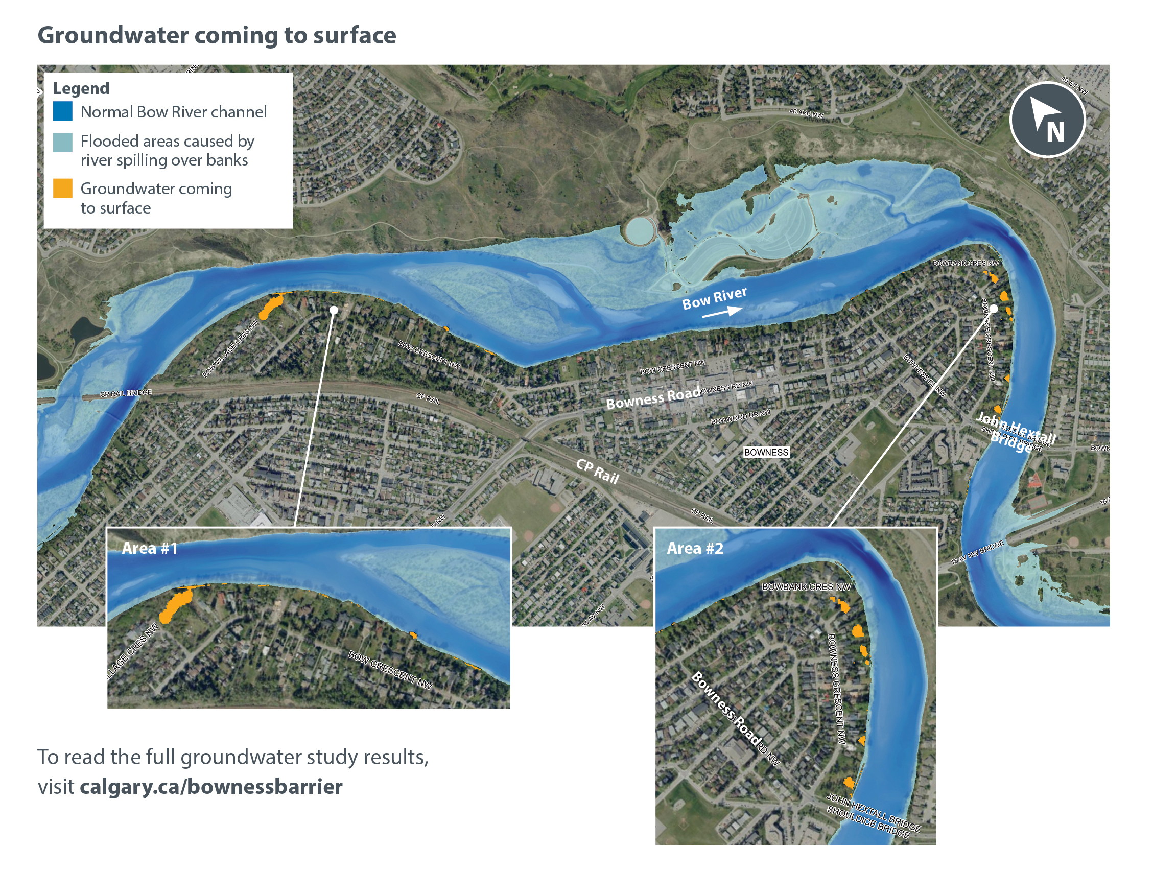
- Localized pockets of groundwater that can be addressed by pumping wells. Our studies showed that when the overland flow is held back by a barrier, during a flood we may still see localized pockets of groundwater coming to the surface in small areas. This is depicted in yellow in the map below.
To mitigate groundwater coming to surface in these areas, localized pumping wells are proposed to lower groundwater levels. The exact location and number of these pumping wells would be determined in consideration with the final barrier placement and would be addressed if the project proceeded to the next phase. Read the full groundwater study results.
How is groundwater considered and addressed in other flood mitigation projects?
We follow a consistent design process for all flood mitigation projects. We conduct studies to understand the existing groundwater conditions and determine how they would change if a flood barrier is constructed.
Typically, where the flood barrier is shown to have remaining and critical impacts on local infrastructure, mitigation is proposed in the impacted area. Where there are no remaining and critical impacts, no specific groundwater mitigation is proposed.
As with all homes in Calgary, we recommend the best way to reduce the risk of basement flooding by taking the appropriate steps at home (see Q&A below for more information).
What is the best way to prevent basement flooding caused by groundwater?
As with all riverside communities in Calgary, managing the risk of basement flooding can be best achieved through a combined approach:
- controlling the river flow through upstream reservoirs to keep groundwater levels low;
- community flood barriers to prevent overland flooding;
- allow property-level measures (such as sump pumps and backflow valves) a chance to do their work; and
- property-level flood protection to limit potential damages.
When river flows cannot be maintained below basement levels, or when the water table rises due to heavy rainfall, an effective way to reduce basement flood risk is taking the appropriate steps at home. This includes:
- Install a sump pump with a back-up power source.
- Install backflow preventer valves on sanitary sewer lines.
- Ensure downspouts drain onto the ground at least two metres away from your home.
- Improve your lot grading so that it slopes away from the house foundation.
- Repair cracks in the basement foundation.
- Finish basements with easily washable materials, such as concrete floors and walls.
- Install water alarms in the basement to alert you if water is backing up.
- Avoid building living spaces below grade.
My property only experienced basement flooding in 2013, how will the flood barrier protect me?
Much of the damage incurred in Bowness during the 2013 flood was in basements. Based on studies and information received from residents we know this damage was a combination of:
- Sanitary sewer back-up resulting from overland flooding on the streets entering the sanitary system
- Overland flooding that entered through windows and doors
- Groundwater seepage through a foundation from an elevated groundwater table
The proposed overland barrier would address the first two types of flooding and help lower the groundwater table to allow property level measures a chance at being effective in keeping groundwater out of a basement.
Can the groundwater model be used to predict how different river flows would affect the groundwater levels on my property?
No, the resolution of the current model does not permit interpretation on an individual property level basis. The main purpose of the model is to provide a better understanding of the groundwater flow system underneath Bowness and to predict how the groundwater table responds during a high water event with and without a surface barrier in place.
Why weren’t some of the groundwater mitigation options from the consultant’s report pursued?
Through the groundwater study, we explored if there were feasible structural options to eliminate the risk of basement flooding caused by a fluctuating groundwater table. As with other riverside communities, we found that any structural mitigation we explored would interrupt the normal flow of groundwater returning to the river and would not be economically feasible.
What is the impact to the natural environment?
During this phase, the purpose of the environmental study was to get a baseline understanding of the area by building an inventory of what exists (e.g. amphibians, reptiles, birds, mammals, vegetation, rare plants and wetlands, soils, fish and fish habitats).
If the project were to proceed to the next phase, a full environmental impact assessment would be completed once an alignment was confirmed. This final assessment would provide information on potential impacts to existing habitat features, fish, wildlife and vegetation and how to mitigate those impacts during construction.
How would trees be impacted with construction of a flood barrier?
Minimizing the impact on trees is an important consideration in design, but the loss of some trees would be unavoidable. The number of trees lost would be determined if the project proceeded to the next phase of design once an alignment was confirmed with the property owner.
At this point, using the feedback we gathered from property owners, we’ve tried to propose alignments that minimize the impact on existing trees as much as possible. The alignments aim to protect trees that have a special significance to property owners and select trees for removal that are at the end of life or otherwise unhealthy.
As part of our restoration of the natural environment we would work with homeowners to plant as many replacement trees as possible on the site.
Is any riverbank reinforcement needed and where?
Most of the riverfront properties in Bowness did not experience significant bank erosion during the 2013 flood. Following the flood, two areas were identified for further study and were conducted privately by Westhoff Engineering.
These areas were explored further during this feasibility phase and one was recommended for erosion protection to ensure the barrier will remain stable. One of the barrier options for this area incorporates natural bank stabilization (vegetation) to provide this protection.
What impact will the loss of old trees (50-75 year) have on riverbank erosion?
As often as possible, the location of the barrier is set back from the edge of the riverbank. This helps to preserve both the mature trees and the natural erosion protection their roots provide.
How would you ensure that a new berm would not introduce weeds into the area?
Any new fill that would introduced into the area to construct a berm is required to be sourced from an accredited supplier that tests the material for the presence of weeds. The fill is also screened prior to delivery.
Will trees and shrubs be preserved between properties?
The number of trees and shrubs that would need to be removed is dependent on the final alignment of the barrier that would be determined in a potential future phase. If the project advanced we would continue to work with property owners to advance the design in a way that minimizes the impact on trees and shrubs as much as possible and explore alternative ways to make up for the loss of trees.
How would construction impact nesting birds?
Nesting birds are federally protected birds and if the project was approved in a later phase to move into construction, through the planning process we would plan construction activities to prevent harming migratory birds, nests and eggs.
Back to top