

Sunnyside Flood Barrier
Sunnyside Flood Barrier
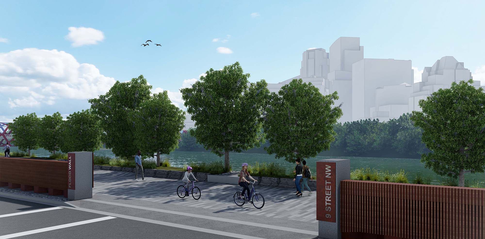
Protecting the communities of Sunnyside and Hillhurst from flooding while improving pathways and public spaces in the area.
Project overview
The 2.4-kilometre Sunnyside Flood Barrier is designed to protect people, homes and businesses in Sunnyside and Hillhurst from a 1-in-100-year flood. This means it can help protect the community from a flood that has a one per cent chance of happening in any given year.
The project also improves pathways, public spaces, and connections along Memorial Drive and the Bow River corridor.
Benefits
-
Safer communities
People, homes and businesses will be projected from a 1-in-100 year flood.
-
Better pathways and connections
Improved pathways and public spaces along the river for people walking, wheeling and cycling.
-
Enhanced public spaces
New landscaping, gathering spaces and river corridor improvements help people enjoy the area year-round.
-
Long-term resilience
The barrier supports Calgary’s flood mitigation strategy and helps prepare communities for future climate impacts.


After reviewing different options and gathering community feedback, Council approved this level of protection because it provides the best balance between flood protection, community impacts and long-term value.
A 1-in-100-year barrier:
- Reduces the risk of flooding, like the 2013 flood.
- Meets the provincial and federal flood protection standards.
- Helps protect people, homes and businesses.
- Fits better with the community’s character than larger barrier options.
- Supports vulnerable populations during flood events.
- Supports Calgary’s long-term flood resiliency strategy.
The barrier will reduce flood risk today, and additional upstream flood mitigation projects will provide even greater protection in the future.
Project location
Ward: 7
Communities: Sunnyside and Hillhurst
The project extends along the Bow River and Memorial Drive corridor between approximately Centre Street N. and 14 Street N.W., including areas around Kensington, Prince's Island access points and adjacent river pathways.
Project phase
Latest updates
The Sunnyside Flood Barrier is operational and protecting Sunnyside and Hillhurst from a 1- in-100 flood.
Restoration work, landscaping, pathway improvements and public space enhancements continue throughout 2026. Temporary lane closures and pathway detours remain in some areas while this work is finished.

Timeline
Final restoration, landscaping and pathway improvements.
The flood barrier became operational in time for the 2026 flood season.
Construction of flood walls, sheet piling, utilities, pathways and river corridor improvements
Construction started on the flood barrier and related pathway, utility and public realm improvements.
The City completed technical studies, evaluated flood mitigation options and worked with the community to develop the preferred design.
Council approved the recommended flood mitigation approach and the 1-in-100-year flood protection level for Sunnyside and Hillhurst.
Construction
Road Closures
Road Closures
| Location | Closure Details | Status and anticipated Schedule | Impact |
|---|---|---|---|
|
Location
:
Eastbound Memorial Dr east of 14 St N.W. towards 10 St N.W. |
Closure Details
:
Single lane closure |
Status and anticipated Schedule : April 13 – end of September | Impact : One right lane closed 24/7 for pathway and landscaping work |
| Location : Eastbound Memorial Dr between 10 St N.W. to 5A St N.W. | Closure Details : Single lane closure | Status and anticipated Schedule : April 20 – end of October | Impact : One right lane closed 24/7 for curb and roadway restoration and pathway upgrades. |
Pathway Closures
Pathway Closures
| Location | Closure Details | Status and anticipated Schedule | Impact |
|---|---|---|---|
| Location : 14 St N.W. to 10 St N.W. | Closure Details : Full closure of the wheeling pathway | Status and anticipated Schedule : Ongoing - mid-September | Impact : Wheeling traffic will be detoured to the south (downtown) Bow River Pathway. Pedestrian pathway will remain open. |
| Location : 9A St N.W Pedestrian Overpass | Closure Details : Full closure of the overpass | Status and anticipated Schedule : Ongoing - mid-September | Impact : The 9A St N.W. pedestrian overpass over Memorial Dr is fully closed. Pedestrians can cross at 10 St N.W. and wheeling traffic can use the 1 Ave N.W. roadway detour. |
| Location : 9A St N.W. LRT Bridge closure | Closure Details : Full closure of the LRT Bridge | Status and anticipated Schedule : Ongoing - mid-September | Impact : Pedestrian detours include 10 St N.W. Bridge or Peace Bridge to access downtown or Sunnyside/Kensington. Wheeling detours include 14 St Bridge or the Peace Bridge to 1 Ave N.W. roadway detour. |
| Location : East of LRT Bridge to Peace Bridge | Closure Details : Full closure of the Bow River Pathway | Status and anticipated Schedule : Ongoing – mid-October | Impact : Pedestrians detour to the north side Memorial Dr N.W. sidewalk. Wheeling detours include the south (downtown) Bow River Pathway or the 1 Ave N.W. roadway detour. |
| Location : Memorial Dr. crossing at 7 St N.W | Closure Details : Full closure of the crosswalk | Status and anticipated Schedule : One day in mid-September | Impact : Pedestrian and wheeling traffic will be detoured to the 9A St. N.W. pedestrian overpass. |
| Location : 14 St N.W. to 10 St N.W. | Closure Details : Full closure of the pedestrian pathway | Status and anticipated Schedule : Mid-September - October | Impact : Pedestrians will detour onto the new multi-use pathway closer to Memorial Dr. N.W. |
Mitigating construction impacts
We know construction can be disruptive, and we are working to reduce impacts while delivering the infrastructure Calgary needs.
-
Coordinating with nearby projects
Reduce impacts you experience in the area.
-
Clear detour signs
Guiding you around construction with clear, visible routes, helping you travel easier and safer through the area.
-
Monitoring vibrations
Protecting nearby buildings, bridges and underground infrastructure to keep you safe.
-
Maintaining access
Keeping access open to homes, businesses, parks and community spaces throughout construction


Image gallery
Take a virtual tour of the flood barrier
Project documents
Budget and funding
$73 million
Frequently asked questions
Flood protection
How much flood protection will the barrier provide?
The barrier is designed to protect Sunnyside and Hillhurst from a 1-in-100-year flood event. This means it can protect the community from a flood that has a one per cent chance of happening in any given year.
This level of protection:
- Reduces flood risk to homes, businesses and infrastructure.
- Meets provincial and federal flood protection standards.
- Supports Calgary's long-term climate resilience efforts.
What’s the risk of flooding in Sunnyside?
Homes, buildings and other infrastructure in Sunnyside are impacted when river flows reach levels of 927 m3/s (1:10). There is a 10 per cent chance of this occurring every year. Find out if your property is at risk of flooding.
What measures will protect Sunnyside from future flooding?
To protect Sunnyside from future flooding, the Flood Mitigation Measures Assessment (FMMA) report, approved by Council in spring of 2017, recommended that a combination of mitigation solutions that work together to create a flexible and adaptable flood risk management program. Each piece of the strategy provides great benefits independently, but together, they ensure the most effective flood protection strategy.
Below is a summary of this multi-measure approach to building flood resiliency that includes the construction of a new upstream reservoir, as well as changes to the TransAlta’s Ghost Reservoir and the construction of community-level flood barriers.
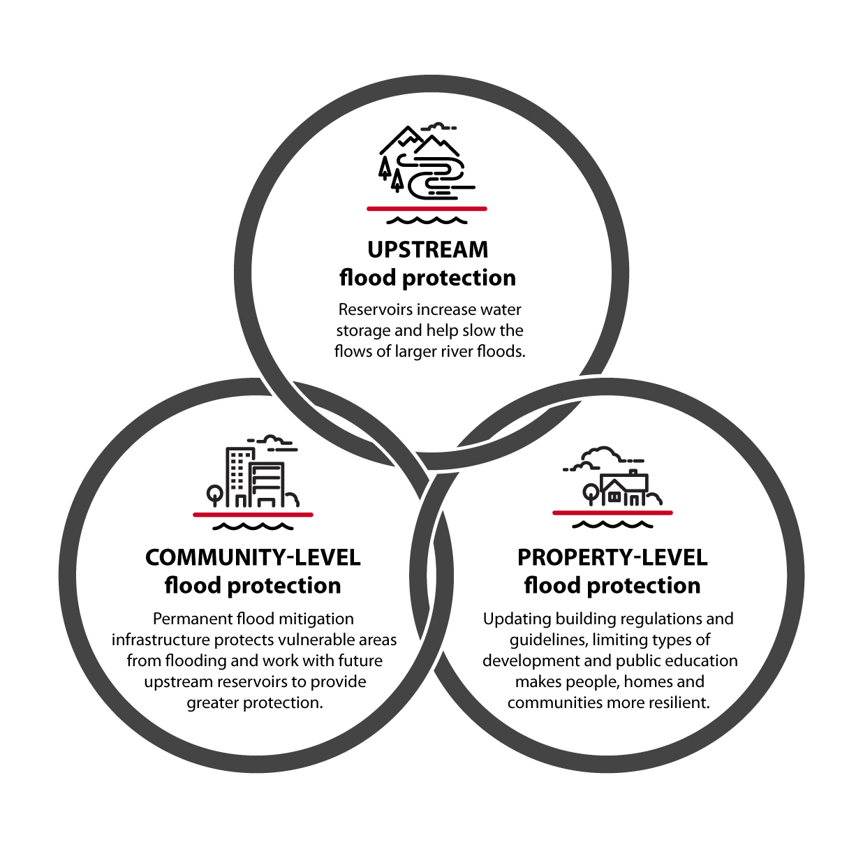
Learn more about Calgary's Flood Mitigation and Resiliency Plan.
How does this project fit into Calgary's flood mitigation strategy?
The flood barrier is one part of Calgary's broader flood mitigation strategy. Other measures include upstream flood storage projects, reservoir operations and community-level flood protection projects.
Together, these measures help reduce flood risk across Calgary.
Learn more about The City’s Flood Mitigation Strategy:
How is The City addressing other sources of flooding in Sunnyside?
Due in part to the geography as well as an outdated drainage system, Sunnyside is more prone to flooding and this is something that The City is working to fix. In addition to the flood barrier, several projects have been completed or are currently underway to reduce flooding that happens in the community.
Visit Calgary.ca/sunnysidecdi for a list of projects and up to date information.
Flood barrier design
How tall is the flood barrier?
The section of barrier between Centre St and 10 St N.W. is an average height of 1.5m. The maximum height of the barrier will be 3.4m in certain sections depending on existing elevation.
What is the flood barrier made of?
The barrier uses three types of flood protection systems based on site conditions.
- Sheet pile flood wall (about half the barrier is sheet pile)
A permanent steel wall installed deep below ground to help hold back flood water.- Works well in areas with limited space
- Minimizes construction impacts
- Reduces the need for tree removal
- Is only used where it will not affect groundwater flow
- Concrete flood wall
A permanent concrete wall designed to hold back flood water.- Designed to hold back flood water
- Requires more space and construction activity
- Used in areas where groundwater must move freely beneath the wall
- Demountable flood wall
A temporary wall installed only during flood events.- Set-up during emergency conditions
- Removed when not needed
Trees and landscaping
Why were trees removed?
Removing a tree is always a last resort. Some tree removal was necessary to build the flood barrier and improve public spaces in the area. Approximately 200-250 tree removals are required as part of the project.
The project team adjusted the design where possible to reduce tree loss.
Before construction began, every tree in the project area was inventoried and assessed.
For more information on Memorial Drive Trees, please visit Memorial Drive trees.
How many trees will be replanted?
The project includes planting approximately 250 new trees, along with new shrubs and flowers throughout the corridor.
These plantings will help restore the area and support a healthy urban forest.
For more information on Memorial Drive Trees, please visit Memorial Drive trees.
What happens to the trees that were removed?
Whenever possible, removed trees are reused to support environmental and community projects, including:
- Fish habitat improvement projects.
- Wildlife habitat restoration.
- Planting beds and seating areas in Sunnyside and around Prince's Island.
For more information on Memorial Drive Trees, please visit Memorial Drive trees.
Construction
Is vibration monitoring used during construction?
Yes. Vibration monitoring is used during sheet pile installation to help protect nearby utilities, bridges, buildings and homes.
Will bridges and pathways remain open?
The Peace Bridge and the Prince's Island Park Pedestrian Bridge remain open during construction. Temporary pathway detours may be required in some areas while work is underway.
Will The City install a pedestrian crossing at 8 Street N.W. to mitigate illegal pedestrian crossings?
During project planning, community members were asked about pedestrian crossings along Memorial Drive. Based on feedback, the project retained the existing crossings at 7 Street N.W. and 9 Street N.W. instead of adding a new crossing at 8 Street N.W.
The barrier design includes features (like a concrete wall with a railing and boulders) that discourage unsafe crossings along Memorial Drive.
Contact
Email: rileyareaprojects@calgary.ca
Contact: 311
Nearby projects
-
Calgary River Valleys Project
Planning the future of Calgary’s river valley areas to support resilient river communities
-
Memorial Parkway Program
Discover projects along the Memorial Park Corridor
-
Riley Area construction projects
Coordinating construction and project information in the area.
-
Downtown Flood Barrier & Eau Claire Promenade
Protecting Calgarians from flooding while enhancing Eau Claire.
-
Riley Area improvements
Improving safety, accessibility and public spaces in the Riley Area.